Good evening from Southern Connecticut Weather.
Exceptional. Historic. Dangerous. All of these words could be used to describe Hurricane Irma, one of the strongest hurricanes the tropical Atlantic has ever seen.
As of 8pm, Irma is a category five hurricane in the Atlantic. It is 85 miles east of Antigua and moving just a touch north of due west at a good clip. Irma has sustained winds of 185mph. The record in the Atlantic is 190 mph.
A number of hurricane hunter planes are out in the storm currently, and it is quite possible that Irma is still strengthening. If you look at the infrared satellite, you can see why.
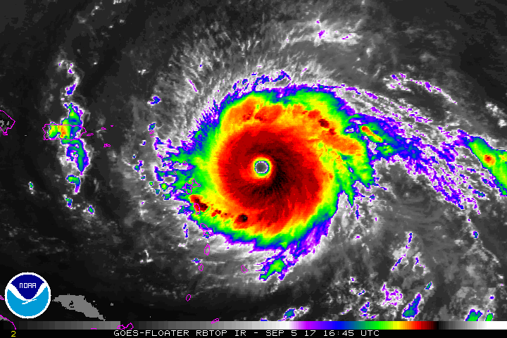
Irma is a symmetrical storm in an environment of low shear, high and deep sea surface temperatures, and atmospheric moisture. There are few things holding it back. One, is land interaction. If Irma hits Cuba or Hispaniola it would seriously disrupt the core. The other, and more likely, are eyewall replacement cycles. These reorganizations of the hurricane’s center happen frequently in strong hurricanes, and often plateau or weaken storms. However, ERCs also expand the wind field of the system, and that has been the case with Irma.
The Forecast
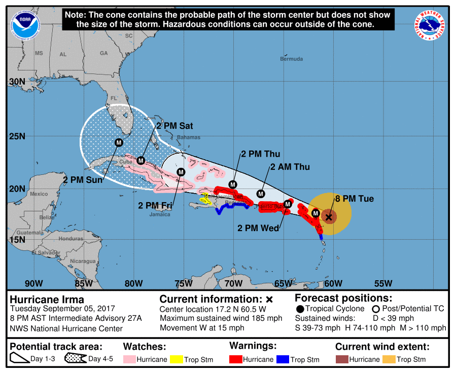
There isn’t much to say about the track. It remains likely that Irma will pass near or just north of Puerto Rico and Hispaniola and into the Bahamas by the end of the week. By then, the forecast becomes much more uncertain. The guidance remains split on whether Irma continues into Cuba, but there is large consensus that there is a turn to the north that happens as the steering flow develops a weakness allowing for a turn.
If you are watching the models, remember that we are looking at a highly convoluted and complex upper level pattern. Do not become attached to one model run or series of runs. Track and intensity is highly sensitive to atmospheric changes, and we will not have consensus on long term evolution for a while. However, the odds continue to increase that some or much of Florida will see significant impacts.
There is currently no imminent threat to Connecticut.
As I said over the weekend, the pattern as currently modeled does not look similar to patterns in the past that have brought landfalling tropical systems. However, this far out, the errors among even the best models and forecasters is at least 100 miles. Few things seem to be off the table at this time. This is about as serious a storm as the east coast can see, and we will continue to watch it. What I said Sunday continues to ring true.
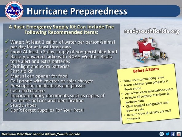
As we are entering the peak of hurricane season, you should be prepared for a storm irrespective of whether there is a threat or not. If you have family and friends in Florida, the southeast, or islands, make sure they are prepared for what could be a very strong storm.
If you are watching the models, remember that we are looking at a highly convoluted and complex upper level pattern. Do not become attached to one model run or series of runs. Track and intensity is highly sensitive to atmospheric changes, and we will not have consensus on long term evolution for a while. However, the odds continue to increase that some or much of Florida will see significant impacts.
There is currently no imminent threat to Connecticut.
As I said over the weekend, the pattern as currently modeled does not look similar to patterns in the past that have brought landfalling tropical systems. However, this far out, the errors among even the best models and forecasters is at least 100 miles. Few things seem to be off the table at this time. This is about as serious a storm as the east coast can see, and we will continue to watch it. What I said Sunday continues to ring true.
- There remain fundamental questions about the future track of Irma. All options remain on the table, though if I were placing odds right now, I would lean strongly against any direct New England hit. The currently modeled pattern does not look like a classic hurricane pattern for the region, but I think there is a heightened risk of a US impact somewhere.
- It will be another few days at least before we have a better sense of what the track will be. Don’t get caught up with whatever others are saying on social media. At this range model solutions are not reliable.
- Although it is too early to determine what direct impacts Irma might have on the continental United States, I urge everyone in hurricane-prone areas to ensure that they have their hurricane plan in place, as we are now near the peak of the season.
As we are entering the peak of hurricane season, you should be prepared for a storm irrespective of whether there is a threat or not. If you have family and friends in Florida, the southeast, or islands, make sure they are prepared for what could be a very strong storm.
Rest assured, the SCW team will continue to closely monitor Irma. We will be back with updates as necessary. As always, please like, share, and interact with us on our social media--on Facebook to share our discussions, and follow us on Twitter @southernctwx to retweet our posts! Hit the buttons below to join!
-DB
-DB
