Good morning from Southern Connecticut Weather!
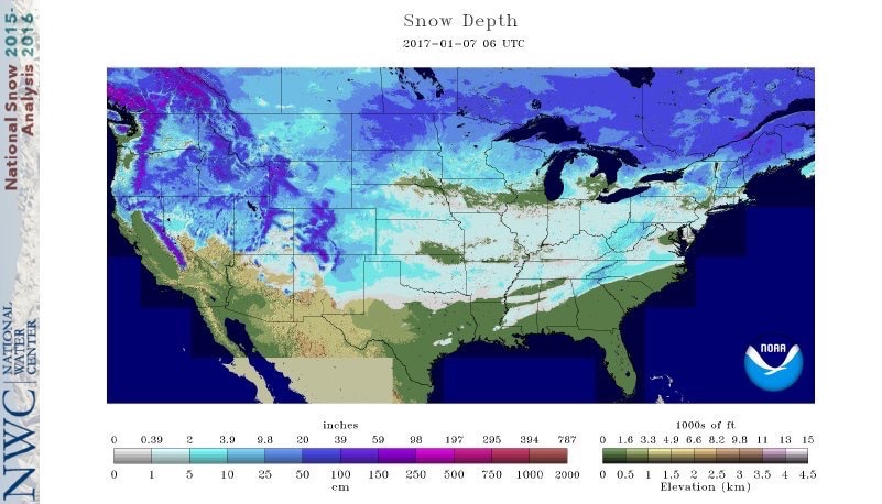
Today, in every state in the nation except Florida, some portion of its citizens are waking up to snow cover. The two systems of the past weekend have left conditions resembling deep winter across much of the nation, and Connecticut is no exception. We’ll have a wrap up of the storm at some point, but there’s no rest for the weary as we have to chart out what weather to expect for the week ahead!
Today, in every state in the nation except Florida, some portion of its citizens are waking up to snow cover. The two systems of the past weekend have left conditions resembling deep winter across much of the nation, and Connecticut is no exception. We’ll have a wrap up of the storm at some point, but there’s no rest for the weary as we have to chart out what weather to expect for the week ahead!

Today
This Sunday is one to stay inside and enjoy playoff football. Today we woke up with a mix of clouds and sun, but I expect cold conditions today, with temperatures well below normal and wind chills in the teens and single digits. I’m closely watching the progress of an arctic front, which will be pushing through the region today. The front will be accompanying a strong shortwave, and that’ll assist in creating an environment conducive for snow showers and squalls. Not everyone will see snow today, but I am a bit concerned about the potential for a squall to produce brief whiteout conditions and put down heavy snow for a period that would accumulate on roads given these temperatures.
In terms of timing, I expect the potential for squalls to be greatest between 2-9pm. Northern and western parts of Connecticut are most likely to see snow flying, but the entire state should be watching for the potential.
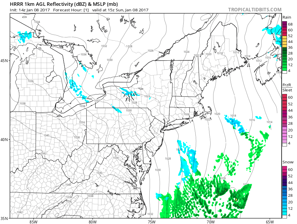
Short resolution guidance showing the potential progression of snow showers and squalls.
Monday
With the passage of the arctic front, things clear out again and Monday is another very cold day. With fresh snow cover, high pressure building into the area, and calm conditions, Monday morning looks to be very cold across the state. Be sure to bundle the kiddos up well! Aside from the cold, Monday should be a quiet day.
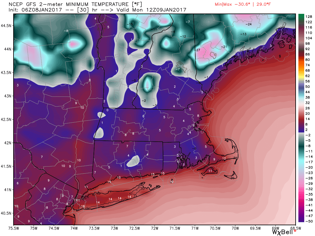
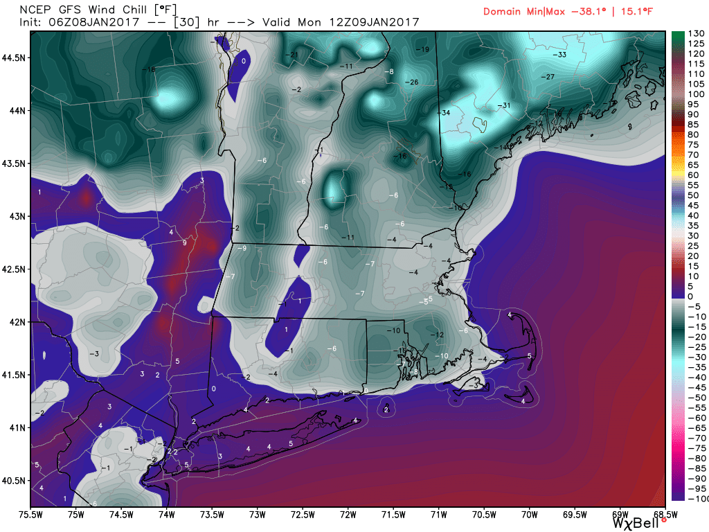
GFS windchill (bottom) and low temperature (top) projections for tomorrow morning around 7am. Cold start! The euro, which we cannot post, is even colder! Images courtesy of Weatherbell Analytics.
This march into deep winter will not last forever, however. By Monday night, high pressure will shift off the coast, bringing a more southerly flow that will allow temperatures to rise. We’re still going to be seasonably cold, but this will begin to set the stage for the rest of the week.
Tuesday/Wednesday
Tuesday is expected to be warmer, but seasonable. A low will approach from the west, meaning that rain is coming. The first precipitation is currently expected to break out Tuesday afternoon and evening. With cold in place, I am thinking that we start off with snow in many northern locations and maybe a mix toward the shore. That will quickly change to rain however, as we transition into Wednesday. Wednesday looks wet, through at least early afternoon, and in the warm sector of this storm, I expect temperatures to rise well above normal, with temperatures approaching 50! I’ll be watching to see if cold air is able to hang on longer than anticipated. Sometimes the cold air is underestimated in these setups. Currently, I expect little to no accumulation of the wintry type on Tuesday outside of the northwest hills.
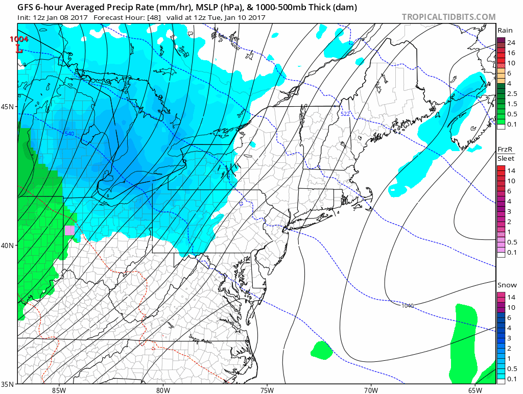
GFS progression of the Tuesday/Wednesday system. We start off with a snow/mix but quickly go over to plain rain.
Thursday/Friday
Things mostly clear out after the storm passes Wednesday, but winter does not make an immediate return. High pressure is expected to build off the southeast coast by this time, and for anyone that follows the weather closely, the associated ridging that comes from a southeast high typically means warmer than normal temperatures. With a low to the north traversing the region, Thursday and Friday look cloudy and warm, with temperatures approaching 50 each day. Friday in particular could be a day where we top 5-0!
Saturday
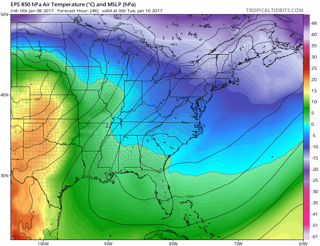
The above image, the Euro ensembles show very clearly why we’re going to torch the second half of the week, why my temperature call for week two in my two-week outlook is going to bust and why next weekend starts to get tricky.
Ridging dominates the east coast next week, bringing warmer air at the surface and aloft into the state. Do you notice that warm nose of 850mb temperatures heading into the state at the end of the week?
You also see Saturday, when the 850mb temps begin to crash again. Right now, next Saturday looks fine. However, we are seeing a signal for more wintry weather potential next weekend. It’s not worth going into detail about since the overall evolution looks even more convoluted than this past weekend, but with a boundary pressing from the north and moisture potentially coming from the south or west, it is something to keep a casual eye on…
The dailies
Sunday: Mix of sun and clouds early giving way to cloudy conditions. Breezy and cold with a chance of snow showers and squalls. Highs in the upper teens to low 20s. Chance of snow 50%.
Monday: Partly cloudy and cold. Highs in the low to mid 20s.
Tuesday: Increasing clouds. Snow/mix in the early afternoon changing to rain. Highs in the mid to upper 30s. Chance of precipitation 70%
Wednesday: Rainy and seasonably warm with clearing beginning by mid-afternoon. Highs in the upper 40s to low 50s. Chance of rain early 90%.
Thursday: Mostly cloudy and seasonably warm. Slight chance of a shower. Highs in the upper 40s to low 50s. Chance of showers 20%.
Friday: Mostly cloudy and seasonably warm. Highs in the upper 40s to low 50s.
Saturday: Potential period of interest. Mostly cloudy and colder. Highs in the low to mid 30s. Chance of precipitation 20%.
Thanks for reading!
-DB
