The warm air that is causing overrunning to occur comes from a low that tracks north to our west. Usually, these events cut west of us and flood our area with warmth and result in rain, but because of the strength of the high and the antecedent airmass, it acts as a barrier for the low, forcing it to head east and redevelop off the coastline. This coastal will form the second portion of the event, as it will bring a round of precipitation to most of the state as it passes south of us and out to sea.
Surprisingly, especially considering the winter we’ve had with regards to the models, we’ve got pretty good consensus with this one on the models, with all in relatively good agreement that the initial overrunning will feature the heaviest snows to the north of the state, with the northern portion of Connecticut being able to sneak into the steady snow while further south will see snow showers and flurries on Saturday. Another round of overrunning arrives on Sunday, and models are more intense with this but also are in good agreement with keeping the heaviest north of the region, although the consensus still brings accumulating snow down to the coastline. In general though, not really expecting any heavy snow from this portion of the event, as modeled QPF is light and there are no real suggestions on the models that it could be underdone.
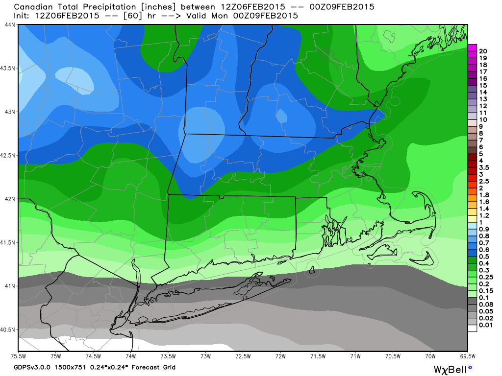
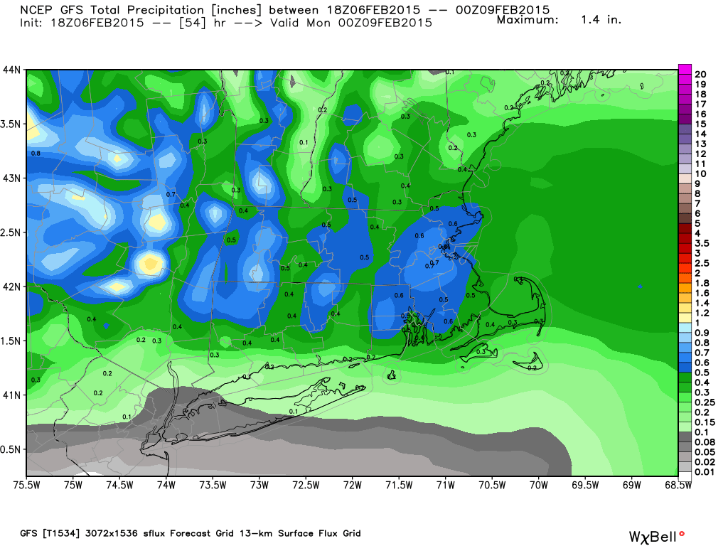
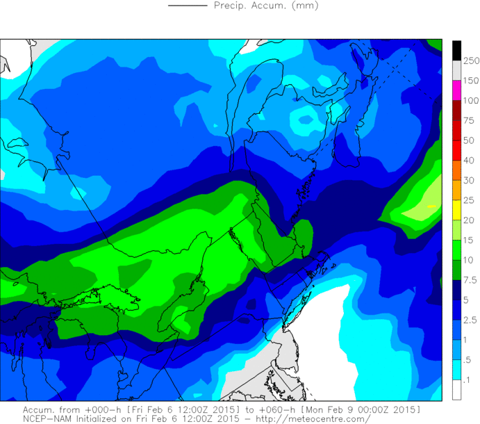
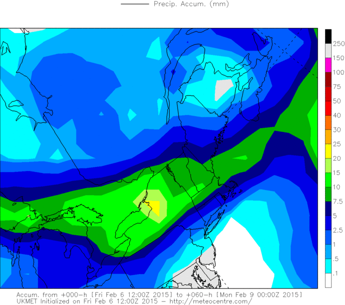
Here’s images of total QPF through 7 PM Sunday night from some of the various computer models. For the models that are in millimeters(UKMET, NAM and RGEM(which is only through 1 PM as it only runs to 48 hours), 1mm = 0.04”). We’re looking at snow ratios between 10-15:1 for this portion of the event, so figure .1” of QPF is between 1” and 1.5” of snow. In general, this suggests several inches of snow in northern areas are likely by the end of the day Sunday, with lesser amounts further south. The NAM model is a far northern outlier and suggests little to no snow for the region, but considering it’s reputation for doing that and the fact that it makes no meteorological sense, I am tossing it for the purposes of this forecast.
Surprisingly, especially considering the winter we’ve had with regards to the models, we’ve got pretty good consensus with this one on the models, with all in relatively good agreement that the initial overrunning will feature the heaviest snows to the north of the state, with the northern portion of Connecticut being able to sneak into the steady snow while further south will see snow showers and flurries on Saturday. Another round of overrunning arrives on Sunday, and models are more intense with this but also are in good agreement with keeping the heaviest north of the region, although the consensus still brings accumulating snow down to the coastline. In general though, not really expecting any heavy snow from this portion of the event, as modeled QPF is light and there are no real suggestions on the models that it could be underdone.
Here’s images of total QPF through 7 PM Sunday night from some of the various computer models. For the models that are in millimeters(UKMET, NAM and RGEM(which is only through 1 PM as it only runs to 48 hours), 1mm = 0.04”). We’re looking at snow ratios between 10-15:1 for this portion of the event, so figure .1” of QPF is between 1” and 1.5” of snow. In general, this suggests several inches of snow in northern areas are likely by the end of the day Sunday, with lesser amounts further south. The NAM model is a far northern outlier and suggests little to no snow for the region, but considering it’s reputation for doing that and the fact that it makes no meteorological sense, I am tossing it for the purposes of this forecast.
Good evening to you from Southern Connecticut Weather!
Well, no rest for the weary here, as we’ve got another snow event bearing down us, and this one looks like it wants to stick around for a while, starting tomorrow afternoon in northern parts of the state and lasting until the wee hours of Tuesday morning. Thankfully, we won’t be seeing the sort of snow rates we did with the last event because otherwise we’d be measuring snow in the triple digits, but a long duration light to moderate snow event is possible, resulting in some significant accumulations when all is said and done for the region. In this discussion, we’ll take a look at the setup as well as the models and the trends, issue a first call map, and discuss possible impacts. A final call map will be issued tomorrow afternoon-evening.
Setup/Models/Trends
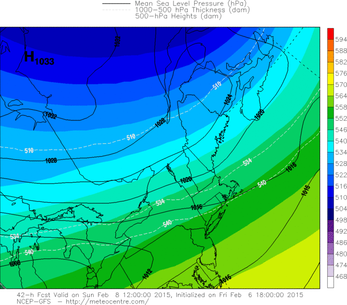
This event will be split into several distinct parts, but for the purposes of this explanation, we can classify the precipitation as coming from either overrunning precipitation or a coastal low. Initially, precipitation from tomorrow into Sunday will be from overrunning along a thermal boundary, that is, warmer air aloft moving on top of very cold air at lower levels and the resulting instability producing periods of precipitation. The reason that we don’t warm up in the low levels as a result of the midlevels warming is that there is a strong high pressure to our north, which is allowing the antecedent air mass to remain dammed into the lower levels and is also providing a source for fresh cold air to stream southward into the region. Here’s a map of the high from the GFS model.
Well, no rest for the weary here, as we’ve got another snow event bearing down us, and this one looks like it wants to stick around for a while, starting tomorrow afternoon in northern parts of the state and lasting until the wee hours of Tuesday morning. Thankfully, we won’t be seeing the sort of snow rates we did with the last event because otherwise we’d be measuring snow in the triple digits, but a long duration light to moderate snow event is possible, resulting in some significant accumulations when all is said and done for the region. In this discussion, we’ll take a look at the setup as well as the models and the trends, issue a first call map, and discuss possible impacts. A final call map will be issued tomorrow afternoon-evening.
Setup/Models/Trends
This event will be split into several distinct parts, but for the purposes of this explanation, we can classify the precipitation as coming from either overrunning precipitation or a coastal low. Initially, precipitation from tomorrow into Sunday will be from overrunning along a thermal boundary, that is, warmer air aloft moving on top of very cold air at lower levels and the resulting instability producing periods of precipitation. The reason that we don’t warm up in the low levels as a result of the midlevels warming is that there is a strong high pressure to our north, which is allowing the antecedent air mass to remain dammed into the lower levels and is also providing a source for fresh cold air to stream southward into the region. Here’s a map of the high from the GFS model.

There remains a bit more uncertainty in the placement and intensity of the coastal low. The GFS model is the most aggressive with it, bringing warning level snows to the northern portions of the state and significant icing to southern areas after some additional snow due to the warming midlevels, while the GGEM says what coastal and slides it well out to sea, only bringing some light accumulations. The UKMET and EURO are the middle ground solutions right now, and as a result will favor those two for the purposes of the forecast. That results in a few to several additional inches of snow, but introduces a possibility of icing along the south coast due to the warming midlevels that we mentioned earlier. I do not expect any plain rain with this event considering the strength of the cold airmass and the positioning of the high to our north.
In general, since this is a first call, went slightly towards the conservative side re. snow amounts considering that either a shift north or a slight tick warmer in the midlevel’s will result in snow accumulations being towards the lower end or even below the low end of this range. If models remain as they are now, will likely up amounts a bit for northern areas tomorrow, but started a bit low as to allow a little wiggle room with the models. Will reassess tomorrow…
Forecast/Timing
Here’s our first call snowmap for this event.
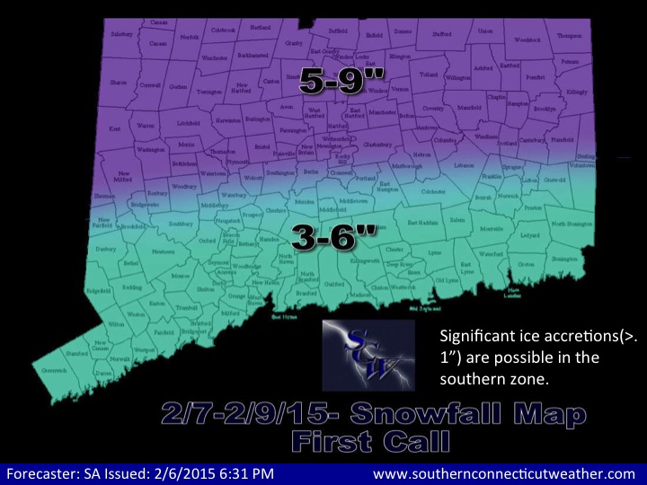
We’re expecting scattered to numerous snow showers to overspread the state tomorrow, however, accumulations and intensities will remain light, generally under an inch for most although some localized areas, especially in the northern section of the state, could come close to 2” if they get under a heavier band for a time. Steadier snow moves in Saturday night into Sunday morning and persists for most of the day Sunday, with the heaviest intensities and accumulations in northern areas and much lighter to the south along the coast. By 7 PM Sunday, expecting accumulations to be in the 3-5” range in the northern zone of the map and in the 1-3” range in the southern zone of the map. Throughout the day on Sunday, intensities should remain relatively light, and as a result while roads may become slippery and snow covered, travel should be OK as long as you keep it slow.
Sunday night into Monday, as the coastal moves in, things get a little more dicey. Precipitation rates should increase across the state, and snow will become heavier in the areas that do remain all snow, with rates of around 1” per hour possible in the heaviest bands. Further south, the midlevels likely warm above freezing along the coast and just inland as a result of the coastal low pushing to the north, allowing icing to become a concern in those areas after a period of snow, and significant ice accretions(over a tenth of an inch) are possible as a result. There is a slim chance that accretions break the half inch barrier that usually signifies the start of more widespread issues related to power lines and branches, but as of now we are thinking amounts remain below that threshold. Further north, snow continues throughout the day Monday. All areas should flip back to snow Monday afternoon and evening as the low pulls away, and by daybreak Tuesday this marathon event has crossed the finish line and we will be dry once again.
In general, thinking accumulations for the coastal are in the 2-4/3-6” range statewide, with icing in southern areas offsetting the higher QPF that will be found there. This is a much lower confidence forecast than the overrunning portion of the event, however, as a small shift in the track of the low in either direction would make major changes in the snowfall amounts result. When we combine this with the accumulations from the overrunning, we get a storm total of 3-6” in southern areas and 5-9” in northern areas. As we mentioned earlier, we are staying more towards the conservative side right now as far as snow amounts go, and will likely adjust upwards tomorrow by a bit if modeling holds or trends south, but we thought this was a good place to start.
Impacts
· Long duration light to moderate snowfall leads to a plowable snow for the state
· Icing possible along the coast and just inland with significant accretions possible.
· Tricky travel from Sunday into Monday, both commutes on Monday impacted.
· Isolated to scattered power outages along the south coast from icing.
· Roof collapses are possible due to the weight of this snow plus the snow from the Blizzard and last weekend’s event. Consider raking your roof or having it done for you if there is a significant amount of snow on it.
· A major hassle for municipalities and individuals that are trying to figure out where to keep all of this snow we’ve been getting!
We’ll be back tomorrow with a final call map and discussion, but until then, enjoy the snow, ask us questions if you’ve got them either here or on Facebook(likely a faster response from the latter), and thank you for reading SCW!
-Spencer
