Forecasters Discussion for 4/28/18
Good evening from Southern Connecticut Weather! Some wet weather today and this weekend looks to lead us weather-wise into a beautiful week next week. After what has been a cold, and abnormal April, we finally have some spring weather to look forward to in the forecast ahead.
Currently
Widespread scattered showers are leaving the state, with temperatures keeping fairly warm in the mid to upper 50s statewide.
Tonight/Thursday
Showers will taper off in the late hours of Wednesday night for the majority of the state. Cooling temperatures coupled with high dew points associated with the moist air will bring a chance for fog to develop overnight. Thursday looks nice as weak high pressure builds in behind the system, and a cold front crosses through the region bringing drier air.
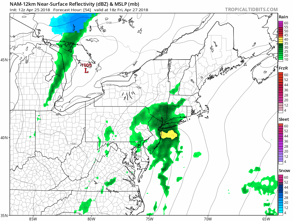
Friday
Clouds will build in early in the day and thicken ahead of our system for Friday afternoon. Models agree that the storm should begin to affect the CT area Friday afternoon and leave by Friday night. This storm is a relatively small, and quick moving. Some pockets of decent instability could bring moderate rain to the eastern portion of the state, but widespread steady rain is expected.
Good evening from Southern Connecticut Weather! Some wet weather today and this weekend looks to lead us weather-wise into a beautiful week next week. After what has been a cold, and abnormal April, we finally have some spring weather to look forward to in the forecast ahead.
Currently
Widespread scattered showers are leaving the state, with temperatures keeping fairly warm in the mid to upper 50s statewide.
Tonight/Thursday
Showers will taper off in the late hours of Wednesday night for the majority of the state. Cooling temperatures coupled with high dew points associated with the moist air will bring a chance for fog to develop overnight. Thursday looks nice as weak high pressure builds in behind the system, and a cold front crosses through the region bringing drier air.
Friday
Clouds will build in early in the day and thicken ahead of our system for Friday afternoon. Models agree that the storm should begin to affect the CT area Friday afternoon and leave by Friday night. This storm is a relatively small, and quick moving. Some pockets of decent instability could bring moderate rain to the eastern portion of the state, but widespread steady rain is expected.
Saturday/Sunday
Chance for scattered light rain across the state, otherwise cloudy with seasonal temps in the 60s. Late Saturday night and into early Sunday morning, a cold front will pass through with the chance of showers early. Following that skies will begin to clear as high pressure builds into New England.
Monday-Thursday
Very strong upper level ridging translates into strong high pressure that will reside over much of the Eastern half of the country. GFS positioning of this high pressure locates it over the southeast for most of the week, and this would pull dry air from Great Lakes over New England. This coupled with fair skies and good radiational heating will bring above seasonal temperatures statewide, and sunny, beautiful weather for the majority of next week.
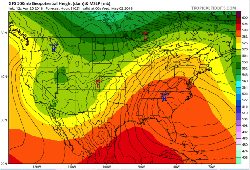
500 mb heights indicate ridging over the eastern portion of the country, suggesting fair skies and warm weather.
The Dailies
Tonight: Showers will taper off late, and patchy fog will develop late. Lows in the low 50s.
Thursday: Mostly sunny skies, becoming mostly cloudy by the evening. Highs in the 60s.
Friday: Chance for rain in the afternoon, ending late night. Highs in the upper 50s and low 60s.
Saturday: Overcast. Chance for an isolated shower or two. Highs in the 60s.
Sunday: Chance for a shower in the morning. Otherwise clearing skies by the afternoon. Highs in the upper 50s and low 60s.
Monday: Sunny. Highs in the 60s.
Tuesday: Sunny. Highs in the 70s.
Wednesday: Mostly sunny. Highs in the upper 70s.
Thursday: Partly cloudy. Highs in the 70s.
Enjoy your week!
-LD
