Good evening from SCW!
Post-Tropical Storm Florence, after battering Virginia and the Carolinas with torrential rainfall and strong winds, is now heading towards Connecticut, with the leading edge of the system almost on our doorstep. Luckily, the storm has since weakened significantly since it began its trip north, but there is still a chance for some significant rainfall tomorrow, especially in northern sections of the state, and flash flooding is certainly possible.
Tuesday
Flash Flood Watches are in effect for the northern four counties.
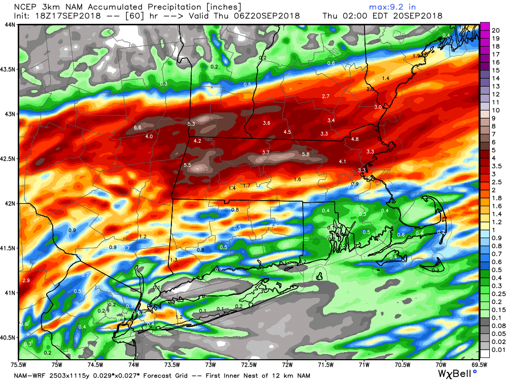
Tomorrow’s going to be a wet day as the remnants of Florence bring heavy rain to the region. More widespread bands of rain move in overnight and last into the morning hours, with the afternoon being more convective in nature as a cold front moves in. Some thunderstorms are likely in this band, and there is an isolated risk of a tornado given the strong forcing present. Otherwise, the main threat is heavy rain, and given the extremely saturated column, I would not be surprised to see some brief torrential downpours that could trigger some flash flooding, especially in northern portions of the state that will be closer to the axis of the heaviest rain (likely in MA or into southern VT/NH). As far as rainfall totals go, the models are generally in good consensus for about an inch of rain across most of the state, with higher totals in the northern areas and potentially lower totals right along the shoreline. Of course, this is all subject to the whims of convection; it only takes a few minutes of a tropical downpour to tack on quite a bit to the totals.
Here’s a look at total QPF on the high-res NAM. Notice the high location variance; this is due to the convective nature of the system and the opportunity for isolated high totals.
Post-Tropical Storm Florence, after battering Virginia and the Carolinas with torrential rainfall and strong winds, is now heading towards Connecticut, with the leading edge of the system almost on our doorstep. Luckily, the storm has since weakened significantly since it began its trip north, but there is still a chance for some significant rainfall tomorrow, especially in northern sections of the state, and flash flooding is certainly possible.
Tuesday
Flash Flood Watches are in effect for the northern four counties.
Tomorrow’s going to be a wet day as the remnants of Florence bring heavy rain to the region. More widespread bands of rain move in overnight and last into the morning hours, with the afternoon being more convective in nature as a cold front moves in. Some thunderstorms are likely in this band, and there is an isolated risk of a tornado given the strong forcing present. Otherwise, the main threat is heavy rain, and given the extremely saturated column, I would not be surprised to see some brief torrential downpours that could trigger some flash flooding, especially in northern portions of the state that will be closer to the axis of the heaviest rain (likely in MA or into southern VT/NH). As far as rainfall totals go, the models are generally in good consensus for about an inch of rain across most of the state, with higher totals in the northern areas and potentially lower totals right along the shoreline. Of course, this is all subject to the whims of convection; it only takes a few minutes of a tropical downpour to tack on quite a bit to the totals.
Here’s a look at total QPF on the high-res NAM. Notice the high location variance; this is due to the convective nature of the system and the opportunity for isolated high totals.
Temps tomorrow will be warm, but a bit cooler than today; highs generally will range through the 70s with very high humidity.
Wednesday-Thursday
Cold front sweeps across the region Tuesday evening and brings much improved weather for midweek. Normal to slightly below normal temps and low humidity is expected, with partly cloudy skies on Wednesday giving way to sunshine for Thursday. Should see highs in the 60s to lower 70s both days, with lows in the mid to upper 50s. Dry forecast aside from some widely scattered showers on Wednesday morning as Florence exits.
Friday-Sunday
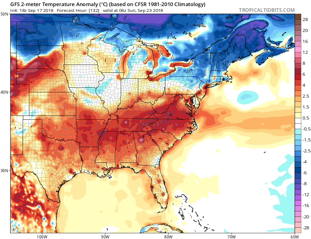
Tricky forecast for your weekend as Connecticut is on the boundary between colder arctic air to our north and warm tropical air to the south. Guidance keeps flipping which side of the boundary we end up on, which will greatly impact our sensible weather. This image from the GFS does a good job at showing what’s going on; notice the well below normal anomalies to our north compared to the well above normal anomalies to our south. We’re generally stuck in the middle, a bit on the cooler side of normal, but a relatively small shift in the placement of the features would result in a notably different outcome for us.
Wednesday-Thursday
Cold front sweeps across the region Tuesday evening and brings much improved weather for midweek. Normal to slightly below normal temps and low humidity is expected, with partly cloudy skies on Wednesday giving way to sunshine for Thursday. Should see highs in the 60s to lower 70s both days, with lows in the mid to upper 50s. Dry forecast aside from some widely scattered showers on Wednesday morning as Florence exits.
Friday-Sunday
Tricky forecast for your weekend as Connecticut is on the boundary between colder arctic air to our north and warm tropical air to the south. Guidance keeps flipping which side of the boundary we end up on, which will greatly impact our sensible weather. This image from the GFS does a good job at showing what’s going on; notice the well below normal anomalies to our north compared to the well above normal anomalies to our south. We’re generally stuck in the middle, a bit on the cooler side of normal, but a relatively small shift in the placement of the features would result in a notably different outcome for us.
Highest confidence portion of the forecast is a warmup for Friday as a storm rolls up the Ohio Valley and into the great lakes, putting us squarely in the warm sector and providing a brief return to muggy conditions. Highs in the mid to upper 70s are likely, with dewpoints in the upper 60s to near 70. Thankfully, this is short-lived, as a cold front behind the storm puts us back into the cold sector by mid-day Saturday. As of now, guidance generally agrees that most of the precipitation from this system passes to our north, with only some scattered showers Friday night or Saturday morning as the tail of the cold front comes through, but still plenty of potential for this to shift and bring some steadier precip to the area on Friday.
What happens after that depends on which model interpretation ends up winning out, but the consensus argues for a mostly dry weekend with normal to slightly below normal temps. Highs in the upper 60s to lower 70s and lows in the 50s seem like reasonable numbers to run with for now, with the caveat that these could change significantly (most likely upwards) depending on the eventual track of Friday’s system. Next system approaches for Sunday evening into Monday, this looks like a stripe of overrunning which could bring some rain to the area. Chance pops for now on that one until we get a bit closer.
A final note; we’re starting to see the seasonal transition into a more winter-like pattern as the jet stream begins to move south and increase in speed. You can see the cold starting to form in Canada on the models and it’s only a matter of time until it starts to bleed south. Although it might not feel like it yet, winter is coming – my skis are ready! We’ll start to speculate on winter in a couple of weeks, with a winter forecast coming in early November. Stay tuned!
The Dailies
Tuesday: Rain, with thunderstorms possible in the afternoon. Highs in the mid to upper 70s. Chance of precipitation is 100%.
Wednesday: A chance of showers in the morning, otherwise, partly cloudy, with highs in the upper 60s. Chance of precipitation is 30%.
Thursday: Sunny, with highs in the lower 70s.
Friday: A chance of showers, otherwise, partly sunny, with highs in the upper 70s to lower 80s. Chance of precipitation is 30%.
Saturday: A slight chance of showers, otherwise, partly sunny, with highs in the upper 60s to lower 70s. Chance of precipitation is 20%.
Sunday: Mostly sunny, with highs in the mid to upper 60s.
Have a great night and thank you for reading SCW!
-SA
