The weather will largely turn hotter, beginning Saturday and culminating on Monday, when heat indices will exceed 100 degrees in some areas. However, after that, there could be more storms, with a possibility for severe weather by Tuesday.
Currently: A beautiful summer day in progress, as a cold front has made it all the way to Virginia Beach this afternoon. Yet another cold front is over Northern New York State and Northern New England. This front clears the region tonight, ushering in even more refreshing weather for tomorrow. Behind that front, however, a Bermuda high will take over and gradually heat things up.
Tonight: Clear skies, low dew points, and lightening winds should allow temperatures to fall efficiently tonight. Therefore, I'll go a few degrees cooler than guidance. Low temperatures will be in the 50s, with even a reading or two below 50 possible in the NW Hills.
Tomorrow: A blend of guidance will work well, a spectacular day, with plenty of sun and a few passing clouds from time to time. High temperatures should generally be a couple of degrees above 70. A few locations in the NW hills may stay in the 60s!
Tomorrow Night/Saturday: Sunshine abounds on Saturday, with a warming trend. In general, guidance looks decent, but with a warming air mass, I'll go with the warmer end of guidance. This yields highs in the low 80s.
Long Term: Sunday and beyond: For Sunday, the Bermuda High becomes more assertive and temperatures will continue to rise. So we go a few degrees warmer than Saturday, now into the middle 80s.
Monday will be the hottest day of the period, as temperatures really soar. In addition, the humidity will increase on a strong return flow. The warmest locations should see heat indices reach 100 degrees. It could become dangerous for those who work outside, so take appropriate cautions... stay hydrated, wear light-colored, loose-fitting clothing, and try not to do too many strenuous activities. Also avoid prolonged exposure to the sun, if it all possible. I don't really want to go "all out" on temperatures just yet, but it is time to consider going a degree or so above guidance, so I'll call for highs in the low 90s across the state. Some areas along the immediate SE coast may stay in the 80s, but sea breeze influence should be limited.
On Tuesday, a strong cold front approaches. Although I do not like to try to say that any given day is a shoo-in for widespread severe weather on Day 5, since this is Connecticut and not Kansas, one has to like the setup by simply taking a glance at what I see. CAPE (Convective Available Potential Energy) should be off the charts, given dew point temperatures, and at this point, the timing of the line of storms (late afternoon) looks just about perfect. So while I do not want to jump in and say that there will be a severe weather outbreak on Tuesday, it looks as good as it can from this point in time. It is also too early to look at any other convective indices at this point, since they'll probably change significantly anyway, but when I reassess this on Monday afternoon, I'll be able to get a better grasp of everything. Temperatures on Tuesday will be tricky, due to the timing of the storm. 850 temperatures are the same as Monday, if not a tick warmer. However, the dew point temperatures will be a bit higher, which usually translates to surface temperatures being a degree or two lower. In addition, if someone is forecasting clouds and thunderstorms to arrive in the afternoon, we also have to be consistent, and forecast our temperatures accordingly. So I'll call for temperatures a few degrees cooler than those of Monday. This is still a coupe of degrees warmer than guidance, since guidance at this time generally gets tempered one way or another by climatology. So I'll call for highs within a few degrees of 90 on Tuesday.
For Wednesday and Thursday, dew points should be much lower, so it should feel much better outside. The W-NW wind directions suggests a good setup for downsloping type weather. Model guidance temperatures typically do not handle this very well, especially 6-7 days out. Therefore, I raised guidance temperatures by 3-5 degrees. This yields highs of 80-85 degrees on Wednesday and mid to upper 80s on Thursday.
As of this writing, the long range looks to feature temperatures at or just a bit above normal. The storminess should probably take a break for a while, but my hunch is we turn very stormy again before month's end. Now, let's take a look at some of the weather systems that will affect our region. Since there is really only one significant precipitation event during this period, I'll add a map (and explanation) for Monday's surface temperatures, since that is a significant weather event this week. So, let's take a look at Monday's temperatures first.
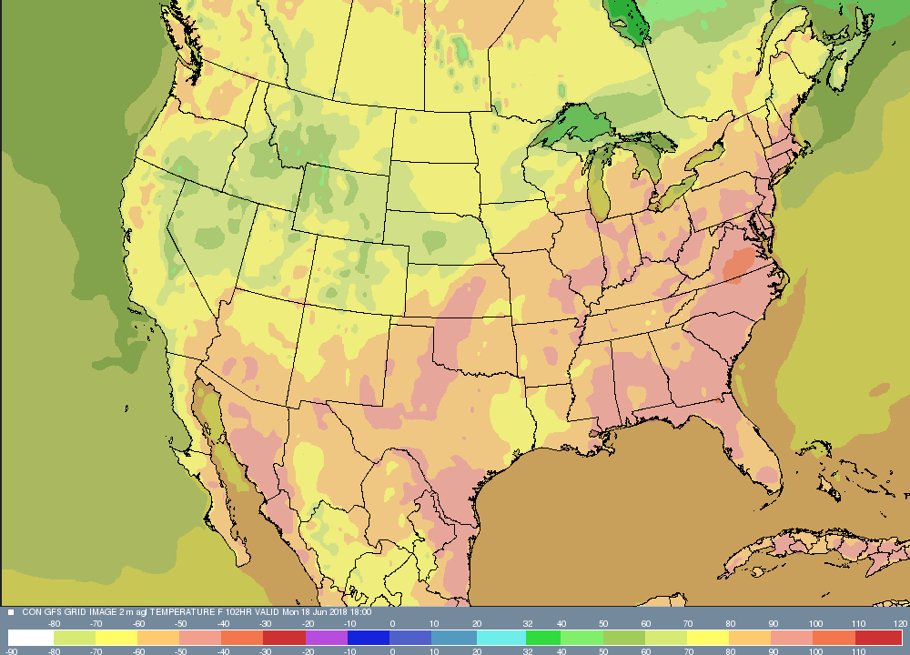
This map is only valid 1 PM on Monday, so temperatures actually have another couple hours to rise. Notice how the 90s extend all the way into Maine! And yes, those are 100s in Virginia! Next, let's take a look at the cold front and line of thunderstorms slated to affect the state on Tuesday.
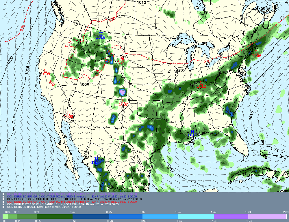
You can trace the front on this map by following the 570 thickness line. Notice the front is basically along I 90 just before dusk. Squall lines typically precede frontal passages by about 100-150 miles. This timing is nearly perfect- coincident with the heating of the day- for Connecticut to see strong to severe thunderstorms. So that's one factor that is favorable, and we'll examine it more closely on Monday. Have a great weekend and see everyone on Monday!
-GP!
-GP!
