Southern Connecticut Weather
  • Home
  • Forecaster Discussion
  • SCW Social Media Hub
  • SCW Facebook
  • About Us/Contact Us

Forecaster Discussion--1/26/20

1/26/2020

Comments

 
Good afternoon from SCW! 

The storm we discussed last week came and went quickly with heavy rain for much of the state yesterday. Today has proven to be a nice day, with temperatures in the 40s across the state and fair conditions. The average high temperature today in Hartford should be 35.

​The week ahead looks fairly similar to the last, with high pressure dominating during the work week and all attention focused on another potentially strong storm system during the weekend. 

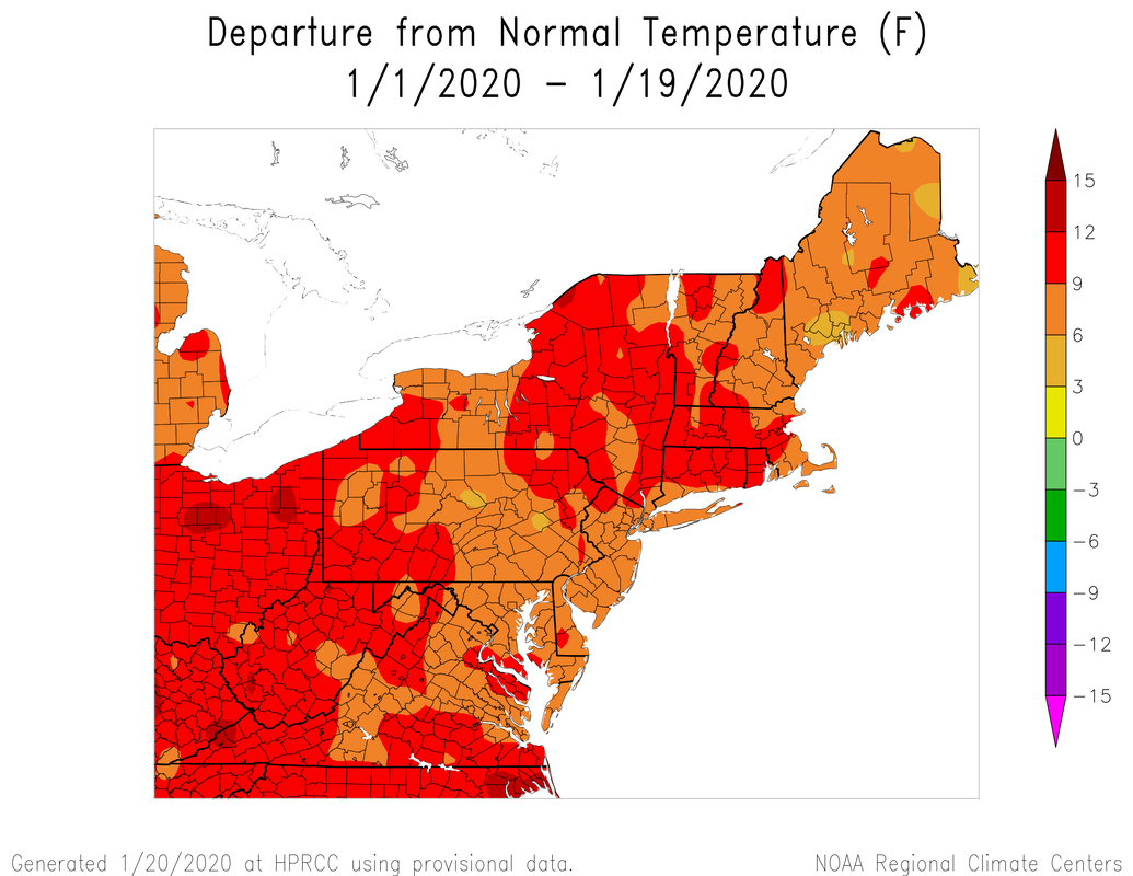
This is the last week of what has been a very warm January. At this point in the season, average high temperatures begin to rise (slowly at first), and we are gaining over two minutes of daylight each day! For winter haters, this is great news. The march toward Spring is slowly beginning.

For those winter lovers out there, however, we've seen how quickly things can change. February is actually our snowiest month historically, and the last few years have brought our biggest snow events in February and March. Current indications continue to signal that we may see another one of these backloaded winters. Hard to do much worse than this January! 

Five of the last seven winters had more snow in February than January (Hartford area)

The last three winters brought ten inches or more of snowfall (Hartford area)
Picture
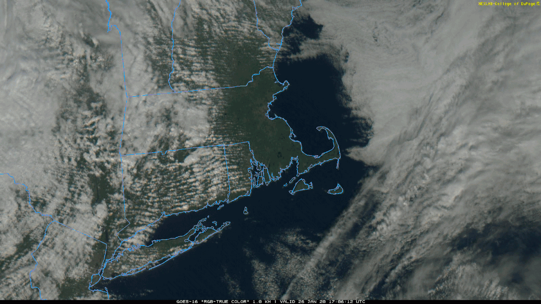
GOES-16 image from earlier showing fair conditions across Connecticut. More of the same is expected this week. 

​Monday-Friday
There's no real need to go over each day separately because they should be substantially similar! A ridge of high pressure will dominate the week, bringing quiet conditions and warmer than normal daytime temperatures.

Monday will likely be the warmest day of the week, with temperatures similar to today--rising through the 40s for everyone. Tuesday through Friday look a little colder with highs in the upper 30s to low 40s, and may be a bit clearer once high pressure is overhead. Thursday could be a sneaky below normal temperature day, but nothing outrageous. By Friday evening, we should begin to see things cloud up a bit in advance of our possible weekend storm. 
Picture
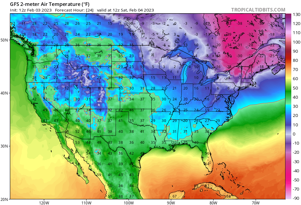
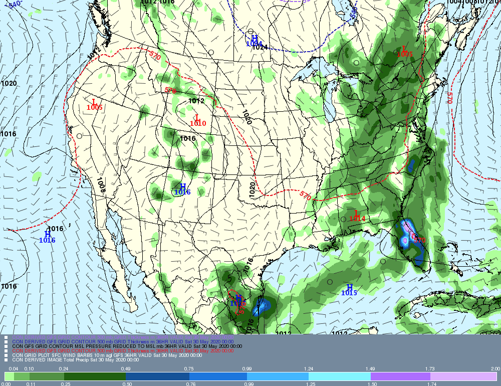
Above is the 12z GFS, depicting what is on all the guidance--a quiet work week as high pressure scoots over the region. Note the gathering storm at the end of the run. I stopped the animation there because there is significant uncertainty after Friday. 

Saturday-Sunday
If there's any activity, it is likely to happen during Super Bowl weekend. Much like last week, there is a strong signal that a significant storm will develop in the south near the end of the week. Just like last week, there is no clear path yet for knowing whether that storm will impact Connecticut and/or whether this is another rain event or a winter weather event.

This is another complicated setup, and it may be Wednesday at the earliest when we have a better idea of what will happen. Currently, the overall upper level pattern favors some type of coastal storm development, but that could easily force things offshore to bring us nothing. I think the main takeaway at this time is that next weekend could be active. I would not cancel or modify any plans at this time.

Stay tuned. 
Picture
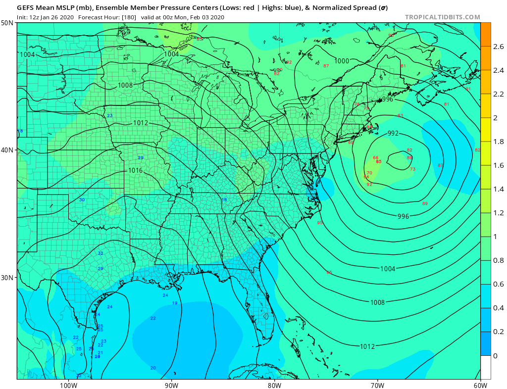
Above is a GEFS depiction of the possibilities for the weekend potential. Note that there are a number of strong low pressures in there, but many of them are well offshore. This is something to watch with a casual eye. 

The Dailies
Monday: Partly cloudy and seasonably warm. Highs in the low to mid 40s. 

Tuesday: Partly cloudy. Highs in the upper 30s to low 40s. 

Wednesday: Mostly sunny. Highs in the upper 30s to low 40s. 

Thursday: Mostly sunny. Highs in the low to mid 30s. 

Friday: Partly sunny. Highs in the upper 30s to low 40s. 

Saturday: Mostly cloudy with a chance of rain/snow. Highs in the low to mid 30s. Chance of precipitation 30%. 

Sunday: Mostly cloudy with a chance of rain/snow. Highs in the low to mid 30s. Chance of precipitation 30%. 

A​s always, please like, share, and interact with us on our social media--on Facebook to share our discussions, and follow us on Twitter @southernctwx to retweet our posts. Hit the buttons below to join.

Thank you for reading SCW. 

-DB​ 
Follow @SouthernCTWX
Comments

...A STORMY PATTERN SET TO TAKE HOLD OVER THE AREA, UNCERTAINTY LOOMS REGARDING TEMPERATURES...

1/23/2020

Comments


Disc: a very active pattern is set to take hold on the area.  One of the biggest questions will be temperatures, for two reasons.  First, for much of the forecast period, the air mass is marginal, so we'd need a perfect track and a strong storm to get snow,.  Secondly, there is uncertainty regarding temperatures in the long term, because of model disagreement.

Currently: High pressure extended from near the NJ shore to off of Nova Scotia.  This high pressure area was keeping fair weather over the area.  Since the high is about to move offshore, a gradual warming trend has commenced.

Tonight: Guidance is in good agreement.  With a bit of a battle between radiational cooling and warm air advection, I prefer taking a guidance split.  There will be a wide range of temperatures tonight, due to radiational cooling.  Lows will range from the upper teens up north to near 30 along the south coast. 

Tomorrow: With an onshore flow developing and becoming deep layered ahead of our next storm as the day wears on, I prefer the cooler guidance (GFS based) for tomorrow's highs.  Expect highs in the mid to upper 40s, with the cooler readings along the south coast.  Otherwise, we'll call it a mix of sun and clouds and a nice day for the time of year.

Tomorrow night/Sat: A large storm system will affect the area.  This storm is loaded with moisture.  However, because of its track generally along the Delaware River watershed, I would not expect frozen precipitation in the area.  The time of precipitation arrival will range from mid-morning west, to mid-afternoon east.  Because precipitation will be arriving after temperatures have had a chance to warm up some after overnight lows, I do not even expect any freezing rain in the coldest locations.  Rain could come down heavy at times.  With partially-frozen ground, flooding could become a concern.  As far as temperatures, I'll split the difference between the cooler NAM and warmer GFS temperatures, but with a hedge toward the warmer numbers, as I don't see any real cold air damming.  Therefore, expect highs generally in the low 40s, with a few mid 40s possible along the I 91 corridor.  Rain ends from west to east from 6PM to midnight Saturday night.

Long Term (Sunday and beyond): For Sunday, a few snow flurries are possible as some moisture rotates around the departing low.  However, since no measurable precipitation is expected, I prefer to leave them out of the forecast for now.  As usual, in a cold air advection regime, guidance looks too warm.  However, this time the cold air advection is weak.  So I'll only chop a couple degrees off the guidance.  Expect high temperatures generally in the 40 to 45 degree range.

The rest of the long term looks quiet, at least as far as the range of this operational forecast.  The only threat of any precipitation is a passing flurry or two Monday. Again, with no measurable precipitation expected, I can leave it out of the forecast.  

As far as temperatures for the long term, expect a trend toward colder weather as time moves on.

Monday: low 40s
Tuesday: low 40s, maybe staying in the upper 30s NW hills.
Wednesday: mid to upper 30s
Thursday: low 30s.

Looking into the long range, it appears the pattern is set to feature multiple waves in a suddenly very stormy pattern.  The air mass may be just cold enough for wintry weather if the storms are strong enough and follow a perfect track.  Some of the modeling is now advertising the idea that troughiness near Alaska may begin to break down in the long term, which would break off pieces of the very cold air that is over that region, and point them at our area.  However, there is still not much agreement yet, so I do not want to bite too hard on any one solution yet.

Now, let's take a graphical look at systems slated to affect the area in the upcoming week.  Note that since there really is only one system and no extreme temperatures, I will only post one map today- from Saturday, to show that storm.  You can see from this mao, that there are two lows- one near Cleveland, and one near Philadelphia, and very hevay rain moving into the region. Although the storm may not last that long, there is a lot of moisture getting ready to affect the area!

​

Comments

Forecaster Discussion--1/20/20

1/20/2020

Comments

 
Good evening from SCW. 

As mentioned in prior forecasts, the long awaited pattern change has finally taken place. The weekend saw our first winter weather event in quite some time, and the start of this week has been quite cold. Many remained below freezing today, and that will likely continue for inland areas through tomorrow.

The sustainability of this more wintry pattern however, is in flux. Previously, we thought that we'd see a bit of a relaxation after this initial burst, followed by a reload of the pattern. That is looking more tenuous as we end the month.

We've had plenty of winters that were backloaded, so while it's not ideal, I am not too concerned at this time that this winter will end up being a total dud. There are still signals that February isn't a total disaster for winter lovers. 

Turning toward this week--the theme during the workweek is quiet. The main thing to discuss is the weekend, which may feature a significant storm.  
Picture
Above is the month to date departure in temperature. In past years, we've saved our blowtorches for December. Not this winter. The outrageous image above is courtesy of the Northeast Regional Climate Center. 

​Tuesday-Wednesday
The cold will remain for the next two days. Tomorrow looks very cold with most below freezing all day. Conditions will be nice as high pressure remains in place. Wednesday will be when we begin to see more moderation in the temperature, with many reaching the mid to upper 30s. 

Thursday-Friday
As upper level ridging traverses the region, we will see continued moderation in temperatures on Thursday and Friday. Conditions should remain quiet, and with highs in the low to mid 40s, it might feel pretty good outside! All eyes will then turn toward the weekend. 
Picture
Above: A 12z European Ensemble panel showing the upper level pattern this weekend. Note how there is ridging/higher heights in Canada while an area of low pressure is nearby. That's the kind of setup that could bring an interesting setup. 

Saturday-Sunday
There is a great deal of uncertainty with the weekend. As mentioned above, the ensembles of the European model, and the other guidance, has been highlighting this period for a few days. With transient (short-term) blocking we will likely see an upper level low traverse the US. As it gets closer to the East Coast, we may see enough cold hang on for a winter weather event. 

The issue is that this is a storm that could easily be rain for most if not all of the state if the low is poorly timed or the track is such that we get warm air flooding the state rather than cold. In fact, I currently favor a mostly rain event for much of the southern portion of the state.

However, there is a long way to go, and indications are that there is higher end potential for a big snowfall, especially in the hilly sections of NW CT. Stay tuned. For those tracking closely, don't even bother looking at the operational runs of the GFS and Euro too much yet--ensemble guidance leads the way in these kind of complex setups. 
Picture
Above: Euro Ensemble MSLP anomalies. A storm is coming, but track will make a big difference as to whether this is a widespread winter weather event or another rain event. 

The Dailies
Tuesday: Mostly sunny and cold. Highs in the upper 20s to low 30s. 

Wednesday: Mostly sunny and seasonably cold. Highs in the mid to upper 30s. 

Thursday: Mostly sunny and warmer. Highs in the low to mid 40s. 

Friday: Mostly sunny early with increasing clouds late. Highs in the mid 40s. 

Saturday: Mostly cloudy with a chance of rain and/or snow. Highs in the mid 30s. Chance of precipitation 60%

Sunday: Mostly cloudy with a chance of rain changing to snow. Highs in the mid 30s. Chance of precipitation 50%

Monday: Mostly sunny, breezy and cold. Highs in the low to mid 30s. 

A​s always, please like, share, and interact with us on our social media--on Facebook to share our discussions, and follow us on Twitter @southernctwx to retweet our posts. Hit the buttons below to join.

Thank you for reading SCW. 

-DB​ 
Comments

Final Call Snowmap and Discussion for 1/18/2020

1/17/2020

Comments

 
​Good evening from SCW!
 
Our first winter event in a while is on its way for tomorrow afternoon through the wee hours of Sunday, with accumulating snow statewide transitioning to rain Saturday night as temps warm. Overall, we’re expecting a moderate event, with mainly advisory levels of accumulation, but there’s some uncertainty on either end of the spectrum – should we see a colder than modeled solution play out, we could approach warning level totals in some areas, while dry air or a weaker/warmer storm could lead to an event that’s more wet than white.
 
Model Discussion
 
Here’s a look at the setup on the hires NAM. 
Picture
​The low goes well to our west and brings warm air into the state, but there is a good deal of precipitation out ahead of the warmth that’s running into the cold airmass that’s in place now. How strong that initial band comes in will likely be a big determinant in how much snow we get; a strong first band like the NAM shows will quickly saturate the column (minimizing the amount of QPF we lose to virga) and also help keep temps down, while a weaker solution will result in a good chunk of the QPF lost to dry air and also a quicker changeover. Eventually, warmer air moves in from the south and starts flipping areas over to rain from south to north, but at the same time, a dryslot moves in as the main low passes to our north and precipitation becomes very light or shuts off entirely.
 
The other main determinant will be how long the cold air can hold on at the surface before the warmer air moving in from the SW wins out. Generally, a more intense system will hold cold air in longer while still bringing more QPF, and as the changeover period is during the height of the precipitation, even a variation of an hour or two will make a big difference in snow totals. To show this, here is surface temps at 8 PM tomorrow from the Euro and the GFS as well as the final snowmaps from these models. I wouldn’t take either of the snowmaps as gospel, but the point is clear – a small shift towards colder temps has a big impact in overall snow totals. Generally, the guidance has been trending a bit stronger and a bit colder, and so we’re a bit more confident in higher totals than we were yesterday.
​Guidance is generally in good agreement, so with no major outliers, I took a consensus blend of the models for the forecast and adjusted it a bit based on analogs and a gut feeling to drag things a little warmer and therefore a bit quicker of a changeover, but any adjustments were minor.
 
Forecast and Timing
 
Here’s our forecast map for this event. 
Picture
I expect the highest totals in the NW hills, and I expect totals to decrease as you head SE, with the largest drop-off being along the immediate SE coastline where warm air will arrive first. I think the biggest wildcards here are the NE hills and SWCT. I could see both overperforming for different reasons (the NE hills because of cold air holding longer and SWCT for a quicker onset of precipitation) but for now I’m not confident enough in either scenario to boost up totals. With QPF being generally in the 1/3”-1/2” range and shaving a little off for rain, I’m comfortable with totals for most of the state in the 2-4” range, with some isolated 5” spots where heavy bands form. In the NW hills, I think cold air will last the longest, so I went with a 3-6” range, and along the far SE coast the combination of delayed arrival of precip and being the first to change over to rain will mean lower totals in the 1-3” range.
 
Look for snow to overspread the state starting in the mid afternoon, with western areas seeing snow as early as 2 PM ish while eastern areas will need to wait until around dark. Changeover to rain from south to north begins around dinnertime, but by midnight or so we’ll see a dryslot move in and shut off most precipitation. Could see some mixed rain and snow showers around through the overnight into the early morning hours, but I think by sunrise any lingering precip should be gone.
 
Impacts
 
Snowfall Accumulation--Moderate
This is an advisory level event for most and the impacts reflect that. Could call it low impact in the SE corner, but 2-3” ish is still plowable and I think that’s a legitimate possibility there. We have Winter Weather Advisories out from the NWS for all of the state except northern Litchfield County where there is a Winter Storm Warning.

Snowfall Rate--High
Although snowfall accumulations will be relatively low, I do expect a period of moderate to heavy snow centered around dinnertime or so. That will make road conditions an issue, and I exepct things to go downhill fast as heavy precipitation moves in. Plan your travels early in the day if you can!
 
Icing--None
This should be a rain/snow event and no icing is expected.

Wind--Low
I do not expect much wind with this storm. 

Power Outages--Low
I don’t think snow will be all that wet, and amounts aren’t enough to do serious damage given the banal winds. 

Timing--Moderate
Luckily it’s a weekend and there’s no school/work to worry about, but if you’ve got plans Saturday afternoon or evening you should definitely be aware of the forecast and be ready to modify your travels if necessary.

Road Conditions—Moderate/High
The totals won’t be all that crazy, but a quick period of heavy snow is all it takes to gum up the roads. The crews will be out there doing what they do best, and I expect that major roadways will still be moving (albeit slowly), but secondary and tertiary roads will be challenging. Sunday is the much better travel day of the weekend if you can swing it.
​
All in all, a pretty textbook moderate event for the state. We’ll have live updates on our social platforms as needed tomorrow, and please send us your reports on Facebook, Twitter, or by email – we really appreciate them. Thanks for reading SCW, enjoy the snow, and have a great long weekend!
-SA
Comments

..WINDS OF CHANGE USHERING IN CHANGE BACK TO WINTER WEATHER ACROSS THE STATE...

1/16/2020

Comments

 
Disc: Wind advisories are in effect throughout the state, as gusts up to 50 MPH will be possible for the rest of the day.  This wind is ushering in much colder air and a much more wintry pattern for the foreseeable future.  This all begins with much colder weather tomorrow and a widespread wintry threat on Saturday.

Currently: Cold front is now well East of the area with bombing low pressure located over Boston.  This low, combined with arriving high pressure, is responsible for the very windy weather across the state today.

Tonight: Temperatures plummet as cold air races in.  Winds diminish after 10 PM or so, but it will still be windy all night and even into tomorrow morning, with gusts in the 35 to 40 MPH range.  But the threat for 50 MPH winds will end.  Guidance temperatures are generally accepted, with lows ranging from the upper teens to near 20..  There should not be too much variation tonight, given strong winds and a well-mixed atmosphere.

Tomorrow: Much colder.  Winds gradually diminish, although it will likely still be windy for the first hal of the day, but not as windy as today.  Guidance is in remarkably great agreement.  An old forecasting convention says that when all three sets of guidance are within a degree of each other, run with it, because it's hard to do better.  So in this case, that's what I'll do! Highs should range 25-30.

Tomorrow Night/Sat: We'll radiate well tomorrow night with clear skies.  However, clouds do increase, so for this moment, I prefer to go a couple degrees above guidance.  Even so, this yields very cold low temperatures, from 5 to 15 degrees or so.  Along the SE Coast, toward GON, temperatures will probably stay in the upper teens.  More on that area in a minute...

Saturday is the period of interest here.  Snow should develop across the entire state during the mid to late afternoon hours.  This is not a long-duration event.  The entire event is really only about six hours.  With a southerly flow, the immediate south coast will probably change to rain.  In these areas, expect a coating to two inches of snow, with the two inches more likely in SW CT and the coating more likely in SE CT.  For most of the rest of the state, snow will fall briefly heavily. By the time it gets warm enough to rain, most of the precipitation will have ended.  Expect generally two to four inches in these areas, with the four most likely in elevated areas.  I am not very concerned about sleet.  Model text soundings are solidly uniform, so there is no warm layer there.  In addition, an old meteorological trick is to check the thicknesses.  Sometimes, if thicknesses get very high, even though all text layers appear below freezing, it's a warning sign that there's a warm layer in there somewhere, probably at a layer that text does not "see".  However, thicknesses are low, so this is not a concern,  I do have a concern for lingering freezing drizzle along and north of I 84 Saturday night.  Once forcing vacates the area, ice nuclei cannot form to support snow flakes and light rain droplets fall.  North of 84, temperatures should remain below freezing, so freezing drizzle will be possible.

One other quick note: Due to the fast moving nature of this system, as well as the very dry air to start off, this is not a high QPF event.  Therefore, I do not expect any large totals, even in areas that stay all snow.

Long Term (Sunday through next Thursday): The main highlight of the long term is prolonged cold weather.  

For Sunday, Breezy with clearing skies behind the storm.  Expect wind gusts to 30 MPH most of the day, with cold air advection.  Could be one of those days where temps spike up for a couple hours after the sun comes out, then level off or slowly fall. As is typically the case, I don't think the GFS MOS is doing a good job with cold air advection.   Therefore, I'll shave off 3-5 degrees.  Expect highs generally 35 to 40 degrees, perhaps a bit cooler in the NW hills.

On Monday, winter cold.  Should be mostly precipitation-free, but an afternoon flurry cannot be ruled out, especially up north as another cold front moves through.  With the cold air mass in place, I'll shop a couple degrees off guidance and call for highs within a couple degrees of the freezing mark.

For Tuesday, with cold air advection and fresh Arctic air in place, I'll do my usual trick of cutting 3-5 degrees off temperature guidance.  Expect high temperatures only around 20 degrees.  In addition, it will be breezy, so it will feel even colder! Again, I am not expecting any precipitation, but an afternoon flurry cannot be ruled out, especially up north.

For Wednesday, temperature guidance looks good, as the air mass settles into the region.  No major modifications have been made to the guidance, except a tweek here or there.  Expect high temperatures only in the low 20s!

Thursday will continue to be very cold.  Once again, temperature guidance looks fine and is accepted.  It should bump up a couple of degrees, as the core of the Arctic air moves east.  Even so, it will still be very cold.  Expect highs in the mid to upper20s.

Looking into the long range, I see no signs of the cold temperature abating as we get into the long range.  In addition, the southern jet stream looks to become increasingly active.  This would generate a stormy pattern to go along with the cold!  This should bring smiles to the faces of winter weather lovers! For those who don't like winter weather, you just had two weeks of spring in January!

Now, let's look at some graphical images of weather systems slated to affect the area in the coming week! Since we only have one real system, I'll post Saturday's snowstorm map, then we'll go into Wednesday morning's low temperatures, as that should be the coldest day of the cold snap, at least until the next cold snap!

This map is valid Saturday around dinner time.  Precipitation, mainly snow, except maybe not right along Long Island Sound, has overspread the state by that time.  It is hard to take any model map perfectly literally.  However, if this map verifies literally, one of the 4" locations might very well be somewhere between Waterbury and the NW Hills.  That would not be inconceivable, as that area generally does the best in this setup anyway.
Picture
This map shows Wednesday morning's low temperatures.  Since this map is just a snapshot valid at dawn, low temperatures usually end up a couple of degrees colder.  This would infer that it is not out of the realm of possibilities that someone in the NW Hills and valleys goes below zero!

​
Picture
Anyway, that's all for now, see you next week, or sooner, if conditions warrant!

-GP!
Comments
<<Previous

    Archives

    April 2023
    March 2023
    February 2023
    January 2023
    December 2022
    November 2022
    October 2022
    September 2022
    August 2022
    July 2022
    June 2022
    May 2022
    April 2022
    March 2022
    February 2022
    January 2022
    December 2021
    November 2021
    October 2021
    September 2021
    August 2021
    July 2021
    June 2021
    May 2021
    April 2021
    March 2021
    February 2021
    January 2021
    December 2020
    November 2020
    October 2020
    September 2020
    August 2020
    July 2020
    June 2020
    May 2020
    April 2020
    March 2020
    February 2020
    January 2020
    December 2019
    November 2019
    October 2019
    September 2019
    August 2019
    July 2019
    June 2019
    May 2019
    April 2019
    March 2019
    February 2019
    January 2019
    December 2018
    November 2018
    October 2018
    September 2018
    August 2018
    July 2018
    June 2018
    May 2018
    April 2018
    March 2018
    February 2018
    January 2018
    December 2017
    November 2017
    October 2017
    September 2017
    August 2017
    July 2017
    June 2017
    May 2017
    April 2017
    March 2017
    February 2017
    January 2017
    December 2016
    November 2016
    October 2016
    September 2016
    August 2016
    July 2016
    June 2016
    May 2016
    April 2016
    March 2016
    February 2016
    January 2016
    December 2015
    November 2015
    October 2015
    September 2015
    August 2015
    June 2015
    May 2015
    April 2015
    March 2015
    February 2015
    January 2015
    December 2014
    November 2014
    October 2014

    Categories

    All
    Tropical Weather
    Winter Forecast

    Authors

    Southern Connecticut Weather is brought to you by Timothy Wrightington Jr. (TW), Spencer Aronstein(SA), Greg Petridis (GP), and Don Bell (DB).

Picture
Copyright Southern Connecticut Weather 2018, all rights reserved. 
For website related inquiries, email us at support@southernconnecticutweather.com

Privacy Policy/Terms of Service