Southern Connecticut Weather
  • Home
  • Forecaster Discussion
  • SCW Social Media Hub
  • SCW Facebook
  • About Us/Contact Us

...SPRINGTIME SLOWLY SETTLING IN ACROSS THE STATE...

3/26/2020

Comments

 
Disc: As the header states, springtime will slowly. but surely settle in across the state over the next few weeks.  As is typical this time of year, a brief bout or two of winter is possible, especially the further north you head.  But ultimately, spring will settle in.

Currently: High pressure near Richmond, VA, is dominating our weather today.  Yesterday's low pressure system that passed south of the area is well out to sea.

Tonight: Temperatures will probably settle close to, but perhaps a bit lower than guidance.  This could be either because of early radiational cooling before clouds move in, or late evaporational cooling, as light rain moves in.  There could be light rain toward morning in far SW CT.  It should be noted that the NAM has nothing, while the GFS has measurable making it to the south coast.  Because yesterday's event, also a southern scraper, was closer to what the GFS printed out than the NAM, I'll go with about an 80% GFS-based solution, so I'll go with chancey pops for Srn Fairfield County only toward dawn.  For temperatures, I'll go with lows right around 40 degrees.

Tomorrow: If there is any measurable rain, it will be along the immediate S coast, think S of the Merritt Pkwy.  It all ends by noon.  Warmer air then moves in.  Because of the potential for clouds to linger, I'll go just a smidge below guidance.  So we'll go with highs in the upper 50s.

Tomorrow Night/Sat: The next wave of low pressure will approach the area.  This one will have a significant amount more rain than its predecessor.  Although light rain is possible at any time, steadier, heavier rain should wait until the 2nd half of Sat, and continue into the night.  I like colder temps for Saturday than guidance is advertising, only because we usually stay colder than normal in this situation, both due to evaporational cooling and some in-situ CAD that usually develops.  For these reasons, I'll take the coldest (NAM) guidance and then subtract 3 degrees from that.  Highs should be near 50, but most places should probably end up on the lower end of that range.

Long Term (Sun and beyond): There is lots of uncertainty in this period, unfortunately.  This can be seen by how model solutions change drastically from one run to the next.

First, for Sunday, forecast concerns revolve around how far N the warm front makes it.  I hate to take the "cop-out" solution because realistically, it usually doesn't work out like that, but it is "the course of least regret" with regards to temps, in that the bust potential on either side is lower.  Therefore, we'll run the warm front up to somewhere between the Merritt and I 84 (maybe thinking that the first elevated area can stop the Nwd progress of the front).  The NAM holds the front much further S, not even clearing NYC, but it is very unreliable at this range.  The GFS gets it up to about the Mass Pike, but tends to be overagressive at this range.  So maybe my "preliminary location" won't be that bad after all.  Some of these fronts have a very sharp gradient, so if I am off by only 30 miles (which is very little in medium-range meteorology), some folks will bust.  I will try the best I can here and compromise the GFS and NAM, but go a bit closer to the GFS, given the NAM's unreliability at this range.  This yields highs around 50 degrees, but closer to 55 in the I 91 corridor.

Now the second potential problem is precipitation chances.  Most rain should taper off by dawn.  After that, there's a slight chance of a pop-up shower at any time.  With the cold frontal passage, there could also be a line of showers and thunderstorms late in the day and early in the evening.

For Monday thru Wednesday: An upper level low will affect the region.  This upper level low will send little spokes of energy thru the area, that could produce showers at any time, although the vast majority of these three days should be dry.  As far as temperatures, I'll go 1-3 degrees below guidance all three days, since upper levels are cold, and any time temperatures rise this should lead to the formation of showers.  There may even be a precipitation type question with this.  Anything that falls on Monday is rain.  On Tuesday, there could be a mix with snow or sleet to I 84, and perhaps all the way to the coast on Wednesday.
'
Monday should also see gusty winds to 30-35 MPH.  As for temperatures, look for highs in the mid to upper 50s Monday. upper 40s Tuesday, and only 40 to 45 Wednesday.  

One more note about this period, there is a coastal low modeled to stay well south of the area on Wednesday.  Most modeling is in agreement that this stays to our south.  However, any shift of the upper level low out of the region faster than modeled could lead to this low coming further north than currently modeled, which would result in a rainier and windier solution than currently advertised.  This is NOT currently forecast, but something to watch.

Thursday clears out with nicer weather moving in regardless.   Guidance may be a degree or two too cold, given full sun.  Highs should be 50-55, but could be warmer than that along I 91.

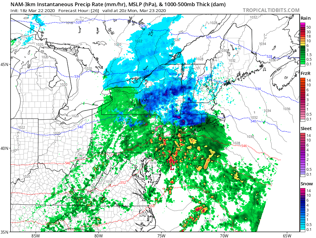
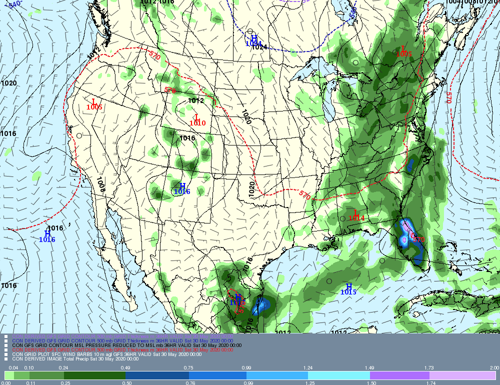
Now, let's take a look at some of the systems slated to affect our area in graphical form.  I will show Saturday's system and Wednesday's potential (squashed) system.  First, for Saturday: look at the swath of rain over NJ and PA, basically along I 80, headed toward the area.  This image is valid late Saturday afternoon.

​
Picture
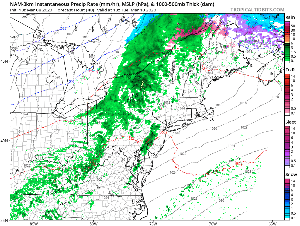
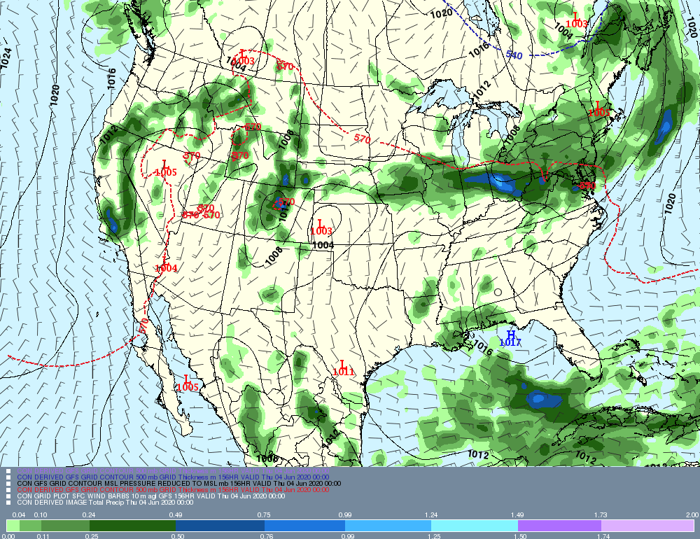
Now, taking a look at the Wednesday potential coastal.  Taking this model run literally, the storm is well south of the area.  However, it does not take much to bring this significantly north.  Keep an eye on this just in case!

​
Picture
Anyway, that's all for now, take care, stay healthy, and see everyone next week!

​-GP!
Comments

Winter attempts to make a comeback this week...after spring officially arrives...

3/22/2020

Comments

 
Good evening from Southern Connecticut Weather. 

It was a beautiful weekend! Hopefully you were able to get outside some and continued to practice good social distancing. Spring officially arrived a few days ago, but the week ahead will have a few wintry precipitation chances for interior areas of the state. It will be an unsettled week. 
Picture
As I have posted fairly frequently, here is the temperature departure for the month of March so far. Hopefully, we're not this much warmer than normal when we get to summer! 

Monday-Tuesday
​Tomorrow looks messy during the afternoon and evening hours. An area of low pressure will develop and slide off the Mid-Atlantic coast, but at the same time, cold air will be retreating. That means that for most in southern Connecticut, this is a nonevent. For inland areas, low elevation areas are unlikely to see significant snow, but elevation areas of Litchfield and Tolland counties should see accumulation snow. Even then, it's not much outside of the higher elevation areas. Snow should begin late morning to early afternoon, and bring a period of snow to most outside of I-95 before changing to rain outside of the elevated areas, and changing to rain for everyone by later in the evening. 

Southern CT should see no accumulation. For inland areas, expect a coating in most places to two inches if lower areas are lucky. There should be 1-3 inches in the hill towns, and maybe a little more if cold air is able to hang on more in the highest elevations closest to the Mass border. Overall it'll be a wintry start to the storm, but no big deal--especially this time of year. 

Tuesday looks beautiful. In the wake of the storm, high pressure will build in. That will be a brief period of quiet as we have another storm moving in later on Wednesday. 
Picture
Above, the high resolution NAM showing a period of moderate snow tomorrow afternoon. 
​
Wednesday-Thursday

This period looks unsettled as well, as another storm system traverses the region. This storm looks to have a little more cold air possibly working with it, so although we are likely to start as rain Wednesday morning, there may be a period of snow during the afternoon and evening hours before another switch to rain. The storm should depart by Thursday morning, and things should begin clearing out. I'm not ready to throw out numbers yet on that, but at this time, that looks like a minor event. ​
Comments

...MORE ACTIVE AND CONTINUED FAST-MOVING PATTERN TO CONTINUE, TEMPERATURES STILL GENERALLY BIASED TO ABOVE NORMAL...

3/12/2020

Comments

 
Disc: Seems like spring sprung early this year and there are no signs of really sustained winter on the way.  Sure, it *COULD* snow, especially at night, for the next month or so, especially across the NW Hills, but chances diminish with every passing day.  All in all, the pattern does look a bit more active, but still biased warm.

Currently: Low pressure was currently over E NC, high pressure was over Quebec.  This is keeping it cloudy and cool today, with a deep-layered marine air mass in place.  As that storm and warm front shift north, expect increasing rain chances with it.

Tonight: Steady rain will generally arrive before dawn west of 91 and south of 84.  North and east of there, it will be more towards dawn.  Non-NAM based statistical guidance would have you believe the rest of the night is dry.  While I am not going to buy the NAM wholeheartedly as there is not nearly enough lift to produce steady rain so early, there already have been sprinkles across NNJ and as the deep-layered marine flow continues into the night, drizzle will become more likely, especially along the S coast.  So I will forecast spotty drizzle and even an isolated shower for the first half of the night, with the highest chances south, then introduce steadier rain from SW to NE very late at night.  Temperatures will be tricky.  We are currently running below statistical guidance everywhere, and since that high pressure system is still holding on, I will go a few degrees below temperature guidance, as temperatures should be able to fall for a few hours, as long as that high holds on.  Temperatures may very well begin to rise toward morning.   I'll go with fairly uniform lows, around 40 degrees, as the south coast may cool more effectively than other areas with drizzle and wind off the cold Long Island Sound.

Tomorrow: Heavy rain is likely in the morning, with rain ending in most areas by early afternoon.  Temperatures will be very tricky, dependent upon how far north the warm front makes it.  It is a very strong warm front, so there will be a sharp thermal gradient and a small error in warm frontal placement could result in a large error in temperatures.  I feel the cooler NAM guidance is more correct, and will ride it.  For example, the GFS has 70 degrees in Manhattan tomorrow afternoon, and I don't think that is going to happen.  So we'll go with highs within a few degrees of 60.  Two more issues are present tomorrow.  First, there is a chance of thunderstorms in the morning.  Based on soundings, there is enough instability to mention thunderstorms in the SW 1/2 of the state (basically south of 84 and west of 91).  Nothing severe, just thunder and lightning imbedded within the rain.  The second issue will be strong and gusty winds behind the cold frontal passage, mainly later in the afternoon hours.  Winds will be relatively strong for a few hours, with gusts to 30-35 MPH, but nothing all that impressive.  The GFS has stronger winds, with more instability and warmer temperatures, but since I am ignoring that solution, I toned down the winds a bit.

Tomorrow Night/Sat: Cooler, but still a bit above normal.  (It's amazing how warm we've been that when it's only a few degrees above normal, it feels chilly).  GFS-based guidance tends to struggle when we have cold air advection.  The NAM guidance is closer to reality, but I'll tweak that down a degree or two as well in certain areas.  All in all, sunny and not a bad day.  Highs should be around 50 statewide.  

Long Term: (Sunday and beyond): Generally quiet through this period.  The only system of concern comes right on St Patrick's Day.  Sunday should be a bit warmer than guidance, as it looks sunny and a downsloping type day.  Look for highs in the mid to upper 40s.  Clouds increase Monday and probably a legit chilly day, with high temperatures in the low 40s.

Looking at soundings, Tuesday appears to be generally an all-rain event.  It may start as some sleet and/or wet snow, and possibly even an hour or two of decent snow falling N of 84.   However, even there temperatures are pretty warm at the sfc, so any accumulations would be minimal and limited to grassy and cold surfaces.  Rain should fall all day, and should be moderate at times, but nothing extremely heavy.  I am going to go 4-7 degrees lower than all guidance on Tuesday.  Contrary to tomorrow, where you have a strong low passing very near the area, Tuesday's storm is much weaker and further west.  Therefore, that does not look like a situation where the warm front will blast through.  So look for highs generally in the upper 40s.  Somewhere along I 91 may touch 50, but no need to get too cute with temps this far out.

Wednesday and Thursday should be tranquil.  Guidance looks reasonable, and to be bluntly honest, it isn't such a big deal if it's a degree or two warmer or cooler in this regime.  So there is no reason to go crazy over temperatures those two days.  I only made a few minor tweaks, given microclimates in the state.  Highs should be in the low 50s Wednesday and near 50 Thursday.  Thursday is one of those days where valleys along I 91 could be a couple degrees warmer, for whatever this is worth.

Looking into the long range, we may actually get into a below normal temperature pattern for the last week of March.  As far as winter weather/snow lovers go, it may very well be a case of "too little, too late", especially near the coast, but we'll have to wait and see on that.

Now,let's look at a couple of systems slated to affect our area this week.  Since there really are only two systems, we'll look at tomorrow and Tuesday.   This map is a little earlier than when the real "action" gets into our state, but you can see the heavy rain back over NY, PA, and NJ, getting ready to move into our area.

​
Picture
The next image, valid Tuesday, shows a general light rain over the area.  Note how far away the low is.  This is why I don't think the warm front will blast through the area.

Anyway, that's all for now... See you again next week!

-GP!
Comments

Forecaster Discussion--3/8/20

3/8/2020

Comments

 
Good evening from SCW! 

What a weekend we had! After another possible winter storm whiffed, we were treated with sunny and relatively warm conditions. The week ahead looks relatively quiet, as we get a real taste of spring tomorrow and continued warmer than normal conditions through the week. As GP mentioned, our general springtime weather pattern continues. Spring ahead! 
Picture
Much like January and February, we're looking at a March that is warmer than normal so far. 

Monday
Tomorrow is easily the pick of the week. We will see high pressure move offshore and the resulting flow will bring much warmer than normal conditions. Inland areas may very well see temperatures tickle 70! Be sure to get outside during lunchtime to enjoy! 

Tuesday-Thursday
Tuesday looks warm as well, but it should come in a few degrees cooler. Most of the day looks dry, but by the later part of the afternoon we should see showers move into the state in advance of a cold front. We shouldn't see a lot of rain fall, and most of it should fall during the evening and overnight hours. We should return to dry conditions during the daylight hours of Wednesday and see slightly cooler (albeit still warm for this time of year) conditions. 

Thursday is looking like a decent day with dry conditions in advance of our next potential rainmaker. 
Picture
High resolution NAM depiction of showers Tuesday into early Wednesday. Note that this model run has some showers starting earlier in the afternoon. 

Friday-Sunday
Friday looks like the most unsettled day of the week, as we have a more robust period of rain possible. Friday looks like an umbrella day, but we move on pretty quickly and early indications are that next weekend looks nice! 

The Dailies
Monday: Mostly sunny and warm. Highs in the mid to upper 60s. Some spots may reach 70!

Tuesday: Increasing clouds and showers later in the day/evening. Highs in the low to mid 60s. Chance of rain 50%. 

Wednesday: Early showers followed by decreasing clouds early and partly cloudy conditions. Highs in the low to mid 50s.  
 
Thursday: Partly cloudy. Highs in the low to mid 50s. 

Friday: Mostly cloudy with rain showers. Highs in the low to mid 50s. Chance of rain 60%.
 
Saturday: Mostly sunny. Highs in the upper 40s to low 50s. 

Sunday: Mostly sunny. Highs in the upper 40s to low 50s. 

A​s always, please like, share, and interact with us on our social media--on Facebook to share our discussions, and follow us on Twitter @southernctwx to retweet our posts. Hit the buttons below to join.

Thank you for reading SCW. 

-DB​ 
Comments

...LITTLE TASTES OF WINTER ARE POSSIBLE OVER THE NEXT COUPLE WEEKS, BUT ALL IN ALL, A SPRING-LIKE PATTERN MAINTAINS HOLD ON THE AREA...

3/5/2020

Comments

 
Disc: A general spring-like weather pattern will remain entrenched over the area.  There could be little pieces of winter that move in from time to time, one later tomorrow and maybe a couple next week, but overall, we remain in a general springtime weather pattern.

Currently: Cold front from last night is all the way down by VA Beach.  High pressure is near KIAD, providing the area with a fair, sunny day.

Tonight: Generally clear.  Clouds could increase later at night.  Generally going close to the cooler guidance sets, as I do expect decent radiational cooling conditions.  Lows should range from the mid 20s to the mid 30s.

Tomorrow: Clouds increase.  Sfc low press stays way offshore.  However, models are in fair agreemnt that a "Norlun trough" like feature will throw moisture back across a portion of CT.  Right now, it seems like the highest chances of precip will be across SW CT, as the trough axis seems to favor CNJ to WCT.  However, models generally don't have a good handle on these types of systems until the last minute.  Pcpn type should be mainly snow, esp if it comes down hard enough, given cold upper levels.  However, sfc temps should remain abv freezing.  Therefore, any accumulations should be on grassy sfcs.  And I will not use a standard 10:1 snow to water ratio.   The snow to water ratio should be more like 5:1.  Therefore, any accumulations would be an inch or less, and generally south of 84 and west of 91, or south and west of Waterbury.  The best window for precip timing looks to be between mid afternoon and midnight.  Temp guidance appears way too warm, given the setup aloft, so I'll go with highs in the low 40s, about 4-7 degrees cooler than guidance.

After the precip ends tomorrow night, skies should clear pretty quickly with high pressure building in.  Any slushy snowcover will melt within an hour of sunrise on Saturday, as the combo of strong March sun and quickly warming temps goes to work.  Temp guidance is in decent agreement.  I'll go with the slightly cooler NAM temps, but there isn't all that much difference anyway.  Look for highs generally between 40-45, though a few spots in the I 91 corridor could exceed 45.

Long Term (Sunday and beyond): Expect fair weather the first two days of the long term, with more unsettled weather thereafter.

For Sunday, i am going a couple degrees warmer than temp guidance, with a warm, downslope flow expected.  Most places should soar into the mid 50s with plenty of sun, but it will be a bit cooler in the NW Hills.

Monday will be even warmer as high pressure books offshore, allowing for a return flow to establish itself.  I could be too low on temps.  I went a degree lower than guidance, only because guidance seems very aggressive.  While it could be right, I like to be cautious at this range, because there could be a couple more clouds or a touch more onshore flow than anticipated.   So for now, I am calling for highs in the upper 50s, although that could be adjusted upward in subsequent forecasts.

A cold front approaches Tuesday.  For now, I prefer to keep most of the daytime dry and not bring precip in until around dark.  The GFS is generating "0.01"s most of the day, but the GFS has a tendency to do that ahead of cold fronts, and in reality, there is no precip in that area.  So I'll take the chance and assume it is showing that bias again.  All in all, I feel guidance is a few degrees too warm on Tuesday.  Even though I am keeping most of the day rain-free, it will still be mostly cloudy and for that reason, I think temps are too warm.  Expect highs in the mid to upper 50s.

The next system to watch is a system developing along the cold front to our south and spreading overrunning moisture into our area Wed night.  Since it comes at night and since the upper levels are cold, the favored precip type here is snow.  However, once again, most of the precip at this time at least, looks to be on the light side, since the sfc low never really explodes.  High temps on Wed should be near 50 and Thurs in the mid to upper 40s, but with the system sliding by at night, temps will slip into the low to mid 30s, so snow is possible then.  

Yet another system could slide near or under the area by Friday, which would produce mainly rain, but also could start out as snow, if today's progs are close to being correct.

The long range looks to feature a warming trend, with generally warmer than normal temps expected.  However, being that it is March, expect fairly frequent shifts in temps, even if the bias is toward warm.  There could be a shot of cold air towards the last week of the month, but that's too far out to get excited about right now.

Now, let's take a look graphically at some systems that could affect the area in the coming week.  First, I'll show tomorrow's NORLUN trough feature, then I'll show Wed night's frontal wave, since those are the two systems that could produce winter weather in our area. As you can see, most of the precip with the NORLUN trough is either over WNJ and EPA or over W LI.  A spoke of moisture may extend into SW CT and they have the best chance of seeing decent precip rates.

​


Picture
Finally, looking at the Wed night system, you can see that the system is to our south and light, overrunning moisture has spread into the area.  It does appear *JUST* cold enough for nocturnal snow, but we'll wait and see!

​
Picture
Anyway, that's all for now! I'll see you again next week! 

​-GP!
Comments
<<Previous

    Archives

    April 2023
    March 2023
    February 2023
    January 2023
    December 2022
    November 2022
    October 2022
    September 2022
    August 2022
    July 2022
    June 2022
    May 2022
    April 2022
    March 2022
    February 2022
    January 2022
    December 2021
    November 2021
    October 2021
    September 2021
    August 2021
    July 2021
    June 2021
    May 2021
    April 2021
    March 2021
    February 2021
    January 2021
    December 2020
    November 2020
    October 2020
    September 2020
    August 2020
    July 2020
    June 2020
    May 2020
    April 2020
    March 2020
    February 2020
    January 2020
    December 2019
    November 2019
    October 2019
    September 2019
    August 2019
    July 2019
    June 2019
    May 2019
    April 2019
    March 2019
    February 2019
    January 2019
    December 2018
    November 2018
    October 2018
    September 2018
    August 2018
    July 2018
    June 2018
    May 2018
    April 2018
    March 2018
    February 2018
    January 2018
    December 2017
    November 2017
    October 2017
    September 2017
    August 2017
    July 2017
    June 2017
    May 2017
    April 2017
    March 2017
    February 2017
    January 2017
    December 2016
    November 2016
    October 2016
    September 2016
    August 2016
    July 2016
    June 2016
    May 2016
    April 2016
    March 2016
    February 2016
    January 2016
    December 2015
    November 2015
    October 2015
    September 2015
    August 2015
    June 2015
    May 2015
    April 2015
    March 2015
    February 2015
    January 2015
    December 2014
    November 2014
    October 2014

    Categories

    All
    Tropical Weather
    Winter Forecast

    Authors

    Southern Connecticut Weather is brought to you by Timothy Wrightington Jr. (TW), Spencer Aronstein(SA), Greg Petridis (GP), and Don Bell (DB).

Picture
Copyright Southern Connecticut Weather 2018, all rights reserved. 
For website related inquiries, email us at support@southernconnecticutweather.com

Privacy Policy/Terms of Service