Southern Connecticut Weather
  • Home
  • Forecaster Discussion
  • SCW Social Media Hub
  • SCW Facebook
  • About Us/Contact Us

SCW Period of Interest declared for Monday as heat wave likely to break with a bang...

7/24/2022

Comments

 
Good evening from Southern Connecticut Weather. 

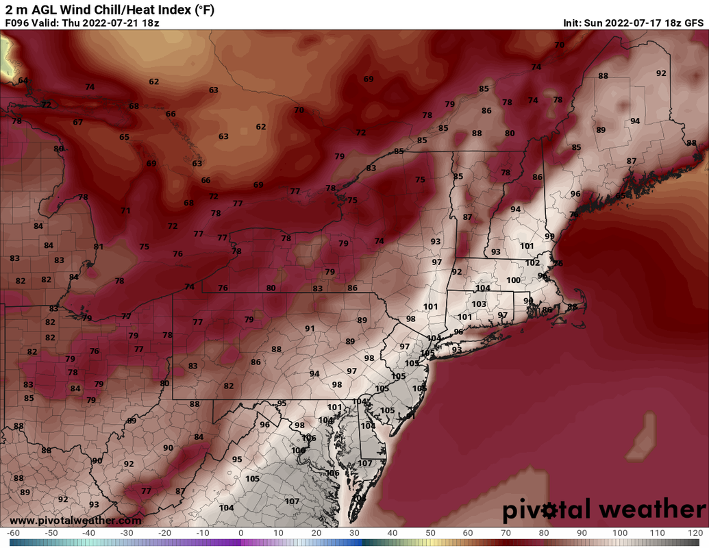
​After six days, the official heat wave is ending for many. Tomorrow will bring more humid conditions but lower temperatures, and it looks like only a few inland spots have a real shot at reaching 90 degrees and extending this heat wave to a full week, which is uncommon in New England. 

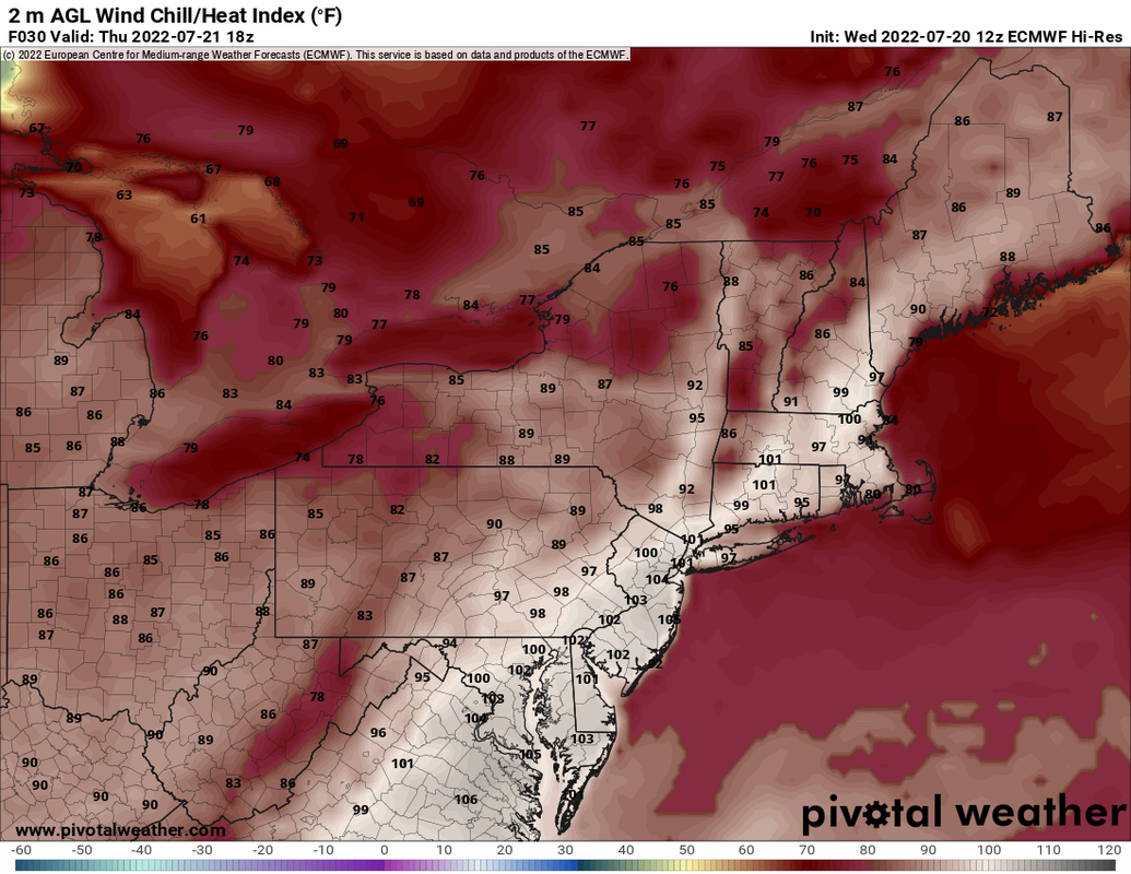
Tomorrow will still be an oppressive day with heat indices in the 90s, and with legitimate potential for severe weather tomorrow we are declaring a SCW Period of Interest, which means we have growing confidence in a period of significant weather. Rather than post the standard weekly forecast, this discussion will mostly focus on tomorrow. 
Picture
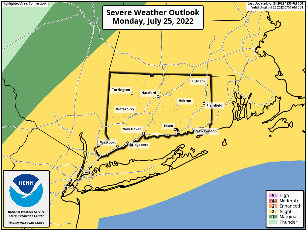
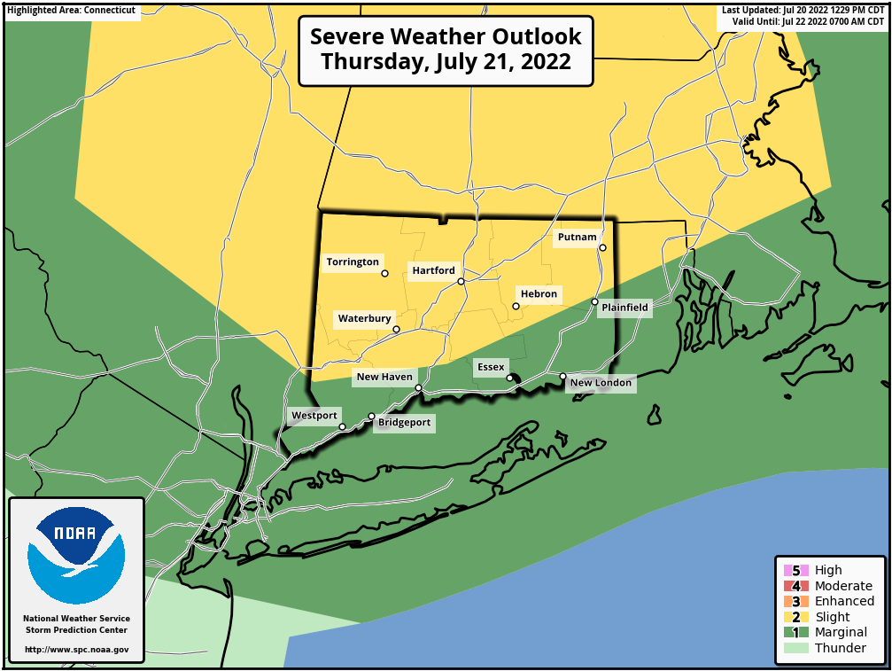
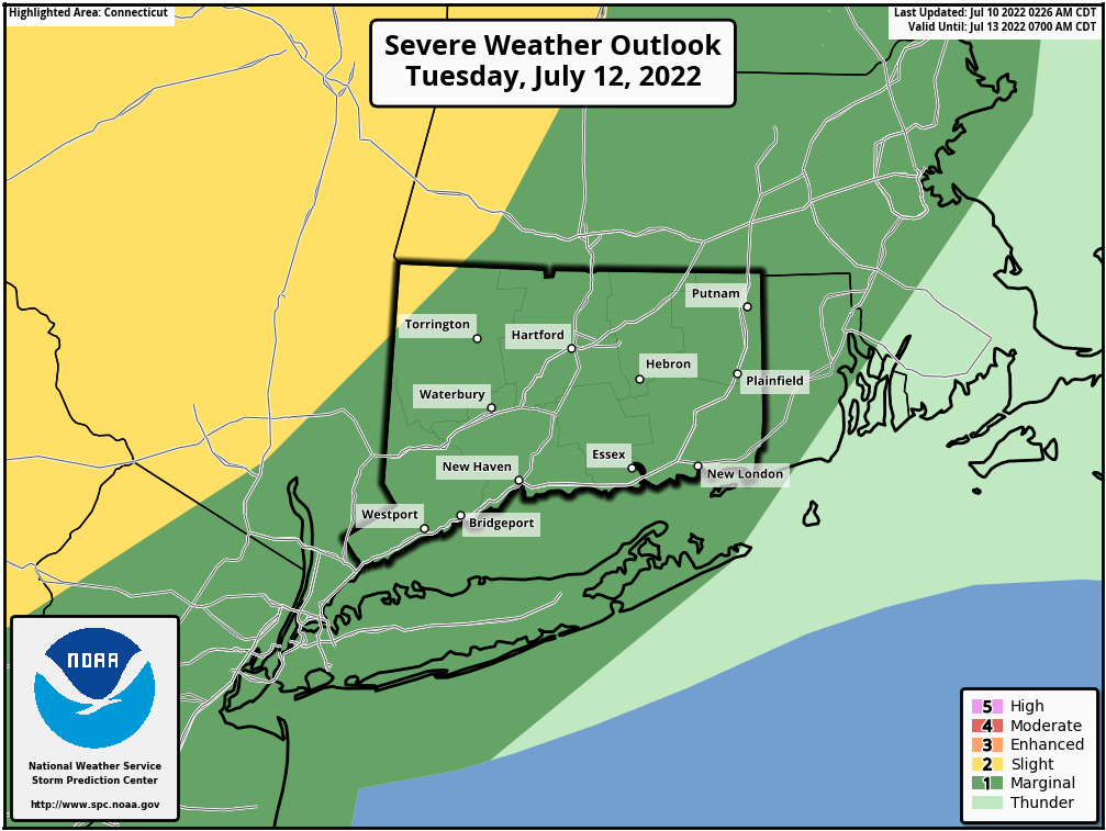
Above: the SPC outlook for tomorrow, which has all of CT under a slight risk. There is a chance that parts of New England get upgraded to an enhanced risk, depending on the environmental conditions tomorrow and confidence of severe weather by the SPC. 

The Overview
You can already feel it outside this evening. The temperatures have come down, but humidity is rising. A lot. Think back to past heat waves: many of them broke with a front that brought strong storms. Although many won't hit 90 tomorrow, the airmass is still oppressive, and the change ushered in by the coming front will end the heat wave for all.

I will readily admit that I am still a little biased by Thursday, even though that was generally a good forecast. The worst of the severe weather was to our north as forecast and although we had severe storms bring damage to part of western CT, which is usually the favored area, despite a seemingly great environment the storms fizzled once they got to central CT. This was likely due to a left splitting supercell to the south of CT robbing the cells in CT of the ingredients needed to continue propagating east. 

Every forecast is different however, and looking at the potential environment tomorrow, we have to take note at what's on paper. 

The Ingredients
First, moisture. This one is an easy forecast as we already see the moisture building into the state in the form of high dew points. Tomorrow will be oppressive, and that's good for thunderstorm development. Even if the severe threat were to fall apart tomorrow, heavy rain would still be fairly likely, providing some needed rainfall to virtually every part of the state. 

Second, shear. Another part of the forecast that seems easy, as we anticipate an uncommon level of wind shear on the order of 40 to 50+ kts according to the National Weather Service. That's more than enough for some organized storms. This also leads to heightened potential for low level spin, or higher helicity. That will open the door for supercells or rotating storms within a developing line in advance of the front. 

Third, lift. There will be a front and a jet streak moving in. Plenty of lift means plenty of activity likely tomorrow. This is one of those times where it looks like everyone gets at least some rain. 

Fourth, instability. If there's a place where the severe weather potential has a fly in the ointment, it's here. It's tricky too. We're likely to see some instability--it's hard to not have a couple hundred J/Kg of CAPE given the environment mentioned above, but with activity tonight and potential showers tomorrow morning in advance of the main line of storms we may have cloud debris that keeps us from getting sunny enough to really maximize instability. 

That said, the high resolution models like the NAM, HRRR, and HREF (which is essentially an ensemble of convective models) all have some fairly significant destabilization taking place. The result is an active day statewide with scattered severe storms possible. 
Picture
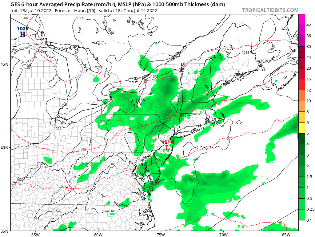
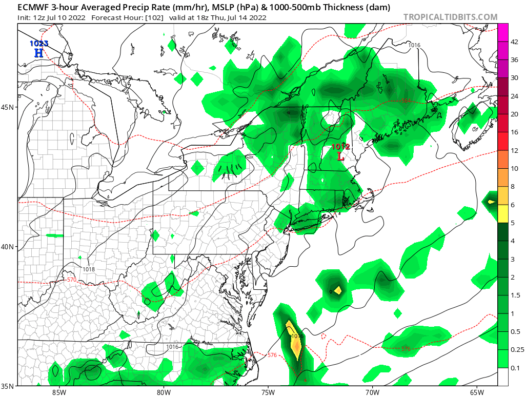
Top image: 18z high resolution NAM depicting morning showers giving way to clearing and then a strong line of storms between 5-10pm. 

Bottom image: 00z HRRR depicting similar morning showers giving way to clearing and then a broken line of storms between approximately 3pm and 1am. 

Neither will be spot on, but they help in narrowing the envelope of possibilities. The global models, for what it's worth, are more muted. 
Picture
The Forecast
Ok, so what's the forecast?

Expect a hot and oppressively humid day tomorrow with highs in the mid to upper 80s at the shore and upper 80s to low 90s inland. Expect dew points in the low to mid 70s. We may see some clouds and showers early, followed by potential clearing in the early afternoon. How much clearing is critical to instability, but even without maximizing potential there, the other ingredients are enough for another active day in New England even if it's not severe weather. 

Storms will begin to develop regionally in the early afternoon and while there may be some pop up storms in CT during that time, the main activity is likely to come from a line of storms forming to our northwest in New York and diving into the state. 

Currently, I think everyone gets some rain as this should be a large line. We probably see widespread strong (non-severe) storms. Severe storms are probably scattered--as is usually the case not everyone sees truly severe weather but if you get it you know it. 

Folks should be prepared for the main batch of storms between 2pm and 10pm from NW to SE, but I think this window will change (and narrow) a bit tomorrow as we see what's evolving. 

As is usually the case with severe potential, we need to see what the environment is in the morning and as things are developing. Currently the main hazard is wind, but there is a chance of hail and an isolated tornado. 

After the front, we go back to lower humidity levels and nice conditions Tuesday and Wednesday before the humidity creeps back up to end the week and into the weekend. No other heat waves in sight, though. 

Keep an eye to the sky and radar tomorrow. SCW will be here with updates as conditions warrant. 

​A​s always, please like, share, and interact with us on our social media--on Facebook to share our discussions, and follow us on Twitter @southernctwx to retweet our posts. Hit the buttons below to join.

Thank you for reading SCW. 
​
-DB
Follow @SouthernCTWX
Comments

Heat wave becomes official tomorrow as "big heat" signal grows...severe weather risk tomorrow and potentially Sunday as extended heat wave ends...

7/20/2022

Comments

 
Good evening from Southern Connecticut Weather. 

Today was day two of what will be an extended heat wave in Connecticut. Inland areas saw temperatures in the mid to upper 90s and even the shoreline saw highs in the low to mid 90s with heat indices touching 100 at times. Bradley Airport (BDL) had a high of 97. Hartford (HFD) had a high of 97. Bridgeport (BDR) had a high of 94. 

The active weather week continues tomorrow with even higher heat indices and a threat of severe thunderstorms during the afternoon.
Picture
Above: 12z Euro depiction of the heat index tomorrow afternoon in CT. Tomorrow will actually feel worse due to the increased humidity. In fact, the National Weather Service (NWS) has a maximum heat index of 105 in Hartford tomorrow and Sunday. Image courtesy of Pivotal Weather. 

Thursday
I alluded to it on Sunday, but now I have enough confidence to declare tomorrow a SCW Period of Interest.

First, the heat. A heat advisory will be in effect for all of CT through the day. Tomorrow will almost certainly be the third consecutive day of 90+ in inland CT, making our first heat wave of the year official. It'll actually be a few degrees cooler with additional cloud cover, but the tradeoff will be higher humidity. Dew points should be in the upper 60s to low 70s, with most having dew points in the 70s. It'll be hot and oppressively humid, and heat indices will be over 100 for many tomorrow. Use heat safe practices tomorrow regardless of whether you are outside or inside. 

Second, the storms. The Storm Prediction Center (SPC) has kept most of CT in a slight risk for tomorrow. Beginning late morning we should see activity pop up in the region as a front moves through during the day. There will be instability, ample moisture, and sufficient shear. The hangup may be lapse rates and the relative lack of height falls per the NWS, but the ingredients are there otherwise, and the high resolution guidance has activity in CT tomorrow afternoon. 

I still think the greatest severe weather threat is to our north, but we can't rule out strong to severe thunderstorms tomorrow afternoon centered between about 3-8pm. Wind would be the greatest threat, but an isolated tornado and hail are possible too. We'll be watching, and we encourage you to keep an eye to the sky and radar. 
Picture
Above: SPC outlook for tomorrow. 

Friday-Saturday
In the wake of the front, it'll still be hot, but the humidity should come down briefly as we get northwest flow advecting in drier air. That said, highs are expected to be in the low to mid 90s on Friday and back to the mid to upper 90s on Saturday. There may be some thunderstorms on Friday afternoon, but we're not expecting any widespread severe weather threat at this time. Saturday should be clear. 

Sunday
Originally, it looked like the peak of the heat would be centered Wednesday and Thursday, but the guidance has continued to extend and increase the big heat (95+) signal for the weekend as the ridging that is baking much of the US expands and and Atlantic ridge allows for favorable advection of heat and humidity. As a result, the hottest day of the entire period looks like Sunday now. Expect more heat advisories if not an excessive heat watch/warning. 
Picture
Above is the 18z GFS depiction of Sunday afternoon. It's aggressive with 100 degree temperatures from NE Mass through North Carolina, but the Euro isn't too far behind. Image courtesy of Tropical Tidbits.

Ensemble guidance has inland temperatures in the upper 90s on Sunday, and operational guidance has been flirting with 100 degree temperatures inland. I'm a little skeptical of 100 being possible with dew points in the upper 60s to low 70s. That would produce a rare extreme heat day. Usually, the higher the air temperature the lower the dew point. It is difficult to achieve 100 degrees in this region, and like inefficient mixing of humidity, cloud cover, cooler morning temperatures, and wind direction could keep highs 98-99 rather than 100-101 again. We'll keep watching the trend for Sunday. It's going to be hot no matter what. 


Another front is expected to be in the area Sunday, with big heat, moisture, and shear present again, a severe weather threat is possible. It's far out and we don't know the timing of the front yet, which will be critical. It is something to watch, however. This is another potential period of interest, but let's wait a little longer before declaring it. 

The heat wave is likely to break after this front, with temperatures next week looking seasonably warm. 

​A​s always, please like, share, and interact with us on our social media--on Facebook to share our discussions, and follow us on Twitter @southernctwx to retweet our posts. Hit the buttons below to join.

Thank you for reading SCW. 
​
-DB
Follow @SouthernCTWX
Comments

Active week ahead as we watch building heat and severe weather potential...

7/17/2022

Comments

 
Good evening from Southern Connecticut Weather. 

It was another warm and nice weekend! Yesterday some locations received some much needed rain, but for most, the dry pattern continues. The much of the state continues to be in moderate drought. 

Unfortunately for those that have loved our summer of low humidity and seasonable temperatures, deep summer returns with a vengeance. With it, comes more rainfall chances which is great, but there are two opportunities for storms and they may have a severe weather threat with them. 

Let's dive in. 
Picture
Above: European model ensemble mean of temperatures on Wednesday. This is a strong signal for heat statewide and Thursday may be even hotter. 

Monday
Tomorrow is our best rain chance of the week, and the setup is favorable for heavy rainfall as high precipitable water levels and a potent system passing to the north will allow the forcing and moisture to bring rain. However, where we see the best rain is unclear as much of it will be convective. Basically, it'll depend on where you are.

I think the best chance of meaningful rain is in NW CT but again, anyone could see periods of moderate to heavy rain. Temperatures will be lower because of the cloud cover, and that is key to a conditional severe weather threat. We are going to have moisture (so expect high dew points), forcing, and shear in place, but it's unclear whether we get enough instability for storms.

Although the SPC doesn't have CT in a meaningful severe risk zone, we should watch. With significant low level shear there could be a tornado threat in New England. For CT, I think the best chance of strong to severe thunderstorms will be in northern and western sections, but again, this is all conditional on instability tomorrow. 
Picture
Above: the 18z high resolution NAM showing thunderstorms tomorrow morning and afternoon, mostly concentrated in NW CT. The depiction above won't be exact, but it helps to show where the best risk is. Note that in SE CT, the NAM tries to keep most rain away. I don't think that'll happen. 
Tuesday-Wednesday
Monday will be cooler than normal due to the rain and clouds, but after that, the heat is on. Tuesday may be the start of an extended interior heatwave. It's crazy to have to say this for the first time on July 17, but a heat wave is defined as three consecutive days of 90+ temperatures.

We should get that and then some.

While the Central US bakes with an astounding heat dome over it, we will see a more peak summer regime settle into place here, though nothing close to the potentially historic heat out west. Parts of Oklahoma may see temperatures over 110! 

Tuesday and Wednesday will be hot. The heat will build each day, and to a lesser extent, humidity should too. The dew points after Monday's system should drop for Tuesday, but begin building on Wednesday and becoming oppressive on Thursday. You can see the building heat in the GFS depiction below. Image courtesy of Tropical Tidbits. 
Picture
Thursday
I am tempted to declare Thursday a SCW Period of Interest due to heat and potential for severe storms, but I am going to hold off for now because I don't have higher confidence in either yet. For now, Thursday looks like it may be the hottest day of the summer so far. We will see oppressive humidity with dew points in the upper 60s to low 70s, and high temperatures in the mid to upper 90s. If this materializes, we should see air quality alerts and a heat advisory for interior CT. 

In addition, while we are likely to see a front pass through the region that would normally bring a chance of thunderstorms, the NWS has also stated there's a possibility of an elevated mixed layer (EML) in the region that day. If these ingredients combine the result would be a very active day in parts of New England. This is definitely worth watching and we'll be on top of it. 
Picture
Above: the latest (18z) GFS showing the heat index Thursday afternoon. I think at the very least we should expect heat indices near 100 on Thursday and possibly higher depending on the dew point. 

Saturday-Sunday
Even though the front passes on Friday, the heat will continue through the weekend, with highs in the upper 80s to low 90s, possibly extending the heat wave. We should see more general afternoon thunderstorm chances Sunday, with lower humidity Saturday/higher humidity Sunday. Nothing to cancel next weekend's plans over. 

Tropical Update
Meanwhile in the tropics, the Atlantic is quiet. There are no visible threats for development during the forecast period. This will change, however. I expect things to begin picking up very late July/early August. 

The Dailies
Monday: Mostly cloudy with rain showers and thunderstorms. Rain may be heavy at times. Some storms may be severe. Highs in the upper 70s to low 80s. Chance of rain 60%. 

Tuesday: Mostly sunny, breezy, and hot. Highs in the upper 80s to low 90s. 

Wednesday: Mostly sunny and hot. Highs in the low to mid 90s. 

Thursday: Hazy, hot, and humid. Highs in the mid to upper 90s with higher heat indices. Chance of storms in the afternoon, some of which may be severe. Chance of rain 40%. 

Friday: Mostly sunny and hot. Highs in the upper 80s to low 90s. 

Saturday: Partly sunny and hot. Highs in the upper 80s to low 90s. 

Sunday: Partly sunny and hot with a chance of storms. Highs in the upper 80s to low 90s. Chance of rain 30%. 

​A​s always, please like, share, and interact with us on our social media--on Facebook to share our discussions, and follow us on Twitter @southernctwx to retweet our posts. Hit the buttons below to join.

Thank you for reading SCW. 
​
-DB
Follow @SouthernCTWX
Comments

Forecaster Discussion--7/10/22

7/10/2022

Comments

 
Good evening from Southern Connecticut Weather. 

It is another spectacular night across Connecticut! Although it has been dry, especially across central and eastern Connecticut, it's hard to have an issue with the summer so far. We've seen long stretches of sunny, warm, and low humidity weather that have made outdoor activities possible without turning into a puddle. 

That will change a bit this week. We will see the humidity turn up along with the temperature. The thing that won't change is the lack of opportunities for meaningful rainfall. 

​Let's dive in.
Picture
Above: The Northeast Regional Climate Center (NRCC) plot of precipitation departures from normal in the last 60 days. During this period, the state has seen much less rainfall than normal. For this reason, much of the state is in a moderate drought. 

Monday
Tomorrow is when we start turning up the heat and humidity. It won't be too bad, as temperatures won't be that much higher than today, but the warmer temps and slight increase in humidity will be noticeable on a southwest flow. Overall, it's not a terrible day, as we will see continued dry and sunny conditions. 

Tuesday
Tuesday is the most meaningful chance we see right now for rainfall during the forecast period. It will be hot and humid ahead of an advancing front, and the heat index will become a factor. Air temperatures will be in the upper 80s to low 90s. The National Weather Service may issue heat advisories as heat indices may end up in the mid 90s for at least central CT. 

Most of the day should be dry. A slight risk is centered to the NW of the state because the timing of the showers and storms will not work for widespread severe thunderstorms here.

Right now, I think we see scattered showers and thunderstorms during the evening hours. The recent trend has been toward a drier frontal passage, so I won't be giving the rain chance here high odds. While I won't rule out a severe thunderstorm, given the current timing I think any severe weather is isolated. We'll continue to watch in case things change in the next 24-36 hours. 
Picture
Above: Storm Prediction Center (SPC) outlook for Tuesday. Although part of NW CT is in the slight risk, I currently think Tuesday does not bring anything other than an isolated severe storm risk. 
​Wednesday
The middle of the week may start out cloudy if the front is slow to depart, but high pressure is likely to build in gradually and clear things out once again. That won't change the temperature outlook though, as I expect highs to reach the upper 80s to low 90s again. Humidity should be coming down a bit. 

Thursday-Friday
The end of the work week will continue to be warm, but I think we see the humidity continue to drop during this period. Once again, it looks dry. The GFS tries to spin up a weak non-tropical low off the coast on Thursday, but I am not buying at this time. The Euro tries something similar, but right now I think high pressure dominates. We'll be watching. I will put in low odds for now. 
Picture
Picture
Saturday-Sunday
The weekend looks fine at this time. We will be watching whether we see some activity along another front on Sunday, but for now, I lean drier. Temperatures look seasonable both days, and as we get closer to the second half of the month, that means quite warm. 

The Dailies
Monday: Mostly sunny and warm. Highs in the mid to upper 80s. 

Tuesday: Partly sunny, hot, and humid. Chance of showers and thunderstorms late. Highs in the upper 80s to low 90s. Chance of rain 40%. 

Wednesday: Decreasing clouds and hot. Highs in the upper 80s to low 90s. 

Thursday: Partly cloudy with a chance of showers. Highs in the low to mid 80s. Chance of rain 20%. 

Friday: Mostly sunny. Highs in the low to mid 80s. 

Saturday: Mostly sunny. Highs in the mid to upper 80s. 

Sunday: Mostly sunny with a chance of showers later in the day. Highs in the mid to upper 80s. Chance of rain 20%. 
Finally, in a new SCW feature, I want to take time to do a quick tropical update at the end of my Forecaster Discussions. 

SCW Tropical Update
Picture
While the Atlantic Basin has been quiet, we always have to watch what I call the "Homebrew region" in the Gulf of Mexico, Southeast US coast, and western Caribbean.

​Usually, even when the broader basin is quiet or the overall environment is unfavorable, as it is now, something can sneak in along a stalled cold front, offshore thunderstorm complex, or weak wave that managed to cross the Atlantic. 

That's what we have here, as the National Hurricane Center (NHC) gives 30% odds for an area of low pressure to develop along a decaying front in the next 5 day in the shaded yellow (lemon) area. The guidance has had a mixed signal on development chances for this one, but if you are interested in tropical generally this is worth a casual eye. 
 
There is nothing that anyone in CT needs to be concerned about. 

A​s always, please like, share, and interact with us on our social media--on Facebook to share our discussions, and follow us on Twitter @southernctwx to retweet our posts. Hit the buttons below to join.

Thank you for reading SCW. 
​
-DB
Follow @SouthernCTWX
Comments

2022 Atlantic Hurricane Season Overview: Season Forecast, Tracking Tropical 101, & Hurricane Preparedness

7/8/2022

Comments

 
Good evening from Southern Connecticut Weather. 

As many of you know, I am all about tropical.

As long as I can remember, I have been most fascinated by the complexity, unpredictability, and power of tropical cyclones. The first tropical experience I remember is Hurricane Floyd in 1999, which passed right over my house in central Connecticut as a tropical storm. I remember being glued to the television and satellite as it rolled up the coast, and the power going out in my elementary school as the trees swayed in the wind. 

Of course, not all tropical systems are as "gentle" to Connecticut (and elsewhere) as a weakened tropical storm. Tropical systems, even if they are not major hurricanes, can cause catastrophic destruction over hundreds or even thousands of square miles. Hurricanes have, even in recent years, been responsible for thousands of deaths, mostly from flooding and the aftermath of the storm. As we have seen firsthand, Connecticut is not immune from tropical impacts, as the state received direct impacts from a highly unusual four systems last season: Fred (remnants), Tropical Storm Elsa, Tropical Storm Henri, and after the worst hurricane impact last year in the US--the remnants of Major Hurricane Ida. 

Connecticut has not seen a landfalling hurricane since Hurricane Gloria in 1985. It has not seen a major (Category 3+) hurricane since 1954. The closest hurricane approach was Bob, in 1991. 

It has become a common phrase, but we are long overdue for a hurricane strike in New England. Although we have had a number of storms like Irene, Sandy, and Isaias that have helped cull the overgrown and dead trees in CT, it may not be enough. It is not hyperbole to say that a bona fide hurricane strike would be catastrophic in New England depending on the exact track. 

At SCW, we believe in preparation over panic. This special discussion is designed to help readers understand the basics of tropical systems and tracking so you know to prepare long before any type of system, whether a hurricane or tropical remnants, threatens Connecticut. 

Let's start with the basics. 
Picture
Above: the statistical hurricane return period. For CT, we should expect a hurricane landfall (direct hit) every 17-18 years. It has been 37 years since our last landfall. 
New England Climatology & How to Track
In New England, the hurricane return period is longest in the nation with good reason. it is difficult to get a tropical system up this way.

That cuts both ways. A damaging storm is less likely each year, but it also means that when a damaging storm does happen, the impacts are more severe because the infrastructure has not been built to be resilient in the face of wind and water damage.

​There is no better illustration of this than Tropical Storm Isaias, where thousands of trees and branches on hundreds of power lines caused extreme power outages. 

In order for a tropical system to truly threaten New England, you need to thread the needle between a strong ridge of high pressure to our north/east that would block the exit of a tropical system, and a trough to the west of the region (in the Great Lakes region especially, but the Ohio Valley could work too, along with a cutoff low which would almost guarantee an impact) that induces a northward to north-northeastward motion of a system off the southeast US coast. Depending on the trough orientation, sometimes that can cause a northwestward movement, like Henri last year. 

For the purposes of our illustration though, we look at an imperfect, but obvious example from 2020's Tropical Storm Isaias.
Picture
Above is the GFS showing the overall progression of the system. Off the SE coast, there is Isaias. Contrary to popular belief, these powerful hurricanes are little more than a leaf floating on an atmospheric river, and are very sensitive to the position and strength to troughs and ridges in the upper levels of the atmosphere.

Here, there is a big ridge to the east that prevents escape, and a big trough in the Great Lakes region (perhaps a little far west for a classic New England landfall) that pulls the system inland over the Carolinas and north. The center of Isaias moved to our west, but we had major wind damage. If you see a similar ridge/trough combination, watch out. 

Often, we see troughing over the region or just to our west, and no ridge. That forces systems well out to sea well before it reaches our shores. That's what I call a "kicker" and that's the predominant pattern right now. Seeing this pattern is how we know that most of the time we see a system off the US coast we know it is going to recurve harmlessly out to sea.

The upper level pattern is critical. 


When tracking tropical, utilize ensemble forecasts heavily when there is a weak or emerging signal for a system to develop. Using operational guidance like the Euro or GFS will steer you in the wrong direction if you don't know what to look for.

If someone posts something from 10 days out of a hurricane hitting the area, it's almost certainly hype and should be ignored until there's more data. 

A great example of the complexity of hurricanes is Hurricane Henri last year. The National Hurricane Center (NHC) is the most accurate tropical forecasting organization in the US and quite likely on the planet. This was their forecast within 48 hours of landfall, showing a strong tropical storm making landfall near New Haven!

Just 24 hours later, right before landfall, it was much further east. 

We know what happened. Henri weakened on approach and made landfall in Westerly. That's a small change that made a huge difference.

Bottom line, these things are too unpredictable to ignore or wait until the last minute to prepare for.  

One more fact to underline this point: of all the category 5 hurricanes to hit the US, none of them were major hurricanes in the 72 hours before impact.

Things change fast in tropical forecasting. Choose preparation over panic. 
Picture
Picture
The 2022 Atlantic Hurricane Season Forecast
So, what can I expect this hurricane season?

Plenty of activity. ​
Picture
Our very active period over the last half decade looks to continue. Every major factor points to another well above normal to potentially hyperactive season, and as a result, you see every major tropical forecasting entity above has an above average forecast. Note that this forecast includes the 3 named storms that have already formed. 

I am in line with Colorado State University, who is my go-to for detailed technical tropical analysis. We both predict 10 hurricanes and 5 majors, and I go ever so slightly higher on named storms because every year we seem to get a surprise quick spin up that adds to the numbers. 

Right now, conditions are not favorable for development, but that's normal. Based on the three systems we already have, we are already about a month ahead of a normal season. 

The guidance suggests that pattern will change by the end of the month, and we are likely to be rapidly ramping up to the peak of the season weeks before the average peak in September. Even more so this year because of the pattern coming into view. 
Picture
Above image courtesy of the National Hurricane Center. It shows the historical ramp up of the hurricane season. Usually late August into September is primetime. 

What are those factors?
First and foremost, we are in a La Nina. La Nina is huge because it influences weather patterns on a global scale. In a Nina, the Atlantic usually sees significantly reduced wind shear. Lower wind shear is critical to allowing tropical cyclones to develop and develop into hurricanes and major hurricanes. A La Nina also allows for more atmospheric instability over the ocean, a good breeding ground for the thunderstorms that eventually organize and become hurricanes. 
Picture
Above image courtesy of NOAA. 

A second factor is sea surface temperatures and Tropical Cyclone Heat Potential/Oceanic Heat Content. It may not feel like it since it's still early July, but the extent and depth of warm sea temperatures are critical. This year, as we've seen for nearly a decade, we expect high levels of heat content in the ocean. Of particular importance to me are the warm anomalies in the Main Development Region, the central and eastern Atlantic--where big storms form, and in the Gulf/Southeast Coast--where storms maintain intensity on final approach. Both look robust. 
Picture
Above, the current sea surface temperature anomalies. It's warm off the US coast and although it may look cold near Africa, that's exactly the kind of SST distribution that becomes a warm Main Development Region during the peak of the season. Image courtesy of Tropical Tidbits. 
Picture
Above is the TCHP, measuring the depth of the warmth in the ocean. This is robust, especially near the coast. This will continue to warm as we get near the peak. 

The third factor is what happens with the West African Monsoon. Most of the tropical systems we see and the vast majority of major hurricanes come from waves of convection (storms) that roll off of Africa. When the West African Monsoon is more active, as it is this year, that means expect big waves to come in August and September. 
Picture
Above, a NOAA image of what happens when La Nina contributes to a stronger West African Monsoon. 

​What does that mean for the US and what does that mean for Connecticut?

​It's a 
big deal.
Picture
This image above is also based off the CSU probabilities. You will see that in a normal year, our odds of a tropical system passing within 50 miles of the region is low. The odds of a major hurricane or hurricane strike are always low. 

CSU forecasters use projected Net Tropical Cyclone Activity against their forecast to determine the probabilities for impact this season, and also utilize climatology statistics from different periods. For more information about their report, you can read it here. Details on how they calculate their probabilities can be found on Pg 2 and 40-42. 

Statistically, we see much higher probabilities for Connecticut this year. To be clear, the odds are low for a hurricane and especially major hurricane in an absolute sense, but they are about as high as you'd see them given that the odds are calculated based on projected activity. 

The basic takeaway is this: the more active the hurricane season, the more likely we see a tropical impact here. I don't believe we'll see the four systems we saw last year, but with a well above average season, statistically New England ​has a much higher chance of a tropical impact. At this range, it's impossible to say if that potential will be realized. Rather than speculate, I will just say that we will be watching.

Currently, the predominant pattern would likely prohibit any tropical activity from reaching us, but with peak summer coming where ridging generally becomes more dominant, I do think the pattern will change.

To what, we will have to wait and see.  

How do I prepare?
Hurricane Strong is a national resilience initiative that works to try to prepare residents for hurricane season. It only takes one storm--like an Irene, Isaias, or Ida, to make a season very bad for you. Preparing now could be a series of small steps that save you time, money, and worry in the future. 

The Four Basics
1. Know Your Zone--know your evacuation zone in case you need to leave. In CT, that's most likely to be right at the coast, where flooding would occur. The majority of deaths caused by tropical systems are flood related--storm surge or inland flooding. You can find the evacuation maps here. 

2. Make A Plan--this seems self-explanatory, but what would you do if you lost power? Needed to evacuate? Needed to get supplies? Check in on a loved one? Having a plan now will save you time and worry later. 

3. Build An Emergency Kit--You don't need to make all your purchases at once, but if you wait until a day or two before a storm hits you will run into empty shelves for some items and potentially higher prices. This can be helpful even if there isn't a storm. 

4. Stay Informed--Get your information from trusted sources. Don't panic or dismiss a threat just because of one model run or model cycle. Stay level headed and use quality information to make an informed decision. 
Picture
I will end this discussion the same way I did last year. 

This season we need to be prepared.

The center of Tropical Storm Isaias passed to our west, which put us on the windy side of the storm. It wasn't a hurricane. It was a weakening tropical storm that was interacting with a trough and it caused extensive damage. Hundreds of thousands of customers lost power for days. Many were caught unprepared. This is an image from the Journal Inquirer of East Hartford, where the town was impacted with substantial tree damage and power outages. 

In each of the last two active Atlantic seasons, we saw significant impacts from tropical storms. No one should be surprised that another active season with similar conditions could bring similar results. 
Picture
The best way to prepare is to prepare when there is no storm imminent.

SCW will be here every step of the way.

A​s always, please like, share, and interact with us on our social media--on 
Facebook to share our discussions, and follow us on Twitter @southernctwx to retweet our posts. Hit the buttons below to join.

Finally, I would be remiss if I also didn't take a moment to acknowledge the late Dr. William Gray, who was an inspiration as I grew up. It is an honor to forecast for you utilizing many of the methods he pioneered. For more on the incredible CSU meteorologists, visit their website. 
​
Thank you for reading and trusting SCW. 
​
-DB​ 
Follow @SouthernCTWX
Comments
<<Previous

    Archives

    April 2023
    March 2023
    February 2023
    January 2023
    December 2022
    November 2022
    October 2022
    September 2022
    August 2022
    July 2022
    June 2022
    May 2022
    April 2022
    March 2022
    February 2022
    January 2022
    December 2021
    November 2021
    October 2021
    September 2021
    August 2021
    July 2021
    June 2021
    May 2021
    April 2021
    March 2021
    February 2021
    January 2021
    December 2020
    November 2020
    October 2020
    September 2020
    August 2020
    July 2020
    June 2020
    May 2020
    April 2020
    March 2020
    February 2020
    January 2020
    December 2019
    November 2019
    October 2019
    September 2019
    August 2019
    July 2019
    June 2019
    May 2019
    April 2019
    March 2019
    February 2019
    January 2019
    December 2018
    November 2018
    October 2018
    September 2018
    August 2018
    July 2018
    June 2018
    May 2018
    April 2018
    March 2018
    February 2018
    January 2018
    December 2017
    November 2017
    October 2017
    September 2017
    August 2017
    July 2017
    June 2017
    May 2017
    April 2017
    March 2017
    February 2017
    January 2017
    December 2016
    November 2016
    October 2016
    September 2016
    August 2016
    July 2016
    June 2016
    May 2016
    April 2016
    March 2016
    February 2016
    January 2016
    December 2015
    November 2015
    October 2015
    September 2015
    August 2015
    June 2015
    May 2015
    April 2015
    March 2015
    February 2015
    January 2015
    December 2014
    November 2014
    October 2014

    Categories

    All
    Tropical Weather
    Winter Forecast

    Authors

    Southern Connecticut Weather is brought to you by Timothy Wrightington Jr. (TW), Spencer Aronstein(SA), Greg Petridis (GP), and Don Bell (DB).

Picture
Copyright Southern Connecticut Weather 2018, all rights reserved. 
For website related inquiries, email us at support@southernconnecticutweather.com

Privacy Policy/Terms of Service