Southern Connecticut Weather
  • Home
  • Forecaster Discussion
  • SCW Social Media Hub
  • SCW Facebook
  • About Us/Contact Us

..WARM PATTERN FOR THE NEXT 10 DAYS OR SO, THEN SOME HINTS OF A REVERSAL, OR AT LEAST A RETRACTION...

12/28/2022

Comments


Disc: Many will enjoy the reprieve from winter for the next ten days or so.  No, it isn't going to be 80 degrees, or probably not even 60 degrees, but temps are going to avg above to much above norm and we have zero frozen precip in this fcst.

Currently: High pressure stretching from GA to Nova Scotia then offshore is in great position to begin the return flow phase and start warming us up.

Tonight: Usually when you have conflicting factors, they tend to negate.  So when I see great radiative conditions, but warm air advection at the same time, I generally run a neutral fcst w/regards to guidance.  So I went very close to guidance, just spread it out a bit in case we do radiate a little, so I went a deg or two warmer in the urban areas, and a deg or two cooler in the valleys and countryside.  Most people see lows near 30 degrees, but mid 20s are possible in coldest spots, and temps struggle to get below freezing in the cities.

Tomorrow: Guidance has tended to be too aggressive each day with high temps, partly due to low starting points, partly due to inversion cloudiness.  Whatever the reason, I'll go just a touch under guidance tomorrow.  Either way, a nice day with highs in the mid 40s.

Tomorrow Night/Fri: I think here we'll see enough of a warm profile aloft and enough mixing to allow temps to reach the guidance fcst.  So Fri's highs are right with guidance, generally near 50 degrees.

Long Term: The long term period, from Sat to Wed, will be dominated by above to much above normal temps, and normal to above normal precip (all rain).

For Sat, there is a chc the rain could hold off during the daylight hrs.  However, there are timing diffs in models, and I would be committing meteorological negligence to not include at least a 30% POP during the afternoon for the SW 1/2 of the state, so I have done that.  Temps are a bit tricky because of this.  I generally went a bit under guidance, w/highs in the upper 40s or just kissing 50.  However, E of I 91, I could see a patch of low 50s, say, from a few mi inland, to about 15 mi South of I 84.  Here we might be in just the right place and right time to achieve max warming.  

Unfortunately, for those taking part in NYE activities, it will likely be wet.  It won't be overly cold.  Rain also doesn't look particularly heavy, but a light to moderate, steady rain is certainly enough to get you wet.   Temps probably only drop a few degs overnight, only getting to the mid 40s.  

Rain ends Sun morn, prob mid to late morn.  There appears to be enough CAPE, esp over SW CT, to include a slight chance of a t-storm as the rain pulls out, so I have done so! After fropa, we could see some wind gusts to 30 MPH.  Despite the fact that we'll have "cold" air advection, the "cold" air's origin is northern California, so it won't be very cold.  I did go a bit below temp guidance, as is my S.O.P. during episodes of CAA, but even so, highs reach 50 everywhere, with a patch of 50-55 in the I 91 corridor.

Mon will be just a couple deg cooler w/lighter winds.  Generally went very close to guidance, but undercut it just a bit in the NW hills.  There could be some CU development (or blowoff) in those zones, so that could acct for temps verifying a couple deg lower.  Highs generally at least make a run for 50, except mid to upper 40s in the NW hills.

Tue I generally undercut guidance a bit.  I think clouds ahead of the next sys increase earlier than NBM output.  Generally went 50-52 most of the state, except 46-48 along the S coast, w/developing onshore flow and along and N of I 84 w/cooler starting points.  Precip is nowhere near us on Tue, so high confidence in keeping a dry fcst for one more day.

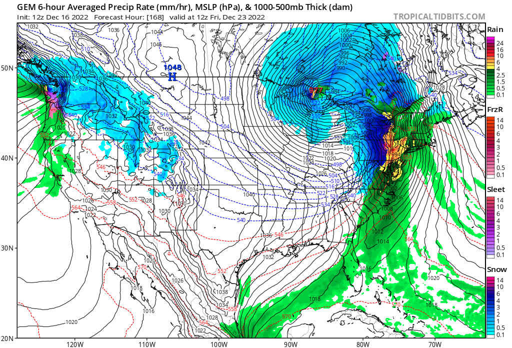
Wed rain arrives late morn to midday.  Steadiest and heaviest rain is probably late aftn to early evening.  But, as is my usual procedure, I don't want to get too cute w/timing on day 7.  So just a generic rain fcst.  Despite a very warm fcst, CAPE doesn't look impressive, so no t-storms mentioned.  I undercut temp guidance for two reasons.  First, you're never sure how warm it can get w/clouds and rain falling.  Secondly, I don't ever like to go to extremes on a day 7 fcst until we see which way it trends.  So for now, I have generally 50-55 for highs, but 55-60 along the I 91 corridor, but it is very possible this may have to be tweaked up in future fcsts.

​LR: It does appear that behind our Wed storm, the pattern begins to alter.  While it does not appear to be a bitterly cold pattern, near norm temps in Jan would be cold enough to produce wintry threats, and if it follows the pattern of the last step down, bitter cold could be waiting in the wings further down the road.

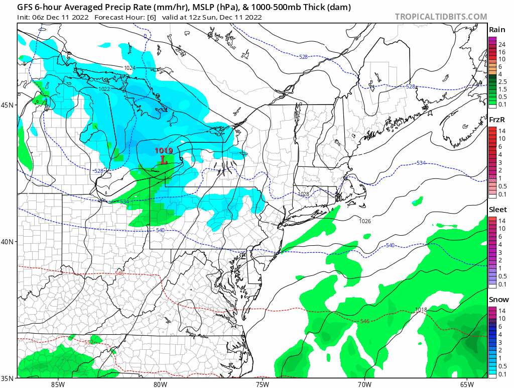
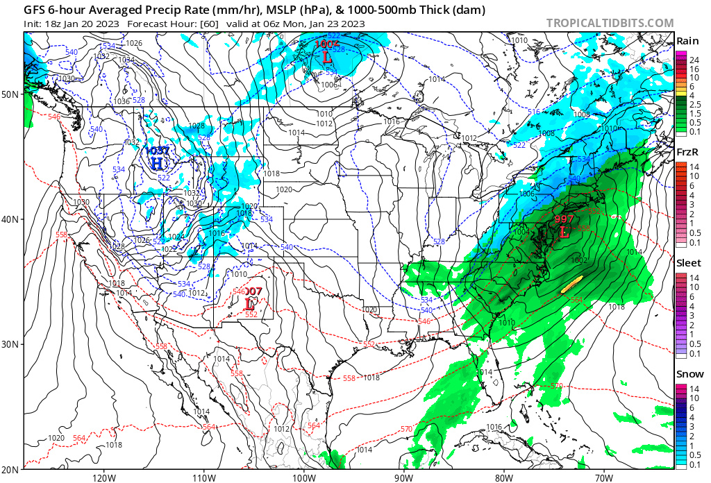
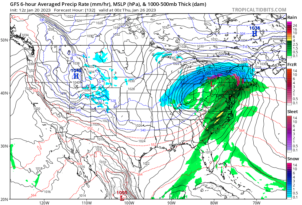
I have attached two images, both showing fairly generic rain events for this time of yr.  On the second map, valid Wed aftn, you can see chilly air behind the storm beginning to filter in.
Picture
Picture
That's all for today, take care and see you prob next Fri!

-GP!
Comments

Grinch Storm to bring multiple hazards to Connecticut in the days before the Christmas holiday...bitterly cold temperatures and wind chills for the holiday weekend...

12/20/2022

Comments

 
Good evening from Southern Connecticut Weather. 

Our focus in the discussion this evening is on our coming storm, which is now onshore and brought snow to Seattle and much of the Pacific Northwest today. The much discussed pattern has produced, but rather than snow in our region, it is sparking what one National Weather Service Office is calling a generational type winter storm for areas to our west. 
Picture
Above: the current map of advisories, watches, and warnings. From the East Coast to the Pacific Northwest, there are weather headlines up for this storm and the Arctic blast that will bring flash freezes and rare wind chills all the way to the Gulf Coast. This storm is the real deal, even if it doesn't bring us snow. 

Timing
The timing for this one has remained consistent. Most of Thursday looks overcast and dry during the daylight hours. As we get to later in the afternoon and early evening, showers should begin to move in from the southwest. I don't expect anything too heavy at the start, which should be between 2-6pm. Travel on the roads Thursday look fine. Airline travel will likely be a mess across the nation.

The precipitation will be relatively slow to move in, but it's the overnight hours and into Friday that we see the heaviest rain and strongest wind. It looks like Friday morning will have the heaviest rain, while the strongest winds may come later in the day as a powerful Arctic front approaches. 

Early Friday may have the worst travel conditions with heavy rain and wind, and some of the guidance is starting to show that Friday afternoon in advance of the front will have less heavy precipitation or even a break. 

However, the Arctic front will mean business, and is likely to pass between noon and 4pm. Temperatures in the 50s will drop rapidly, likely being below freezing between 3-7pm. This means that we need to watch out for icy spots across CT as the sun sets. 

The storm will depart Friday evening, and while some of the guidance tries to keep some moisture around as the Arctic front passes and bring a brief period of non-accumulating snow, I'm not buying it yet. 
Picture
Above: the latest NAM depiction of the Arctic front. We'll see temperatures in the 50s early on Friday crashing below freezing by the evening and potentially even down to the teens (more realistic) or signal digits (less likely) by Christmas Eve morning. Note the exceptionally cold temperatures to our west. 
Impacts
This is likely to be a high impact storm in the region, especially if you are considering travel during the Friday time period. There are multiple hazards with this one, and I will take them in order of impact. 

Strong to Damaging Winds--High Impact
This is the biggest hazard with the coming storm, but it's still unclear just how much we mix down the strongest winds aloft. I still believe that the majority see peak wind gusts on the order of 45-55mph, but there is potential for isolated gusts up to 65mph, especially in eastern and coastal CT. I still don't have the highest confidence in that occurring, and will want to get closer to the event before going with those highest numbers outside of isolated spots.

As it stands, however, we are looking at an event that will bring isolated to scattered power outages, that would be more scattered to potentially widespread if we see 65mph gusts. That makes this high impact, especially with the holidays approaching. Again, highest winds are on Friday. 

Flash Freeze--High Impact
For this impact, while I don't have high confidence yet that we see a true flash freeze, the potential is very concerning. As mentioned above, the Arctic front will quickly drop temperatures. While it's possible the break in the rain during the day allows for things to dry out, we could see black ice develop if roads remain wet as the front passes or if there's snow falling as the front passes.

The other issue is if you combine temperatures late Friday into the weekend dropping to the teens and single digits with bitterly cold wind chills and power outages, you have other issues right at home. 

If you are on the roads while the temperatures drop in the afternoon and evening, be especially careful as it only takes a little ice to cause major problems for motorists. 

Coastal Flooding--Moderate Impact
We have coastal flood watches for the entire shoreline for 1-3 feet of potential inundation late Thursday into early Friday. Fortunately, the impact here looks more limited, but for those right at the coast this could be impactful if we see higher end flooding. 

Heavy Rain/River & Stream Flooding--Moderate Impact
We're going to see heavy rain on the order of 1-3 inches, and while that by itself is unlikely to cause major issues make sure those sump pumps are ready as most of it will likely fall in a relatively short period. As a result of a widespread heavy rain event, there is the chance of river and stream flooding. One item from the NWS this morning caught my attention--models are showing a 30% chance of the CT River seeing a moderate flood. That is a low likelihood, but would be extraordinary given the current water levels. That's something I'll be watching. 
Picture
Above: the Canadian depiction of the storm. I'm using this instead of the GFS because the GFS nearly completely lost my trust in the long to medium range handling of this storm. 
Holiday Weekend Temperatures
One final thing to note is the post front temperatures for Christmas Eve and Christmas. This is going to be a cold (and dry) holiday weekend. Expect temperatures struggling in the 20s during daylight with breezy conditions leading to very cold wind chills. Although it'll likely be a non-snowy Christmas, at least it'll be cold?

It's hard to overstate just how uncommon this cold and snow (not here) is. We're looking at a fairly rare combination right around Christmas that will impact most of the continental US. Of course, rather than a winter wonderland the Grinch is visiting our neck of the woods, but this is really likely to be one of the biggest storms the US has seen in a long time. 
Picture
A​s always, please like, share, and interact with us on our social media--on Facebook to share our discussions, and follow us on Twitter @southernctwx to retweet our posts. Hit the buttons below to join.

Thank you for reading SCW. 

-DB
Follow @SouthernCTWX
Comments

...CHILLY WEEK GIVES WAY TO A COLD AND ACTIVE PATTERN...

12/16/2022

Comments

 
Disc: This is beginning to shape up to be a pattern where a medium and long range forecaster does not get much sleep, if you believe the chaos in the modeling to be any indication of low-confidence in actual forecasts, but more on that later.

Currently: Decaying primary over KMSP, sfc low over KNYC.  This storm is beginning to pull out of the area.  Light rain/drizzle may transition to snow, esp N & W, but any accums look very limited except maybe in the NW Hills.  Black ice could be a concern, but I think I'll limit that to sheltered valleys, since other locations should have enough wind to mitigate that concern.

Tonight: Basically already covered the first 1/2 of tonight in the "current" section.  I went a few deg under guidance for lows.  Skies will prob clear quicker than modeled, there is decent CAA and much of the state has some snowcover, so we'll radiate fairly efficiently, despite some winds. Lows mostly in the upper 20s.  Winds will gust to near 30 MPH at times, adding a chill to the air.

Tomorrow: Very quiet day.  Temps generally near normal, NBM guidance followed closely.  Still some wind gusts to 30 MPH early in the day, diminishing as the day goes on.  Generally mostly sunny, but could go p/cldy in the afternoon from diurnal cumulus.  Temps generally in the low 40s for highs, maybe a few mid 40s in the I 91 corridor.

Tomorrow Night/Sun: A cold front will go thru on Sun w/o much fanfare.  There could be a passing flurry w/this feature in the NW hills.  Temps could be a bit tricky and could max out around noon, before the fropa.  The most notable wx behind the front will be wind, w/some gusts to near 40 MPH.  Generally followed temp guidance closely, but I went below guidance in the NW Hills, w/early fropa.  Highs generally near 40, maybe only mid 30s in the NW Hills.

Long Term: The wx begins to get more interesting and more low-confidence as we head into the long term.

Mon: Fair, but cool and windy.  Again followed temp guidance pretty closely, and applied the same logic as w/Sun.  High temps generally low 40s, except some upper 30s in the NW hills.  Winds gust 35-40 MPH thruout the day.

Tue: W/no more CAA at all, generally followed guidance closely again, but this time went warmer along I 91.  Highs generally near 40, but 40-45 along I 91.  Winds gradually diminish thru the day.  A few gusts to 35 MPH possible in the AM.

Wed: Developing NE flow pulls cooler air down from high press to the N.  This means a cooler day.  Went just a tad under guidance, w/highs in the mid to upper 30s.

Thu: I am going way under temp guidance.  There is a strong CAA signal and the NBM guidance is contaminated with outliers that have a faster storm.  So highs of 30-35 seems reasonable.  For now, will just call it increasing clouds, but keep the day dry.

Fri: Here is where the wx really gets complicated.  It's the American model (GFS) vs the foreigners.  The foreign models have a westward track, which would mean rain, or snow changing to rain.  The GFS model has a major snow storm.  Either way, it is a very large storm and would feature very strong winds both during and on the back side of the low.  For now, the only thing that is certain is that a storm is coming and there will be significant amounts of pcpn and wind.  Subtle differences in the atmospheric setup, especially at 500 MB, will result in major differences in storm track and sensible wx here.  For now, I have the fcst about 60% in the GFS camp, only to preserve continuity w/trends.  However, as I said, this fcst is of very low confidence! Because of the low conf fcst, I did not make any significant adjustments to temp guidance, maybe just a deg or so lower in spots.  Highs generally fcst 30-35 for now.

LR: The LR pattern may hinge largely on what happens w/the Fri storm.  Much of the guidance that has an inland track flips us to a warmer pattern after New Years.  However, the guidance that has big snows Fri has a frigid and snowy pattern.  Either way, there could be 1-2 more snow threats before any potential breaks in the pattern.

I posted two graphics today, both for the Fri storm.  One is the GFS and the other is the Canadian model, just to give an idea of the differences in modeling.


Picture
Picture
Anyway, that's all for now, see you next time!

​-GP!
Comments

Heavy wet snow possible for the NW hills on Friday

12/14/2022

Comments

 
Good evening from SCW,

We’ve got an impactful storm on the way, with heavy rain, noticeable winds, and high-elevation snow expected for the region starting late tomorrow evening and going into early Saturday. While everyone will see precipitation, we’re expecting accumulating snow to be confined to the interior, and any noticeable impacts from snow to be confined to the northwest hills, where a substantial amount of heavy, wet snow is likely. 

Let’s take a look at the setup. Below is a loop of simulated radar from the GFS from Thursday morning through Saturday afternoon, courtesy tropical tidbits.
Picture
This model run depicts a pretty classic coastal storm track for us, with low pressure coming up from our southwest before transferring to a coastal low south of our region. With a colder airmass in place or stronger blocking to our north, this would probably be a substantial snowstorm for the region. However, the system is moving into a marginal airmass, and that, combined with the relatively weak blocking, is allowing enough warm air to be sucked into the system such that the lower elevations are primarily cold rain. As the storm begins to push to the east, we’ll see temps drop enough for most areas to switch over to snow, but there probably won’t be enough moisture left for more than a light accumulation, if any at all.

The story is very different in the NW hills, however, where elevation will allow for colder air to be trapped for longer, which, combined with heavier precipitation rates, should create just enough dynamic cooling for the predominant precipitation type to be heavy wet snow. The range of model solutions ranges from keeping the hills all snow for the duration to mixing with and changing to rain during the peak of the storm when the warm nose is furthest north - we’ll look to hone in on the more exact timing tomorrow once we get some model consensus.

To show that, let’s take a look at soundings (essentially, profiles of the atmosphere) for 1 PM on Friday at ~1500 feet in the NW hills. 
On the GFS (left), colder air is still holding on in the column, with temps only warming right at the immediate surface. Verbatim, I’d still expect this to be a snow sounding in periods of heavier precipitation, as dynamic cooling would keep the column at 32f down to the surface. On the Euro (right), however, it’s a different story, as temps are at/above freezing all the way down from 850 mb (several thousand feet above the surface) and, outside of perhaps the heaviest precipitation, this would just be cold rain. Which temperature profile ends up being the most accurate will ultimately determine snow totals in the hills; as we see models come to a consensus tomorrow, we’ll likely have to adjust our snow forecast one way or another.

As far as total precipitation goes, all models are looking healthy with QPF, with a general 1-2” of liquid expected across the state. We’re certainly not worried about precipitation making it into our area with this storm; it’s the temps that are going to rule the day here for snow accumulations or the lack thereof.

Forecast
Picture
As we discussed above, we’re expecting substantial impacts from snow to be limited to the NW hills. That said, with an elevation based event like this one, it’s almost impossible to show all of the details on a map, so consider it as somewhat of a guide. Generally though, in the highest elevations (above ~1500”), we expect the event to be substantially if not all snow, with close to if not warning level totals likely. The next band down (~1000-1500’), is the toss-up zone, where the cooler model solutions would bring a substantial amount of snow to the area while warmer solutions would be a quick inch or two and then over to rain. We mostly blended the models for this zone and then hedged just a hair colder, but this is definitely the area that I’m less confident in, and I wouldn’t be surprised to see tweaks in either direction tomorrow here. Below ~1000’, we’re relying on back-end snow to bring any accumulations we see. If the cold air comes in faster than expected or heavier bands of precipitation linger as the storm moves away, we could see a couple of inches, but I expect most outside of the NW hills to be closer to a coating than anything more.

This map is essentially a blend of model solutions that slightly favors the colder solutions, mostly due to the heavy precipitation rates and models often underestimating the amount of cold air available to our north. I think it would take a fairly large shift in guidance to bring totals up substantially, but we’ve certainly seen those shifts before… so never say never. On the other hand, however, a slight shift warmer on models would lead to this primarily being a rain event for all outside of the highest hills in NW CT (2000’+), which, while I don’t think is likely, is still an outcome that’s within the range of plausibility. We’ll hopefully get some more confidence tomorrow and will keep you updated.

Timing & Impacts

If you are hoping for widespread school cancellations, this is not the storm for you. Expect precipitation to move in Thursday night for most of the state. Areas away from the coastline may see a short period of snow at the very beginning of the storm, but that will quickly transition to a wintry mix and then to rain as warmer air works in. Precipitation continues overnight Thursday into Friday morning; if the northwest hills do change over to rain, I’d expect it to happen after sunrise on Friday. Precipitation begins to move out and become more scattered late on Friday, but things likely won’t fully clear out until very early Saturday morning. As colder temps come in on Friday evening, any areas in the hills that turned to rain will turn back to snow, and we may see some brief snow across lower northern areas to wrap things up, though any accumulations will remain minimal. The morning commute is likely to be tricky regardless of whether you are seeing rain or snow, and while widespread cancellations are not expected in Connecticut, they are likely in the NW hill towns, possible in NE hill towns, and far less likely elsewhere. There may be more scattered to widespread delays depending on how quickly things change over to rain.

For most, the main impact will be a wet, windy, raw Friday; it will definitely not be a great day to be outside. In the NW hills, where heavy snow is expected, difficult driving conditions are likely, and the risk of power outages from heavy wet snow is elevated. I don’t think the wind alone will be strong enough to cause major issues, but the snow and wind combined can be a strong one-two punch that will (especially if the snowier side of the forecast verifies) cause power outages, downed trees, etc. Nothing out of the ordinary for this region during the winter, and definitely nothing we haven’t seen before, but taking the usual preparation and precautions (making sure you have some food and water, gas for your generator if you have one, warm clothes, fully charged phones, etc.) will always serve you well.

All in all, expect a cold and wet Friday for most of the state, with a tricky forecast for the NW hills leading to high uncertainty around the risk for heavy wet snow. Luckily, we clear out for the weekend, with mostly sunny skies (especially by Sunday) and crisp temps expected; perfect for holiday shopping, decorating, and, for those of you in the NW hills, shoveling!

We’ll be back tomorrow with a final call. Until then, ask any and all of your questions on our social media pages, share our discussion with your friends and family, and thank you for reading and trusting SCW.

-SA
Comments

Snowfall forecast increasing as first meaningful winter weather event of the season comes into better view...

12/11/2022

Comments

 
Good morning from Southern Connecticut Weather. 

This one has risk written all over it. As a forecaster, having confidence in your prediction is often based on the stability of trends in the modeled environment and guidance itself. In this instance, we've seen a significant trend toward more impactful in the last 36 hours. We started with a minor to moderate event, and with the forecast you will see below, we now see something solidly moderate for many with even higher upside if things come together. Let's jump right in. 
Picture
Above: the final call for CT with this system. This is a compromise between the very aggressive high resolution guidance, which has been showing a wide swath of warning level (6"+) snows and the more tempered global guidance (Euro/GFS) which show less. 
Snow Accumulation
We've upped the numbers because soundings continue to look very dynamic, increasing the potential and confidence in a period of moderate to heavy snow tonight. It's unclear just how much we will realize this potential and there will likely be winners and losers depending on the banding, which has jumped all over the place and basically touched every part of the state at least once through these model cycles. 

For virtually all of interior CT (with the exception of far SE zones), we're going with a general 3-6". Expectations for folks in this zone should to hedge toward to lower to middle end of this zone, with a final accumulation of 3-5", but be prepared for an overperformer.

Some high resolution guidance is trying to paint a stripe of 8-10" for parts of the state. It's hard to completely buy with the Euro and GFS not going bigger (though the GFS did briefly last night) but I won't discount that a narrow zone most likely in northern CT surges past our upper range. As a result, we are including wording for locally higher amounts in our map. 

For coastal CT and part of inland SE CT, the expectation is that some of the precipitation will be rain or a mix before changing to all snow. Even here however, do not let your guard down. We have less confidence in a solidly moderate event here, but that doesn't mean the potential isn't there. SW CT folks in particular need to watch for an overperformer. If there was an area that I'd be most worried about only seeing a coating or inch, it'd be right along the shoreline in SE CT. 
Picture
Picture
Picture
Above: A selection of high resolution guidance showing precipitation (top) and the HREF (bottom) showing a snowfall mean. The latest version of the HREF has not run yet as of this post. While there's upside looking at models like the HRRR, a blend is best here. Top images courtesy of weathermodels.com.
Timing
A quick look at the radar this morning shows that flurries may already be starting in spots, right on time with our post last night. Travel conditions look fine through the daylight hours, but snow will steadily get heavier this afternoon and especially after dark, so be careful on the roads. The heaviest is likely through the overnight period with it tapering off during the early morning hours. Snow should be done between 5-7am, but we will watch to see if an inverted trough sets up to prolong the snow tomorrow morning. 
Picture
Above: Current radar image. It'll take time to saturate the column and bring in accumulating snow. 

Impacts
For inland areas, 3-6 (and potentially higher) gets you into moderate event territory because it makes this a plowable event. Moderate to heavy snow will be possible this evening and into the overnight hours, before tapering off by daybreak. That's also important, because it means the timing of the heaviest will occur when roads are least traveled. This would be a higher impact event if it happened tomorrow. 

That said, with a plowable event it increases the likelihood of school delays. Those may be widespread tomorrow. I think cancellations are unlikely except in the hardest hit areas, but we have to see how things play out. I don't expect any strong winds or significant power outages from this system. 

To illustrate the overall evolution of the system, here are loops of the GFS (top) which is one of the less bullish models, and the 12km NAM (bottom) which is one of the most bullish models. 
Picture
Picture
Overall
This is one that's likely to produce a widespread plowable event of moderate impact. Most will end up with 1-3" at the shore and 3-5" inland, but there is significant upside potential in a narrow zone most likely in northern CT. This one is a quick hitter, and then we turn our attention to next week...

A​s always, please like, share, and interact with us on our social media--on 
Facebook to share our discussions, and follow us on Twitter @southernctwx to retweet our posts. Hit the buttons below to join.

Thank you for reading SCW. 

-DB​​
Follow @SouthernCTWX
Comments
<<Previous

    Archives

    April 2023
    March 2023
    February 2023
    January 2023
    December 2022
    November 2022
    October 2022
    September 2022
    August 2022
    July 2022
    June 2022
    May 2022
    April 2022
    March 2022
    February 2022
    January 2022
    December 2021
    November 2021
    October 2021
    September 2021
    August 2021
    July 2021
    June 2021
    May 2021
    April 2021
    March 2021
    February 2021
    January 2021
    December 2020
    November 2020
    October 2020
    September 2020
    August 2020
    July 2020
    June 2020
    May 2020
    April 2020
    March 2020
    February 2020
    January 2020
    December 2019
    November 2019
    October 2019
    September 2019
    August 2019
    July 2019
    June 2019
    May 2019
    April 2019
    March 2019
    February 2019
    January 2019
    December 2018
    November 2018
    October 2018
    September 2018
    August 2018
    July 2018
    June 2018
    May 2018
    April 2018
    March 2018
    February 2018
    January 2018
    December 2017
    November 2017
    October 2017
    September 2017
    August 2017
    July 2017
    June 2017
    May 2017
    April 2017
    March 2017
    February 2017
    January 2017
    December 2016
    November 2016
    October 2016
    September 2016
    August 2016
    July 2016
    June 2016
    May 2016
    April 2016
    March 2016
    February 2016
    January 2016
    December 2015
    November 2015
    October 2015
    September 2015
    August 2015
    June 2015
    May 2015
    April 2015
    March 2015
    February 2015
    January 2015
    December 2014
    November 2014
    October 2014

    Categories

    All
    Tropical Weather
    Winter Forecast

    Authors

    Southern Connecticut Weather is brought to you by Timothy Wrightington Jr. (TW), Spencer Aronstein(SA), Greg Petridis (GP), and Don Bell (DB).

Picture
Copyright Southern Connecticut Weather 2018, all rights reserved. 
For website related inquiries, email us at support@southernconnecticutweather.com

Privacy Policy/Terms of Service