|
Good evening from SCW!
We’ve got a major winter storm on our hands for tomorrow evening into Thursday that will bring significant snow accumulations to the entire state. In this discussion, we’ll dive into our final snow map, look at what’s changed since yesterday, show the uncertainties that remain in the forecast, and discuss timing and impacts. We’re also going to be live on our Facebook page tonight from 7-8 PM to take questions on this upcoming system, so feel free to stop by and say hello! With that, let’s jump right in. Forecast Snowmap 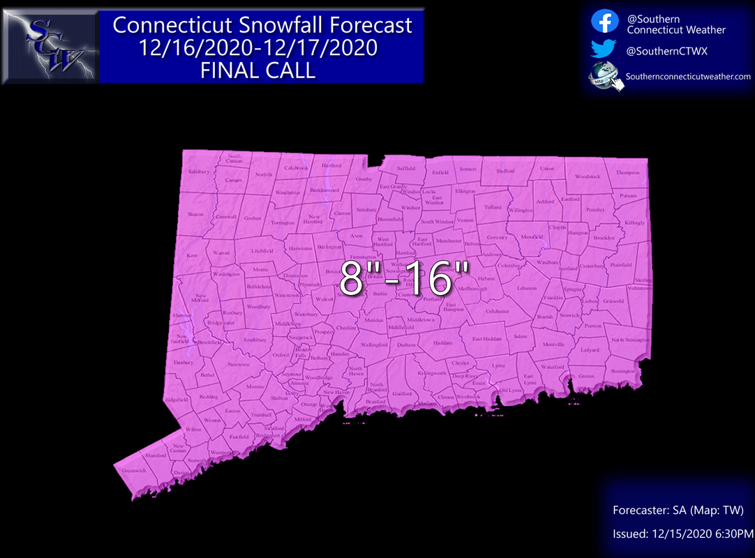
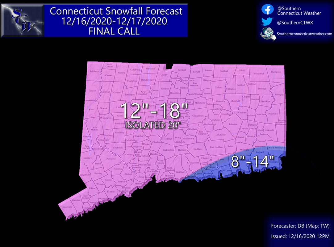
Our final call for the event is the same as our first call yesterday; 8-16 inches of snow statewide. We tried to tighten up the ranges this afternoon and introduce multiple zones to the forecast but decided as a team that there is too much uncertainty remaining in the models regarding where the best banding develops (more on that in a minute) to get more specific, and we’d rather have a large range and be right than try to get too fancy and end up missing the mark. Details are good, but only if they are accurate and reliable. That said, we will continue to watch the guidance, and should there be an opportunity to get more specific tomorrow, we will publish a revised map.
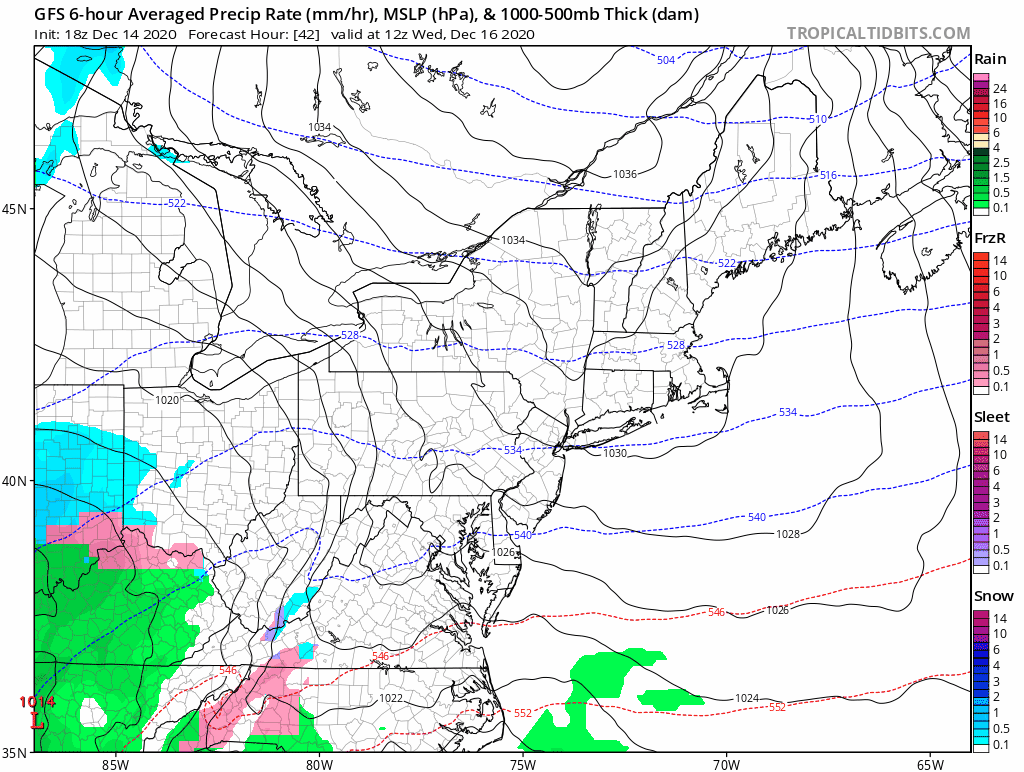
Models, Trends, and Changes When Don wrote yesterday, he showed the Euro and Canadian models, which were big hits for the state, and also showed the GFS model, where totals were lower because banding stayed to the south of Connecticut. He suggested that the model was on an island and away from its own ensembles, and expected it to move north to match the consensus. By and large, that’s what happened, but we also saw a noticeable shift north in the consensus track as well through the midday runs, so much so that we were starting to get concerned about potential mixing in southern areas and the heaviest banding confined to the NW hills. However, on the most recent 18z runs, we’ve seen a shift back south on the models, suggesting that we may have reached the extent of the north trend. The current position of the system is ideal for strong banding to develop over Connecticut, resulting in big snow totals for those lucky (or unlucky depending on your point of view) to end up under it. Here’s a look at the five most recent runs of the NAM from 18z yesterday to 18z today. Notice how the heaviest banding (darker blues) shifted from central CT on yesterdays run up into MA and southern NH before coming back down into CT on the most recent run, and notice that along the shoreline, warmer air and lower precip rates are enough to turn things over to mixed precipitation for a time. 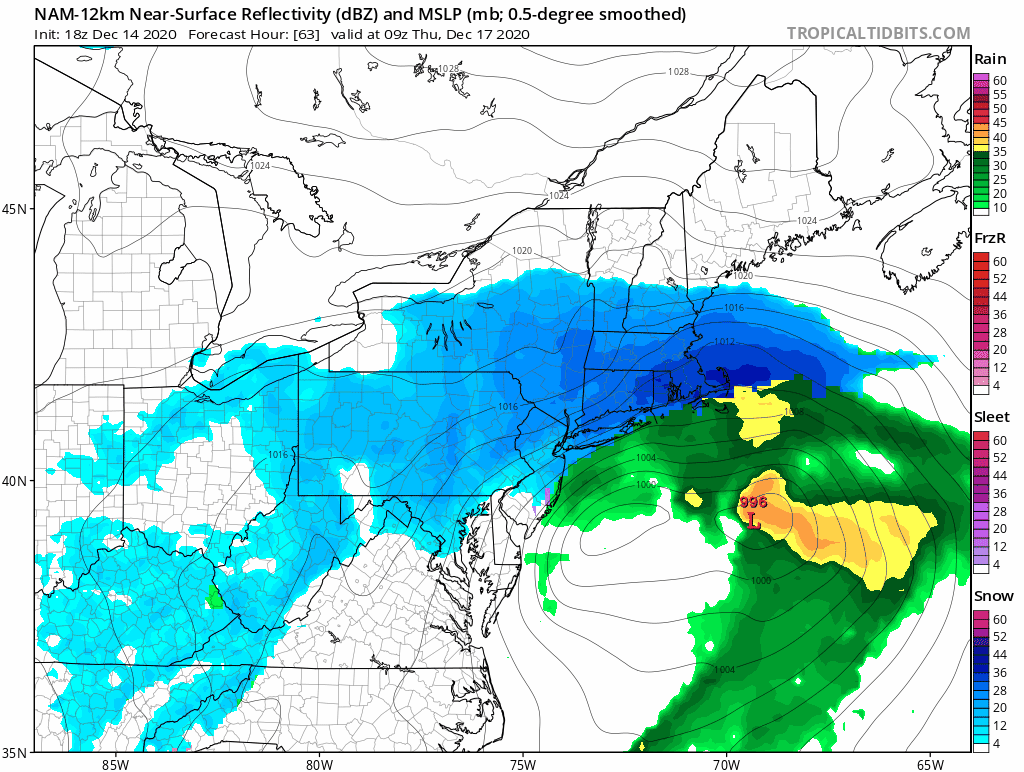
Overall, the trend has clearly been towards enhancing the banding aspect of the system – this snapshot from the RGEM shows it sell, with a heavier band of snow into southern VT/NH, a dryslot in northern CT/MA, and then another band in southern and eastern CT. Note that this is one of the more northern solutions; plenty of other models pull that larger band down into northern CT, but I like this view to show the structure of the system as the two bands are clearly outlined.
This type of structure is not uncommon in large storms, but it means that there are areas of high totals right next to areas of much lower totals, as the banding tends to create subsidence on either side of it and hence a dry slot with lower precipitation rates or even none at all. What’s less clear is where the banding ends up. If we see the storm stay in the same position that it’s in now, we’ll likely see a heavier band along the shoreline and then another one in the NW hills, with the center of the state in a relative minimum (but still a significant snowfall). However, any small shift north or south will cause a shift in that distribution, hence why we kept a broader range across the state. I’m hoping that we can zoom into two zones (likely 8-12” and 10-16”) tomorrow as we get more clarity on the final track and hence band placement, but we’ll see if we can get any better consensus. To sum it up – we’re still on track for a large system, but the trend is towards a more banded precipitation shield, meaning that there will be high amounts of variance in totals across relatively small distances and it’s difficult to know where the relative mins and maxes will be. Remaining Uncertainty We covered a lot of this in the above section, but let’s briefly sum up what we know and don’t know. What we know:
What we don’t know:
Timing and Impacts Timing Here’s a loop of the entire system (1 PM Wednesday to 1 PM Thursday) from the RGEM. Take this as a general idea of how the timing progresses and not as an indicator of where the heaviest snow will fall, as there’s still quite a bit of uncertainty with the banding. 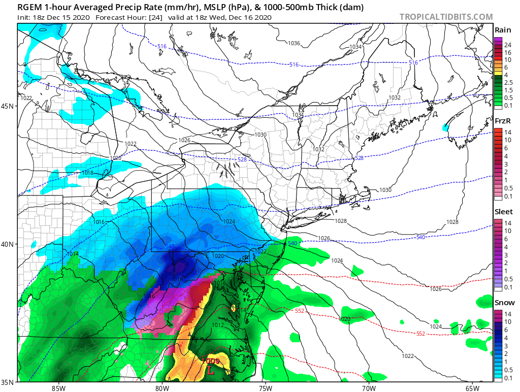
Generally, we’ll see snow break out during the late afternoon into early evening in southern and western areas, and by 8-9 PM we should be snowing across the entire state. Interestingly, there is a fair amount of spread in the models with regards to timing; the RGEM has snow across the entire state by rush hour tomorrow, while the hi-res NAM and GFS hold any snow off until after 6-7 PM and don’t get the entire state going until late into the evening. I’m hedging a bit towards the faster models as storms generally both come in and leave a little earlier than modeled, but we’ll clarify tomorrow in our updates. At first, I expect heavy snow across the entire state through the evening hours. By around midnight, we should see the storm start to form distinct snowbands, and areas under the band will continue to see very heavy rates while areas between bands will likely slow down a bit. We’ll see bands continue to move across the state through the overnight, and then most models show a final push of heavier snow across the entire state as the backside of the storm swings through and it exits to the east. That push of heavier snow will likely fall during the morning commute on Thursday, so if you are traveling to work, leave plenty of extra time and take it easy out there! Wind The highest gusts will be along the shoreline, where wind gusts could approach 40-45 mph for a time overnight during the height of the storm. We could verify a blizzard at some stations, but I don’t think we’ll meet the criteria (heavy snow and 35mph+ gusts for 3+ hours) at most (if any) stations away from the shoreline. Some models do suggest a brief period of stronger winds inland Thursday morning as the low moves to the north, but I don’t think it will be long enough to verify a blizzard anywhere but the shoreline (and the snow rates will likely have slowed down a bit by then). Still, wind gusts of 25-35 MPH are likely inland, enough to cause noticeable blowing snow and limited visibility. Here's a look at the peak winds on the GFS - notice the area of stronger gusts expands inwards on this panel. For the rest of the system, they are confined to the shoreline, so I don't expect blizzard conditions to be met anywhere but the shore. 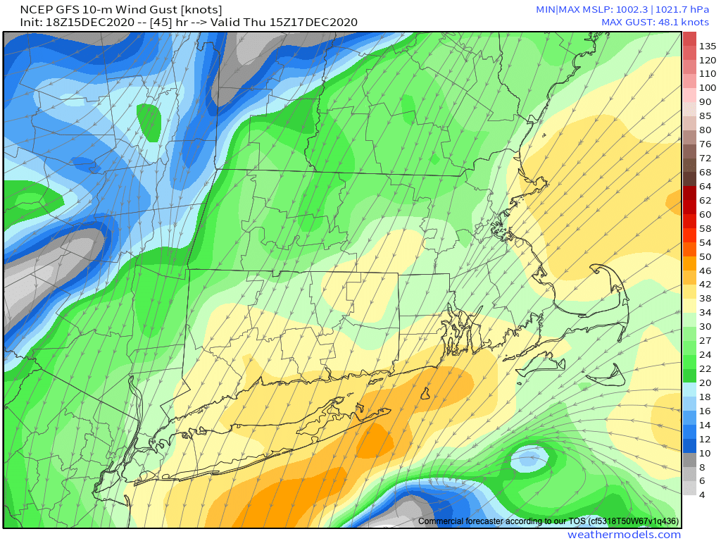
Power Outages
Whenever heavy snow is involved, power outages are a possibility. Don wrote yesterday that we expect the snow to be lighter; while that could still be true, if we see a more northerly solution, that suggests a heavier, denser snow in our southern zones. I think the shoreline is most likely to see outages due to the winds and potential for lower snow ratios, but I don’t think they will be widespread. That said, if you frequently lose power in your neighborhood, I’d be ready. Closings and Delays Most schools are currently virtual, however, for those with in-person operations, I would expect most if not all to close their buildings on Thursday. By the afternoon, conditions will improve significantly, so some businesses may opt for a half-day schedule, but I don’t think it will clear up in time for schools to sneak by with a delayed opening. Overall Impact While the timing is ideal for travelers and the lack of high wind will keep us from a major power outage scenario, we still think that this is a high-impact event. Widespread double digit snow totals have been rare in Connecticut in recent years, and when we see them, they tend to leave a mark. Expect difficult and hazardous travel Wednesday night into Thursday morning and an enhanced risk of power and wind issues along the shoreline and in traditionally favored areas. If possible, we’ll have a revised map out tomorrow morning, and regardless will be providing you with frequent updates throughout the day and into the night. As always, we look forward to your questions, comments, and interactions here and on our social media platforms – use the buttons below to follow us and don’t hesitate to send us your questions on Facebook and Twitter. Plus, don’t forget our live discussion and Q&A from 7-8 PM on Facebook Live! Hope to see you all soon, and as always, thank you for trusting SCW. -SA
Good evening from Southern Connecticut Weather.
Here we go. While we have seen some relatively large snowfalls in parts of Connecticut the last few years, it has been hard to get a major winter storm statewide. We've been tracking the upper level pattern for a few weeks now, and we have been tracking this discrete threat for approximately a week. Winter Storm Watches have been issued for all of Connecticut, and confidence is increasing that an area of low pressure will bring a high impact statewide event. For those that follow weather closely, this has the potential to be the first megalopolis (DC to Boston) KU event since March 2018. This forecast will look at the overall progression of the storm and the five elements we will be graded on after our final forecast: snowfall accumulation, timing, wind, power outages, and overall impact. Let's dive in. 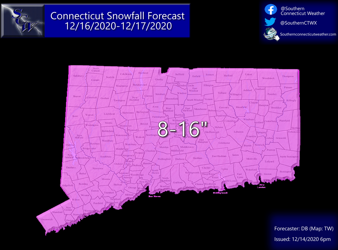
Here's our first call map. I already know what some of you are saying: "All this hype for an 8" snowstorm? X model says we're getting this much!"
We believe it is prudent to blend guidance rather than latch onto one model. We look at the whole field, and here we are blending the European (and ensembles) along with the GFS (and ensembles), with the other global and some select high resolution models to a much lesser degree. We weigh the bullish European model more in this instance. As you will see, that model has had CT locked in its sights for days now. As a result, our first call has a reasonable upper end of 16". The GFS on the other hand, has been further south and weaker with the storm. We think it's off, but not necessarily to the extent where we don't even factor it into the forecast. Most important, it has a sharp cutoff to the north along the northern border of CT that would easily cause higher forecasts to bust if it were right. We think 8" is a reasonable floor for CT, which is a major snowfall in itself. But we know that snowfall accumulation isn't the only thing that makes a winter storm high impact.
Overall Progression
Winter Storm Watches are up from Virginia to Massachusetts at this hour. That doesn't happen without a favorable upper level pattern. As I discussed earlier in the week, we have high latitude blocking in the form of a -NAO that is in place. Recall that those are usually a prerequisite for a major winter storm in Southern New England. In addition, our now departed Wave 1 is forecast to become a powerful low pressure and fill the 50/50 region, providing additional support for the coming low. Although this isn't quite a textbook setup, look at blocking as a traffic jam. When blocking is in place, traffic backs up. That allows for storms to develop in the right location and slowly move through the region rather than zip through. This isn't the longest duration snowstorm, or the strongest, but it is likely to develop at the right time that allows for a dynamic situation to unfold. 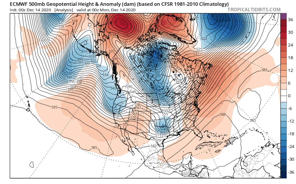
Above: European model depiction of the 500mb progression from Wave 1 to Wave 2.
So what's the result? Let's talk snow.
Snowfall Accumulation
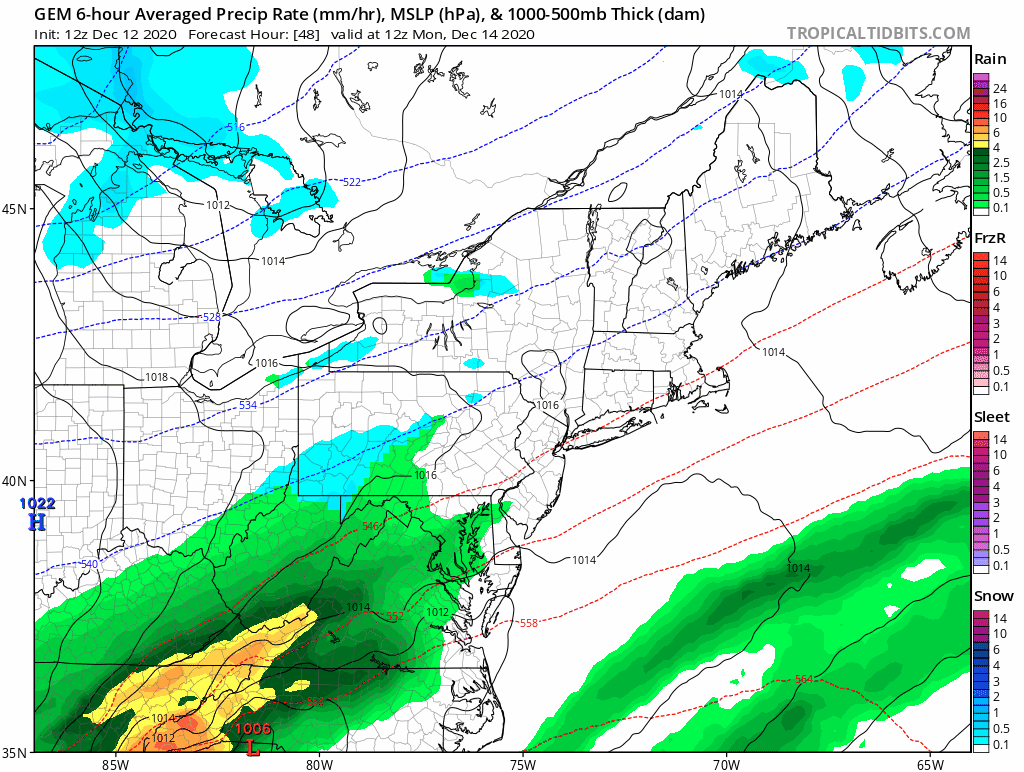
We anticipate a major snowfall of at least 8-16" across Connecticut. Aside from what I mentioned earlier, there are a couple of things that make this storm different from some of our other recent events. First, we expect this to be all snow, even at the coast. Today's minor event, in addition to slowing down traffic in the high latitudes, is also going to bring in a fresh shot of cold air tomorrow that will be reinforced by an Arctic high pressure as the storm begins late Wednesday. That means even down to the coast, we should see snow. Second, the snow looks to be at the general or slightly higher ratio standard. That could enhance snowfall and ensure that we all see a warning level (6"+) event. Third, the banding with the system looks robust across guidance. Even the GFS, which has kept the banding south, shows a very prominent band setting up in association with the storm. Most guidance (minus GFS) has that banding signature right over Connecticut. This is a compelling signal for at least 8" and likely much more across most of the state. The biggest risk for folks seeing the "floor" of 8" is far northern CT. Banding always creates a boom or bust scenario for us, so beware. Although we're not weighing it as much as the Euro, the Canadian model below has a good illustration of how we think the storm will progress. If this holds true we're looking at widespread double digit snowfall across the state. 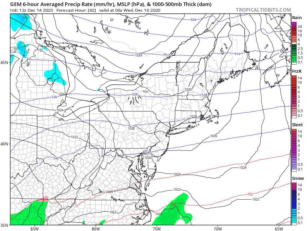
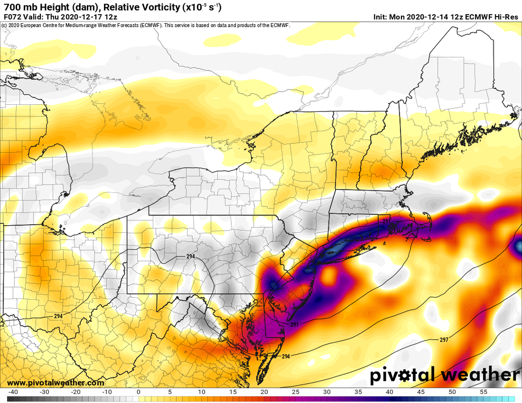
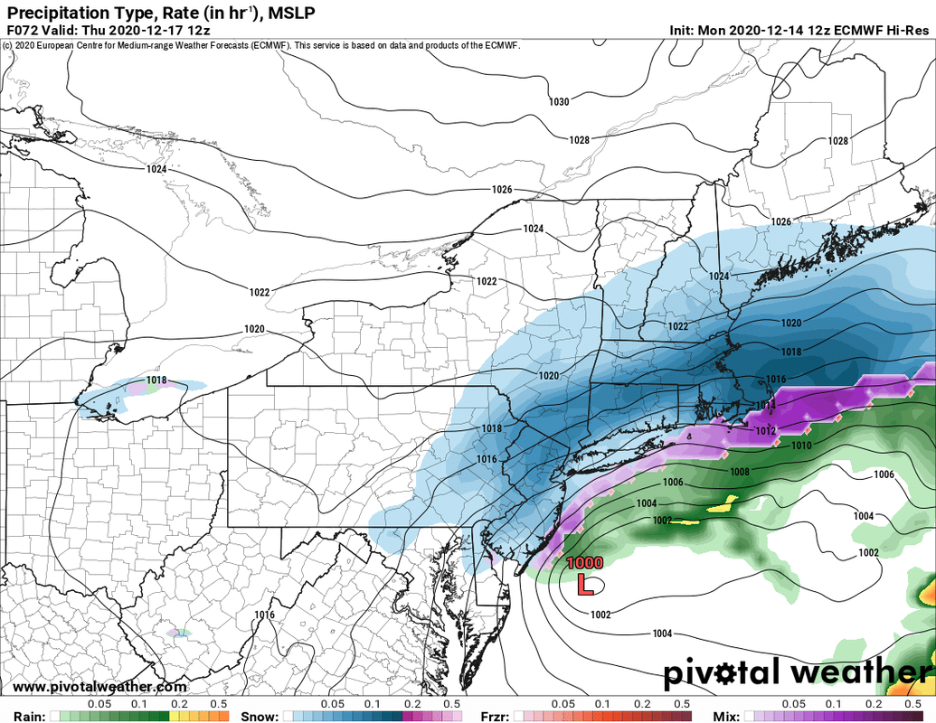
Below, a look at the 700mb relative vorticity of the storm (left) and result (right) on the European model courtesy of Pivotalweather.com. You see where the best forcing is taking place on the left, and the result is heavy snow just along and north of that area on the right. That's a big signal for big snow. The European model and its ensembles has held this signal for days.
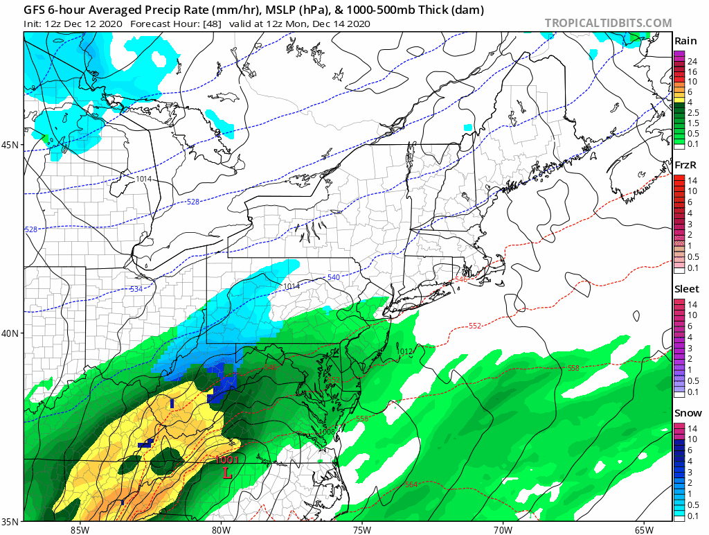
To provide a complete view, however, we must look at the GFS. Now, it is out on an island, and its most recent ensemble trended northward in a meaningful way, but this operational look shows how just a shift south or less dynamic system could move much of Connecticut closer to the floor. Note how the banding is just south of CT. We think this has a low risk of happening, but because it's on the table, our floor is lower.
Timing
Timing the storm seems fairly steady forecast wise here. The first flakes should begin flying late Wednesday afternoon and evening from SW to NE. The heaviest of the snow happens during the overnight hours and Thursday morning, before winding down from west to east late morning into the afternoon. As it stands, the Wednesday evening commute could be impacted but looks ok right now, while the Thursday morning commute looks very messy and potentially hazardous given high snowfall rates. This timing can shift and needs to be honed in a bit more, so stay tuned. Wind This has blizzard potential at the shoreline. Remember that blizzards are defined as having 1/4 mile or less visibility and frequent gusts of at least 35mph for three consecutive hours. Because the shoreline is the best wind spot usually, that's the place that has the highest likelihood of verifying blizzard conditions. Inland is tougher, and although there is a fairly strong gradient that will produce windy conditions, it is unclear whether the low will be strong enough or close enough to bring that kind of wind. Highest gusts along the shoreline should be between 40-50 mph with less wind inland. This isn't a high end wind producing winter storm. Power Outages With wind and heavy snowfall likely, there will be power outages. However, we are expecting a more fluffy snow, which has a lesser impact on the electrical grid, and do not expect high end wind that could cause widespread damage. We think that the potential is there for isolated to scattered power outages statewide, with the highest risk near the shoreline. As usual, those that lose power in any wind event should be prepared in this instance as well. Overall Impact We think this is a high impact event statewide. While we are not expecting widespread power outages and a good portion of the snow is expected to fall overnight Wednesday, we think it will be a high snowfall with high snowfall rates possible Thursday morning with blowing and drifting snow even if there isn't blizzard criteria met. Should we see banding produce over CT it could be one of our higher end widespread snowfalls, relative to the last few years. Although it seems like we've been tracking this for a long time and the storm is almost here, we're still about 48 hours from onset. There's a lot that can happen between now and then with banding signals and the intensity of the low that could change this first call forecast in one direction or another. As it stands, we're forecasting a major statewide snowstorm, and we are forecasting this with higher than normal confidence. Stay tuned. As always, please like, share, and interact with us on our social media--on Facebook to share our discussions, and follow us on Twitter @southernctwx to retweet our posts. Hit the buttons below to join. Thank you for reading. -DB
Good evening from Southern Connecticut Weather.
When I wrote yesterday, I stated that there was high uncertainty regarding Wave 1, which is set to impact our state tomorrow. Since then, we have seen the guidance slowly converge on a solution, and we now have higher confidence in a minor event. While we are more confident in a period of snow tomorrow, there's still a touch of uncertainty about the potential here. That said, here's our forecast. 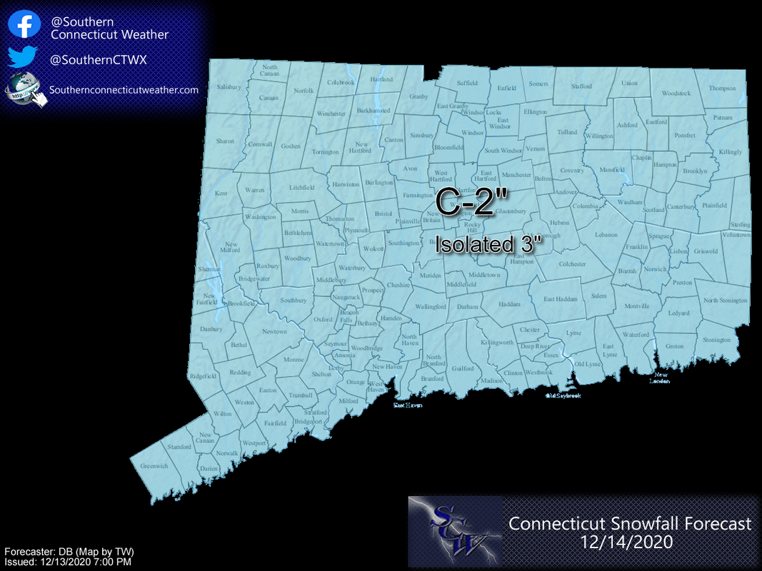
Timing
This looks pretty straightforward. An area of low pressure (Wave 1) will develop to our south and slide off the coast tomorrow. The track now looks north enough to bring us a period of precipitation. Early morning looks fine, but as we get into the mid-morning and early afternoon hours we will see rain break out from south to north. Over time, we will see the column of air above us cool, even if the surface remains above freezing, and we should all flip to a period of snow. It may take longer to flip near the shoreline. This should be a quick mover, with most of the precipitation falling through the afternoon and early evening hours. We will clear out overnight, and in the wake of the storm we will see a cold but quiet Tuesday. 
High resolution NAM depiction of tomorrow.
Snow Accumulation
As you saw in our first image, we are going with a general range statewide of a coating to two inches. We're doing this because we could see a wide variation across the state, similar to our early December storm, where places that have heavier rates will see snow and accumulate, while other places struggle to accumulate at all. What we do expect is that most snow will accumulate on non-paved surfaces. Some places will see very little snowfall, while others may see an inch or two. A few spots could see three inches but that would require a "boom" scenario. 
Overall Impact
We expect this to be a low impact event. Surface temperatures look to be above freezing virtually everywhere, which will reduce the impact on the roads. We do not expect significant wind or enough snow to cause power issues. The fast moving nature of the storm also helps. The PM commute does look messy regardless, so take it easy on the roads! Black ice might be an issue after the storm as cold air rushes in overnight. That will set the stage for Wave 2, which is expected to impact the region on Wednesday/Thursday. All indications are that Wave 2 has the potential to be a blockbuster for Connecticut. Stay tuned. As always, please like, share, and interact with us on our social media--on Facebook to share our discussions, and follow us on Twitter @southernctwx to retweet our posts. Hit the buttons below to join. Thank you for reading. -DB
Good afternoon from Southern Connecticut Weather.
With the overall upper level pattern settling into a conducive state for winter storm chances and guidance in unanimous agreement about two distinct events, we are declaring the week ahead a SCW Period of Interest. This post is intended to provide a brief overview of what we're seeing and provide early thoughts. Expect a lot more posts here, on Facebook, and on Twitter @southernctwx in the coming days as the forecast comes into better focus. If you haven't joined any of our pages yet, this would be a good time. Now, with that shameless plug out of the way, let's dive in. :) 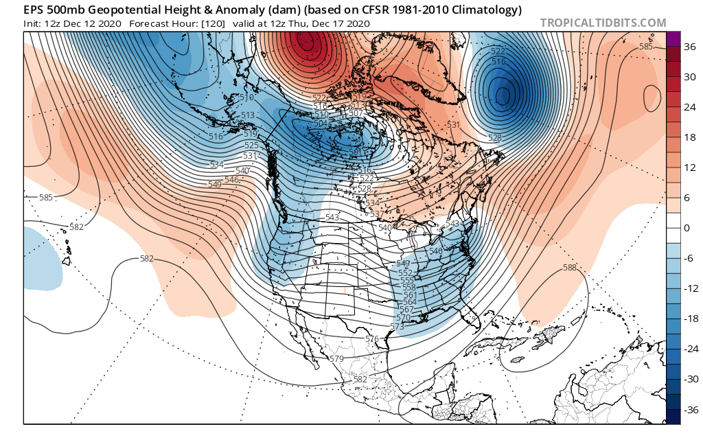
Above: the EPS (European Ensemble) depiction of the upper level pattern on Thursday morning. This is a textbook look for a winter storm in New England.
The Overall Setup As I mentioned in our Facebook update this morning, this is probably the best December winter storm pattern we've seen in quite some time. The image above is a snapshot of that pattern, but it's easy to see why I'm writing this post. If you recall in our winter forecast, we said that there might be a window for some teleconnection support. Here it is. You have higher heights (look toward the red shading) in the Arctic which reflect negative states of the NAO and AO, and in the Pacific, while not perfect, you have some ridging (raised lines) in the Pacific that helps cut off the flow of warm air. This is an evolving pattern. Which means while we're socked in with a cold rain today and tomorrow we will be warmer than normal, we will be dealing with our first potential system on Monday and likely second and much colder system by midweek, and maybe another system by the weekend. 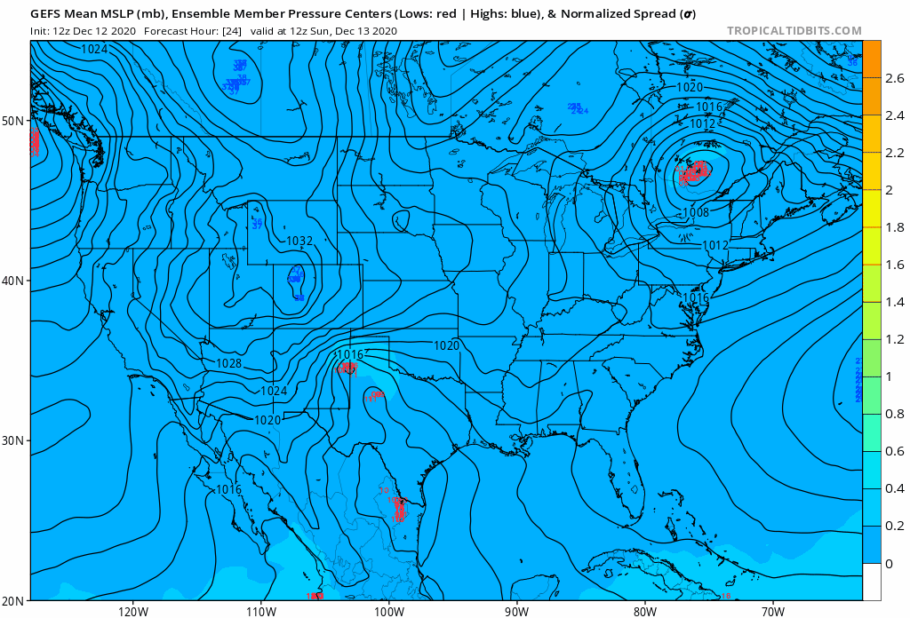
Above is the GEFS (GFS Ensembles) depicting our two main systems. The first comes on Monday and the next is looking more Wednesday PM into Thursday. Timing for the second is still up in the air. Note the areas of low pressure (red numbers) below CT. Both are good tracks for wintry precipitation for CT, though Monday doesn't have the best upper level setup.
Wave 1--Monday System
This first one is the classic thread the needle scenario not that much unlike our first winter storm earlier in December. We will see an area of low pressure develop in the south and slide off the coast on Monday. How far north it gets is critical to our chances for snow. Now, this one is a thread the needle setup because there isn't any real cold air in place to allow for an easy one type precipitation call, and we don't yet know the northern extent of the storm track. Small differences here can make a meaningful difference in what we see on Monday. This afternoon, the European model, which had been leading the way for a light snow event for CT backed down, while the GFS, which had been totally disinterested in any precipitation let alone snow in CT amped up to bring a period of snow for most of CT on Monday afternoon.
On the left you see a Monday whiff. We don't see any rain or snow on this run of the Canadian model. On the right, we have the 12z GFS, which was robust and drops a few inches in CT. The Euro, not shown, was in the middle. Note how even on the GFS, verbatim temperatures may be warm enough for rain at times.
Right now we think the snow ceiling is low for this system. A further south track means we see nothing. Further north and we could see a mix of rain and snow that has some accumulation, albeit minor. A lot needs to be sorted out here before we put out forecast numbers tomorrow. Regardless of what happens, Wave 1 is important. If you remember the very first image, to the northeast of Canada there is a huge blue ball. That's Wave 1! After it passes us it blows up into a huge system that provides blocking for our next system...
Wave 2--Wednesday/Thursday
Let me start off by saying there is higher confidence in Wave 2 than Wave 1. Why? Because the pattern will have matured enough to provide us with relatively stable features to support a potentially major winter storm. With Wave 1 and the teleconnections serving as a block, the next wave on the heels of Monday has a lot going for it. First, there's cold air in place. 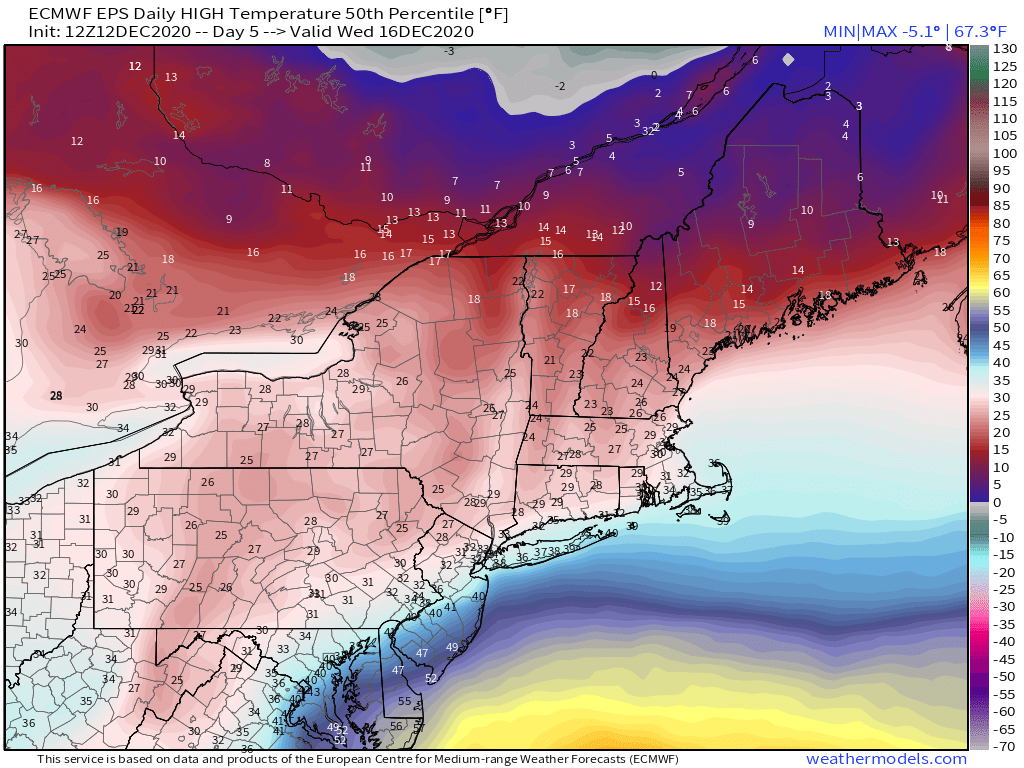
Above you'll see EPS (again, Euro Ensemble) high temperatures on Wednesday. It's near to below freezing across the state. This is important because unlike Wave 1, or the system in early December, there's an Arctic high to our north locking in cold air. This makes it less likely we see mixing issues even at the coast, though coastal folks really need to watch where this tracks to feel confident in snow type. Image courtesy of weathermodels.com.
Second, the dynamics of the storm are sound. 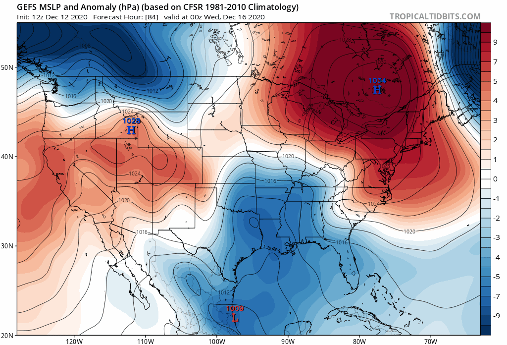
Let's walk through this GFS Ensemble image above. This covers Wave 2's progression. First, you will see a low (blue) develop in the south and then ride up the coast while deepening. That's a good track for a winter storm, near our "Benchmark", though a little south for our blockbuster storms. But note the high on top--that locks in our cold air and keeps the storm from cutting to our west. Timing matters quite a bit here, as well as the track. If the best dynamics take off to our south at the right location, watch out. If not, this is a more run of the mill type of storm.
Looking at some of the ensemble probabilities, there is a very strong signal for a significant snow event out of this. That said, we're still a ways out, and we need to see how Wave 1 impacts Wave 2. Now is not the time to lock in snow totals, no matter what you see on ensembles or operational guidance. 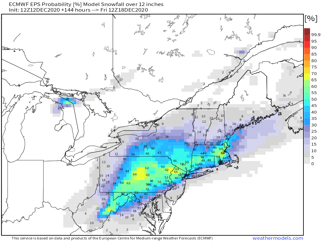
Above: the 12z EPS probabilities of 12+ inches between now and Friday morning. As of this run, it's a 40-50% probability for most, which may not seem like much, but is a huge signal for a significant winter weather event at this range. Image courtesy of weathermodels.com.
This could still end up less dynamic or shunted further south, but one thing is clear: Wave 2 has a high ceiling, statewide. Stay tuned. As always, please like, share, and interact with us on our social media--on Facebook to share our discussions, and follow us on Twitter @southernctwx to retweet our posts. Hit the buttons below to join. Thank you for reading. -DB |