Good evening from Southern Connecticut Weather!
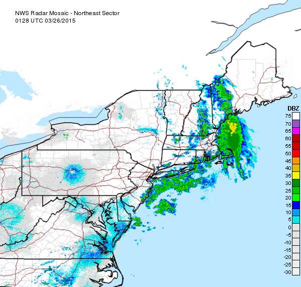
We’re seeing something we haven’t seen in a long time across the state tonight, that is, rain! We’ve got some scattered showers moving west to east across the state, bringing a round of light rain to much of the region. They should exit to the east overnight, and by tomorrow morning, we should be awaking to mostly cloudy skies, and we’ll be getting ready for some of the warmest temperatures we’ve seen in quite some time!
We’re seeing something we haven’t seen in a long time across the state tonight, that is, rain! We’ve got some scattered showers moving west to east across the state, bringing a round of light rain to much of the region. They should exit to the east overnight, and by tomorrow morning, we should be awaking to mostly cloudy skies, and we’ll be getting ready for some of the warmest temperatures we’ve seen in quite some time!
Tomorrow looks to be the first solidly above normal day in months as a warm front pushes north and brings temperatures of five to ten degrees above normal to the state tomorrow, corresponding to low to mid 50s for highs. Unfortunately, we won’t have sunshine to enjoy this with, as a round of rain pushes NE into the state tomorrow afternoon and lasts through the overnight into early Friday morning. This rain will be more widespread in coverage than what we saw this evening, and brings with it the possibility for some localized cells of heavier rain and perhaps even a thunderstorm or two as well. This, combined with snowmelt from warmer temperatures, will result in a risk for some flooding tomorrow afternoon into Friday morning, especially in areas with poor drainage.
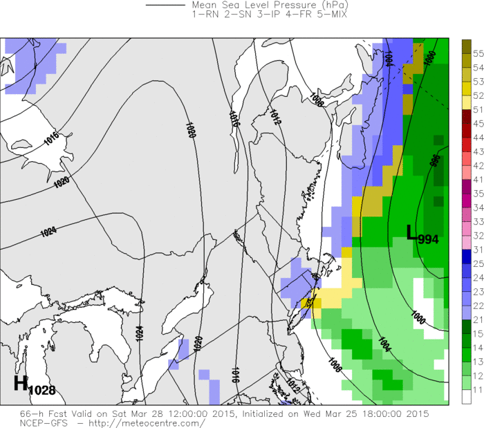
Rain moves out by Friday morning and leaves a mostly cloudy day in it’s wake, with a shot at some partial sunshine in the late afternoon. Temperatures will still be warm, however, with highs again approaching or crossing the fifty degree mark across most of the state. Don’t be fooled into thinking that Spring is here, however, as a cold front swoops into the state Friday night and drops expected highs for Saturday down into the mid to upper 30s, with again mostly cloudy skies. The GFS model along with some of it’s ensemble members suggest that we could see a small snow event on Saturday from an inverted trough that forms over the state, and the Canadian has hinted at a potentially bigger event that would bring widespread accumulating snow, but as of now, the model consensus is for a miss and I don’t see any reason to go against that in the forecast. Keep an eye on the updates though!
Rain moves out by Friday morning and leaves a mostly cloudy day in it’s wake, with a shot at some partial sunshine in the late afternoon. Temperatures will still be warm, however, with highs again approaching or crossing the fifty degree mark across most of the state. Don’t be fooled into thinking that Spring is here, however, as a cold front swoops into the state Friday night and drops expected highs for Saturday down into the mid to upper 30s, with again mostly cloudy skies. The GFS model along with some of it’s ensemble members suggest that we could see a small snow event on Saturday from an inverted trough that forms over the state, and the Canadian has hinted at a potentially bigger event that would bring widespread accumulating snow, but as of now, the model consensus is for a miss and I don’t see any reason to go against that in the forecast. Keep an eye on the updates though!
The weekend is not all lost, however, as we will see almost full sunshine on Sunday along with highs in the mid 40s, which while still below normal will feel beautiful compared to what we’ve been seeing the last few months! A perfect day for an early spring hike or a fun filled day on the slopes with soft snow and full sunshine. Get out there and enjoy it!
Moving into next week, another possible system looks to approach for Monday into Tuesday, but details on that are very murky. In general, it looks like a weaker, drier system, but given the time of year and the reliability of models this winter, everything should still be on the table. In the long run, it appears that our below normal pattern will continue at least through the beginning of April, although with every day that passes our climo normals get higher and we march into Spring more and more. Doesn’t mean we can’t get a late season snowbomb though, so winter lovers, it’s not over just yet!
As we’re moving into the off-season and away from the action of winter, it’s a good time to remind folks of our off-season routine. SCW operates year-round and will continue to do in 2015, but we scale back our posting schedule to 2-3x per week for forecast discussions due to the relative stability of summer forecasting, and often they are presented in a more abbreviated fashion(After all, there’s only so many ways that you can say 70s and sunshine J ). Of course, during times of possible severe weather(Generally when an outlook for severe thunderstorms has been issued by the SPC), we will have a forecaster on duty to post rapid-fire updates if and when severe storms develop, just like we do in the winter with our updates throughout snow events. We also will have more detailed coverage of any abnormal events that look to impact the area, for example if another hurricane or strong storm was a possibility in the forecast. We should have our summer outlook out sometime in May as well.
We also operate on a more limited staff during the summer, so please keep in mind that it may take us a day or two to get back to your emails/comments/messages. We promise you that we’ll get to them as soon as we see them! We plan on ramping up to daily operations for our fourth season of winter coverage in mid November, and are already looking forward to another winter of tracking, writing, observing, and enjoying the weather with you, our loyal readers!
In the next week or two, we’ll have a closing update on the winter where we look back at the winter as a whole, examine the statistics, and grade our winter forecast compared to reality. Until then, we’ll have our next discussion for you on Friday(Unless we run into some thunderstorms tomorrow afternoon in which case we will have rapid-fire coverage). Thanks for reading!
-SA
