
Good evening to you from Southern Connecticut Weather!
As Don mentioned yesterday, we’ve got an impressive storm system approaching the region for tomorrow into Wednesday. A strong cold front will slowly move across the region, bringing an end to both the warmth and dryness that we’ve seen over the past several weeks. To set the stage, here’s a look at the evolution of the upper air pattern over the next couple of days.
As Don mentioned yesterday, we’ve got an impressive storm system approaching the region for tomorrow into Wednesday. A strong cold front will slowly move across the region, bringing an end to both the warmth and dryness that we’ve seen over the past several weeks. To set the stage, here’s a look at the evolution of the upper air pattern over the next couple of days.
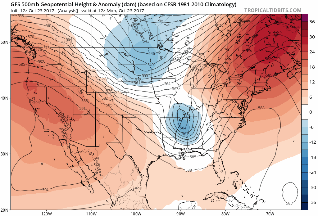
As you can see, we’ve currently got a strong ridge over the eastern seaboard(the source of our near record warm temperatures over the past several days) while a trough is developing to our west in the midwest and plains states. Over the next day or so, that trough strengthens to anomalously strong levels and slowly begins to move east, pushing the ridge out. In the process, a strong gradient between the ridge and the trough is realized, promoting instability across New England. Combine this with a strong lower level jet coming up from the tropics and the ingredients are all there for a period of heavy rain and strong winds from Tuesday through Wednesday.
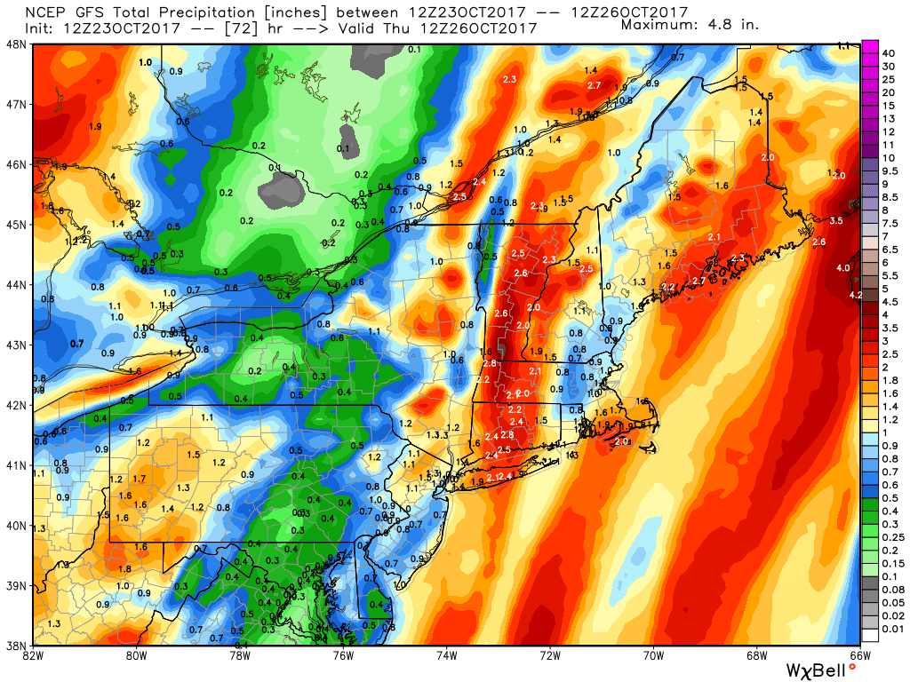
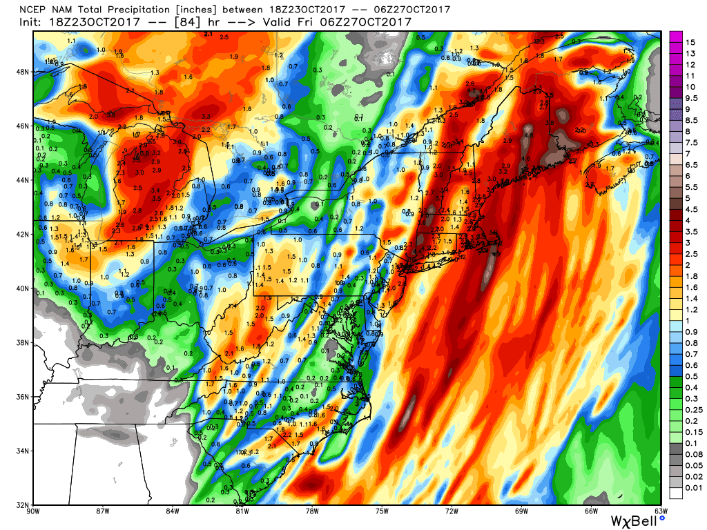
Let’s look at the rain first. The combination of a slow moving system and an anomalously wet airmass (meaning precipitation rates will be impressive) will promote the possibility of some flash flooding across the state for areas where stronger cells develop. As such, flash flood watches have been issued for Litchfield and Hartford counties where model guidance targets as being the most likely to see stronger banding, however, I would not be surprised to see those watches expanded in the overnight package.
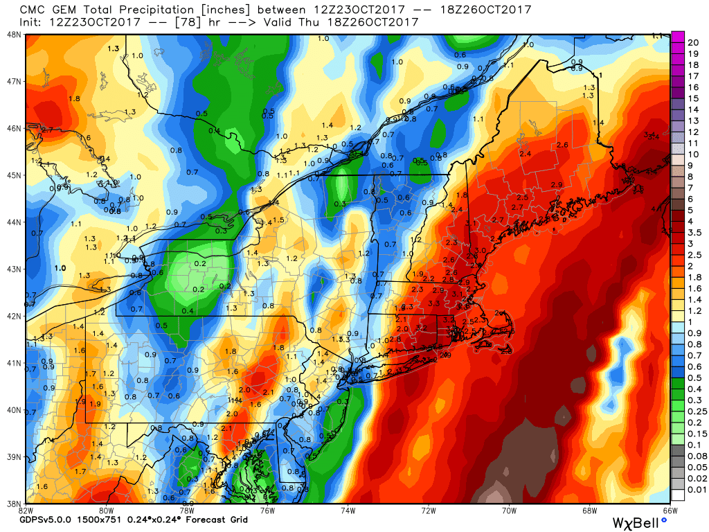
Total precipitation amounts look to be in the 1.5-2.5” range across most of the state. There will be a definite maximum towards the western end of the extent of heavy rain, where exactly that is depends on the progress of the trough and where it is eventually stalled out. Areas to the west of that eventual stall position will see comparatively little rain as there will not be sufficient time to rack up the big totals compared to those areas further east. While I think that dividing line will be west of the state, it’s worth noting that some models(most notably the canadian) have that line in our western zones. We’ll keep an eye on the trends and will update if the picture becomes clearer.
Here’s a look at total precipitation from the GFS, NAM and Canadian.
Let’s look at the rain first. The combination of a slow moving system and an anomalously wet airmass (meaning precipitation rates will be impressive) will promote the possibility of some flash flooding across the state for areas where stronger cells develop. As such, flash flood watches have been issued for Litchfield and Hartford counties where model guidance targets as being the most likely to see stronger banding, however, I would not be surprised to see those watches expanded in the overnight package.
Total precipitation amounts look to be in the 1.5-2.5” range across most of the state. There will be a definite maximum towards the western end of the extent of heavy rain, where exactly that is depends on the progress of the trough and where it is eventually stalled out. Areas to the west of that eventual stall position will see comparatively little rain as there will not be sufficient time to rack up the big totals compared to those areas further east. While I think that dividing line will be west of the state, it’s worth noting that some models(most notably the canadian) have that line in our western zones. We’ll keep an eye on the trends and will update if the picture becomes clearer.
Here’s a look at total precipitation from the GFS, NAM and Canadian.
Strong winds are also a threat with this system due to the strong LLJ, with gusts up to the 50 MPH range possible in the stronger cells. To cover this, a wind advisory has been posted for the entire state(except northern Fairfield and New Haven counties, which should be included in my opinion) for tomorrow afternoon through Wednesday morning. There is also some convective threat, with strong winds and a very isolated chance of a tornado possible, causing the SPC to issue a slight risk for the western half of the state and a marginal risk for the eastern half.
As far as a timeline goes, look for light rain to move into the state tomorrow morning and last throughout much of the day tomorrow. The bulk of the precipitation along with the strongest winds will come after dark tomorrow night and last through Wednesday morning before tapering to scattered showers later on Wednesday. Should be mostly dry by Thursday morning aside from perhaps a residual shower or two. Here's a simulated radar from the NAM showing the systems modeled progression.
As far as a timeline goes, look for light rain to move into the state tomorrow morning and last throughout much of the day tomorrow. The bulk of the precipitation along with the strongest winds will come after dark tomorrow night and last through Wednesday morning before tapering to scattered showers later on Wednesday. Should be mostly dry by Thursday morning aside from perhaps a residual shower or two. Here's a simulated radar from the NAM showing the systems modeled progression.

Behind the system, it looks like the unsettled period continues, with seasonable to above normal temperatures through the end of the week before another potential system arrives for later next weekend or early next week. More on that in due time!
Stay dry and thanks for reading SCW!
-SA
Stay dry and thanks for reading SCW!
-SA
