Disc: The header says it all! The same overall weather pattern is expected to continue unabated for at least the next week or two. A generally humid wx pattern will be in place w/frequent chances of t-storms. Not too atypical for summer. The only thing that has been rather atypical is the direction of movement of these storms recently.
Currently: Any chance for convective development today is on the wane. If we were going to get any storms, by this point, we should have at least seen some initiation. One lone cell has developed over Dutchess County, NY, but even if this cell does something, it would stay well W of the area.
Tonight: As I just mentioned, while a thunderstorm is not completely impossible, the ship has basically sailed with regards to convective development today, so the chance is very close to zero. As far as temps are concerned, on a warm, humid, stormless summer night, there really is never a reason to quibble with guidance, so I will accept it at face value. Look for lows only around 70.
Tomorrow: A backdoor cold front approaches from the NE. On hot summer days, esp summers where the really hot guidance has not worked well, I make a checklist of what can go wrong with heat? Tmrw's checklist contains a lot. First, the backdoor cold front itself shud swing winds around to the NE by ery aftn. Secondly, thunderstorms associated w/that backdoor front will head to the area. I think t-storms shud be numerous, as there is good heating ahead of the front and a sharp thermal contrast, as well as good atmospheric convergence. W/all this in mind, I've chopped a few deg off guidance for tmrw. Look for highs genly 80-85, altho a few spots alg I 91 could surpass 85 briefly.
I have taken the executive decision to separate the fourth of July weekend forecast from the rest of the long term (and mid term) sections today. I have decided to consider all chances of t-storms thusly: On Saturday, I feel the air mass will be too stable to really get any convection going on the heels of the back door cold frontal passage and a marine layer entrenched in place. So expect a fairly nice day on Sat, with temps a couple degrees below normal. I have gone a couple deg blo guidance temps for Sat. I think the NBM temp guidance is being contaminated by a few members that do not recognize onshore flow. Therefore, xpct high temps around 80 degrees, maybe even a cpl deg cooler alg the immediate S coast.
For Sunday, the backdoor cold front will move back Northeast as as warm front, but become stuck over Ern CT as it begins to undergo "frontoloysis"- the death of a front. Therefore, I have done something with chances of thunderstorms on Sun that is very rare- showing the highest chances over Eastern CT and little or no chance at all up in the NW hills. I have genly gone a bit above guidance for high temps, but I am probably too warm in Ern CT, where there will be more clouds and pcpn. Look for highs in the mid to upper 80s, but cooler in areas that do not break out into sun.
For anyone who has Monday off, congratulations! Now, for the weather... models have trended faster with an approaching cold front... fast enough to bring storms back to the region by later Monday afternoon. There is no clear cut signal at this time as to one area being favored over another, so just numerous showers & storms for now until a signal becomes more clear one way or the other. As for temps, I've gone 3-5 degs above guidance. In this instance, I think some NBM members think the backdoor cold front may still exist, but by then it should have long since dissipated. Anyway, based on all of this, look for highs close to 90, maybe even a deg or two warmer near I 91!
Longer Term (Tue- Thu): This is another unsettled period, in which it will be hard to time the various waves that will produce shower and storm chances. Right now, although this can certainly change, the day with the highest chance is Wed, and the day with the lowest chance is Thu. But that most certainly can chg.
For Tue, I believe there is a slight chance of storms in the entire state, except the NW Hills, believe it or not. There are two axes of instability: one is to our southwest, which may be close enough to clip SW CT, and another is the sea breeze, which does not affect the NW Hills, and that is the basis for this forecast.
For Wed, this appears to be the best chance of showers and storms, as of now, with a frontal zone near the area. I layered the chances pretty much according to climatology. This means the highest chances W of I 91.
For Thu, I kept all chances of storms out of the forecast for now, both due to the fact that it is day 7, and right now, models are dry. Although this is not to say that I am 100% certain that Thu will be totally dry. It is kind of ironic that based on today's modeling, this week and next week may turn out to have the hottest (and least stormiest day be Thu)!
As for temperatures through this period, with some storm chances on Tuesday and Wednesday, I stayed close to guidance. For Thu, I went a few degrees above guidance, due to the fact that I think we're high & dry, but that could change. So I went w/the following for highs: upper 80s thruout on Tue, near 90 for most Wed, but cooler in the NW HIlls where I hv the highest storm chcs. Near 90 also for most on Thu, but maybe some low 90s for the I 91 corridor, where it warms up really well.
Looking into the long range, ignoring the hot bias that some long range models have shown in the long range, a lot of the pattern looks very similar. There's a very good signal for some type of significant storm system in the Jul 11-12 (next weekend) time frame, involving a stalling front and some type of waves of low press developing along it, so we'll see. Other than that, the pattern looks to remain largely the same.
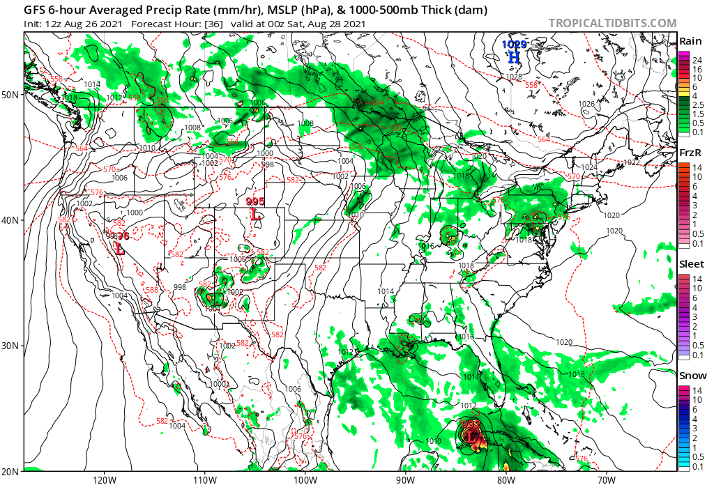
Now, let's look graphically at some systems slated to affect the area in the next week. First, here is tomorrow's backdoor frontal passage. On this map, you can see the front pretty much bisects CT. I like to use the red 570 thickness line as an approximate position. T-storms on this map are moving NE-SW and have ended in NE CT, but are ongoing everywhere else. This is valid around dinner time tmrw.
Currently: Any chance for convective development today is on the wane. If we were going to get any storms, by this point, we should have at least seen some initiation. One lone cell has developed over Dutchess County, NY, but even if this cell does something, it would stay well W of the area.
Tonight: As I just mentioned, while a thunderstorm is not completely impossible, the ship has basically sailed with regards to convective development today, so the chance is very close to zero. As far as temps are concerned, on a warm, humid, stormless summer night, there really is never a reason to quibble with guidance, so I will accept it at face value. Look for lows only around 70.
Tomorrow: A backdoor cold front approaches from the NE. On hot summer days, esp summers where the really hot guidance has not worked well, I make a checklist of what can go wrong with heat? Tmrw's checklist contains a lot. First, the backdoor cold front itself shud swing winds around to the NE by ery aftn. Secondly, thunderstorms associated w/that backdoor front will head to the area. I think t-storms shud be numerous, as there is good heating ahead of the front and a sharp thermal contrast, as well as good atmospheric convergence. W/all this in mind, I've chopped a few deg off guidance for tmrw. Look for highs genly 80-85, altho a few spots alg I 91 could surpass 85 briefly.
I have taken the executive decision to separate the fourth of July weekend forecast from the rest of the long term (and mid term) sections today. I have decided to consider all chances of t-storms thusly: On Saturday, I feel the air mass will be too stable to really get any convection going on the heels of the back door cold frontal passage and a marine layer entrenched in place. So expect a fairly nice day on Sat, with temps a couple degrees below normal. I have gone a couple deg blo guidance temps for Sat. I think the NBM temp guidance is being contaminated by a few members that do not recognize onshore flow. Therefore, xpct high temps around 80 degrees, maybe even a cpl deg cooler alg the immediate S coast.
For Sunday, the backdoor cold front will move back Northeast as as warm front, but become stuck over Ern CT as it begins to undergo "frontoloysis"- the death of a front. Therefore, I have done something with chances of thunderstorms on Sun that is very rare- showing the highest chances over Eastern CT and little or no chance at all up in the NW hills. I have genly gone a bit above guidance for high temps, but I am probably too warm in Ern CT, where there will be more clouds and pcpn. Look for highs in the mid to upper 80s, but cooler in areas that do not break out into sun.
For anyone who has Monday off, congratulations! Now, for the weather... models have trended faster with an approaching cold front... fast enough to bring storms back to the region by later Monday afternoon. There is no clear cut signal at this time as to one area being favored over another, so just numerous showers & storms for now until a signal becomes more clear one way or the other. As for temps, I've gone 3-5 degs above guidance. In this instance, I think some NBM members think the backdoor cold front may still exist, but by then it should have long since dissipated. Anyway, based on all of this, look for highs close to 90, maybe even a deg or two warmer near I 91!
Longer Term (Tue- Thu): This is another unsettled period, in which it will be hard to time the various waves that will produce shower and storm chances. Right now, although this can certainly change, the day with the highest chance is Wed, and the day with the lowest chance is Thu. But that most certainly can chg.
For Tue, I believe there is a slight chance of storms in the entire state, except the NW Hills, believe it or not. There are two axes of instability: one is to our southwest, which may be close enough to clip SW CT, and another is the sea breeze, which does not affect the NW Hills, and that is the basis for this forecast.
For Wed, this appears to be the best chance of showers and storms, as of now, with a frontal zone near the area. I layered the chances pretty much according to climatology. This means the highest chances W of I 91.
For Thu, I kept all chances of storms out of the forecast for now, both due to the fact that it is day 7, and right now, models are dry. Although this is not to say that I am 100% certain that Thu will be totally dry. It is kind of ironic that based on today's modeling, this week and next week may turn out to have the hottest (and least stormiest day be Thu)!
As for temperatures through this period, with some storm chances on Tuesday and Wednesday, I stayed close to guidance. For Thu, I went a few degrees above guidance, due to the fact that I think we're high & dry, but that could change. So I went w/the following for highs: upper 80s thruout on Tue, near 90 for most Wed, but cooler in the NW HIlls where I hv the highest storm chcs. Near 90 also for most on Thu, but maybe some low 90s for the I 91 corridor, where it warms up really well.
Looking into the long range, ignoring the hot bias that some long range models have shown in the long range, a lot of the pattern looks very similar. There's a very good signal for some type of significant storm system in the Jul 11-12 (next weekend) time frame, involving a stalling front and some type of waves of low press developing along it, so we'll see. Other than that, the pattern looks to remain largely the same.
Now, let's look graphically at some systems slated to affect the area in the next week. First, here is tomorrow's backdoor frontal passage. On this map, you can see the front pretty much bisects CT. I like to use the red 570 thickness line as an approximate position. T-storms on this map are moving NE-SW and have ended in NE CT, but are ongoing everywhere else. This is valid around dinner time tmrw.
On the next map, you can see a frontal boundary near the area, and numerous showers and storms really all over the Northeast. This is valid late Mon afternoon.

Anyway, that's all for now! Stay safe and enjoy the 4th!
-GP!
-GP!
