A Bermuda high pressure system will be in control of our weather this week. This means temperatures largely above normal, with slight chances of showers and thunderstorms most days.
Currently: A weak, quasistationary front straddled the northern edge of the state, with weak low pressure near Bennington, Vermont. This front was in the process of undergoing frontolysis, or the death of a front. In response to this front, a thunderstorm popped up over the NW Hills. Widely scattered thunderstorms will be possible until sunset. High pressure also stretched from the Appalachians to the Great Lakes.
Tonight: There may be some radiational cooling, but most of it will be tempered by higher humidity. As a result, even if I go a degree or two lower than guidance, lows should only be around 70. A weak wave may trigger a thunderstorm toward morning, with the highest chances in the SW.
Tomorrow: Guidance temperatures look good, and they are hot. With sunshine, after any morning storms an clouds clear, highs should be around 90 statewide. There is a slight chance of thunderstorms later in the day, especially in the NW Hills.
Tomorrow Night/Thursday: Hot weather continues. Really not much change to the forecast. A small chance of thunderstorms during the heat of the day. Hot, with highs around 90 statewide, although I could see the immediate SE coast being cooler. This time it appears the best chance of diurnal thunderstorms will be in NE CT, as there is a better trigger there.
Long Term (the weekend and beyond): Friday may very well be the hottest day of the forecast period and one of, if not the, hottest day(s) of the summer. Once again, there will be just a slight chance of diurnal thunderstorms, with the highest chances being in the NE. High temperatures on Friday should soar, reaching 90 at the coast to 95 in the I 91 corridor (N of the Merritt Pkwy).
On Saturday, a weak cold front will have cleared the state, so it will be slightly cooler, with highs in the mid 80s. A warm front returns later Saturday night. The entire state should be dry during the day. However, late at night, heavy thunderstorms associated with the front should creep into the SW part of the state.
For Sunday, after any morning storms clear, humidity will stay high, and more storms will flare up durinf the afternoon and evening, and once again, should be heavy. Due to clouds and storms, highs on Sunday should only be 80-85, but it will be a very uncomfortable 80-85, with very high levels of humidity.
Monday could be a legitimate threat of severe thunderstorms. It will be quite hot again, with highs near 90 degrees statewide. A strong cold front approaches late in the day, and this front should trigger a squall line of showers and thunderstorms. Obviously, at this juncture, timing could go wrong, and timing is important with a cold front, regarding severe weather potential. But at this point, it looks like a very good severe weather threat.
Tuesday will feature more pleasant weather behind the cold front, with just a slight chance of a morning thunderstorm, depending on how long the front takes to completely clear the state. High temperatures on Tuesday should be 80-85, and it will be a more comfortable 80-85, as humidity levels lower behind the front.
Long Range: There still does not look to be any huge impetus for a pattern change from what we've seen most of the summer in the long range- generally stormy, with hot weather when there aren't storms, and average or even occasionally below average temperatures on stormy days.
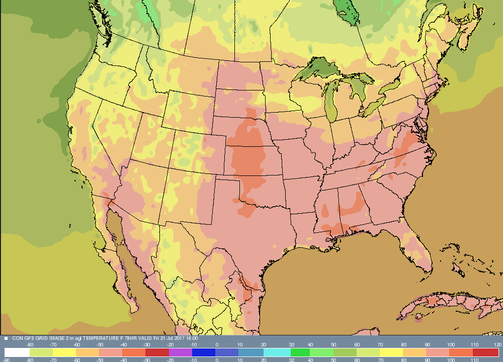
Now, let's take a look at some of the systems that will affect the state, in graphical format. We'll do something a little different today. SInce the main weather issue in this forecast period isn't until Monday, I'll post that as a precipitation map, and we'll highlight Friday's high temperatures. This map is valid early afternoon, Friday, with still a couple hours of heating to go! You can see all of the state is above 90 degrees, except the NW Hills, and there is little evidence of a sea breeze.
Currently: A weak, quasistationary front straddled the northern edge of the state, with weak low pressure near Bennington, Vermont. This front was in the process of undergoing frontolysis, or the death of a front. In response to this front, a thunderstorm popped up over the NW Hills. Widely scattered thunderstorms will be possible until sunset. High pressure also stretched from the Appalachians to the Great Lakes.
Tonight: There may be some radiational cooling, but most of it will be tempered by higher humidity. As a result, even if I go a degree or two lower than guidance, lows should only be around 70. A weak wave may trigger a thunderstorm toward morning, with the highest chances in the SW.
Tomorrow: Guidance temperatures look good, and they are hot. With sunshine, after any morning storms an clouds clear, highs should be around 90 statewide. There is a slight chance of thunderstorms later in the day, especially in the NW Hills.
Tomorrow Night/Thursday: Hot weather continues. Really not much change to the forecast. A small chance of thunderstorms during the heat of the day. Hot, with highs around 90 statewide, although I could see the immediate SE coast being cooler. This time it appears the best chance of diurnal thunderstorms will be in NE CT, as there is a better trigger there.
Long Term (the weekend and beyond): Friday may very well be the hottest day of the forecast period and one of, if not the, hottest day(s) of the summer. Once again, there will be just a slight chance of diurnal thunderstorms, with the highest chances being in the NE. High temperatures on Friday should soar, reaching 90 at the coast to 95 in the I 91 corridor (N of the Merritt Pkwy).
On Saturday, a weak cold front will have cleared the state, so it will be slightly cooler, with highs in the mid 80s. A warm front returns later Saturday night. The entire state should be dry during the day. However, late at night, heavy thunderstorms associated with the front should creep into the SW part of the state.
For Sunday, after any morning storms clear, humidity will stay high, and more storms will flare up durinf the afternoon and evening, and once again, should be heavy. Due to clouds and storms, highs on Sunday should only be 80-85, but it will be a very uncomfortable 80-85, with very high levels of humidity.
Monday could be a legitimate threat of severe thunderstorms. It will be quite hot again, with highs near 90 degrees statewide. A strong cold front approaches late in the day, and this front should trigger a squall line of showers and thunderstorms. Obviously, at this juncture, timing could go wrong, and timing is important with a cold front, regarding severe weather potential. But at this point, it looks like a very good severe weather threat.
Tuesday will feature more pleasant weather behind the cold front, with just a slight chance of a morning thunderstorm, depending on how long the front takes to completely clear the state. High temperatures on Tuesday should be 80-85, and it will be a more comfortable 80-85, as humidity levels lower behind the front.
Long Range: There still does not look to be any huge impetus for a pattern change from what we've seen most of the summer in the long range- generally stormy, with hot weather when there aren't storms, and average or even occasionally below average temperatures on stormy days.
Now, let's take a look at some of the systems that will affect the state, in graphical format. We'll do something a little different today. SInce the main weather issue in this forecast period isn't until Monday, I'll post that as a precipitation map, and we'll highlight Friday's high temperatures. This map is valid early afternoon, Friday, with still a couple hours of heating to go! You can see all of the state is above 90 degrees, except the NW Hills, and there is little evidence of a sea breeze.
The next image will show the severe thunderstorm potential for Monday. On this map, you can see a decent squall line for this part of the country, moving through western Connecticut, headed for the rest of the state. Other showers and thunderstorms are still lingering in PA and NJ, and that's why I have a slight chance in the forecast into Tuesday morning.

That is all for now! Enjoy the rest of your week and stay cool!
-GP!
-GP!
