Good afternoon from Southern Connecticut Weather!
Winter is firmly in place, and the active pattern continues as we turn our eyes to a system that is expected to begin impacting our area as early as tomorrow. Continuing the trend of relatively minor events, what once looked like a bigger potential item has trended warmer on the major guidance. With the GFS and Euro more aligned this afternoon, I have higher confidence in a low to moderate (hill towns) impact event. Here are some of the top line takeaways as of this post:
Winter is firmly in place, and the active pattern continues as we turn our eyes to a system that is expected to begin impacting our area as early as tomorrow. Continuing the trend of relatively minor events, what once looked like a bigger potential item has trended warmer on the major guidance. With the GFS and Euro more aligned this afternoon, I have higher confidence in a low to moderate (hill towns) impact event. Here are some of the top line takeaways as of this post:
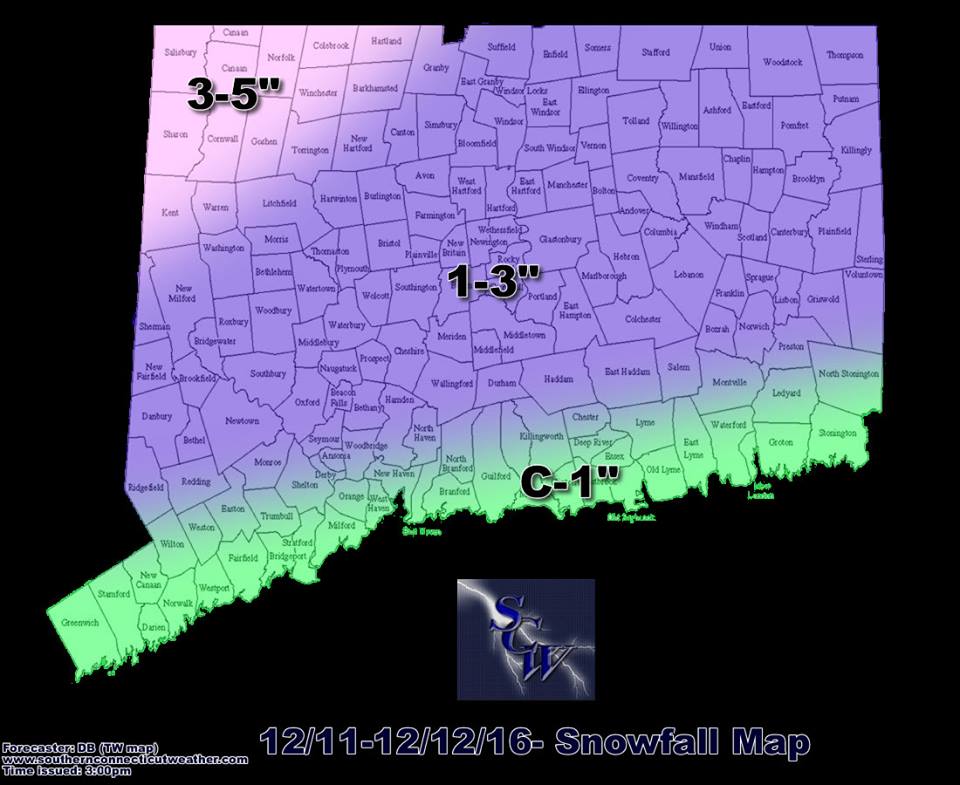
- The recent trends combined with the weekend timing have reduced the likelihood of this being a high impact event.
- We expect light snow to begin everywhere tomorrow afternoon and evening, with more moderate snow toward the evening and overnight hours.
- The expectation is that snow will transition to rain by the early Monday morning, but with temperatures still hovering near freezing, I expect slick spots and delays through the Monday morning commute.
- By mid-morning, everyone should be seeing a cold rain.
The overall setup is fairly simple. An area of low pressure out in the Midwest will be traveling to our north, but with cold air in place, we’ll see a period of snow that transitions to plain rain as the surface and column above warm. In this situation, I see snow and rain, rather than sleet or freezing rain, being the main precipitation types.
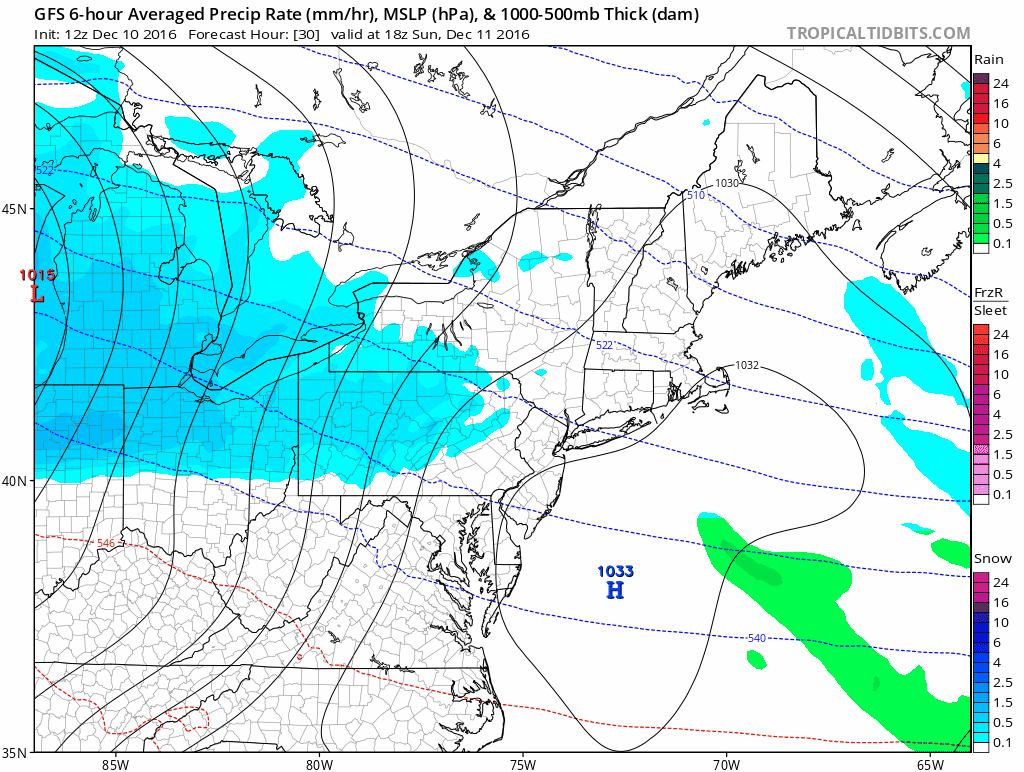
Here, the 12z GFS shows the low passing to our north, bringing a period of snow followed by rain.
One of the main questions that remain are temperatures. I think that temperatures for most of the state are more or less going to go the way of the major models, but scouring out the cold air in northwest Connecticut always seems to be tricky. We saw this with the latest run of the RGEM, one of our short range high resolution favorites, which gave me a little pause. The longer the column can stay below freezing up there, the more impactful this system will be. This season, it seems like the trend has been for the northwest areas to overperform, so I think folks up there should be prepared for a spot or two that ends up with more snow that currently forecast. That said, I think everyone shifts to rain by mid-morning at the latest.
One of the main questions that remain are temperatures. I think that temperatures for most of the state are more or less going to go the way of the major models, but scouring out the cold air in northwest Connecticut always seems to be tricky. We saw this with the latest run of the RGEM, one of our short range high resolution favorites, which gave me a little pause. The longer the column can stay below freezing up there, the more impactful this system will be. This season, it seems like the trend has been for the northwest areas to overperform, so I think folks up there should be prepared for a spot or two that ends up with more snow that currently forecast. That said, I think everyone shifts to rain by mid-morning at the latest.
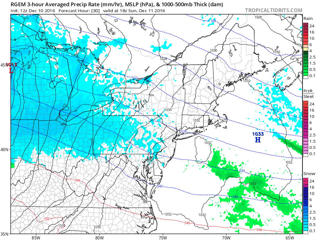
RGEM depiction of the coming event. Note that it has snow hanging on in the northwest hills through the rush hour, which increases the risk of a higher impact event up there. For the rest of us, I expect icy conditions early, but things will gradually improve as we transition to rain and temperatures at the surface rise.
Timing
In terms of timing, I think onset will be a tad slower than usual, with snow to beginning to break out as early as 4 or 5pm in southwest Connecticut and as late as 9 or 10pm in the far northeast portion of the state. The changeover should begin between 3-5am along the shore and as I mentioned before, the rest of the state should be rain by mid-morning. The rain will continue however, and I expect that to last through the middle of the afternoon.
Overall
Overall the timing and trend make this a nuisance event more than anything for Connecticut, but the northwest corner of the state will likely see another meaningful event, and should be prepared for the potential of significant delays. For the rest of the state, I think delays are more likely the further north you are.
Thank you for reading! Please like, share, and ask questions. Like and follow us on Facebook and Twitter @SouthernCTWX as we continue to follow this, the coming Arctic blast, and maybe another event by the weekend…
-DB
