Good morning from Southern Connecticut Weather.
This one has risk written all over it. As a forecaster, having confidence in your prediction is often based on the stability of trends in the modeled environment and guidance itself. In this instance, we've seen a significant trend toward more impactful in the last 36 hours. We started with a minor to moderate event, and with the forecast you will see below, we now see something solidly moderate for many with even higher upside if things come together. Let's jump right in.
This one has risk written all over it. As a forecaster, having confidence in your prediction is often based on the stability of trends in the modeled environment and guidance itself. In this instance, we've seen a significant trend toward more impactful in the last 36 hours. We started with a minor to moderate event, and with the forecast you will see below, we now see something solidly moderate for many with even higher upside if things come together. Let's jump right in.
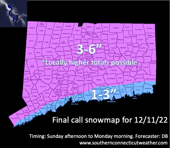
Above: the final call for CT with this system. This is a compromise between the very aggressive high resolution guidance, which has been showing a wide swath of warning level (6"+) snows and the more tempered global guidance (Euro/GFS) which show less.
Snow Accumulation
We've upped the numbers because soundings continue to look very dynamic, increasing the potential and confidence in a period of moderate to heavy snow tonight. It's unclear just how much we will realize this potential and there will likely be winners and losers depending on the banding, which has jumped all over the place and basically touched every part of the state at least once through these model cycles.
For virtually all of interior CT (with the exception of far SE zones), we're going with a general 3-6". Expectations for folks in this zone should to hedge toward to lower to middle end of this zone, with a final accumulation of 3-5", but be prepared for an overperformer.
Some high resolution guidance is trying to paint a stripe of 8-10" for parts of the state. It's hard to completely buy with the Euro and GFS not going bigger (though the GFS did briefly last night) but I won't discount that a narrow zone most likely in northern CT surges past our upper range. As a result, we are including wording for locally higher amounts in our map.
For coastal CT and part of inland SE CT, the expectation is that some of the precipitation will be rain or a mix before changing to all snow. Even here however, do not let your guard down. We have less confidence in a solidly moderate event here, but that doesn't mean the potential isn't there. SW CT folks in particular need to watch for an overperformer. If there was an area that I'd be most worried about only seeing a coating or inch, it'd be right along the shoreline in SE CT.
|
|
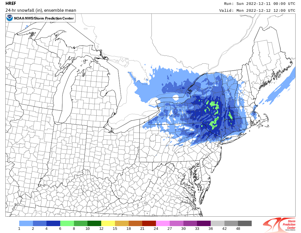
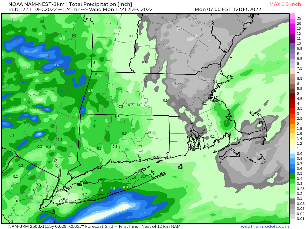
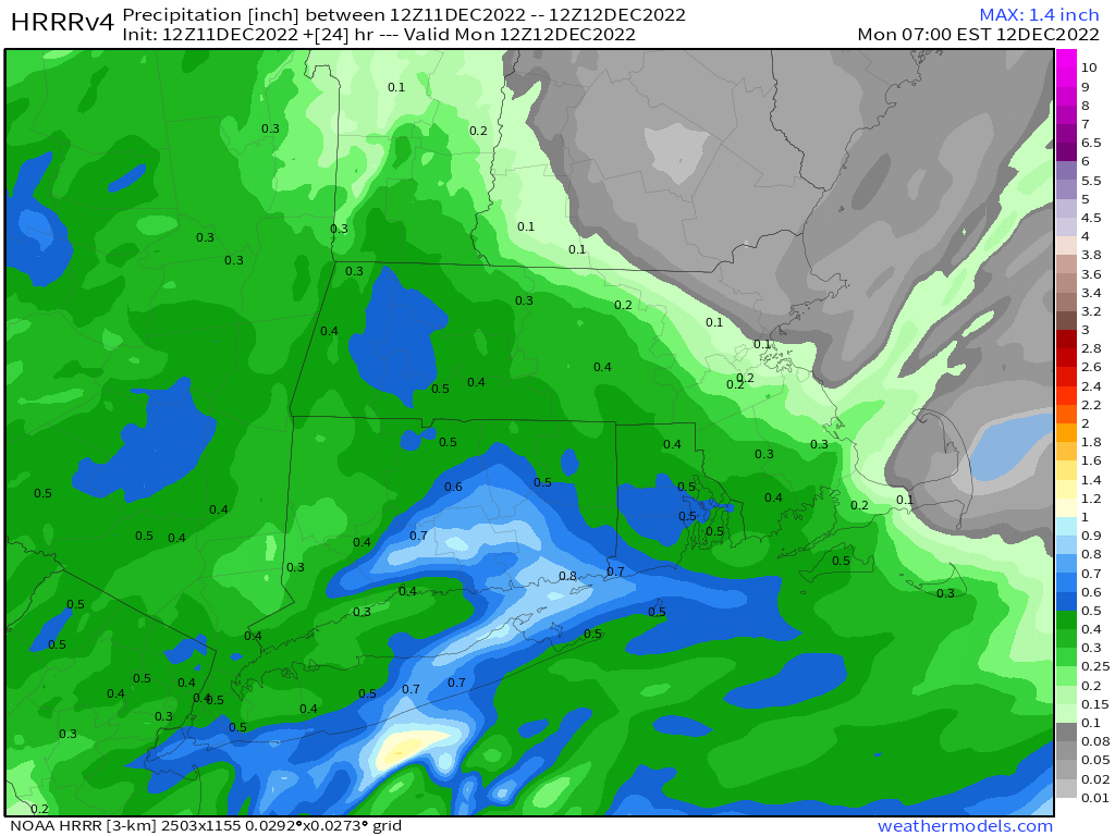
Above: A selection of high resolution guidance showing precipitation (top) and the HREF (bottom) showing a snowfall mean. The latest version of the HREF has not run yet as of this post. While there's upside looking at models like the HRRR, a blend is best here. Top images courtesy of weathermodels.com.
Timing
A quick look at the radar this morning shows that flurries may already be starting in spots, right on time with our post last night. Travel conditions look fine through the daylight hours, but snow will steadily get heavier this afternoon and especially after dark, so be careful on the roads. The heaviest is likely through the overnight period with it tapering off during the early morning hours. Snow should be done between 5-7am, but we will watch to see if an inverted trough sets up to prolong the snow tomorrow morning.
A quick look at the radar this morning shows that flurries may already be starting in spots, right on time with our post last night. Travel conditions look fine through the daylight hours, but snow will steadily get heavier this afternoon and especially after dark, so be careful on the roads. The heaviest is likely through the overnight period with it tapering off during the early morning hours. Snow should be done between 5-7am, but we will watch to see if an inverted trough sets up to prolong the snow tomorrow morning.
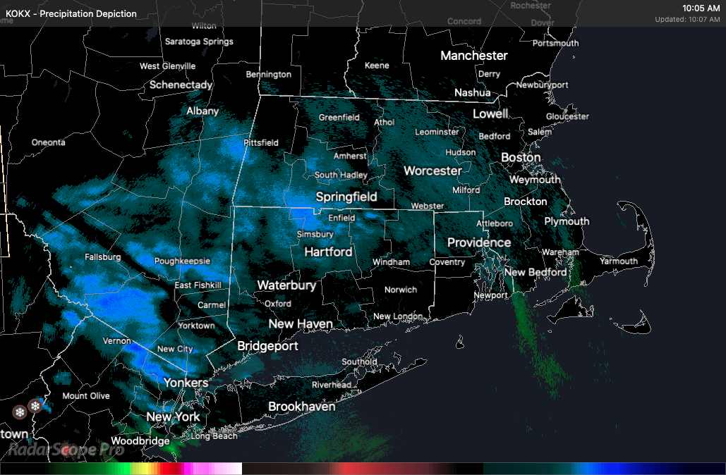
Above: Current radar image. It'll take time to saturate the column and bring in accumulating snow.
Impacts
For inland areas, 3-6 (and potentially higher) gets you into moderate event territory because it makes this a plowable event. Moderate to heavy snow will be possible this evening and into the overnight hours, before tapering off by daybreak. That's also important, because it means the timing of the heaviest will occur when roads are least traveled. This would be a higher impact event if it happened tomorrow.
That said, with a plowable event it increases the likelihood of school delays. Those may be widespread tomorrow. I think cancellations are unlikely except in the hardest hit areas, but we have to see how things play out. I don't expect any strong winds or significant power outages from this system.
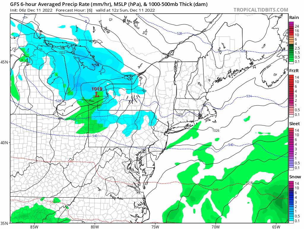
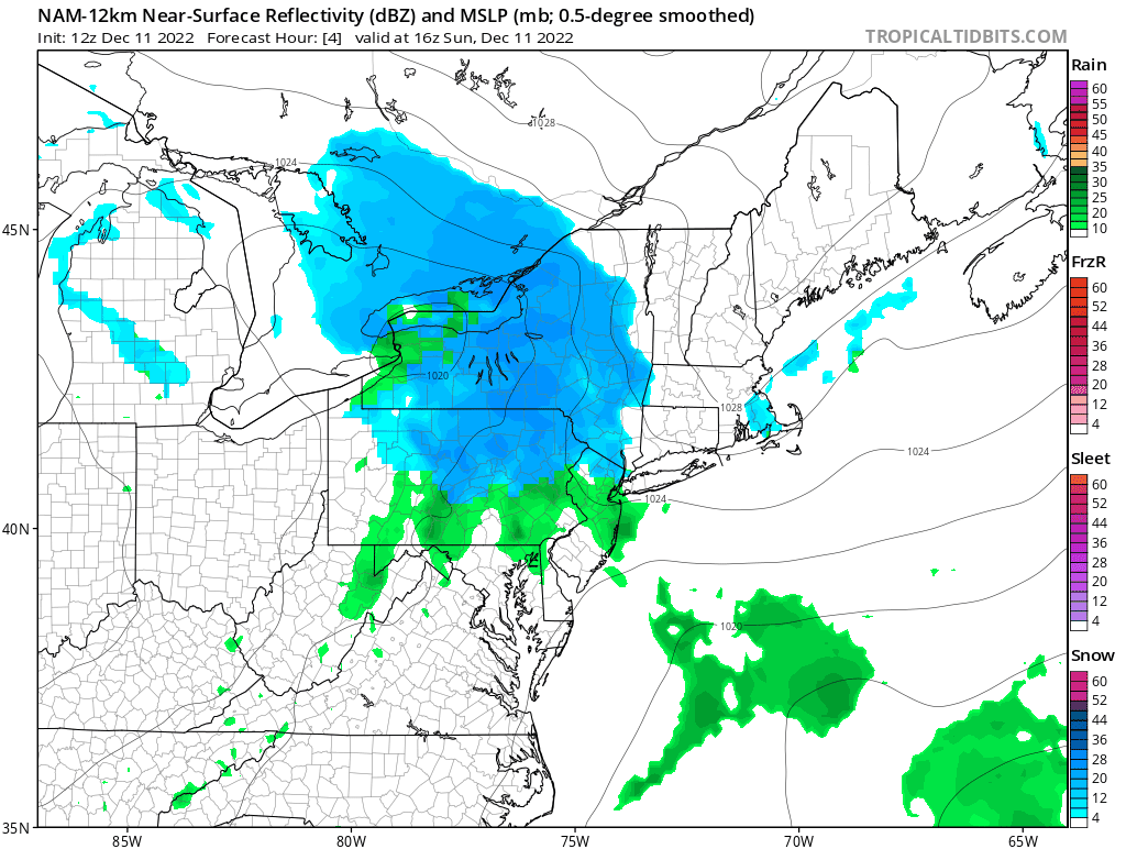
To illustrate the overall evolution of the system, here are loops of the GFS (top) which is one of the less bullish models, and the 12km NAM (bottom) which is one of the most bullish models.
Impacts
For inland areas, 3-6 (and potentially higher) gets you into moderate event territory because it makes this a plowable event. Moderate to heavy snow will be possible this evening and into the overnight hours, before tapering off by daybreak. That's also important, because it means the timing of the heaviest will occur when roads are least traveled. This would be a higher impact event if it happened tomorrow.
That said, with a plowable event it increases the likelihood of school delays. Those may be widespread tomorrow. I think cancellations are unlikely except in the hardest hit areas, but we have to see how things play out. I don't expect any strong winds or significant power outages from this system.
To illustrate the overall evolution of the system, here are loops of the GFS (top) which is one of the less bullish models, and the 12km NAM (bottom) which is one of the most bullish models.
Overall
This is one that's likely to produce a widespread plowable event of moderate impact. Most will end up with 1-3" at the shore and 3-5" inland, but there is significant upside potential in a narrow zone most likely in northern CT. This one is a quick hitter, and then we turn our attention to next week...
As always, please like, share, and interact with us on our social media--on Facebook to share our discussions, and follow us on Twitter @southernctwx to retweet our posts. Hit the buttons below to join.
Thank you for reading SCW.
-DB
