Good evening from Southern Connecticut Weather.
This is by far the most complicated forecast of the season.
We are less than 24 hours away from precipitation starting, and we have dramatic differences on the guidance regarding what will happen. After looking at the setup and all the data, it's time to make a call.
This is by far the most complicated forecast of the season.
We are less than 24 hours away from precipitation starting, and we have dramatic differences on the guidance regarding what will happen. After looking at the setup and all the data, it's time to make a call.
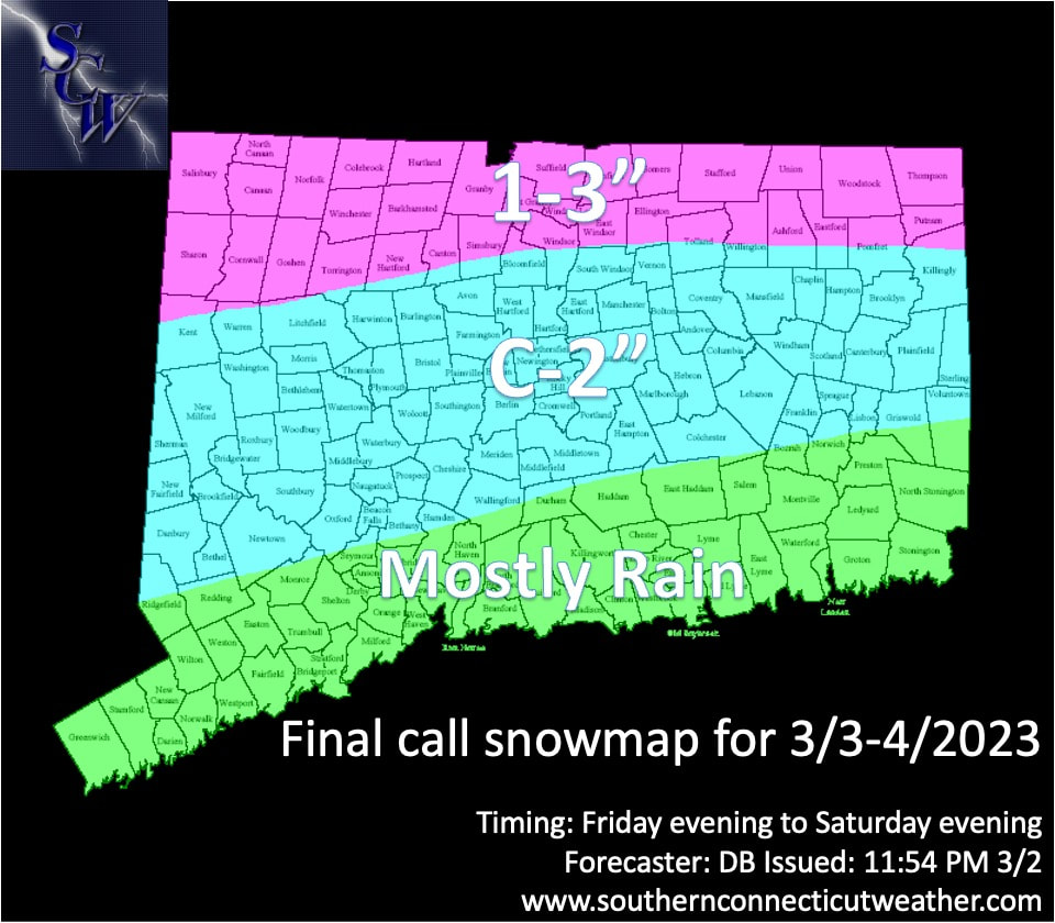
Above: our map for the Friday-Saturday event. For far southern CT, this is a minor to nonevent. For the middle third of the state, we're anticipating a minor snow accumulation, followed by sleet that changes to rain, especially in lower elevations. Here, it is a minor to moderate impact event. There may be a little snow on the back end, but we are not anticipating much. For the far northern portion of the state, we have the potential for the highest impact of snow changing to sleet and changing back to snow Saturday morning. This is where it is most likely to be a moderate impact event.
The Forecast
The setup at first glance looks fairly similar to earlier in the week, but there are two key differences: first, the antecedent airmass is not nearly as cold at the surface. We saw that earlier today with temperatures above normal. Even with high pressure to the north, there's no real low level cold to lock into the area like some of our more standard storms.
Second, the primary low near the Great Lakes is slower to transfer energy, to the coastal low, leading to a coastal hugger track that brings warmth aloft. That's how we go from snow to sleet...to rain.

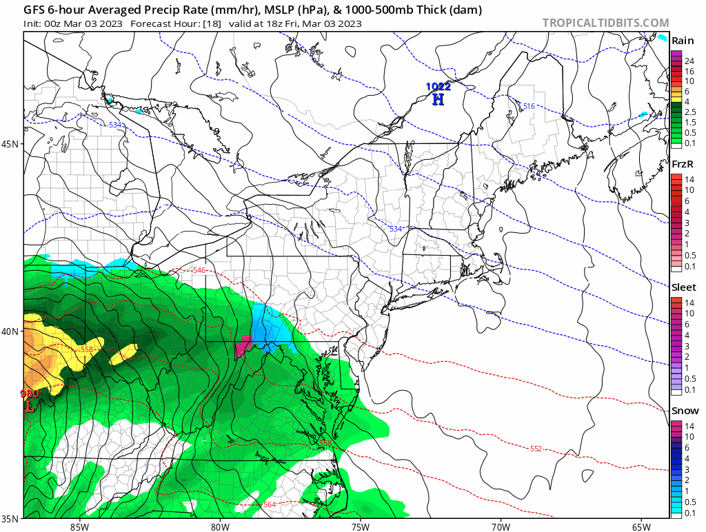
Above: the NAM, which is by far the warmest model. Note how even here we see sleet linger in NW CT.
Timing
It looks like we will see precipitation begin between 7-10pm on Friday, meaning that the school and 9-5pm work day is unlikely to be impacted by the weather. We will see precipitation come in from west to east, with snow likely starting for the entire state. For the shoreline, we will see a quick change from snow to sleet to rain. That's essentially the storm for you. Not a big deal. It's possible snowflakes fly as the storm departs Saturday morning and afternoon, but it shouldn't amount to anything meaningful. If the storm trends warmer, it'll just stay rain until the storm departs.
For our central zone, we will see snow and some accumulation. Overnight we expect a change to sleet. How long we sleet really depends on the track of the storm and extent of the warmth above the surface. In this zone, we think rain will fall eventually. We are more likely to flip back to a period of snow Saturday morning as the storm wraps up and departs in the afternoon. Like earlier in the week, the real accumulation is likely to occur before noon. A minor backend accumulation is possible.
For the northern zone, it's likely to stay frozen the entire time, even though the surface temperatures will hover near freezing. As a result, this is where the most accumulation and impact is likely.
Accumulation
This is going to be a messy storm. As the map above shows, we don't expect much in far southern CT. It's likely to be too warm at the surface and too warm aloft. Flakes and/or sleet should fall briefly Friday night, but things quickly change to rain. There may be some brief freezing rain, but we don't expect much.
For our central zone, we anticipate snow to start and accumulate on Friday. Accumulation is helped by the fact that this is happening after sunset. We are predicting a coating to two inches of snow, followed by an accumulation of sleet. The sleet accumulation may be significant, but keep in mind it doesn't accumulate as efficiently as snow. As a result, you could get a lot of sleet, but it only amounts to half an inch when measuring. The impact with sleet is slick roads and surfaces, along with much heavier shoveling. There may be some patchy freezing rain, but we think sleet is the real risk.
For the northern zone, snow hangs on the longest which means you are most likely to end up with a few inches of snow, followed by a significant accumulation of sleet. A change back to snow on Saturday could bring some minor accumulation, especially if temperatures remain below freezing. That's most likely in the NW hills.
Above: the 00z GFS, which is the coldest model. Like the NAM, it's an outlier, and we are blending guidance and looking at the antecedent conditions to develop our forecast.
Overall Impact
For our southernmost zone, this is a minor to nonevent. Because of the strength of the coastal low, we have coastal flood advisories and watches. If you are at the immediate shoreline, that's something to pay attention to. In addition, due to the strength of the low and gradient with the high to the north, we anticipate breezy conditions Friday through early Saturday. This shouldn't create major power issues in this zone because we don't anticipate significant snowfall or freezing rain, but we may see some minor tree and power line issues with maximum gusts on the order of 30-45mph.
For our central zone, this is a minor to moderate event. Should this trend colder, it's a more widespread moderate event due to more snowfall and sleet. If it warms like the NAM, it's minor at best for lower elevation areas. Winds will be slightly lower than the shoreline, and because we are looking at sleet over freezing rain and snow, we don't expect many tree and power issues.
For the northern zone, this is likely a moderate event, even though we don't see big snow. The snow combined with sleet and colder temperatures are likely to cause more road issues into early and midday Saturday. The winds are the least here, so again power outages are not a major concern.
Because this is such a tricky forecast, inland areas really need to watch for colder or warmer ticks. For now, we are hedging warmer looking at the lack of deep cold.
As always, please like, share, and interact with us on our social media--on Facebook to share our discussions, and follow us on Twitter @southernctwx to retweet our posts. Hit the buttons below to join.
Thank you for reading SCW.
-DB
