Good evening from Southern Connecticut Weather.
December is shaping up to be a battle between warmth and cold, with seesawing temperatures so far though broadly warmer than normal. We've been tracking this system for at least a week, and with it poised to impact Connecticut Flood Watches have been issued for the entire state. Let's take a look at this storm system, which now puts snow in the forecast for part of the state.
December is shaping up to be a battle between warmth and cold, with seesawing temperatures so far though broadly warmer than normal. We've been tracking this system for at least a week, and with it poised to impact Connecticut Flood Watches have been issued for the entire state. Let's take a look at this storm system, which now puts snow in the forecast for part of the state.
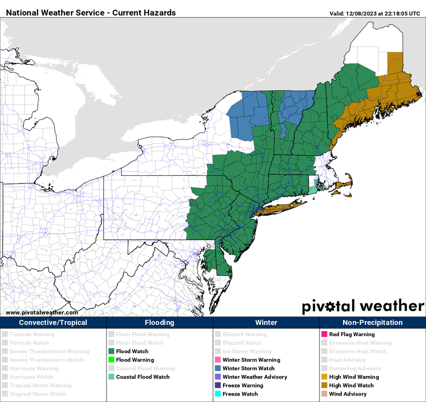
Above: the latest National Weather Service (NWS) watches and advisories for the state. For now, we only have a flood watch up for the entire state as heavy rain is expected Sunday into Monday.
The Overall Setup
This is worth a separate discussion during an insanely busy work week because we have multiple things we're tracking with this. While the signal for a storm has existed for a while, the details have waffled significantly, from originally showing a weekend washout, to shifting to a late Sunday/Monday system, to what we expect now, a wet Saturday afternoon into Monday with possible snow on the backside in the hills of CT, especially NW CT.
Essentially, a strong cold front will pass through the eastern US. The extent of the front is quite impressive and will bring colder air, but it isn't an Arctic front by any means. As the front reaches our region, we will see a storm develop along it, enhancing precipitation and wind while bringing heavy rain. As the front and storm pass to our east, we will see decreasing temperatures and possible snow on the backside for elevated areas of the state.
This is likely to be a significant winter weather event to our north and west, where climatology tends to be a little better for significant enough cold to allow for significant snow this time of year. Ski country rejoice. The timing of the low could even allow for snow all the way down to the DC region, illustrating the potential from this system.
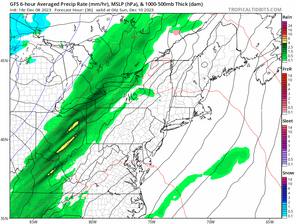
Above: the latest GFS model run through Sunday and Monday. Saturday continues to look fine, but Sunday now looks wet on balance with rain showers working into the state Sunday afternoon followed by heavy rain during the evening and overnight period.
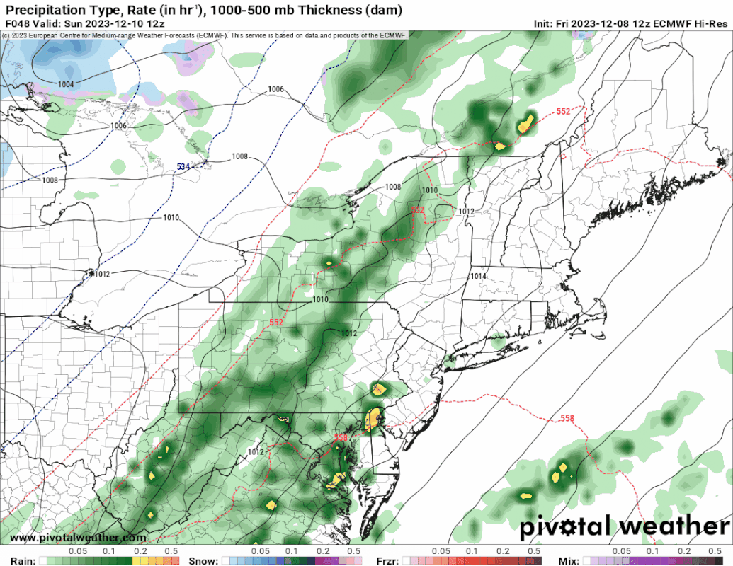
Below: the afternoon Euro model depiction. Note that just like the GFS there's a low riding along the front, with snow or mixed precipitation on the backside. Image courtesy of Pivotal Weather.
Below: the afternoon Euro model depiction. Note that just like the GFS there's a low riding along the front, with snow or mixed precipitation on the backside. Image courtesy of Pivotal Weather.
Timing & Impacts
As mentioned above, the timing has shifted back and forth.
Timing
Saturday is fine, but we now expect rain to move into the state by Sunday afternoon. It will be light at first, but the wind will pick up and heavy rain will move into the state over the course of the evening. The heaviest rain is likely overnight Sunday into Monday. Rain will taper off Monday morning into afternoon.
For higher elevation areas, any change to snow would happen on the tail end of the system on Monday.
Rain Impacts
The impact that we have most confidence in at this time is rainfall. This will likely be a heavy precipitation event, with the low enhancing the lift along the front. This means expect rainfall on the order of 2-3" on average with some spots possibly seeing higher amounts. This is why we have the flood watches.
Wind Impacts
Wind is likely to have an impact, but it's a little more uncertain how much wind we get to mix down. A stronger system would likely bring stronger wind. With leaves off most trees, this limits damaging wind potential. There will be a strong jet aloft with high winds, but a temperature inversion will likely keep much of that wind from maximizing wind potential over CT. It'll generally be windy Sunday and Monday, but we're really watching gusts. Currently, we think maximum gusts between 35-45mph occur inland and 40-50mph at the shoreline.
I wouldn't be surprised to see wind advisories hoisted at some point, and scattered power outages. The strongest wind zone currently looks like eastern and SE CT. Stronger winds are expected to be east of Connecticut.
Snow Impacts
This is where we see the least impact, but it's worth discussing. It'll be warm on Sunday in advance of the front with highs near 60! In the wake of the front however, temperatures will drop and that's where the chance of snow gets introduced for the elevated locations of CT, particularly the NW hills. Accumulating snow looks increasingly likely in NW CT, but should remain a light accumulation on Monday of an inch or two. Other parts of the state (again elevated spots) could see snowflakes Monday with little to no accumulation.
This remains an uncertain part of the forecast, as a lot depends on what kind of low develops--does it quickly intensify or slowly? Does it track further to our east as moisture is still available allowing for a change to snow as things cool off for more?
For now, the focus is really just the highest elevations of NW CT for a light accumulation. Normally snowfall after a front passing isn't even worth considering as the atmosphere dries out. Here, it's worth a closer eye. The higher resolution guidance, NAM in particular, has been more aggressive getting cold in before the moisture departs in western CT. That is discounted for now.
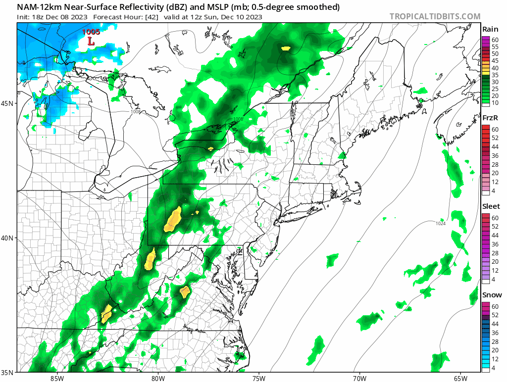
Above: the 12km NAM with its more aggressive depiction of moisture remaining after the front passes Monday morning. For now that's discounted but we do think snow does fall in NW CT leading to a minor accumulation.
Overall
Saturday looks fine and much of Sunday will be ok as well despite showers and rain moving into the state in earnest by afternoon. Be prepared for showers late morning given the shift we've seen to earlier rainfall, but the heaviest rain and wind is overnight Sunday into Monday morning. Rain will be heavy at times.
Winds will be strong, but not terribly out of the ordinary for a strong wintertime system. Scattered power outages are possible.
The storm will depart Monday afternoon leaving breezy conditions and the seesaw back to colder conditions.
Finally, we've gotten a lot of questions about snow prospects for the time around Christmas. It's still too early to have a real sense of the pattern around the holiday, but note that on average we do not see a White Christmas. Give it a week before we're in medium range to look at the Christmas pattern.
As always, please like, share, and interact with us on our social media--on Facebook to share our discussions, and follow us on Twitter @southernctwx to retweet our posts. Hit the buttons below to join.
Thank you for reading SCW.
-DB
