Good morning from Southern Connecticut Weather,
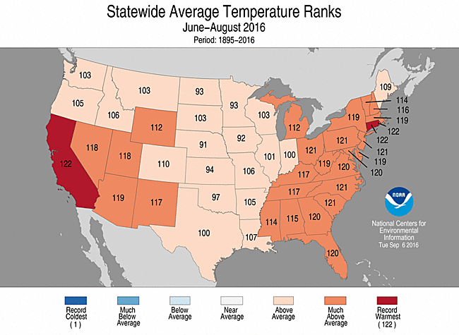
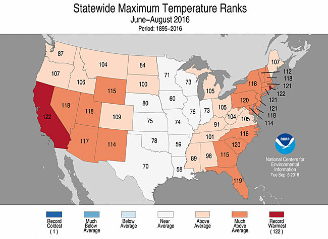
After a ho-hum start to summer, it came back with a vengeance, torching Connecticut from late July through almost half of September. This was officially one of the hottest summers (June-August) on record, which is even more impressive considering how average the first half of summer was.
After a ho-hum start to summer, it came back with a vengeance, torching Connecticut from late July through almost half of September. This was officially one of the hottest summers (June-August) on record, which is even more impressive considering how average the first half of summer was.
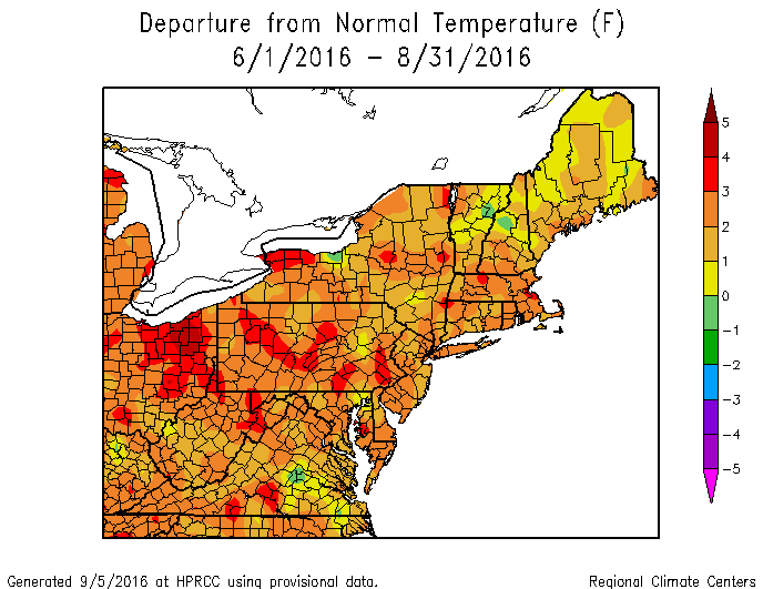
NRCC temperature departures from meteorological summer. Yep, it was a warm one.
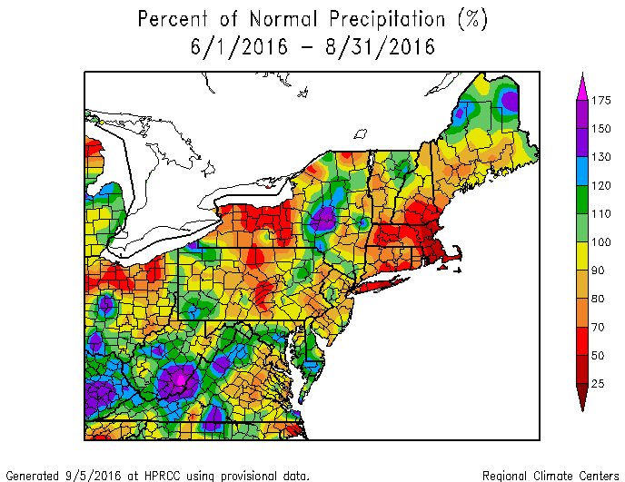
NRCC precipitation departure map. During met summer, much of Connecticut was well below average.
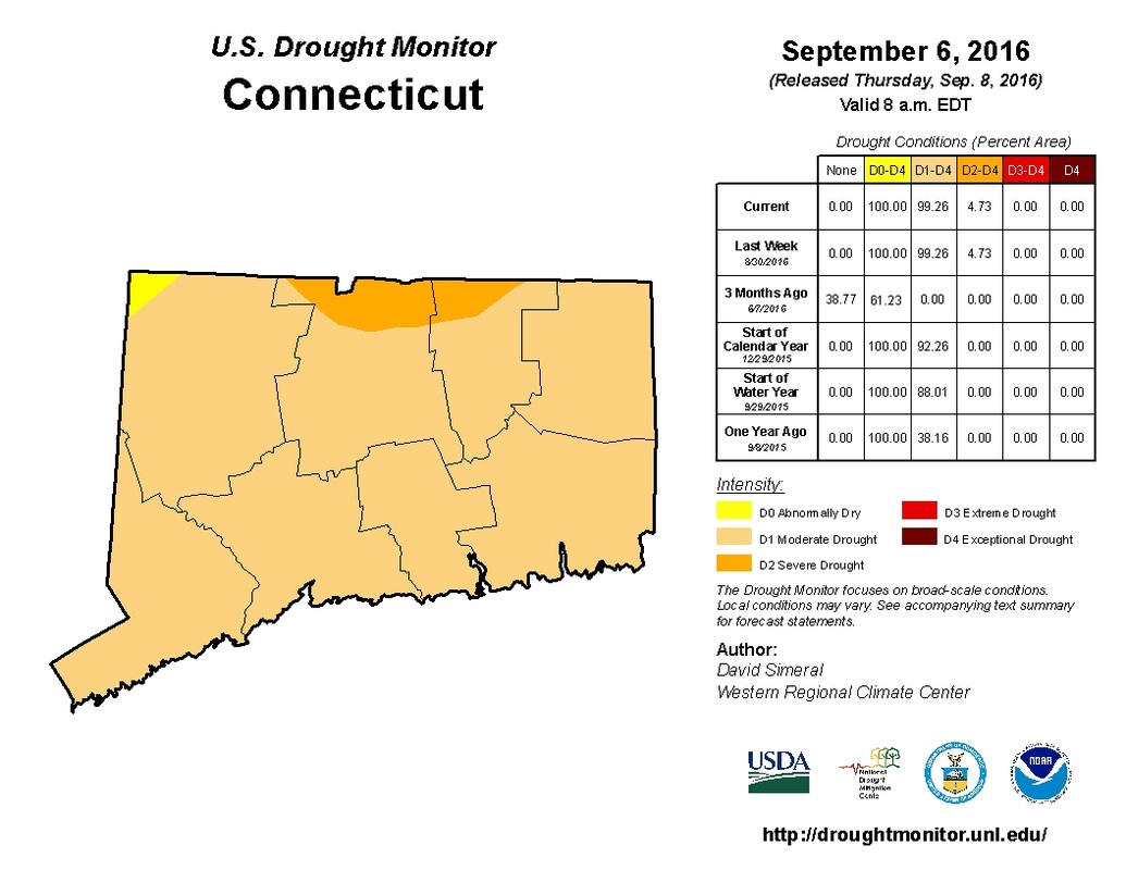
Unfortunately, with the heat came very dry conditions—not quite as bad as Boston, which saw its driest summer on record, but still pretty bad for our region.
Unfortunately, with the heat came very dry conditions—not quite as bad as Boston, which saw its driest summer on record, but still pretty bad for our region.
BDL saw its 30th 90 degree day yesterday. That puts the season in rarified air, with only five other seasons having more 90+ days. To hammer home the point once more, this was a very very hot summer.
But I am proud to report today that our long nightmare is over. After reviewing climatology and the long range pattern, I am ready to declare summer over in Connecticut.
To be clear, that doesn’t mean that we can’t get warmer than normal, or even have a seasonably hot day in there—that is typical during early fall—however, I think the long wave pattern has fundamentally shifted, and with the timing coinciding with our continual step-down in average high temperatures, I do not think we see anymore serious threats of 90 degree temperatures (or upper 80s) this year.
Let’s take a look at what’s normal this time of year.
September Climo
Hartford (BDL)
Sept 11 Average High Temperature—77
Sept 11 Average Low Temperature—55
Sept 30 Average High Temperature—69
Sept 30 Average Low Temperature—47
Bridgeport (BDR)
Sept 11 Average High Temperature—76
Sept 11 Average Low Temperature—60
Sept 30 Average High Temperature—69
Sept 30 Average Low Temperature—53
The persistent southeast and Atlantic ridging that’s allowed us to be plagued by high heat and humidity is starting to come under attack by continental air masses. Over the next two weeks, instead of persistent ridging, I’m expecting to see stronger cold fronts, which will break down the warmer than normal temperatures that will attempt to make appearances as the annual battle between warm and cool begins in earnest.

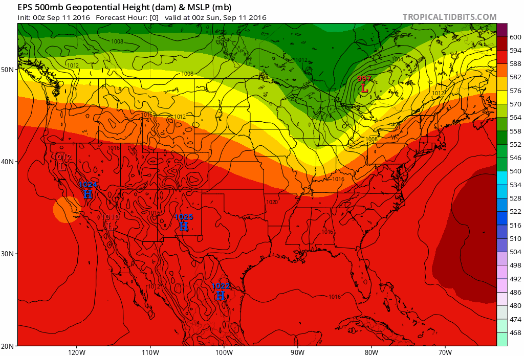
So what do we see here above (GEFS on top/EPS on bottom)? You can see that we have an more fluid shift between warm and cool, which is a marked shift from the last few months. With this shift, extended heat looks to be off the table, thought there could be some warm days.
Sunday
Although storms have been moving through Connecticut early this morning, this is a good thing! In addition to the much needed rain, this heralds the arrival of the cold front that will usher in cooler and drier conditions. We’re warm today with highs in the low to mid 80s, but as the cold front passes today, we clear out and both temps and humidity drops. How do lows in the mid 50s tonight sound?
Monday/Tuesday
Beautiful. We get another taste of fall tomorrow, with highs in the mid to upper 70s and sunny conditions. After a Monday night with lows into the 50s again, Tuesday is warmer as high pressure shifts off shore. Highs are likely to be in the low to mid 80s again, but it won’t last forever.
Wednesday
Wednesday may be the warmest day of the week, as another solid cold front approaches. This is our best chance of rain for the week, though I think we’ll see scattered showers instead of a widespread drink at this point. Highs remain in the low to mid 80s, but we get right back to seasonable fall conditions after the front passes.
Thursday-Saturday
If the front slows down, we could see showers early on Thursday, but right now I think we have a faster passage and Thursday through Saturday are beautiful with highs in the mid to upper 70s and lows in the 50s as high pressure takes over.
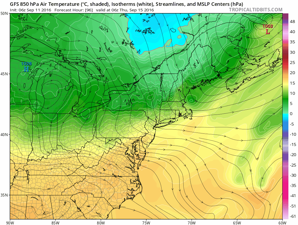
Above is a GFS representation of 850mb temperatures and flow Thursday through Saturday. I see a lot of northwest flow and comfortable temps just above the surface. That should translate to a nice taste of fall!
All in all—a beautiful stretch of weather is coming. There are few rain chances, but one problem at a time—big heat is on its way out. Soon, we’ll be turning to fall foliage!
The dailies:
Sunday: Rain early with gradual clearing during the afternoon. Highs in the low to mid 80s. Chance of rain 30%.
Monday: Sunny. Highs in the mid to upper 70s. Lows in the upper 40s in the cold spots to mid 50s in urban areas.
Tuesday: Sunny and warmer. Highs in the low to mid 80s.
Wednesday: Increasing clouds with a chance of showers in the afternoon and evening. Highs in the low to mid 80s. Chance of rain 60%.
Thursday: Sunny and comfortable. Highs in the mid 70s with lows in the upper 40s to low 50s.
Friday: Sunny. Highs in the mid to upper 70s.
Saturday: Sunny. Highs in the upper 70s.
Finally, I want to say two more things. First, we've heard some ask when we begin to turn to winter. Although we're watching the overall hemispheric trends (ENSO and the like), it's still a bit early to do an outlook anyone can have confidence in. We should have our winter outlook out by early November.
Second and more important, today is not just another day. On this September 11th we are reminded of all Americans who selflessly run toward danger at home and defend our way of life abroad. SCW would like to extend our thoughts and appreciation to all of our first responders, servicemembers and veterans. Thank you for all that you do and have done for us.
-DB
