Good afternoon from Southern Connecticut Weather
It’s the end of October, and the forecast for the week ahead isn’t terribly exciting (or difficult), so I want to depart from the typical format today.
It’s the end of October, and the forecast for the week ahead isn’t terribly exciting (or difficult), so I want to depart from the typical format today.
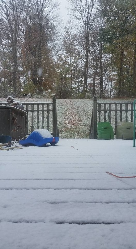
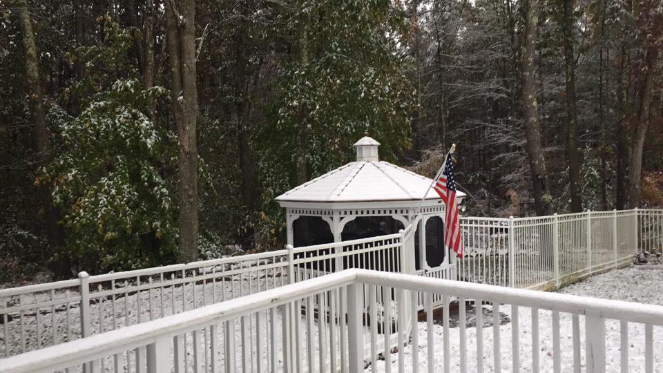
Snow! Much of interior Connecticut saw its first measurable snow event on October 27th. Thanks to Carole K (above) and Sean M (below) for sharing their photos!
We’re deep into fall now, much of the region is past peak with foliage, and after I personally saw snowflakes in Upstate New York last Saturday, and most saw snowflakes in Connecticut earlier this week, the desire for winter to get here already has undoubtably been ratcheted up for some. A word of caution however. It’s still fall. Although it can be more wintry than preceding months, November isn’t terribly wintry in the whole scheme of things usually. November is a transition month in Connecticut, and I expect it to be no different this year.
In weather, we often use the term “step-down” to describe the transition from one season to another. Late fall is a time where you can see the battle between two seasons become an all out war. You can have wild variations between hot and cold, a more muted battle that brings periods of warm and cool, or one season dominate the landscape.
This November, I don’t see either dominating, at least in the first half of the month. I think that overall, we’re looking at a typical gradual step-down toward winter in Connecticut, with short and frequent oscillations between warm and cool early in the month, a transitional period that leans more directly toward below normal temperatures in the middle, and a more deliberate move toward colder than normal conditions in the last week to ten days of the month. I think that the long range ensembles, which are currently hinting at a push toward colder conditions by the middle of the month, may end up being a bit too fast with a quick change to consistent winter-like conditions.
November Normals
The best way to set expectations and illustrate what a typical November means in Connecticut is to present the data:
The average November snowfall in Hartford is 2.0”.
The record November (monthly) snowfall in Hartford is 15.6” in 1938.
The average November snowfall in Bridgeport is 0.7”.
The record November (monthly) snowfall in Bridgeport is 8.4” in 2012.
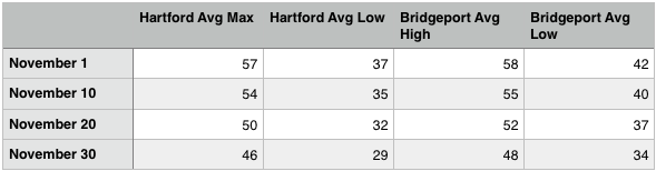
So what do we see with the data? The step-down really begins to steepen after the first third of the month. If you dive deeper into the data, that’s when we’re most likely to see minor measurable snowfall events, if at all. A well timed event is certainly possible, especially for interior locations where temperatures at or below freezing become typical by the last third of the month, but those are impossible to forecast this far out.
One other thing that needs to be mentioned—even with our first minor winter weather event in the books, an October snow event itself does not portend a cold and snowy winter. The pattern in October is the pattern in October, and we usually get a better sense of what early winter can bring with looking at the hemispheric pattern and ENSO (El Nino/La Nina/Neutral state) in early to mid November. We’re just now getting in the range of acceptability with regard to looking ahead to winter. That said, we’re currently working on our winter forecast, and we expect it to be ready in the next week or two. Stay tuned!
One other thing that needs to be mentioned—even with our first minor winter weather event in the books, an October snow event itself does not portend a cold and snowy winter. The pattern in October is the pattern in October, and we usually get a better sense of what early winter can bring with looking at the hemispheric pattern and ENSO (El Nino/La Nina/Neutral state) in early to mid November. We’re just now getting in the range of acceptability with regard to looking ahead to winter. That said, we’re currently working on our winter forecast, and we expect it to be ready in the next week or two. Stay tuned!
Your Week Ahead
As I said at the start of the discussion—nothing terribly exciting this week. Today, we see another chance of rain (as an aside, I’ve been heartened by the uptick in rain events the last few weeks), followed by a period of below normal temperatures Monday and Tuesday, followed by a big warmth push Wednesday-Thursday with another rain chance, followed by a cool weekend.
As I said at the start of the discussion—nothing terribly exciting this week. Today, we see another chance of rain (as an aside, I’ve been heartened by the uptick in rain events the last few weeks), followed by a period of below normal temperatures Monday and Tuesday, followed by a big warmth push Wednesday-Thursday with another rain chance, followed by a cool weekend.
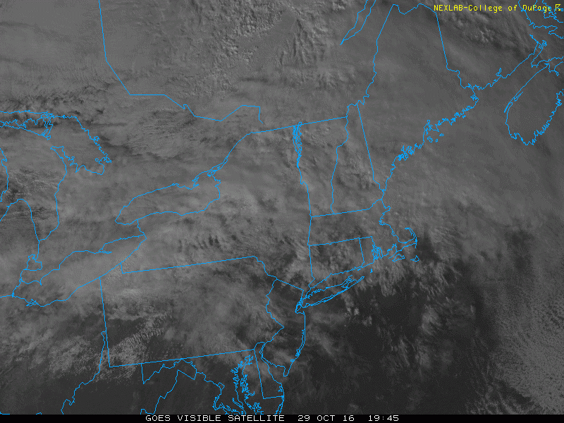
Recent visible satellite image of New England. Note the area of cloudiness and disturbed weather out west. That's our rainmaker today.
Today has started out nice, but our chance of rain begins in just a few hours as an area of low pressure advances from the west and slides to our south this afternoon and tonight. I expect rain to begin overspreading the state between 3-7pm, with heavier rain possible during the early evening hours. Rain should exit the state entirely shortly after midnight. It doesn’t look to be a big rain event, but we’ll take every drop we can get.
Today has started out nice, but our chance of rain begins in just a few hours as an area of low pressure advances from the west and slides to our south this afternoon and tonight. I expect rain to begin overspreading the state between 3-7pm, with heavier rain possible during the early evening hours. Rain should exit the state entirely shortly after midnight. It doesn’t look to be a big rain event, but we’ll take every drop we can get.
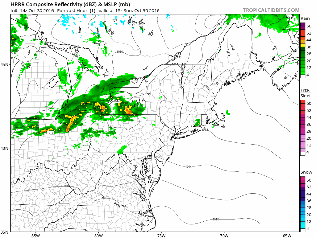
Short range model depiction of the coming rain event. It’s an umbrella afternoon and evening for sure.
Monday/Tuesday
Monday and Tuesday look to be colder than normal days, as high pressure approaches from the west and brings cooler and drier air. We’re not talking about temperatures as cold as earlier this week—when many locations didn’t reach 40(!) but upper 40s to low 50s at the shore is still a bit chilly for this time of year—especially in a regime that has been warmer than normal overall the last few months. If you’re trick or treating Monday night, bundle up the kids! I expect the temperatures to drop fairly quickly with high pressure bringing ideal radiational cooling conditions.
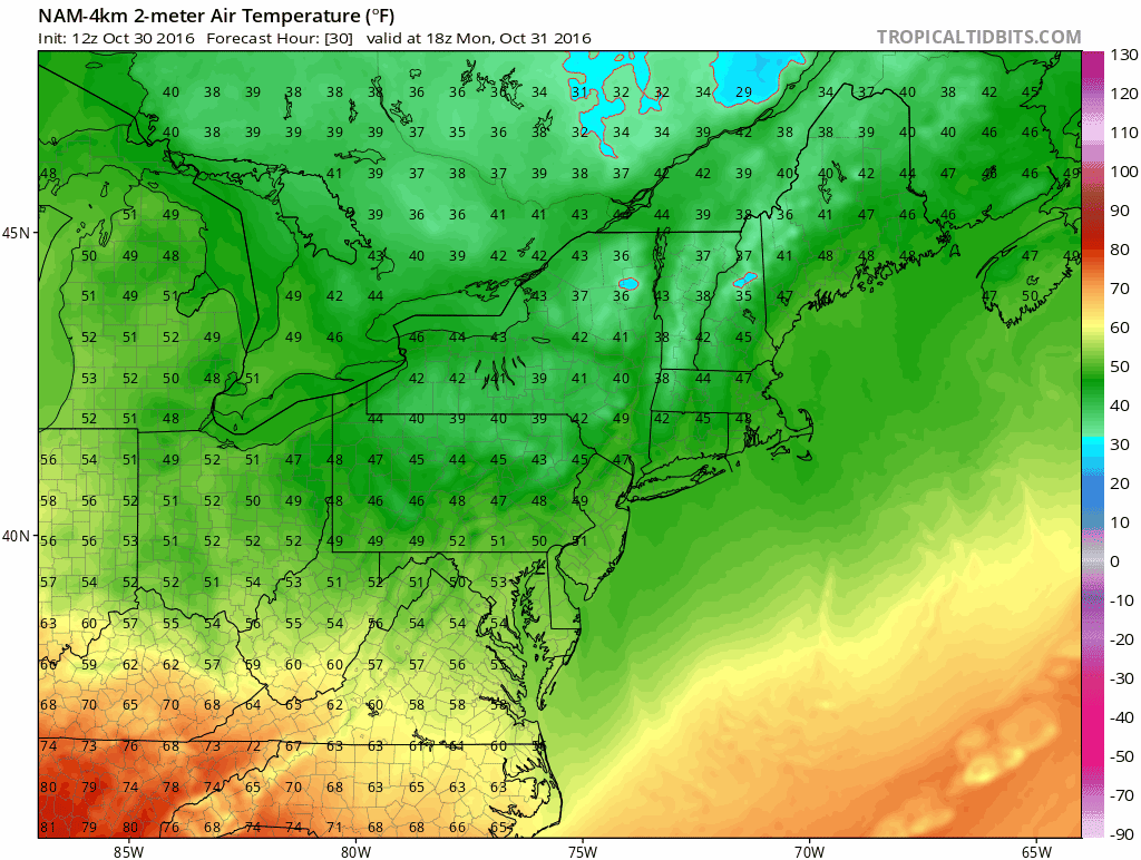
I don’t often do this, but above are the high resolution NAM temperatures from 2pm to 11pm on Monday. Temps may be in the 30s, especially in inland areas by 11pm. Tuesday looks a touch warmer but still (slightly) below normal.
Wednesday/Thursday
By Wednesday, the “heat” is on again, as the area of high pressure brings more of a westerly flow. Wednesday looks to be above normal, but Thursday looks to bring the biggest departure from normal, perhaps with temperatures in the 70s in spots? That’s impressive for early November. As a cold front approaches on Thursday, we see another chance for showers.

Euro depiction of 850mb temperatures and flow over the course of the week. I post less for the temperatures aloft and more to illustrate the overall seesaw pattern during the week. By the weekend, we’re looking at a return to cooler conditions.
Friday/Saturday
With the front through our region, it looks like we’re back to normal to slightly below normal temperatures with dry conditions. However, I’m a touch intrigued by the GFS, which has hinted at a possible clipper type system diving down from Canada in the Saturday timeframe. With cold air around, it’s something to watch to see if we can squeeze out another minor rain or mixed precipitation event. We shall see…
The dailies:
Sunday: Sunny early with increasing clouds and rain by mid-late afternoon. Rain may be heavy at times. Highs in the upper 60s to low 70s. Chance of rain 100%.
Monday: Rain ending shortly after midnight. Sunny and much cooler. Highs in the mid to upper 40s inland with highs in the low 50s near the shore. Nighttime lows in the low to mid 30s.
Tuesday: Sunny and dry. Highs in the mid to upper 50s.
Wednesday: Sunny and warmer. Highs in the low to mid 60s.
Thursday: Increasing clouds with a chance of rain by late in the day. Highs in the upper 60s to low 70s. Chance of rain 50%.
Friday: Sunny and colder. Highs in the low to mid 50s.
Saturday: Increasing clouds with a slight chance of rain or snow showers. Highs in the low to mid 40s. Chance of precipitation 10%.
Thanks for reading! Be sure to like us on Facebook and follow us on Twitter @SouthernCTWX. Have a great week and Happy Halloween!
-DB
