Good afternoon from Southern Connecticut Weather!
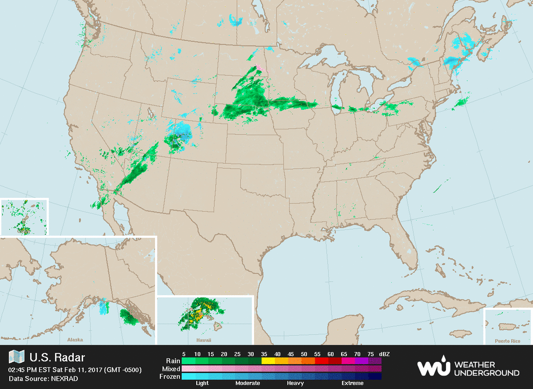
Well, we've made it through 2 of 3 short term winter events. A general coating to 2 inches fell across the great state of Connecticut from late last night through early this morning. Some on the shoreline are saying, "What snow?" but as is standard operating procedure with "clipper" systems, the bulk of the snow trended north. For the rest of today we’re looking at a brief break in the overcast in most places before clouds filter back in later this evening. Temperatures around the state will range from the mid to upper 30s inland, with low to mid 40s at the shore. As we head through this evening temps will drop back into the low 30s at the shore and mid 20s inland. Clouds should begin to filter back in later this evening, toward midnight, with some snow filtering into the state by dawn, and then the forecast gets a bit tricky.
Well, we've made it through 2 of 3 short term winter events. A general coating to 2 inches fell across the great state of Connecticut from late last night through early this morning. Some on the shoreline are saying, "What snow?" but as is standard operating procedure with "clipper" systems, the bulk of the snow trended north. For the rest of today we’re looking at a brief break in the overcast in most places before clouds filter back in later this evening. Temperatures around the state will range from the mid to upper 30s inland, with low to mid 40s at the shore. As we head through this evening temps will drop back into the low 30s at the shore and mid 20s inland. Clouds should begin to filter back in later this evening, toward midnight, with some snow filtering into the state by dawn, and then the forecast gets a bit tricky.
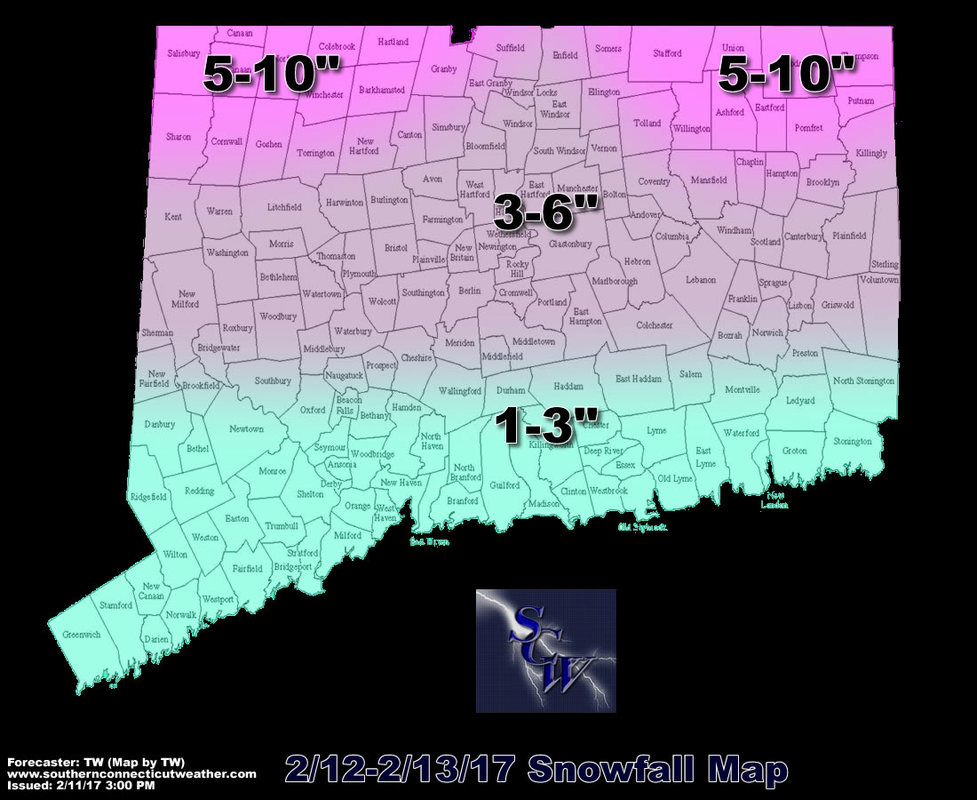
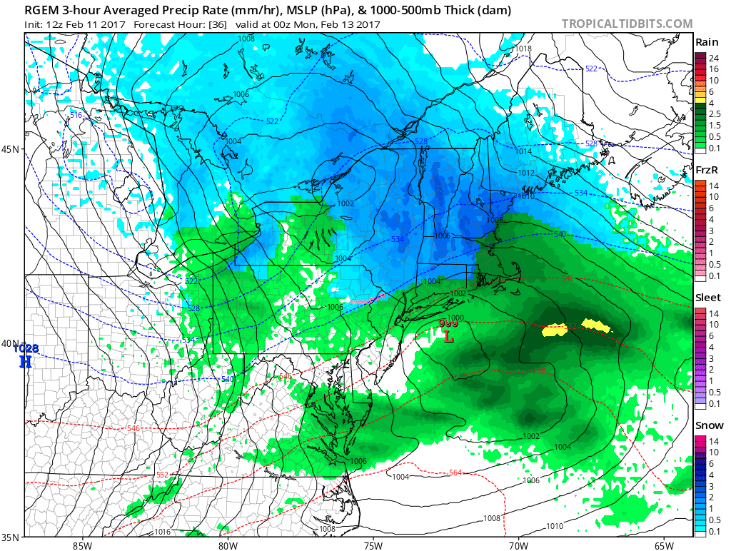
Between early Sunday morning and early Monday morning, the state will be impacted, yet again, by an area of disturbed weather which will bring frozen precipitation to all corners of the state. In most spots this doesn't look to produce as much as the storm system on Thursday, but will still provide more of the white stuff to Connecticut. The type of storm we are dealing with is called an "SWFE" or southwest flow event. In Connecticut, these don't usually provide much in the way of snow outside of elevated areas, especially in the northeast hills, but for this system it looks as though the Litchfield hills will get into action as well. Thus dual "Jackpot" zones are illustrated on the map.
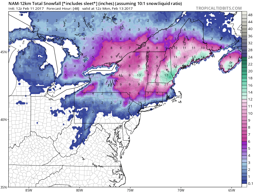
On the models we have a bit of battle with the GFS standing on its own on the warm side, making things in Connecticut more wet than white. While other models such as the GGEM, NAM, RGEM, and Euro more on the cold side bringing 8-12 inches to much of northern Connecticut, especially the hills in both the eastern and western portions of the state. The GFS is the warm outlier and I will basically toss it due to my thinking that the temperature profile is wrong, while the Euro is the colder and snowier model, which I will take more with a grain of salt in the thinking that it is overdoing QPF.
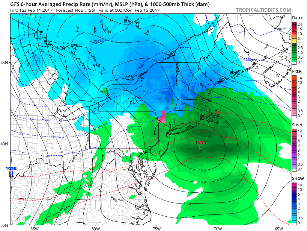 | 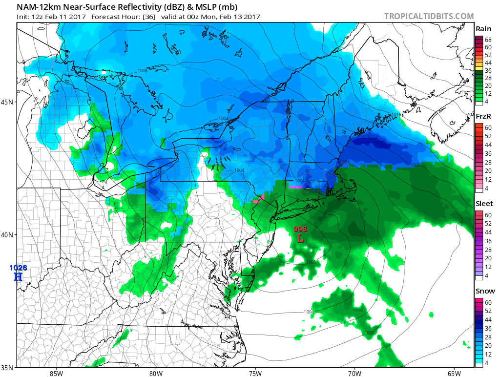 |  |
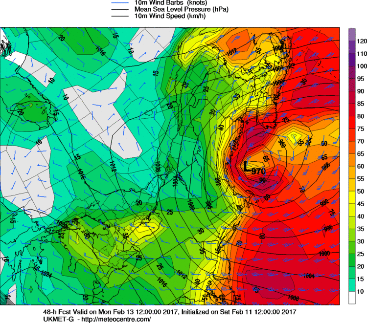
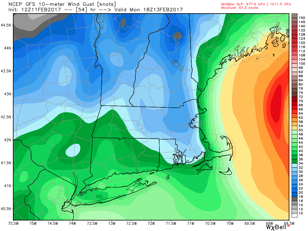
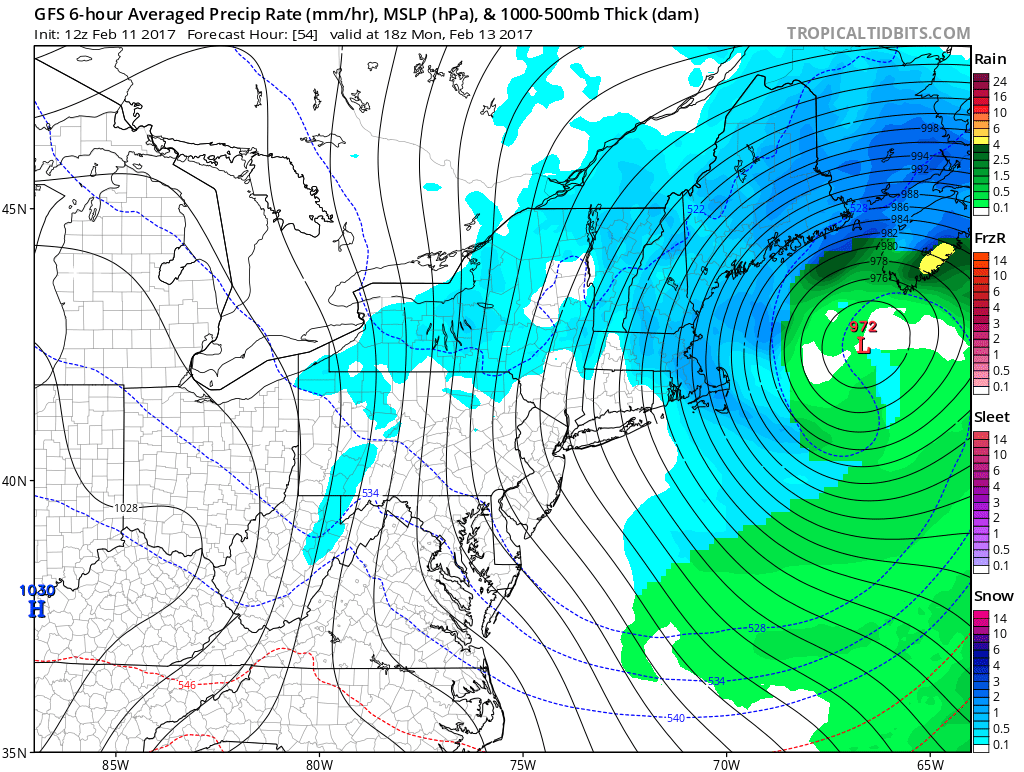
As far as temperatures and winds, uniformly models are really keying in on gusty winds ranging from blowing out of the east and northeast during the day on Sunday, to very gusty winds on the backside of the storm from out of the northwest promoting cooling. From everything I've seen, I'd expect wind gusts to approach 30 mph during the day on Sunday with winds ramping up later Sunday night and continuing through most of Monday. With these east winds and a storm system approaching from the south and west, temps will gradually rise at all levels of the atmosphere we head through Sunday. Inland locations will stay between 30 and 33 degrees at the surface, with temps on the shore rising into the mid to upper 30s, thus promoting a more rainy solution in these locations. At this time the difference between 8 inches and a foot of snow in the northeast and northwest hills is temperatures and snow to liquid ratios. Right now I'm thinking around 8 to 1 snow to liquid ratios at the shore, with 10 to 1 ratios inland, any slight fluctuations down in temperatures at the mid levels could mean ratios inland could be as high as 15 to 1, but generally I'm thinking in the aforementioned ratios of 10 to 1.
 |  |
What all the models do show is a drop off in snow as you head toward the Connecticut River Valley, as is the case with most storms. Being in an area with a lack of elevation near a body of water really does not help, especially with this storm, so you may see 8-10 inches of snow in a place like Suffield or East Granby but head east toward the Connecticut River a few miles and have 4-6 inches. All a function of downsloping winds, which promotes warmer temps and drier conditions, many of you in the valley know all about "screw zones" due to this feature.
As we navigate down the map, you will see a familiar sight for those who have lived on the shore for a while, the least amount of snow is expected to fall there, and most of that 1-3 inches will fall with the warm air advection snows on Sunday morning. Basically, this will be a storm where the low pressure area is too close to the coast for sub-freezing temps to stay in place. As shortwave system moves in, winds will gradually turn from being out of the north, to being out of the northeast, and finally out of the east, promoting warming of all levels of the atmosphere from the 500 level all the way to the surface, but before that, there is some cold air to be displaced, thus accumulating WAA snows to start the event in southern Connecticut. I think all places outside of the northeast and northwest hills change to a period of rain. During the evening on Sunday, and when the storm has really wound up well to the east of us, winds will really pick up and will begin to swing more out of the west and northwest, promoting cooling, therefore I expect any places that have changed to rain to change back to a quick burst of snow and sleet with minimal extra accumulations. Gradual clearing is expected by very early Monday, but strong, gusty northwest winds stick with us during the day on Monday making for a blustery and cold day. Wind gusts could approach 50 mph.
To recap...
- Clouds thicken late Saturday night, snow moves into the state by early Sunday morning
- 1-3 inches of snow at the shore before changing to rain late Sunday morning/ Early Sunday afternoon
- 3-6 inches of snow in central CT and northern CT outside of the hills before a change to rain Sunday PM
- 5-10 inches in the northeast and northwest hills, expected to be mostly snow, some sleet and rain could mix in Sunday PM
-Everyone is expected to change back to snow later on Sunday night, with the chance for an extra inch or 2 of accumulation before precipitation tapers off early on Monday
- Gusty winds will become an issue as we head through the day on Sunday, and especially so during the day on Monday when winds could gust up to and over 45 mph
Thank you for taking your time to read our storm discussion, we really appreciate it! Have a great rest of your day and feel free to ask questions on our Facebook and Twitter pages. Stay tuned for all the latest as we keep you informed, before, during and after the storm.- TW
