We're finally in a pattern that can be characterized as fairly typical for the time of year. There is one caveat, however, and that is storminess. The one constant in the pattern, whether it has been hot or cold, has been the barrage of storms and heavy precipitation events to hit the area, and that theme looks to continue.
Currently: Not much is happening across the Northeastern United States today. The current weather maker is high pressure centered over the Great Lakes region.
Tonight: Although this isn't really radiational cooling season, with high pressure moving overhead and calming winds, we'll have as ideal a setup as you really can get this time of year for radiational cooling. Therefore, I'll go a couple degrees cooler than all guidance. Temperatures throughout the state should be somewhere in the 40s, with a few 30s not even out of the question in sheltered valleys and the NW hills.
Tomorrow: The only big question is whether or not high cirrus begins to spill over late in the day. Other than that, another beautiful day is expected. Guidance is in reasonable agreement, and I see no reason to disagree with consensus. High temperatures should approach 70, with cooler locations probably coming up just short.
Tomorrow Night/Wednesday: A cold front will approach on Wednesday, with our next precipitation threat. At this point in time, we're not sure where the axis of heaviest rain will set up, which is typical at this time. There are two bright spots at this time: First, it appears the threat for severe weather will be limited to areas south of the area. Secondly, it appears that most, if not all of the precipitation will be limited to nighttime. So, we can keep Wednesday dry during the day. As is also typical in these setups, temperatures could be a bit tricky. However, guidance is fairly tightly clustered, so that does increase confidence in temperatures. Right now, the general thinking is upper 70s for high. But if a bit more sun is realized than currently forecast, a few places could touch 80.
Long Term: Thursday and beyond- The long term highlights are two thunderstorm threats- the first on Thursday and the second on Sunday, with nice weather in between.
For Thursday, this could be a better chance of severe weather for the area. A cold front will approach from the west. The area will fully be in the warm sector. If the pre-frontal thunderstorms can be timed coincident with daytime heating, it will be the near perfect setup for severe weather in this area. Obviously, this is still three days out, so nothing is set in stone yet. As for temperatures, I don't see any glaring reason to go against guidance, which is tightly clustered. So expect highs within a few degrees of 80.
Fri-Sun: The heat ridge will be pumping, so I have decided to go a bit above guidance these three days. The next frontal system does not arrive until Sunday night into Monday, so for now, I'll leave the day period on Sunday dry. With fair conditions, expect highs of 80 to 85 Friday and Saturday and mid 80s on Sunday. By Sunday, humidity levels will increase.
The next frontal system arrives Sunday night into Monday, and it may actually be a battle between two frontal systems- a "traditional" cold front approaching from the west, and a backdoor cold front dropping down from the north. At this time, it is obviously way too early to try to time each front and determine the effects of each frontal system on the area. Suffice it to say, it should be unsettled with cooler temperatures.
Aside from the usual run-to-run variations that you'd expect to see in the long range, most of the long range looks to see a continuation of the current pattern, especially with regards to frequent precipitation events.
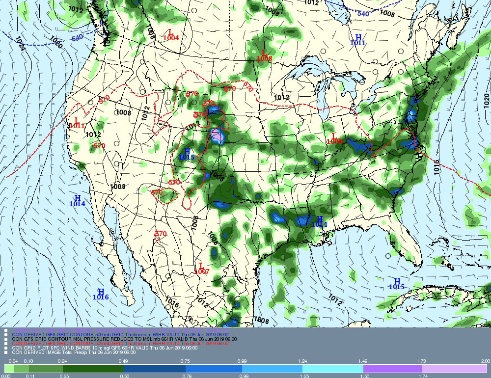
Now, let's take a look at Wednesday and Thursday graphically, and treat them as individual threats, since, in a sense, they are. As I mentioned, Wednesday appears to be more of a heavy rain threat than anything else, and look at all the heavy rain up and down I 95 poised to move into CT!
Currently: Not much is happening across the Northeastern United States today. The current weather maker is high pressure centered over the Great Lakes region.
Tonight: Although this isn't really radiational cooling season, with high pressure moving overhead and calming winds, we'll have as ideal a setup as you really can get this time of year for radiational cooling. Therefore, I'll go a couple degrees cooler than all guidance. Temperatures throughout the state should be somewhere in the 40s, with a few 30s not even out of the question in sheltered valleys and the NW hills.
Tomorrow: The only big question is whether or not high cirrus begins to spill over late in the day. Other than that, another beautiful day is expected. Guidance is in reasonable agreement, and I see no reason to disagree with consensus. High temperatures should approach 70, with cooler locations probably coming up just short.
Tomorrow Night/Wednesday: A cold front will approach on Wednesday, with our next precipitation threat. At this point in time, we're not sure where the axis of heaviest rain will set up, which is typical at this time. There are two bright spots at this time: First, it appears the threat for severe weather will be limited to areas south of the area. Secondly, it appears that most, if not all of the precipitation will be limited to nighttime. So, we can keep Wednesday dry during the day. As is also typical in these setups, temperatures could be a bit tricky. However, guidance is fairly tightly clustered, so that does increase confidence in temperatures. Right now, the general thinking is upper 70s for high. But if a bit more sun is realized than currently forecast, a few places could touch 80.
Long Term: Thursday and beyond- The long term highlights are two thunderstorm threats- the first on Thursday and the second on Sunday, with nice weather in between.
For Thursday, this could be a better chance of severe weather for the area. A cold front will approach from the west. The area will fully be in the warm sector. If the pre-frontal thunderstorms can be timed coincident with daytime heating, it will be the near perfect setup for severe weather in this area. Obviously, this is still three days out, so nothing is set in stone yet. As for temperatures, I don't see any glaring reason to go against guidance, which is tightly clustered. So expect highs within a few degrees of 80.
Fri-Sun: The heat ridge will be pumping, so I have decided to go a bit above guidance these three days. The next frontal system does not arrive until Sunday night into Monday, so for now, I'll leave the day period on Sunday dry. With fair conditions, expect highs of 80 to 85 Friday and Saturday and mid 80s on Sunday. By Sunday, humidity levels will increase.
The next frontal system arrives Sunday night into Monday, and it may actually be a battle between two frontal systems- a "traditional" cold front approaching from the west, and a backdoor cold front dropping down from the north. At this time, it is obviously way too early to try to time each front and determine the effects of each frontal system on the area. Suffice it to say, it should be unsettled with cooler temperatures.
Aside from the usual run-to-run variations that you'd expect to see in the long range, most of the long range looks to see a continuation of the current pattern, especially with regards to frequent precipitation events.
Now, let's take a look at Wednesday and Thursday graphically, and treat them as individual threats, since, in a sense, they are. As I mentioned, Wednesday appears to be more of a heavy rain threat than anything else, and look at all the heavy rain up and down I 95 poised to move into CT!
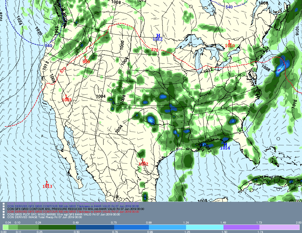
Now, Thursday, I believe is more of a severe weather threat. The image posted below depicts thunderstorms across much of New England.
That's all for now, see you next time!
-GP!
-GP!
