A quick venting session:
In the close to ten years that I’ve been forecasting, I can’t remember a winter that has had as many variations in the modeling as this one. In most winters, the forecast progression goes something like this:
The question that you’re probably asking yourself is: Why? Unfortunately, I don’t know the answer. I can take a guess or two(Which will be the subject of a later piece), but there’s no concrete explanation for it. Regardless, we have to work with the cards that we’re dealt, and as such, we go into another event with little idea of what is actually going to happen.
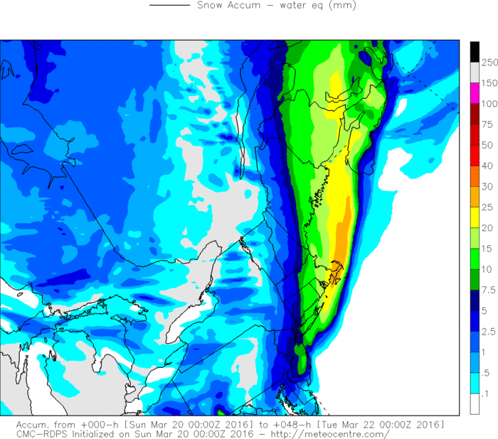
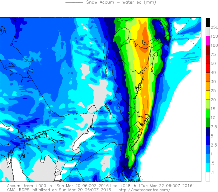
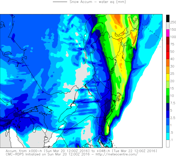
Continuing what Don showed us last night, here’s the next 3 runs of the RGEM(I can’t continue to show the GFS as it hasn’t run yet at 12z due to technical difficulties): 0z, 6z, and 12z. This sort of discontinuity is what you’d usually expect to see at 3-4 days before a storm develops, not a few hours, and that’s been the pattern all winter.
In the close to ten years that I’ve been forecasting, I can’t remember a winter that has had as many variations in the modeling as this one. In most winters, the forecast progression goes something like this:
- 5-7 days out: Identify a storm chance
- 3-5 days out: Confirm the reality of the system; start narrowing the goalposts as to where it will form and impacts.
- 72-48 hours: Last chance for significant shifts, if models remain consistent, begin discussing preliminary accumulations
- 48-24 hours: First call maps, subtle shifts in temperature or placement, last few details are worked out.
- 24-0 hours: Final call maps, minor trends towards stronger/weaker systems, verification.
- 5-7 days out: Identify a storm chance.
- 3-5 days out: Build an excellent consensus for either a big hit or a miss, only to have it promptly swing back the other direction.
- 72-48 hours out: Models agree on a miss, and forecasters begin to downplay the event.
- 48-36 hours out: A strong northwest trend happens and the storm comes back.
- 36-24 hours out: We’re almost back to the original idea from 5 days out.
- 24-12 hours out: The storm goes southeast, then northwest again, then back southeast, and now looks like a much more insignificant event.
- 12-0 hours out: Model discontinuity continues to be all over the map, verification occurs and an unmodeled band forms somewhere and jackpots a portion of the state that no one was expecting.
- Constantly: A general sense of chaos, uncertainty, and diminished confidence, leading to this forecaster pulling his hair out.
The question that you’re probably asking yourself is: Why? Unfortunately, I don’t know the answer. I can take a guess or two(Which will be the subject of a later piece), but there’s no concrete explanation for it. Regardless, we have to work with the cards that we’re dealt, and as such, we go into another event with little idea of what is actually going to happen.
Continuing what Don showed us last night, here’s the next 3 runs of the RGEM(I can’t continue to show the GFS as it hasn’t run yet at 12z due to technical difficulties): 0z, 6z, and 12z. This sort of discontinuity is what you’d usually expect to see at 3-4 days before a storm develops, not a few hours, and that’s been the pattern all winter.

What we do know:
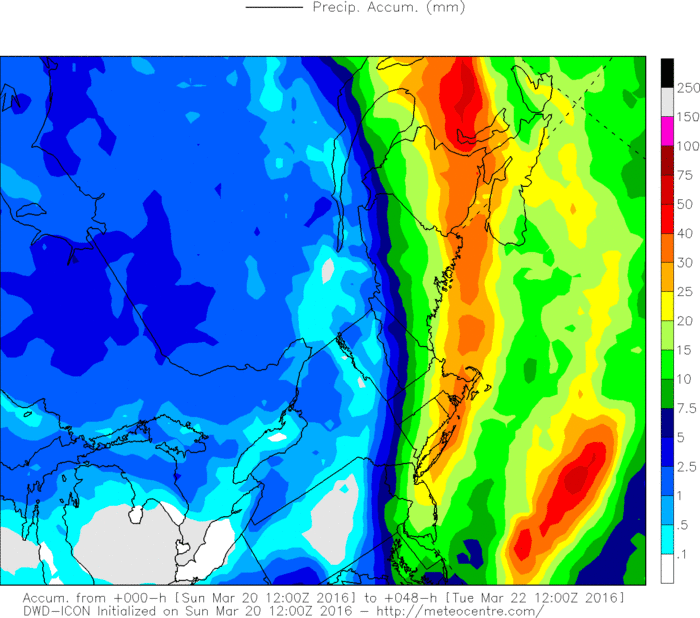
Here’s total precipitation on the ICON(Most bullish model) and on the RGEM(Least bullish model). The difference, especially in eastern areas where it would mean 3” vs. 10”, is pretty remarkable for the lead time.
- There is still a storm system that is approaching the area, and will pass near the 40/70 benchmark later tonight or early tomorrow morning.
- Some snowfall is expected across the area, with the highest totals in the eastern portion of the state, and the lowest in the northwest corner.
- Timing has been pushed back, with steady snow not reaching the state until after midnight, and lasting into the morning rush tomorrow in eastern areas.
- Generally, the model trend over the 0z and 12z cycles has been deamplification and lessening of the impact, however, some guidance continues to push west with each run.
- The short-range guidance has continued to be bullish with each run.
- Exactly how much snow will fall. 12z guidance has generally cut back on amounts, however, there still remains a wide range of totals, from the SREFS, NAM and ICON showing warning level amounts across most of the state to the GGEM and RGEM showing no more than a couple of inches in eastern areas and little to nothing elsewhere.
- Where any bands may form: With the midlevel frontogenesis that is modeled, it is likely that there will be a surprise band or two of heavier snow that will allow whoever gets under it to jackpot. Modeling can and does give us an idea of where those bands may develop, hence the favoring of the eastern portions of the state, however, one could argue for them to develop just about anywhere in the state.
- What the impact to Monday will look like: With the less intense solutions, impacts to the Monday morning commute as well as school closings and delays will be relatively minor. However, with a solution like the one on the ICON or NAM, we’ll see a significant impact to the commute and widespread school cancellations.
Here’s total precipitation on the ICON(Most bullish model) and on the RGEM(Least bullish model). The difference, especially in eastern areas where it would mean 3” vs. 10”, is pretty remarkable for the lead time.
What we think we know.
A look into my thought process while making the below map("Behind the scenes", so to speak):
A look into my thought process while making the below map("Behind the scenes", so to speak):
- Trends this winter have been for events to look like they are going to miss, then come back west at the last minute and verify a little further NW than model progs.
- Guidance has been all over the map, but the general idea has been east, west, east, west, east... essentially alternating back and forth each model cycle. That suggests take the middle.
- Despite total precipitation being all over the map, midlevels haven’t really changed that much. So small large-scale shifts lead to major shifts in outcome on the ground.
- ICON has lead the way with west shifts on our other two systems like this one, but it’s a total outlier.
- UKMET is east and was other leading model on the previous two systems.
- There’s going to be a band somewhere that modeling doesn’t usually forecast well, probably over eastern areas of the state since it’s been NW of consensus all season and consensus is in the Boston to Providence corridor right now.
- The RAP is very bullish and continues to be. Maybe an initialization error with the 12z data and RAP excludes that since it initializes hourly?
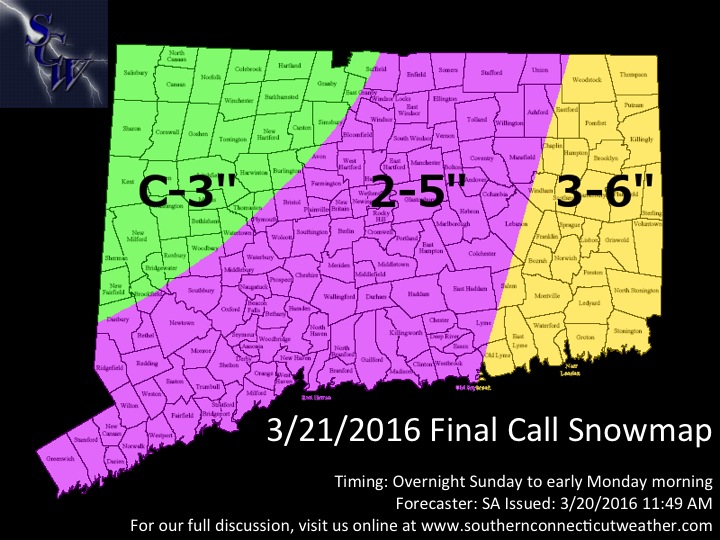
Essentially, we scaled down totals slightly across the state, going from slightly below the guidance consensus to slightly above it. I think that the east trend that we’re seeing now will reverse itself somewhat later today as each previous model cycle has done, and I think that we will see banding develop that will allow for most areas to reach an advisory criteria snowfall, but warning criteria amounts will be limited. The best chance for any 6”+ totals will be in the current 3-6” zone, but I think they will generally be isolated.
Precipitation will start after midnight from south to north, and will taper off west to east throughout the morning commute. I do expect the morning commute to be impacted in eastern areas, especially in the I395 corridor, and also expect some cancellations and/or delays in that area. Further west, some delays are possible, but I think that, as things stand now, cancellations are unlikely.
We’ll keep watching the midday and afternoon guidance, and will be back later tonight on Facebook with some commentary on the trends. Until then, enjoy this final day of winter and thank you for continuing to trust SCW for the very best in Connecticut weather!
-SA
