Good morning to you from SCW!
When this Christmas storm first appeared on the models a few days ago, I was hopeful that it would finally snap our five year streak of Grinch storms on or near Christmas, and until last night, it looked like that would be the case. However, meteorology loves to throw curveballs at us, and quite a bit of the overnight guidance came further west with our low pressure system for Monday, making the net result a rain storm for a lot of the state. Whether this trend is real or not remains to be seen, and there are still two days for it to go back the other way, but if you're a snow lover hoping for a White Christmas, the trend is not your friend in this case. Nonetheless, we will still see some snow across at least part of the state, and so a snowmap and discussion is in order.
Models and Trends
Since yesterday, we've clearly seen a trend towards later development of the secondary coastal low, which means that there is less time for cold air to get wrapped up in the system and the boundary layers warm above freezing as a result. This is shown well by looking at the last couple of NAM runs - you can see the center of the system jump quite a bit NW and the net result go from primarily a snowstorm to primarily a rainstorm.
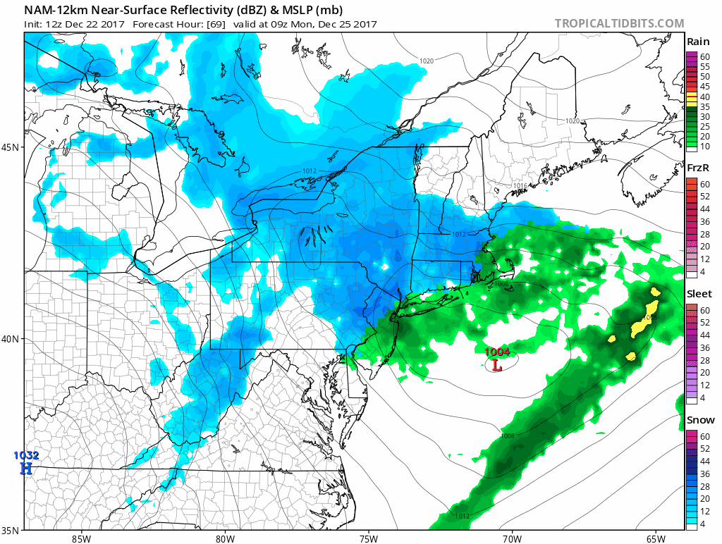
The other issue we're seeing is in the midlevels - the midlevel low pressures have both weakened and shifted NW - that means that we'll see less favorable dynamics and snow growth, so any snow that does fall will more likely be of the lower ratio variety and less likely be of the fluffy dendrite variety. Something to keep in mind when considering snow totals.
While most of the guidance follows the NW trend shown here on the NAM, the Euro is the exception and actually ticked a hair colder last night, which would allow for a mostly snow event across the region. Because of it's earlier development of the coastal, it allows the northeastern portion of our forecast area to get into the band of inverted trough snows that are otherwise forecast to be to our north and actually jackpots that area with 6"+. Unfortunately, that solution is currently an outlier and I am hesitant to give it too much weight considering the trends, but the Euro is a good model with thermal profiles as well as being one of the most reliable pieces of guidance in general, so I feel like I have to give it at least some weight in the forecast. Therefore, will go with a 70/30 blend of the consensus model forecast excluding the Euro at 70% and the Euro at 30%. That blend gives us the snowmap below.
Forecast & Timing
Here is our snow forecast for this event.
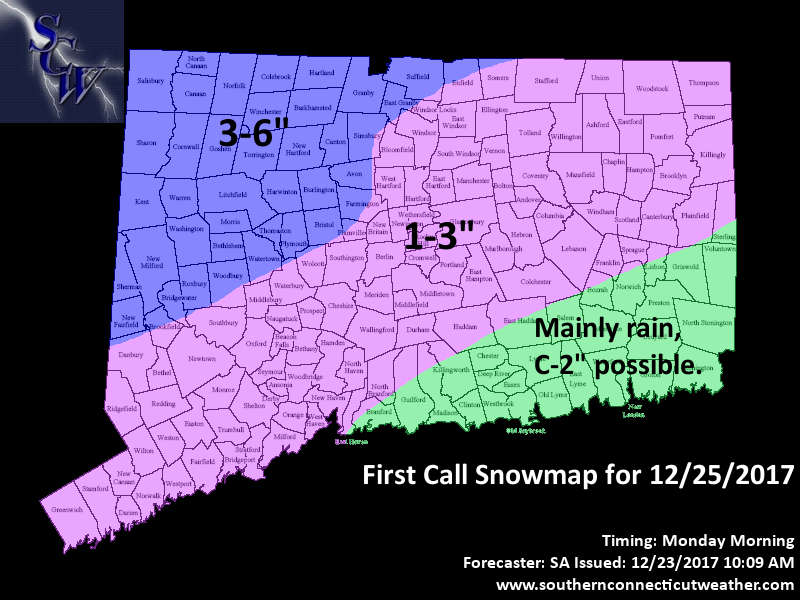
As we discussed last night, the state is split up into three zones for this event, but we moved the zone boundaries a bit NW from what I outlined in that discussion. In the NW portion of the state, mainly Litchfield county and some of the higher terrain in Fairfield and Hartford counties, this should be a mostly snow event. We could see some brief mixing during the height of the system, but a solid 3-6" of snow seems to be a good bet here. In the southeastern corner of the state, I unfortunately am now expecting a mainly rain event. The potential saving grace for a White Christmas there may be a final backside band that comes in as the storm departs - some of the hires models show this band as being strong enough dynamically to flip any rain over to snow and drop a quick coating to an inch or so of accumulation. Will leave a C-2" in the forecast for this zone as a result of that possibility, but wouldn't be surprised to see all rain there.
The rest of the state makes up the battleground zone where this is a tricky forecast. On the Euro, we see mostly if not all snow here, whereas on the rest of the guidance it is a messy rain/snow mix for most of the event or just plain rain, and snow accumulations would likely be minimal at best. I do think that we might see things go a bit colder as we do have some high pressure in play to our north that is often under modeled, and so have gone with a 1-3" forecast here, but that will probably be a messy 1-3". The next couple of model cycles will tell us a lot about the fate of this zone - should we see the warm trend continue, we can probably get rid of this zone and lump this area in with the rain to the southeast, but I'm not ready to go there quite yet. We'll see where the guidance is at tomorrow and if needed we can update then.
As far as timing goes, looks like precipitation comes in after midnight Monday and should be out of the state by 10 AM or so at the latest, even earlier in western areas.
Impacts
Here is the SCW Impact Scale for this event.
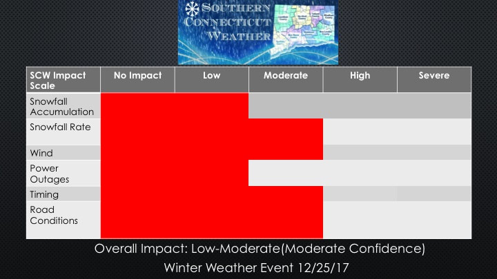
The timing of this event isn't great for those of you heading out for Christmas travel - that final band could sweep in right as folks are getting on the roads. If you're traveling Christmas morning, make sure to keep an eye on the radar and try to leave after 10 AM or so if possible as conditions will be much improved then. Otherwise, looks like a fairly run of the mill event, nothing we haven't seen before or can't handle.
We'll be back tomorrow afternoon with a final update on this system, until then, stay safe out there today with the freezing rain and thank you for reading SCW!
-SA
We'll be back tomorrow afternoon with a final update on this system, until then, stay safe out there today with the freezing rain and thank you for reading SCW!
-SA
