Good evening from SCW!
As Don mentioned on Sunday, we’re tracking a clipper system for tomorrow evening into early Thursday morning that will bring some light snow to the state. In this discussion, we’ll take a closer look at that system and issue a first call snowmap.
Models and Trends
Guidance is in good agreement on swinging an Alberta Clipper system through the state on a nearly due east trajectory. While some runs earlier in the week were showing a more amplified system and possibly some coastal redevelopment, which would have bumped up QPF while also increasing the chance for mixed precip, the past several model cycles have been in good agreement that this will be a weaker and colder event, meaning all snow. There is still some disagreement among the guidance as to how much QPF will be able to work into the region, with the global models (GFS and Euro) supporting an advisory level event across the region while the mesoscale models (NAM/RGEM) are much weaker and only bring an inch or so of snow to the state. There is good agreement between the guidance that areas to the north and east will see the higher amounts, while southern and western areas will see lighter precip as they miss out on any coastal enhancement that does take place as the storm hits open water. I could imagine a solution where Windham County ends up with 3-5” and Fairfield County only a coating to an inch, but think that’s a little too extreme a gradient for right now.
The trend has generally been relatively constant over the past few cycles, with the divide between the globals and the mesos remaining present and relatively constant. While the longer term trend has been to weaken the system, over the last few cycles we’ve seen things stabilize and so I wouldn’t necessarily expect that to continue.
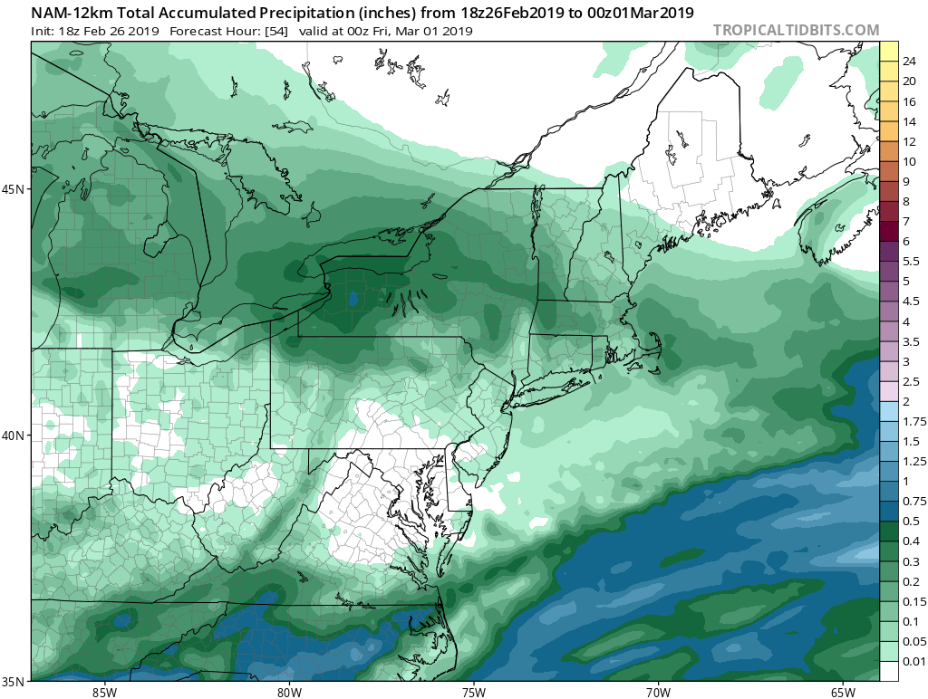
Here’s a look at total QPF from the GFS and the NAM through Thursday evening. The GFS generally advertises a quarter to a third of an inch of liquid across the state, with some isolated spots of up to four tenths of an inch or so. That’s good for 2-4” of snow for most, with far southwest areas being the exception and only seeing an inch or two. Meanwhile, on the NAM, most of the state sees only around a tenth of an inch or so of QPF, with some areas even lower. A coating to an inch would be the result of that solution, if that.
As Don mentioned on Sunday, we’re tracking a clipper system for tomorrow evening into early Thursday morning that will bring some light snow to the state. In this discussion, we’ll take a closer look at that system and issue a first call snowmap.
Models and Trends
Guidance is in good agreement on swinging an Alberta Clipper system through the state on a nearly due east trajectory. While some runs earlier in the week were showing a more amplified system and possibly some coastal redevelopment, which would have bumped up QPF while also increasing the chance for mixed precip, the past several model cycles have been in good agreement that this will be a weaker and colder event, meaning all snow. There is still some disagreement among the guidance as to how much QPF will be able to work into the region, with the global models (GFS and Euro) supporting an advisory level event across the region while the mesoscale models (NAM/RGEM) are much weaker and only bring an inch or so of snow to the state. There is good agreement between the guidance that areas to the north and east will see the higher amounts, while southern and western areas will see lighter precip as they miss out on any coastal enhancement that does take place as the storm hits open water. I could imagine a solution where Windham County ends up with 3-5” and Fairfield County only a coating to an inch, but think that’s a little too extreme a gradient for right now.
The trend has generally been relatively constant over the past few cycles, with the divide between the globals and the mesos remaining present and relatively constant. While the longer term trend has been to weaken the system, over the last few cycles we’ve seen things stabilize and so I wouldn’t necessarily expect that to continue.
Here’s a look at total QPF from the GFS and the NAM through Thursday evening. The GFS generally advertises a quarter to a third of an inch of liquid across the state, with some isolated spots of up to four tenths of an inch or so. That’s good for 2-4” of snow for most, with far southwest areas being the exception and only seeing an inch or two. Meanwhile, on the NAM, most of the state sees only around a tenth of an inch or so of QPF, with some areas even lower. A coating to an inch would be the result of that solution, if that.

Forecast and Timing
Here’s our forecast snowmap for this event.
Here’s our forecast snowmap for this event.
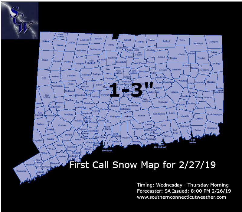
I considered splitting the state in two different ways, the first way being to put a zone of lower totals in the SW corner while leaving everywhere else the same and the second way being to put a zone of higher totals in the NE corner while leaving everywhere else the same. However, given that we still have somewhat of a disagreement between the mesoscale models and the global models, and the magnitude of that disagreement is larger than the likely differences from one corner to another under the same solution, I decided to just stick with a broad brushed 1-3” for now, with the caveat that we’ll likely split that up into two zones tomorrow once we have a better understanding of which solution is going to win out.
As far as timing goes, generally expecting precip to hold off until after dark tomorrow (Wednesday) evening, although it wouldn’t surprise me to see some light snow towards the tail end of the evening commute, especially in western and southern areas. Similarly, I expect snow to be mostly out of the state by the start of the morning commute on Thursday, but could see some residual snow showers linger throughout the morning.
Impacts
Overall expecting a relatively low impact event. Here are the details:
Winter Weather Advisories are in effect from the NWS for the entire state excluding the immediate shoreline.
We’ll be back tomorrow with an updated map, until then, enjoy the rest of your evening and thank you for reading SCW!
-SA
As far as timing goes, generally expecting precip to hold off until after dark tomorrow (Wednesday) evening, although it wouldn’t surprise me to see some light snow towards the tail end of the evening commute, especially in western and southern areas. Similarly, I expect snow to be mostly out of the state by the start of the morning commute on Thursday, but could see some residual snow showers linger throughout the morning.
Impacts
Overall expecting a relatively low impact event. Here are the details:
- Snow Accumulation: Low to Moderate
- Snowfall Rates: Low to Moderate
- Wind: Low
- Power Outages: Low
- Timing: Low to Moderate
- Road Conditions: Low to Moderate
Winter Weather Advisories are in effect from the NWS for the entire state excluding the immediate shoreline.
We’ll be back tomorrow with an updated map, until then, enjoy the rest of your evening and thank you for reading SCW!
-SA
