Good evening from Southern Connecticut Weather.
The storm we've been tracking for the last few days continues to shift around a bit on the guidance, but it's time to issue our first call. Computer guidance is only a tool. At the end of the day, we have to look at the guidance in its totality, but we also have to analyze the overall pattern and environment to make a reasonable call for what's going to happen.
We have enough confidence to issue our first call map, and as you will see in the detailed discussion, there's still a fair amount to sort out. For the first time in 10 weeks, let's analyze a snowstorm.
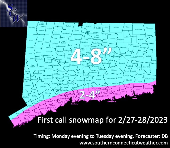
Above: our first call snow map. We expect interior CT to see between 4-8" late Monday into Tuesday. As it stands, we expect most to be in the 4-6" range with the highest potential for more snow in western CT. For coastal CT, we have introduced a 2-4" zone. However, this is a lower confidence zone. We expect most in this zone to end up with 3-4" if you are away from the immediate shoreline.
General Overview
As I said before, we're looking at our first legitimate wintry event in a while because the pattern has changed. Essentially, we are looking at the big storm in California. As it crosses the Rocky Mountains, it will de-amplify, or weaken, as it reaches the Great Lakes. A week or two ago, this would have cut to our west and brought us rain and warmth.
However, because there is a -NAO providing blocking in the Atlantic, rather than a straight cut to our west we will see just enough high pressure to our north as energy transfers, and we see a low develop along the coast, bringing in colder air throughout the column for snow.
While the guidance has bounced around, it has held for the most part with this general evolution. As a result, we have high confidence that this one does not suddenly miss to the south or cut to the west bringing all rain.
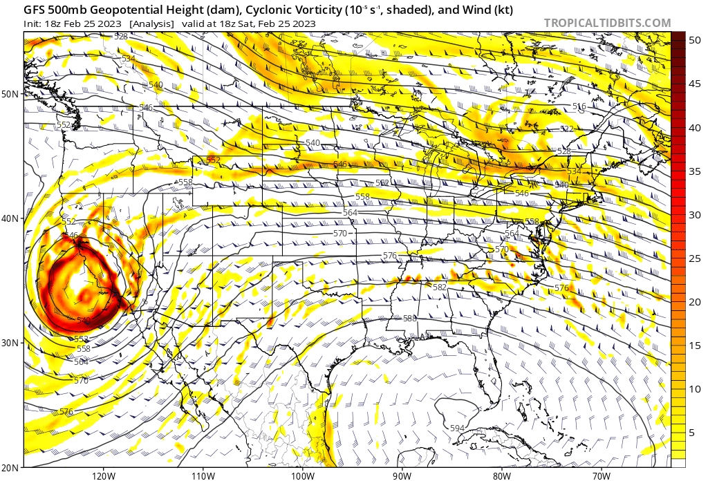
Above: a GFS 500mb loop showing the evolution of the California. Look at how it is strong in California, but gradually weakens as it heads east toward the Great Lakes. It then transfers enough energy off the coast to bring us our storm.
The Forecast
Our grade will be based on the following factors in our final call, which will be issued late tomorrow or very early Monday. We have gotten questions about why the models have seemed all over the place. Here's why.
Computer models are designed to take atmospheric data and make extremely complex calculations to project what the weather will be. It's more than just how much snow will fall or what the temperature will be at the surface. Guidance looks at everything from the upper level pattern to low level details. The upper level pattern drives our sensible weather.
In the whole scheme of things, models can't be trusted with details until we're inside 72 hours of an event, and even then, things constantly change. A degree or two warmer at 850mb, above the surface, can make the difference between snow or something else. This happens at many levels near the surface.
Overall, the models have shifted here because they have struggled with de-amplification. That has created a little chaos in temperature and total precipitation forecasts, along with the track. This is because of the interaction between the low pressure and the block in the Atlantic. That has more or less smoothed out, and as we get closer, I expect more alignment. Small changes aloft can still have big implications at the surface.
Timing
Most of Monday looks fine for travel. We expect to see snow develop from west to east around mid-afternoon, which is a little earlier than the guidance currently suggests. That may make the evening commute a little tricky but manageable as we look at things right now.
The heaviest snow occurs during the evening and overnight hours. Normally, that would reduce the impact and it does to an extent, but we expect snow to continue into Tuesday morning and possibly early afternoon, if the system does not introduce enough warming to change things over in southern CT.
Snow Accumulation
As the snow map shows, we expect most to see 4-8" with the shoreline seeing lower amounts. We need to break this down more, however.
We have fairly high confidence that this is a 4-8 event inland. Looking deeper, it's western CT that is most likely to have the highest amounts, and that may even reach down to the shoreline. In the CT River Valley, we always watch for dry slotting, and in eastern CT, this time it looks like we may not get the best lift to continue the streak of jackpots from snow event. Famous last words.
Bottom line, 4-8 is a good bet for interior CT.
Where I really have caution flags up is far southern CT. I need those peeps to read carefully here. Despite the 2-4 zone, this looks impactful. For our first call, the SCW team decided to be more conservative in case there is poorly modeled warmth, which obviously has been an issue this year, that cuts down on snow accumulation. The trend today has been to shift the warmth further south, meaning more snowfall when the storm is really going. In fact, the latest GFS and Euro are in agreement for now that even if there is a mix, that happens Tuesday morning after a widespread 4+ has fallen even down there.
As a result, for our first call we think it is reasonable to expect a floor of 2", but most will see snowfall of 3-4". These numbers may go up in the final call should we see a continued trend that keeps the warmth away and allows for less precipitation to be "wasted" on rain.
I do not anticipate the final call lowering the floor to say an inch or so. This should be plowable across Connecticut, especially given the timing of the heaviest snow.
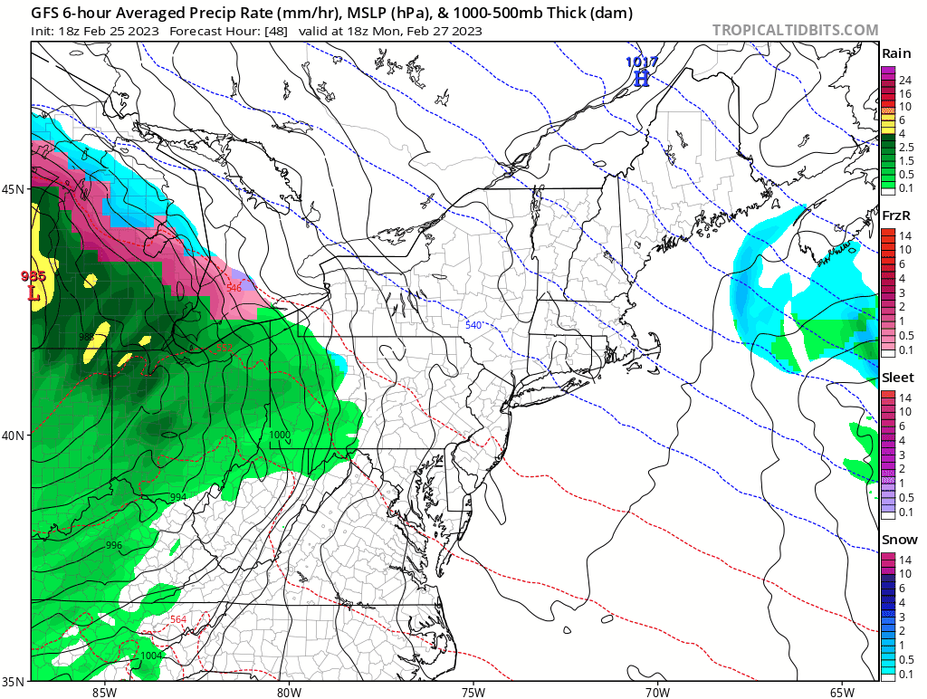
Above: the 18z GFS. As you can see, it's looking colder than prior runs, which increases confidence for now that our floor of 2" won't be touched in coastal CT. We watch the immediate shoreline. The heaviest snow ends Tuesday morning, but lighter snow is possible into the afternoon.
Impacts
The timing of the heaviest snow happening overnight and early Tuesday actually cuts both ways here for impact. On one hand, the timing means that most will be off the roads. On the other, it increases snow accumulation potential on roads as we won't have daytime insolation available to warm up roads and sidewalks. This should mean that Tuesday sees widespread cancellations, even at the shoreline. This is the best chance yet for a snow day...for those that have an interest in that kind of thing.
In addition, this is looking more like a paste than fluffy snow. That will have some impact as well in terms of shoveling. We don't expect significant power outages because we won't have a significant gradient or strong enough low to really crank the winds up. It'll be a little breezy at the coast, but nothing too bad.
Below is the 18z Euro depiction of surface temperatures. As you can see for inland CT, this is all snow with plenty of cold in place. For the immediate shoreline, we do need to watch but even here it looks cold enough for plowable snow. Although the temperatures rise late morning into afternoon, the bulk of the snow has fallen by then.
This looks like a moderate impact event.

Overall
For a winter that has essentially been the worst in recorded history, it's easy to feel like this one is going to fall apart right before it starts. If you need to see snow to believe it, I get it. I kind of do too.
However, given the data and our read of the pattern, this looks like a moderate impact event statewide, with plowable snow that likely turns Tuesday into a snow day.
Stay tuned as we will continue to refine the forecast. For southern CT folks, don't let the 2-4 zone make you tune this one out. While 2" is the floor we expect most to end up with 3-4", and there's a legitimate possibility those numbers go up if we continue to look colder closer to the storm arriving.
As always, please like, share, and interact with us on our social media--on Facebook to share our discussions, and follow us on Twitter @southernctwx to retweet our posts. Hit the buttons below to join.
Thank you for reading SCW.
-DB
