Good morning from SCW!
I hope you and your family are all happy and healthy on this Sunday morning. We've seen quite a pattern shift the past few weeks, going from a very warm winter to very cold spring. This long April is coming to an end, but the pattern is not. We will likely enter May with colder than normal temperatures and an active pattern. Although the measurable snow is likely done, the rain is not. Let's dive in.
I hope you and your family are all happy and healthy on this Sunday morning. We've seen quite a pattern shift the past few weeks, going from a very warm winter to very cold spring. This long April is coming to an end, but the pattern is not. We will likely enter May with colder than normal temperatures and an active pattern. Although the measurable snow is likely done, the rain is not. Let's dive in.
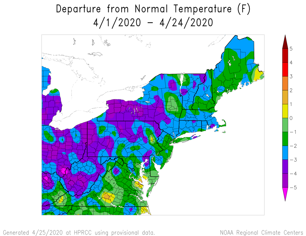
A recap of the temperature departure for the month of April. After a torch January, February, and March, April has been "cold".
Sunday-Monday
Clouds and rain showers moved in overnight in advance of a slow moving area of low pressure, and although there are more spotty showers currently, over the course of the day we will see more widespread rain. Unlike yesterday, today is much colder and wet throughout.
It's not much different on Monday, when the storm is expected to be offshore but still bring showers and colder than normal conditions to the state. Tomorrow looks like showers will be more spotty in nature, but for those that need to head out, it is an umbrella day.

Tuesday-Wednesday
The storm is slow to depart, but after some possible early showers on Tuesday things should clear out as a weak area of high pressure builds in. Tuesday is looking cooler than normal (theme of the week) but we should see decreasing clouds. Wednesday is a tricky day. I think the next storm system will be a bit delayed, but at the very least, I think we will see increasing clouds and an increasing chance of showers the further into the day we go. It doesn't not look terribly wet, but I will introduce some low chances for showers.
Thursday-Friday
More rain. Another low pressure system will approach the region and slowly move along, bringing rain and breezy conditions on Thursday and a lesser chance of showers on Friday. Temperatures look to be slightly warmer than the start of the week, but we will still be below normal. It seems the pattern is rinse and repeat!

The Weekend
Perhaps we have some light by the end of the week? As the latest storm departs, it looks like we may get a bit of a reprieve from the cool and wet pattern. Another area of high pressure may build in, bringing us a period of warmer and dry conditions, especially on Sunday. For now, I'll take the optimistic view. The overall trend is clear, however. Colder than normal conditions are likely to remain into May.
Perhaps we have some light by the end of the week? As the latest storm departs, it looks like we may get a bit of a reprieve from the cool and wet pattern. Another area of high pressure may build in, bringing us a period of warmer and dry conditions, especially on Sunday. For now, I'll take the optimistic view. The overall trend is clear, however. Colder than normal conditions are likely to remain into May.
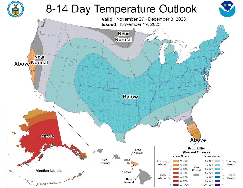
Climate Prediction Center (CPC) temperature outlook looking into early May. The probabilities of colder than normal conditions are high.
The Dailies
Sunday: Mostly cloudy with rain. Highs in the upper 40s to low 50s. Chance of rain 100%.
Monday: Mostly cloudy with rain showers. Highs in the mid to upper 40s. Chance of rain 70%.
Tuesday: Showers possible early with decreasing clouds during the day. Highs in the low to mid 50s. Chance of rain early 20%.
Wednesday: Partly sunny early with increasing clouds and showers by late. Highs in the mid to upper 50s. Chance of rain late 20%.
Thursday: Mostly cloudy with rain. Breezy. Highs in the mid to upper 50s. Chance of rain 70%.
Friday: Mostly cloudy with rain showers. Breezy. Highs in the upper 50s to low 60s. Chance of rain 50%.
Saturday: Decreasing clouds. Highs in the upper 50s.
As always, please like, share, and interact with us on our social media--on Facebook to share our discussions, and follow us on Twitter @southernctwx to retweet our posts. Hit the buttons below to join.
Thank you for reading SCW.
-DB
