A very good evening to you from Southern Connecticut Weather!
Today across the great state of Connecticut, was a blustery, very cold day. With temperatures hovering between the upper single digits to low teens, and winds approaching 20 to 25 mph, it was a nasty day to be outside. Although temperatures were frigid, we did enjoy plentiful sunshine. Currently, around the state, we have temperatures ranging from the single digits in northwest Connecticut to the mid teens in the southeastern part of the state with mostly clear skies. These temperatures will only drop slightly as we head through the evening, clouds will begin to roll in around midnight, and temperatures will begin to stabilize if not rise slightly.
Looking ahead to early tomorrow morning, skies will be mostly cloudy with the first fringes of snow flurries and showers beginning to reach the state. By mid morning, temperatures should be in the mid teens to 20s, at this time temperatures will not be as cold as they were today. I do see a mainly dry, snow-free morning across the state right through lunchtime, so if you do have any errands to run or traveling to do, it looks as if you will be in the clear.
Currently we have winter storm watches in effect for all counties except for Litchfield and Fairfield (where there is a winter weather advisory), high wind watches in effect for the shoreline, and a wind chill watch in effect for brutally cold wind chills in Litchfield county. So an exciting, and potentially dangerous few days of weather looks to be headed to our area.
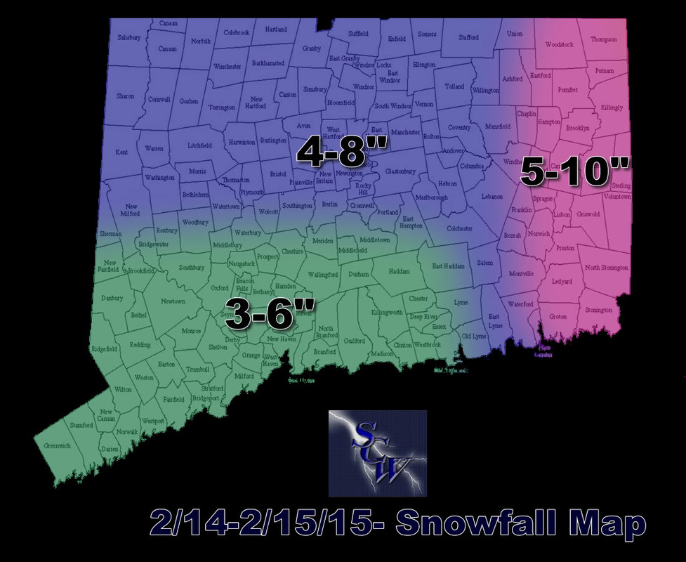
For Saturday afternoon and evening, conditions will be deteriorating rapidly. A shortwave, clipper system approaching from the west will initially spread steady light to moderate snow around the state early in the afternoon on Saturday. This clipper system will continue to track just off the coast and then rapidly intensity off the Massachusetts coastline. As of right now, the western 2/3s of the state look to be spared the worst of the snow, but the other third of the state looks to be in the bullseye for the highest impacts as far as wind and snow go. We are going with our first call snowfall map as our final call, with the highest accumulations still being in this eastern third of the state. As mentioned in the previous discussion, winds and frigid temperatures are a very big concern. In eastern sections, winds may exceed 50 mph, and with temperatures in the teens and low 20s, that spells danger in terms of wind chills if you need to be outside. For the rest of the state, the main impacts from this storm will be the frigid temperatures and high winds, snow looks to be a minor to moderate impact in these sections.
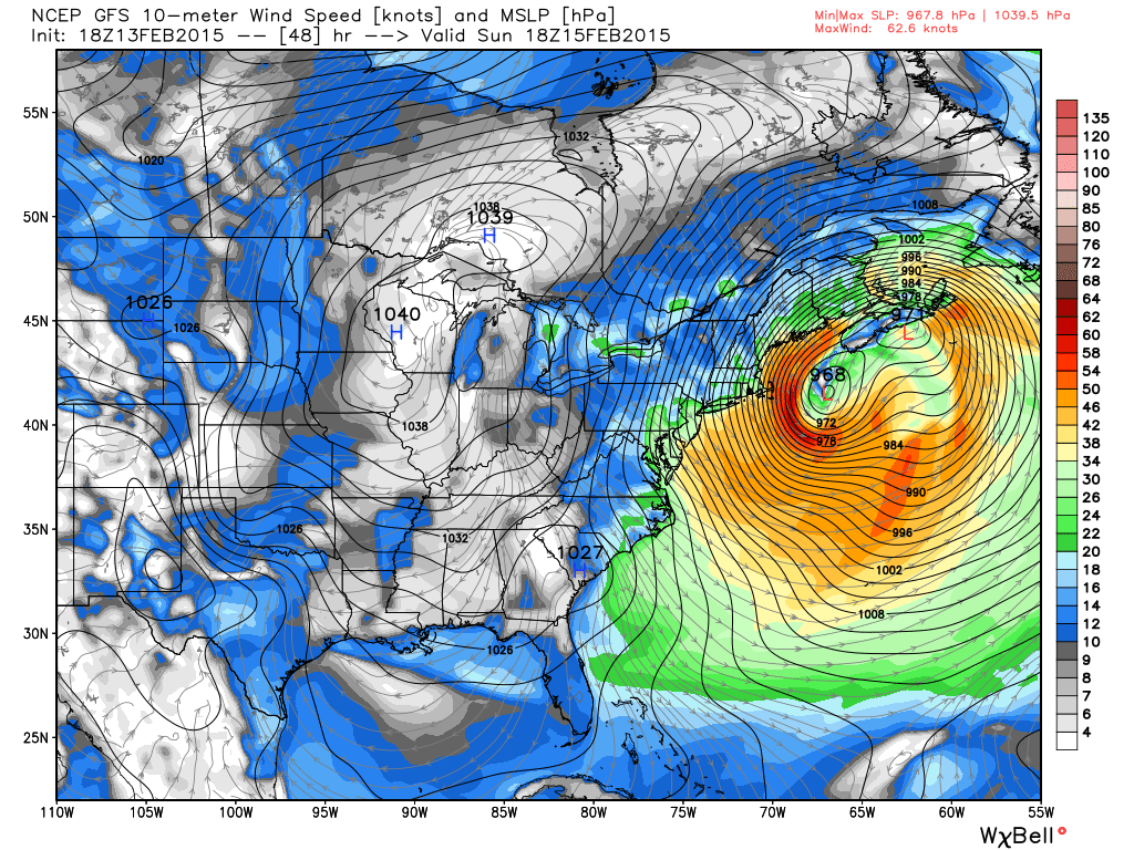
Saturday night through Sunday morning look to be the height of the storm, especially in eastern sections. Snow could be quite heavy at times during this period, with very strong northeast winds blowing, this is not a time to be outside. Temperatures will be in the teens to low 20s at this time and with winds howling at 40-60 mph, wind chills will be down below zero. Snow looks to be falling still in the eastern portion of the state even through the middle of Sunday morning. Precipitation does look to be pretty much done across the state by Sunday afternoon. As the storm exits the area to the north and east, winds will still be gusty and flip around to the northwest, temperatures will plummet throughout the day on Sunday, and by Sunday night will bottom out below zero across most of the state. A biting wind does look to still persist through this time, so combined with the sub zero temperatures, wind chills will be well into the dangerous range.
Have a good Friday evening everyone! Stay tuned to SCW for all the latest throughout the storm. Stay warm and stay safe!-Tim
