Good evening from SCW!
We’ve had an impressive run of cold temps the last few days, most notably Wednesday’s highs that would have been below normal in mid January across most of the state. While this weekend’s cold shot was not quite so extreme, it’s certainly been brisk, and a few snowflakes flying in spots cemented the wintry appeal. This week, while not quite so cold as last week, will continue to be below normal in most spots, but while there are some storm chances on the horizon we will likely have to continue to wait for our first widespread accumulating snowfall.
Monday-Tuesday
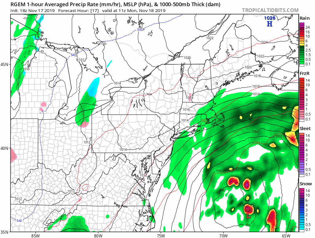
Winter Weather Advisories are in effect for tonight into tomorrow morning for some light freezing rain across our northern counties. A system tracking offshore had been previously modeled to bring heavier precipitation into the state, but over the last few model cycles has trended east and weaker. While we won’t see as much precipitation, it also means that the coastal front will be held further to the east than we otherwise would have expected, so if temps manage to cool off a bit tonight before the precip arrives we could see some freezing rain and/or freezing drizzle in the usual cold spots before things warm up tomorrow. I’m not convinced that we will see the temps/precip combo for widespread freezing rain otherwise, and no significant accretions are expected, but you don’t need much icing to cause issues on the roads. so please leave a little extra time tomorrow morning just in case.
We’ll see a quick decrease in the precipitation tomorrow afternoon before a strong band forms from the trailing low as the main system starts to lift NE. I expect that it will primarily bring more rain to the area tomorrow evening into the overnight, but depending on the timing of the cold front, a flash over to snow in the northwest hills is possible, and a quick inch of snow there late Monday night wouldn't surprise me. If you believe the NAM, this second band is our primary precipitation maker as the main system stays far enough out to sea that we aren’t impacted, but I think we’ll have at least some showers throughout the day tomorrow, especially in eastern areas.
Any lingering showers from the ULL should be gone by Tuesday morning, with clearing throughout the day. Highs Monday should be in the upper 30s, Tuesday will pop up into the mid 40s.
Here’s an overview of the system from the RGEM.
We’ve had an impressive run of cold temps the last few days, most notably Wednesday’s highs that would have been below normal in mid January across most of the state. While this weekend’s cold shot was not quite so extreme, it’s certainly been brisk, and a few snowflakes flying in spots cemented the wintry appeal. This week, while not quite so cold as last week, will continue to be below normal in most spots, but while there are some storm chances on the horizon we will likely have to continue to wait for our first widespread accumulating snowfall.
Monday-Tuesday
Winter Weather Advisories are in effect for tonight into tomorrow morning for some light freezing rain across our northern counties. A system tracking offshore had been previously modeled to bring heavier precipitation into the state, but over the last few model cycles has trended east and weaker. While we won’t see as much precipitation, it also means that the coastal front will be held further to the east than we otherwise would have expected, so if temps manage to cool off a bit tonight before the precip arrives we could see some freezing rain and/or freezing drizzle in the usual cold spots before things warm up tomorrow. I’m not convinced that we will see the temps/precip combo for widespread freezing rain otherwise, and no significant accretions are expected, but you don’t need much icing to cause issues on the roads. so please leave a little extra time tomorrow morning just in case.
We’ll see a quick decrease in the precipitation tomorrow afternoon before a strong band forms from the trailing low as the main system starts to lift NE. I expect that it will primarily bring more rain to the area tomorrow evening into the overnight, but depending on the timing of the cold front, a flash over to snow in the northwest hills is possible, and a quick inch of snow there late Monday night wouldn't surprise me. If you believe the NAM, this second band is our primary precipitation maker as the main system stays far enough out to sea that we aren’t impacted, but I think we’ll have at least some showers throughout the day tomorrow, especially in eastern areas.
Any lingering showers from the ULL should be gone by Tuesday morning, with clearing throughout the day. Highs Monday should be in the upper 30s, Tuesday will pop up into the mid 40s.
Here’s an overview of the system from the RGEM.
Wednesday-Thursday
Sunny and seasonably cool (but much warmer than last week!) under high pressure. Highs generally will be in the mid to upper 40s, with overnight temps near freezing.
Friday-Sunday
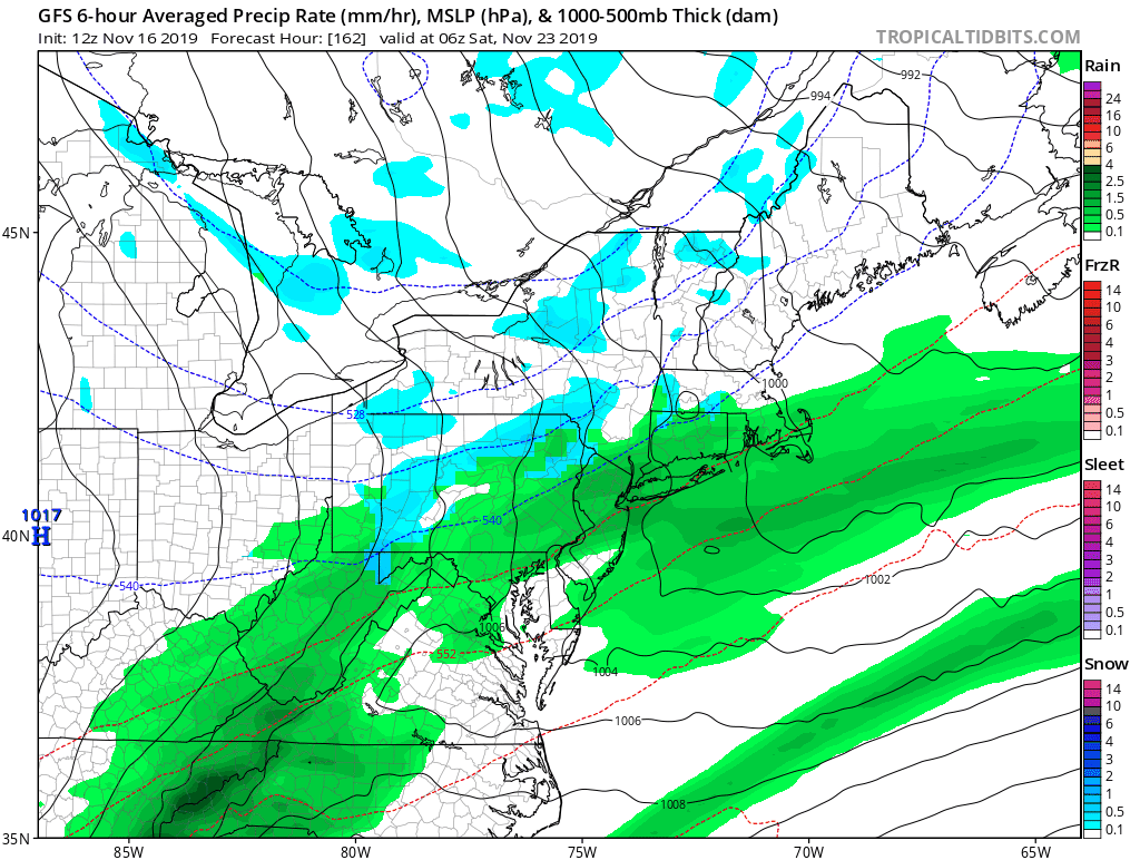
Things get foggier as we move into the weekend, with quite a few different shortwaves moving around. While the models generally have kept each relatively weak, the occasional run has chosen to key in on a particular piece of energy and blow it up into a larger system. For now, the consensus is for some showers on Friday and possibly again Sunday should an offshore low track closer to the coast, but confidence is low. Will include chance pops in the dailies for Friday and Sunday, focusing more on Friday as it looks like that’s more of a sure thing, but we’ll need to get some more clarity in the guidance as we move through the week to confirm.
Here’s a look at a few recent GFS runs for 1 AM Saturday - quite a few different sensible weather solutions here, so we’ll need to keep watching to see where a consensus develops.
Sunny and seasonably cool (but much warmer than last week!) under high pressure. Highs generally will be in the mid to upper 40s, with overnight temps near freezing.
Friday-Sunday
Things get foggier as we move into the weekend, with quite a few different shortwaves moving around. While the models generally have kept each relatively weak, the occasional run has chosen to key in on a particular piece of energy and blow it up into a larger system. For now, the consensus is for some showers on Friday and possibly again Sunday should an offshore low track closer to the coast, but confidence is low. Will include chance pops in the dailies for Friday and Sunday, focusing more on Friday as it looks like that’s more of a sure thing, but we’ll need to get some more clarity in the guidance as we move through the week to confirm.
Here’s a look at a few recent GFS runs for 1 AM Saturday - quite a few different sensible weather solutions here, so we’ll need to keep watching to see where a consensus develops.
The Dailies
Monday: Showers likely with a chance of freezing rain, otherwise, mostly cloudy, with highs in the mid to upper 30s. Chance of precipitation is 60%.
Tuesday: Showers ending, then clearing, with highs in the mid to upper 40s. Chance of precipitation is 40%.
Wednesday: Mostly sunny, with highs in the mid to upper 40s.
Thursday: Mostly sunny, with highs in the mid to upper 40s.
Friday: A chance of rain, otherwise, mostly cloudy, with with highs in the low to mid 50s. Chance of rain is 40%.
Saturday: Partly sunny, with highs in the low to mid 40s.
Sunday: A chance of showers, otherwise, partly cloudy, with highs in the low to mid 40s. Chance of precipitation is 30%.
Have a great week and thank you for reading SCW!
-SA
