Good evening to you from Southern Connecticut Weather!
After a seasonably cold weekend, we look to warm up for the upcoming week, but first we’ll have a messy storm to deal with tomorrow into Wednesday. While it should be too warm for a significant snow event, we will likely see some accumulating snow in northern areas, and there is a threat for some icing as well.
Tuesday-Wednesday
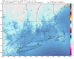
As mentioned above, we’re dealing with a messy system in the near term of this forecast. The system is currently located over the plains and coming eastward, reaching our area by tomorrow afternoon. As the storm is once again tracking west of us(A common theme this winter considering our lack of blocking), this will allow for warmer air to make its way into the area tomorrow, sending daytime highs well above freezing – upper 30s to lower 40s will be the rule. Temps will cool before precipitation arrives tomorrow afternoon, but the fact that we’re not starting with a very cold airmass makes me less worried about a significant icing threat.
After a seasonably cold weekend, we look to warm up for the upcoming week, but first we’ll have a messy storm to deal with tomorrow into Wednesday. While it should be too warm for a significant snow event, we will likely see some accumulating snow in northern areas, and there is a threat for some icing as well.
Tuesday-Wednesday
As mentioned above, we’re dealing with a messy system in the near term of this forecast. The system is currently located over the plains and coming eastward, reaching our area by tomorrow afternoon. As the storm is once again tracking west of us(A common theme this winter considering our lack of blocking), this will allow for warmer air to make its way into the area tomorrow, sending daytime highs well above freezing – upper 30s to lower 40s will be the rule. Temps will cool before precipitation arrives tomorrow afternoon, but the fact that we’re not starting with a very cold airmass makes me less worried about a significant icing threat.
For the southern portion of the state, this system should be mostly if not all rain. We could see a quick period of wintry mix at the start, but surface temperatures will rise above freezing and cause any wintry precipitation to change over to rain. Further north, things are a bit more complicated. Most of the northern portion of the state will wetbulb down as precipitation arrives and brings cooler air down through the column, and as such, I think a quick period of snow is likely for the northern tier tomorrow evening. Accumulations will likely be minimal, but the higher elevations could see an inch or two if the system comes in on the cold side. A changeover to sleet and freezing rain will then occur as warm air moves into the midlevels.
What happens next is still somewhat uncertain. As said previously, as the storm continues to move north and draw up warm air, midlevel temperatures will rise above freezing, ending any threat of snow. However, what happens at the surface is still somewhat unclear. Right now, most guidance agrees that the Litchfield hills will lock in the cold air at least through the evening, and icing is expected there as a result. High-res guidance is showing between a quarter and a half of an inch of ice accretion; while I don’t expect that much, I do expect a moderate period of icing, with some impacts to power lines and trees possible and definitely some challenging travel conditions.
Outside of the hills, the guidance suggests that everything will warm enough up to see just plain rain. While I think that is the most likely outcome, I am a bit worried about low level cold holding on in the typical cold spots (elevated valleys, sheltered areas, etc.), and some icing occurring as a result. The best chance of that would be in the Tolland hills, although areas of Windham County could get in on that as well. Otherwise, a cold rain will be the theme of the evening for the state.
Precipitation should change over to plain rain across the state overnight Tuesday, and rain will likely continue through the commute on Wednesday morning before tapering off. Overall, a relatively low impact event, but icing can be sneaky and can cause serious problems, so make sure to keep an eye on our social media pages for updates as needed tomorrow and don’t travel if icing conditions are taking place in your area.
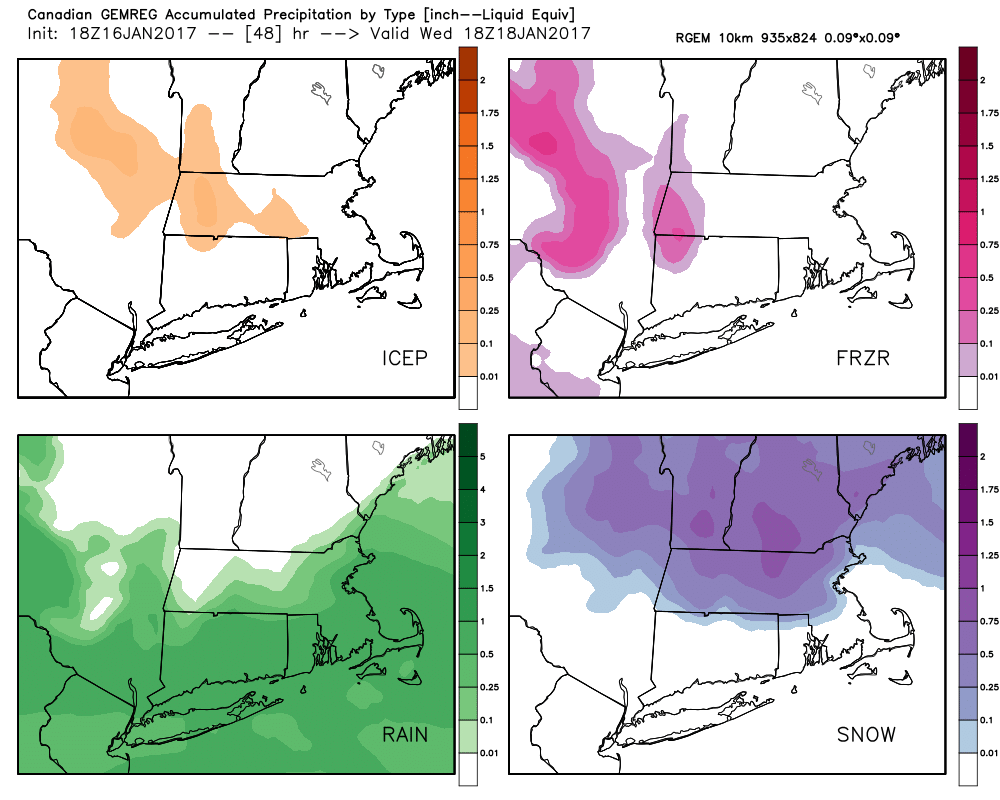
Here's a look at precipitation type on the RGEM; you can see that outside of a bit of snow across the northern tier and the aforementioned icing in the northwest hills, this is mostly a rain event verbatim. This also shows that the colder air is not far away to our north, and it wouldn't take much of a shift in the forecast to be a larger producer of wintry weather, so we're keeping a close eye on the last minute trends.
What happens next is still somewhat uncertain. As said previously, as the storm continues to move north and draw up warm air, midlevel temperatures will rise above freezing, ending any threat of snow. However, what happens at the surface is still somewhat unclear. Right now, most guidance agrees that the Litchfield hills will lock in the cold air at least through the evening, and icing is expected there as a result. High-res guidance is showing between a quarter and a half of an inch of ice accretion; while I don’t expect that much, I do expect a moderate period of icing, with some impacts to power lines and trees possible and definitely some challenging travel conditions.
Outside of the hills, the guidance suggests that everything will warm enough up to see just plain rain. While I think that is the most likely outcome, I am a bit worried about low level cold holding on in the typical cold spots (elevated valleys, sheltered areas, etc.), and some icing occurring as a result. The best chance of that would be in the Tolland hills, although areas of Windham County could get in on that as well. Otherwise, a cold rain will be the theme of the evening for the state.
Precipitation should change over to plain rain across the state overnight Tuesday, and rain will likely continue through the commute on Wednesday morning before tapering off. Overall, a relatively low impact event, but icing can be sneaky and can cause serious problems, so make sure to keep an eye on our social media pages for updates as needed tomorrow and don’t travel if icing conditions are taking place in your area.
Here's a look at precipitation type on the RGEM; you can see that outside of a bit of snow across the northern tier and the aforementioned icing in the northwest hills, this is mostly a rain event verbatim. This also shows that the colder air is not far away to our north, and it wouldn't take much of a shift in the forecast to be a larger producer of wintry weather, so we're keeping a close eye on the last minute trends.
Thursday-Sunday
Warm and quiet weather to end the workweek as high pressure moves over the area. For the upcoming weekend, the GFS and Euro differ somewhat; both have a system in our general area; the GFS keeps it suppressed to our south while the Euro brings it further north and results in some light rain Friday night into Saturday. Will add low chance pops to the forecast and allow Greg to look at this more tomorrow once we’ve seen another round of model data. Temps should stay well above normal through the weekend. Next system approaches early next week; models are all over the map on this one with both temperature and precipitation; will call it a chance of rain and snow and refine as we move further ahead in time.
The Dailies
Tuesday: A chance of rain in the morning, then a wintry mix likely in the afternoon and evening. Highs in the upper 30s to lower 40s. Chance of precipitation is 90%.
Wednesday: A chance of rain, otherwise, mostly cloudy, with highs in the upper 30s. Chance of precipitation is 60%.
Thursday: Partly sunny, with highs in the mid to upper 40s.
Friday: Partly sunny, with highs in the low to mid 40s.
Saturday: A chance of showers, otherwise, partly cloudy, with highs in the low to mid 40s.
Sunday: Partly sunny, with highs in the low to mid 40s.
Monday: A chance of rain or snow, otherwise, partly cloudy, with highs in the low 40s. Chance of precipitation is 30%.
Have a great start to your week and thank you for reading SCW!
-SA
