Happy new year from SCW! We’re excited for the year ahead and we thank you for continuing to make us your source for reliable, relatable, and hype-free forecasting for Connecticut.
The first weekend of 2020 looks active, with both rain and snow chances in the forecast, and chances for precipitation look to continue into next week. Let’s dive into the details.
Friday
Cloudy with a chance of showers as the northern edge of a strong coastal system passes over the state. It looks like we’ll see two distinct periods of showers, one first thing in the morning and then another towards the evening hours; best chance of being dry will likely be during the afternoon. Southern areas should see the most QPF, but amounts will be relatively light, and I don’t expect a washout to occur anywhere. Temps near to slightly above seasonal normals in the low to mid 40s.
Saturday-Sunday
*SCW Period of Interest*
Our first SCW period of interest for 2020 arrives this weekend as a redeveloping surface low off of a front brings a chance of precipitation to the state for Saturday through Sunday morning.
Models have been all over the place with this system, with solutions ranging from a weak frontal passage to a warm rainstorm to a dynamics driven snow event. The general trend today has been to weaken the system, but occasional model runs have continued to show a more amplified solution. In order to get significant snow, we’ll need the system to intensify far enough SW that there’s still enough QPF left to fall as snow post changeover; a more progressive solution may bring a changeover, but there won’t be enough QPF for more than a light accumulation post front. The weaker solutions are also a bit faster, with rain coming in during the daytime on Saturday as opposed to after dark.
Current model consensus agrees that rain will overspread the state over the course of Saturday morning and will continue through the day Saturday. Some solutions pull out precipitation entirely by Saturday night and leave Sunday dry, while others keep showers / snow showers around through Sunday morning. The stronger solutions bring a period of snow to the state early Sunday morning as the system deepens and a stronger precipitation shield develops, but those solutions are in the minority right now and I don’t think we’ve seen support for those sorts of solutions so far this winter.
Overall, I think this is a relatively low impact event that is mostly/all rain, but there is a low probability for a much more significant snow event should the redevelopment trend back towards what we were seeing on guidance earlier this week. Should it be needed, we’ll have a first call map tomorrow, but as of now I think it’s relatively unlikely.
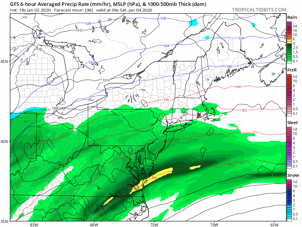
Here’s a look at the system on the GFS, it’s one of the weaker solutions but I think it represents the model consensus well right now.
The first weekend of 2020 looks active, with both rain and snow chances in the forecast, and chances for precipitation look to continue into next week. Let’s dive into the details.
Friday
Cloudy with a chance of showers as the northern edge of a strong coastal system passes over the state. It looks like we’ll see two distinct periods of showers, one first thing in the morning and then another towards the evening hours; best chance of being dry will likely be during the afternoon. Southern areas should see the most QPF, but amounts will be relatively light, and I don’t expect a washout to occur anywhere. Temps near to slightly above seasonal normals in the low to mid 40s.
Saturday-Sunday
*SCW Period of Interest*
Our first SCW period of interest for 2020 arrives this weekend as a redeveloping surface low off of a front brings a chance of precipitation to the state for Saturday through Sunday morning.
Models have been all over the place with this system, with solutions ranging from a weak frontal passage to a warm rainstorm to a dynamics driven snow event. The general trend today has been to weaken the system, but occasional model runs have continued to show a more amplified solution. In order to get significant snow, we’ll need the system to intensify far enough SW that there’s still enough QPF left to fall as snow post changeover; a more progressive solution may bring a changeover, but there won’t be enough QPF for more than a light accumulation post front. The weaker solutions are also a bit faster, with rain coming in during the daytime on Saturday as opposed to after dark.
Current model consensus agrees that rain will overspread the state over the course of Saturday morning and will continue through the day Saturday. Some solutions pull out precipitation entirely by Saturday night and leave Sunday dry, while others keep showers / snow showers around through Sunday morning. The stronger solutions bring a period of snow to the state early Sunday morning as the system deepens and a stronger precipitation shield develops, but those solutions are in the minority right now and I don’t think we’ve seen support for those sorts of solutions so far this winter.
Overall, I think this is a relatively low impact event that is mostly/all rain, but there is a low probability for a much more significant snow event should the redevelopment trend back towards what we were seeing on guidance earlier this week. Should it be needed, we’ll have a first call map tomorrow, but as of now I think it’s relatively unlikely.
Here’s a look at the system on the GFS, it’s one of the weaker solutions but I think it represents the model consensus well right now.
Monday-Tuesday
Could see some snow showers on Monday as as a clipper passes to the north; this is fairly strong on the NAM and much weaker on most other models. I suspect this is just the NAM being its usual overamped self, but will include slight chance pops to account for the possibility of some rouge snow showers; best chances would be in the NW hills.
Otherwise, expect a break in the action as high pressure persists to the south, we’ll have seasonable to slightly above normal temps and partly sunny skies. Depending on timing, precipitation for the next system may arrive Tuesday afternoon, but as of now I think things hold off until Tuesday evening.
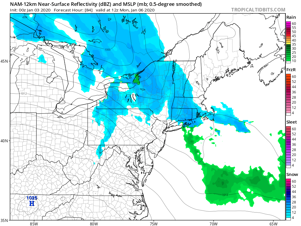
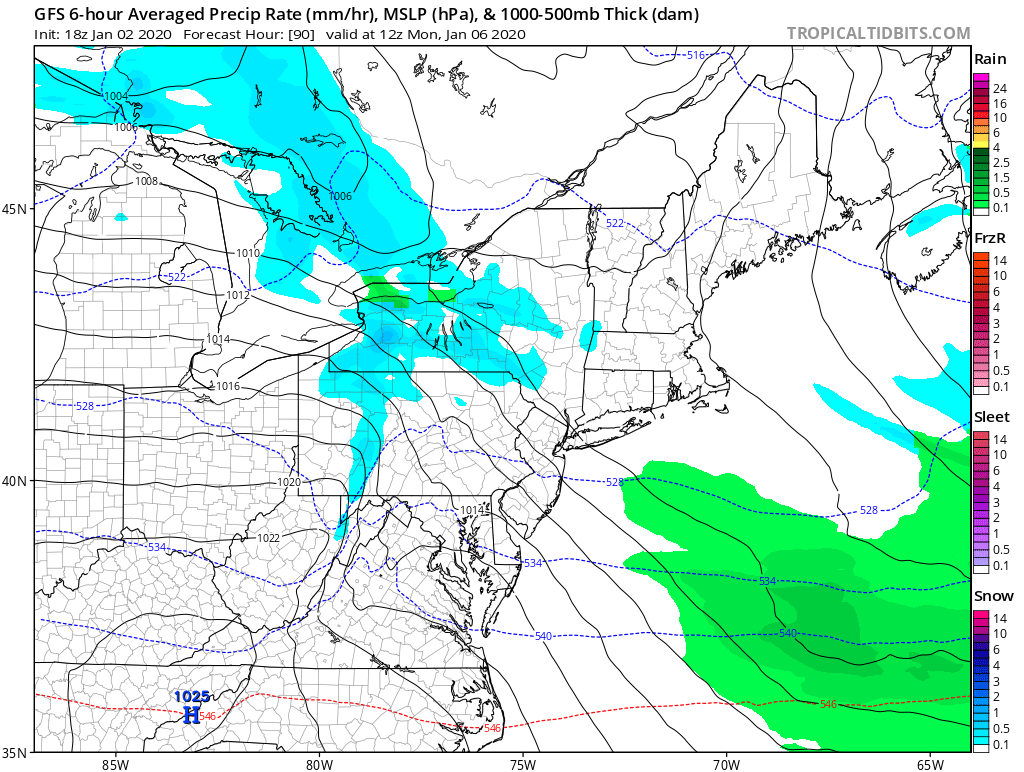
Here's the stronger NAM vs the weaker GFS, the GFS represents the consensus on most guidance except the NAM and to a lesser extent the Euro.
Could see some snow showers on Monday as as a clipper passes to the north; this is fairly strong on the NAM and much weaker on most other models. I suspect this is just the NAM being its usual overamped self, but will include slight chance pops to account for the possibility of some rouge snow showers; best chances would be in the NW hills.
Otherwise, expect a break in the action as high pressure persists to the south, we’ll have seasonable to slightly above normal temps and partly sunny skies. Depending on timing, precipitation for the next system may arrive Tuesday afternoon, but as of now I think things hold off until Tuesday evening.
Here's the stronger NAM vs the weaker GFS, the GFS represents the consensus on most guidance except the NAM and to a lesser extent the Euro.
Wednesday-Thursday
*SCW Period of Interest*
The next system looks to approach for midweek, with precipitation starting as early as Tuesday night. All models are in good agreement that a primary low cuts to the west and then spawns a secondary off the coast, but the details of airmass, track, and timing are still well up in the air. Solutions on the guidance range from an all snow event to a messy mix to mostly rain. GIven that we once again will have a marginal airmass ahead of the storm, my money would hedge towards another mixed bag, but there’s plenty of time for changes as the storm is almost a week out. We’ll keep an eye on it and have more details for you over the weekend should it continue to remain on the models.
The Dailies
Friday: Showers likely, otherwise, mostly cloudy, with highs in the low to mid 40s. Chance of precipitation is 70%.
Saturday: SCW Period of Interest. Rain likely, otherwise, cloudy, with highs in the upper 30s to lower 40s. Chance of precipitation is 80%.
Sunday: SCW Period of Interest. A chance of rain and snow, otherwise, mostly cloudy, with highs in the mid to upper 30s. Chance of precipitation is 40%.
Monday: A slight chance of snow showers, otherwise, partly cloudy, with highs in the upper 30s. Chance of precipitation is 20%.
Tuesday: Partly sunny, with highs in the upper 30s to lower 40s.
Wednesday: SCW Period of Interest. A chance of rain and snow, otherwise, mostly cloudy with highs in the mid to upper 30s. Chance of precipitation is 50%.
We’ll update tomorrow should any changes to the weekend forecast be necessary, until then, happy new year once again and thank you for reading SCW!
-SA
