A very chilly good evening to you from Southern Connecticut Weather!
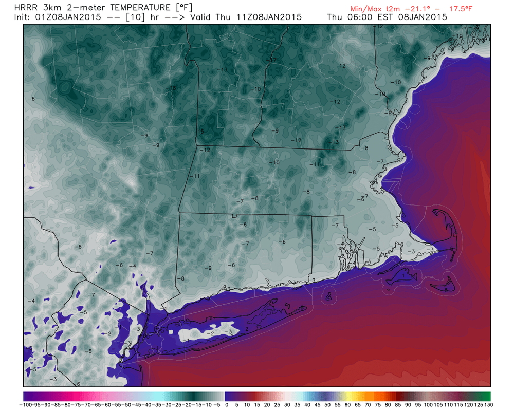
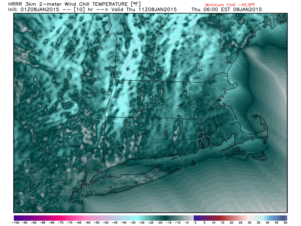
The coldest airmass of the season has descended on the state from the arctic, and we’re certainly feeling it on the surface, with temps across the state currently in the single digits inland to low 10s on the shoreline. Wind chills are even lower, with the entire state already below zero and heading lower, hitting -10 to -15 on the shoreline and up to -25 to -30 inland! As a result, a Wind Chill Advisory has been posted for the entire state from the NWS. While the actual temperature won’t be quite so cold, it will still be frigid, with short range guidance in good agreement on a bottom early tomorrow morning of below zero for the entire state except for possibly the immediate coastline. In general, expecting lows between 5 and 10 degrees below zero for the interior and 5 below to 5 above for the coast. Here’s maps p of forecast temps and wind chills at 6 AM tomorrow morning from the short range hourly HRRR. Bundle up!
The coldest airmass of the season has descended on the state from the arctic, and we’re certainly feeling it on the surface, with temps across the state currently in the single digits inland to low 10s on the shoreline. Wind chills are even lower, with the entire state already below zero and heading lower, hitting -10 to -15 on the shoreline and up to -25 to -30 inland! As a result, a Wind Chill Advisory has been posted for the entire state from the NWS. While the actual temperature won’t be quite so cold, it will still be frigid, with short range guidance in good agreement on a bottom early tomorrow morning of below zero for the entire state except for possibly the immediate coastline. In general, expecting lows between 5 and 10 degrees below zero for the interior and 5 below to 5 above for the coast. Here’s maps p of forecast temps and wind chills at 6 AM tomorrow morning from the short range hourly HRRR. Bundle up!
Temperatures will moderate over the course of the day tomorrow, with highs in the upper teens to around 20 being reached likely in the evening hours. Skies should be partly sunny, with clouds building late in the day into the evening hours in preparation for our next shot at some snow Friday morning.
An arctic front will come through Friday morning from our northwest, accompanied by another clipper system that could bring a band of snow squalls through the state. While guidance is in good agreement that this band will be more organized and thus have better coverage than the one that we saw today, various models differ on what areas have the best chance of seeing enhanced precipitation. Given that these systems usually favor the NW hills for the highest totals as they are able to “wring out” the most liquid and that the system is coming from the NW and as a result will hit that area first (while it still has more moisture), I feel comfortable forecasting one to three inches of snow for the NW hills.
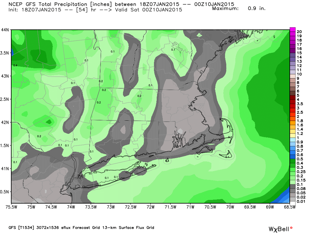
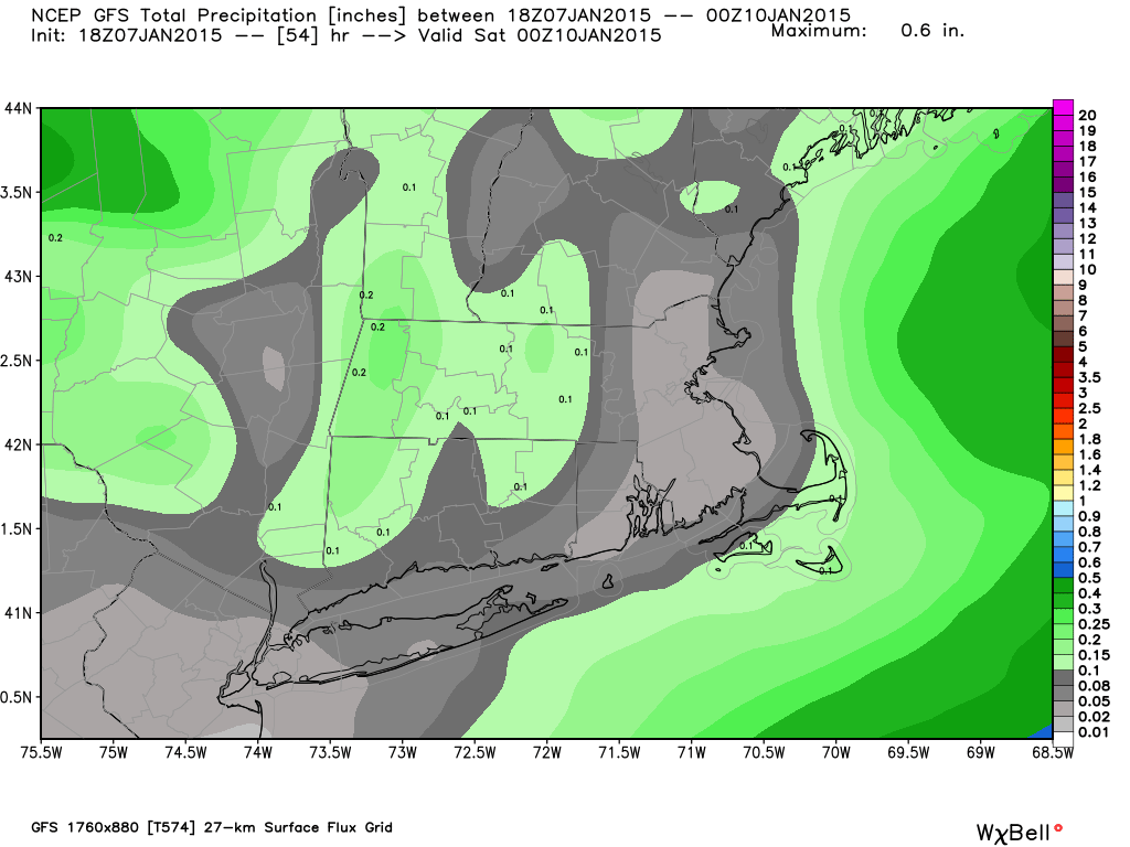
For the rest of the state, the picture is still unclear. Various guidance differs on how long it keeps the band of snow together before dissipating it, and when it does, it differs on where it remains intact. Below are total precipitation maps from the various models(4kmNAM, Parallel GFS, GGEM, GFS, NAM), notice the wide discrepancy on what areas the band chooses to jackpot. We can’t show the 12z EURO because of copyright issues, but generally, it’s favoring eastern areas.
An arctic front will come through Friday morning from our northwest, accompanied by another clipper system that could bring a band of snow squalls through the state. While guidance is in good agreement that this band will be more organized and thus have better coverage than the one that we saw today, various models differ on what areas have the best chance of seeing enhanced precipitation. Given that these systems usually favor the NW hills for the highest totals as they are able to “wring out” the most liquid and that the system is coming from the NW and as a result will hit that area first (while it still has more moisture), I feel comfortable forecasting one to three inches of snow for the NW hills.
For the rest of the state, the picture is still unclear. Various guidance differs on how long it keeps the band of snow together before dissipating it, and when it does, it differs on where it remains intact. Below are total precipitation maps from the various models(4kmNAM, Parallel GFS, GGEM, GFS, NAM), notice the wide discrepancy on what areas the band chooses to jackpot. We can’t show the 12z EURO because of copyright issues, but generally, it’s favoring eastern areas.


Given the spread remaining on modeling and the inherent uncertainty with banded systems in that the highest totals are almost exclusively dependent on where the best banding sets up and where the best atmospheric lift is, do not have enough confidence at this time to accurately pinpoint the other areas where more appreciable snow totals will fall. As a result, will forecast a coating to two inches for the rest of the state, with the possibility of some areas(Likely the NE hills) being upped to 1-3” tomorrow afternoon when we get a better look at guidance and hopefully some sort of consensus.
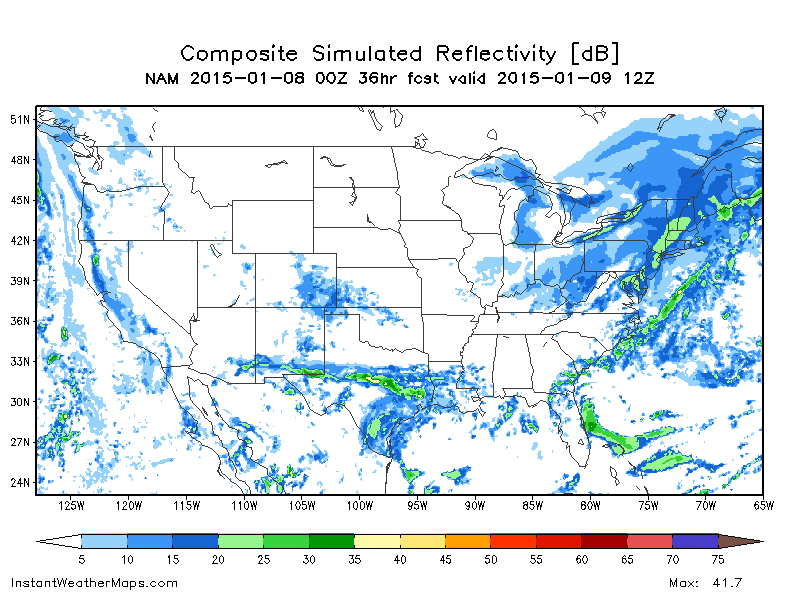
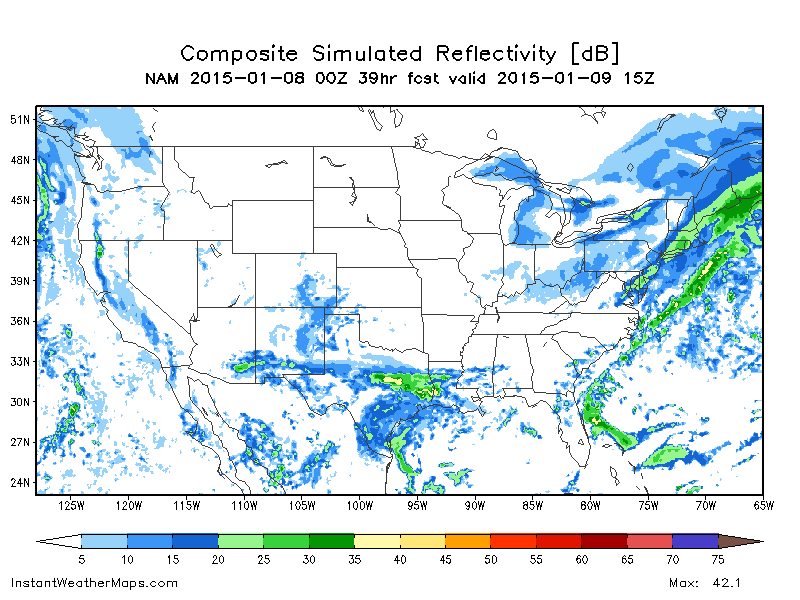
It’s important to note that this snow will not be a light accumulation over a long period of time like what we saw on Tuesday, but rather a brief 2-3 hour window of moderate to heavy snow, likely accumulating at over 1” per hour in some spots at times. When we look at simulated radar images, we can see that this storm is moving quickly, but while it’s short in duration, it’s strong in intensity, and as a result driving conditions will deteriorate for the period when the snow is impacting your area. Unfortunately, the timing of this event looks to be partially during the morning commute, and as a result, we’ll probably be seeing some tricky travel and slowdowns for the commute, at least in NW areas which will get the meat of the band during the commute. We could also see some delayed openings for schools on Friday, although a lot of that will depend on the timing of the band, which we won’t know exactly until Friday morning.
Here’s those sim radar images mentioned earlier, valid for 7 AM, 10 AM, and 1 PM, from the 0z NAM model. Generally, shades of blue represent lighter snows, while shades of green represent moderate to heavy snows.

We’ll have more on this system tomorrow after we get a chance to review the latest model guidance, and will likely issue a snow map tomorrow with hopefully a bit more detail than we went into to this evening. We’ll also have more details on timing as well at that time. Overall, a relatively light event, but the potential to have a high impact considering it falls right in the middle of the morning commute for most areas. We’ll be up bright and early Friday morning watching the radar, and will update continuously throughout the commute to bring you the most up to date info possible!
Behind this system, we’ll see slightly warmer temps than we saw on Thursday, with highs generally in the mid 20s for most areas.
Your weekend forecast looks pretty nice right now, with sunny skies making highs in the low 20s Saturday and upper 20s to lower 30s Sunday not feeling as cold as they would otherwise. Given the sunshine, moderated temps, and a week of cold for snowmaking plus a natural refresher on Friday, this should be a great weekend to hit the slopes. If skiing isn’t your thing, you’ll find beautiful scenery on the hiking trails around the state given the fresh snowcover, or even a stroll around town will feel nice with the sun on your neck. Whatever you choose to do, it should be a great weekend to be outside enjoying the sunshine! No precipitation is expected for this weekend.
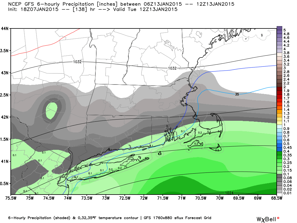
The forecast becomes muddier towards the end of the period, as a wave of overrunning precipitation is possible for early next week along a cold front. However, guidance is split completely on where it is focused and what sort of airmass we are dealing with. Given the arctic high in place and models tendency to underdo low level cold in the long range, am inclined to lean towards a colder solution, but than can also mean a miss to our south as the cold is too strong and acts as a “block” to stop precipitation from coming north into our area. Until we get a little closer to this system and can see some more data(and hopefully start to see some sort of trend or consensus), will refrain from going into more details, but as of now, a chance of snow(~30%) is possible for early next week, with the most precipitation(Not necessarily snow as temps will be the warmest there), on the south coast. Temperatures will depend on the eventual storm track, but for now, expect seasonable temps around the freezing mark for highs. Here’s a look at the overrunning precip on the GFS, but keep in mind this is just one of many possible scenarios shown on guidance.
Behind this system, we’ll see slightly warmer temps than we saw on Thursday, with highs generally in the mid 20s for most areas.
Your weekend forecast looks pretty nice right now, with sunny skies making highs in the low 20s Saturday and upper 20s to lower 30s Sunday not feeling as cold as they would otherwise. Given the sunshine, moderated temps, and a week of cold for snowmaking plus a natural refresher on Friday, this should be a great weekend to hit the slopes. If skiing isn’t your thing, you’ll find beautiful scenery on the hiking trails around the state given the fresh snowcover, or even a stroll around town will feel nice with the sun on your neck. Whatever you choose to do, it should be a great weekend to be outside enjoying the sunshine! No precipitation is expected for this weekend.
The forecast becomes muddier towards the end of the period, as a wave of overrunning precipitation is possible for early next week along a cold front. However, guidance is split completely on where it is focused and what sort of airmass we are dealing with. Given the arctic high in place and models tendency to underdo low level cold in the long range, am inclined to lean towards a colder solution, but than can also mean a miss to our south as the cold is too strong and acts as a “block” to stop precipitation from coming north into our area. Until we get a little closer to this system and can see some more data(and hopefully start to see some sort of trend or consensus), will refrain from going into more details, but as of now, a chance of snow(~30%) is possible for early next week, with the most precipitation(Not necessarily snow as temps will be the warmest there), on the south coast. Temperatures will depend on the eventual storm track, but for now, expect seasonable temps around the freezing mark for highs. Here’s a look at the overrunning precip on the GFS, but keep in mind this is just one of many possible scenarios shown on guidance.
We’ll have more on Friday morning’s snow tomorrow, but until then, have a great night and thanks for reading Southern Connecticut Weather!
-SA
-SA
