Good early early morning to you from Southern Connecticut Weather!
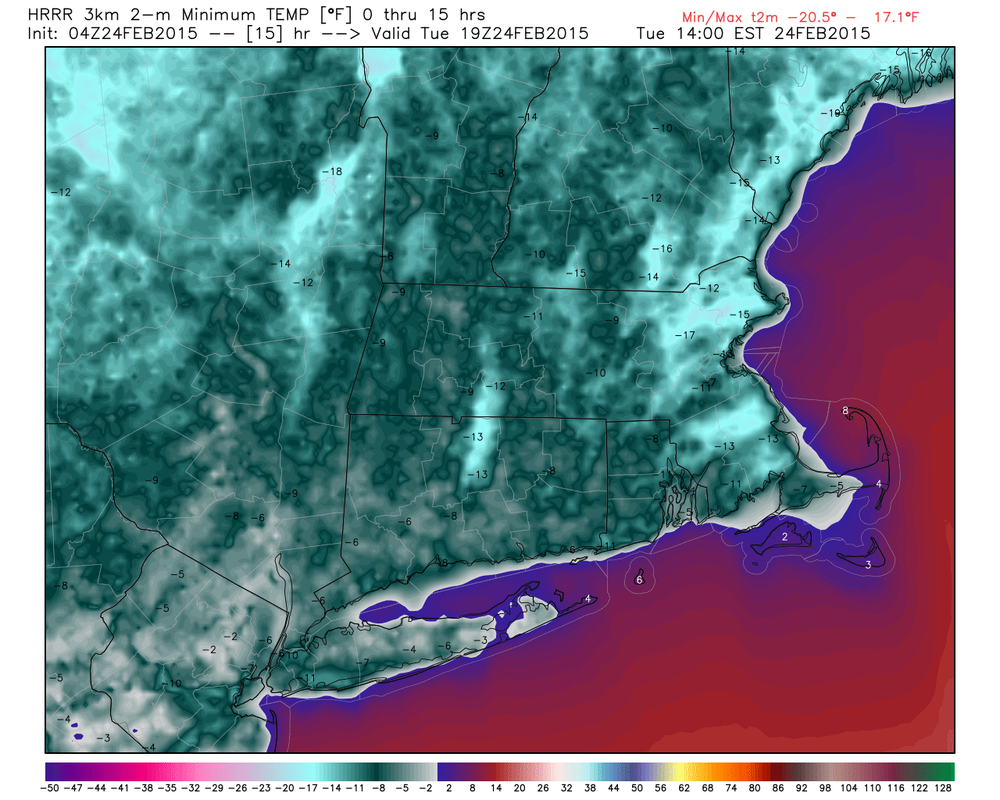
It's another very cold night in the state, with locations across the state hovering on either side of zero and steadily dropping. Radiational cooling will continue throughout the night, and by morning, everywhere in the state should be below zero, and northern parts of the state and higher elevations will be in the double digit negatives! As a result, a Wind Chill Advisory has been issued until mid-day for the northern four counties from the NWS for wind chills of fifteen to twenty degrees below zero. Bundle up when you're heading outside! Some school districts have announced delayed openings for this morning, so make sure to check with your district before you wake the kids up to get ready!
It's another very cold night in the state, with locations across the state hovering on either side of zero and steadily dropping. Radiational cooling will continue throughout the night, and by morning, everywhere in the state should be below zero, and northern parts of the state and higher elevations will be in the double digit negatives! As a result, a Wind Chill Advisory has been issued until mid-day for the northern four counties from the NWS for wind chills of fifteen to twenty degrees below zero. Bundle up when you're heading outside! Some school districts have announced delayed openings for this morning, so make sure to check with your district before you wake the kids up to get ready!
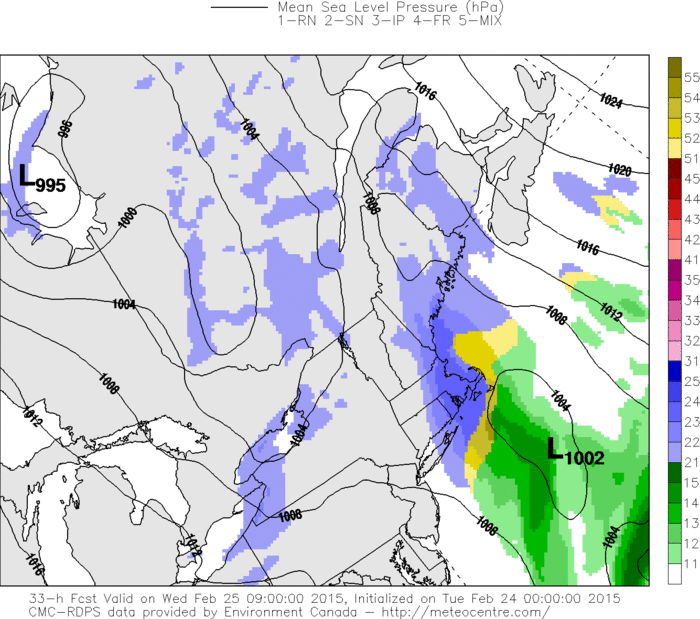
For those of you who are sick of this cold, unfortunately, the upcoming week looks like we'll be seeing a lot of it, although in general we will be a bit more moderated this week than we were last week, especially as we push towards the weekend. However, the dailies will remain below normal throughout the period, so don't get your hopes up for the arrival of spring anytime soon. As far as precipitation goes, we are watching a chance for a bit of snow in eastern areas late tomorrow evening into Wednesday morning from an Inverted Trough that develops to our east on the NW flank of a coastal low. This could bring an inch or two of snow to the SE corner of the state and perhaps some flurries or snow showers across the remainder, but in general, not expecting this to be a big deal at all and in fact think most areas west of I91 will see nothing at all. Otherwise, dry conditions look to continue throughout the period. There is a system that is currently modeled to pass well SE of us for Thursday night into Friday that we are keeping an eye on just in case, but for now, think it will be far enough out to sea to spare us from accumulating snow. Overall, a quiet and cold week looks to be in the cards.
Here are the dailies:
Tuesday: Sunny and cold, with highs in the upper teens.
Wednesday: A chance of snow in the morning, then partly sunny, with highs in the upper 20s to lower 30s. Chance of precipitation is 20% west of I91, 50% east of I91, and 70% in SECT where an inch or two is possible.
Thursday: Sunny and cold, with highs in the lower 20s.
Friday: Mostly cloudy and cold, with highs in the mid 20s.
Saturday: Sunny and a bit warmer, with highs in the upper 20s to near 30.
Sunday: Sunny and warmer, with highs in the mid 30s(Still 5 to 10 degrees below normal though).
We'll be back with more info on Wednesday morning's light snow this evening, but until then, stay warm and thank you for reading Southern Connecticut Weather!
-SA
