Good evening to you from SCW!
We’ve got a classic “SWFE” on tap for Wednesday which should bring the entire state a round of wintry weather. A SWFE, or a South West Flow Event, is when you have a storm coming up from our west and passing the midlevel centers over us as opposed to a more traditional coastal storm where the midlevels are to our southeast. They often feature quite a bit of mixed precipitation as the midlevels warm while cold air damming remains locked in at the surface, and can bring a fairly uniform thump of snow to a large area to the north of the pivot point where the low stops moving north and begins to be pushed eastward towards the coast. Sometimes, that’s over us, but more often (including in this event) it will be a bit further north and deliver warning level snows to northern New England. They’re usually a relatively straightforward forecast, but sometimes have some tricks up their sleeves as cold air hangs on longer than forecast. Let’s break this one down.
Models and Trends
Believe it or not, model guidance is in very good agreement for this system. All guidance agrees that warm air advection will cause snow to break out across the state Wednesday morning, then warming in the midlevels will cause a changeover to sleet and freezing rain from south to north. On the shoreline, the surface will quickly warm enough for a cold rain, but inland, we will see sleet/freezing rain persist for some time and that could result in some ice accretions in portions of the state before we finally warm enough to see rain everywhere with the possible exception of the northwest corner of the state.
While the models have wobbled back and forth a bit with the placement of the surface and midlevel pressure centers and thus the advancing of warmer air, overall there really hasn’t been any discernable trend with this. Generally, SWFE’s tend to tick a little bit NW in the final day or so leading up to go time but also tend to verify a bit colder than modeled. As such, essentially went with a model consensus for this forecast – we can take another look tomorrow and revisit if needed, but this one looks pretty stable for now.
Let’s quickly walk through the progression of the system – this is from the 3km NAM but the idea is similar on all models.
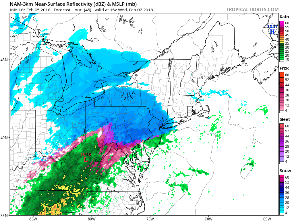
Here’s a radar snapshot for 10 AM Wednesday – we see snow just starting to move into the state, and the mix line is still down by Philadelphia.
We’ve got a classic “SWFE” on tap for Wednesday which should bring the entire state a round of wintry weather. A SWFE, or a South West Flow Event, is when you have a storm coming up from our west and passing the midlevel centers over us as opposed to a more traditional coastal storm where the midlevels are to our southeast. They often feature quite a bit of mixed precipitation as the midlevels warm while cold air damming remains locked in at the surface, and can bring a fairly uniform thump of snow to a large area to the north of the pivot point where the low stops moving north and begins to be pushed eastward towards the coast. Sometimes, that’s over us, but more often (including in this event) it will be a bit further north and deliver warning level snows to northern New England. They’re usually a relatively straightforward forecast, but sometimes have some tricks up their sleeves as cold air hangs on longer than forecast. Let’s break this one down.
Models and Trends
Believe it or not, model guidance is in very good agreement for this system. All guidance agrees that warm air advection will cause snow to break out across the state Wednesday morning, then warming in the midlevels will cause a changeover to sleet and freezing rain from south to north. On the shoreline, the surface will quickly warm enough for a cold rain, but inland, we will see sleet/freezing rain persist for some time and that could result in some ice accretions in portions of the state before we finally warm enough to see rain everywhere with the possible exception of the northwest corner of the state.
While the models have wobbled back and forth a bit with the placement of the surface and midlevel pressure centers and thus the advancing of warmer air, overall there really hasn’t been any discernable trend with this. Generally, SWFE’s tend to tick a little bit NW in the final day or so leading up to go time but also tend to verify a bit colder than modeled. As such, essentially went with a model consensus for this forecast – we can take another look tomorrow and revisit if needed, but this one looks pretty stable for now.
Let’s quickly walk through the progression of the system – this is from the 3km NAM but the idea is similar on all models.
Here’s a radar snapshot for 10 AM Wednesday – we see snow just starting to move into the state, and the mix line is still down by Philadelphia.
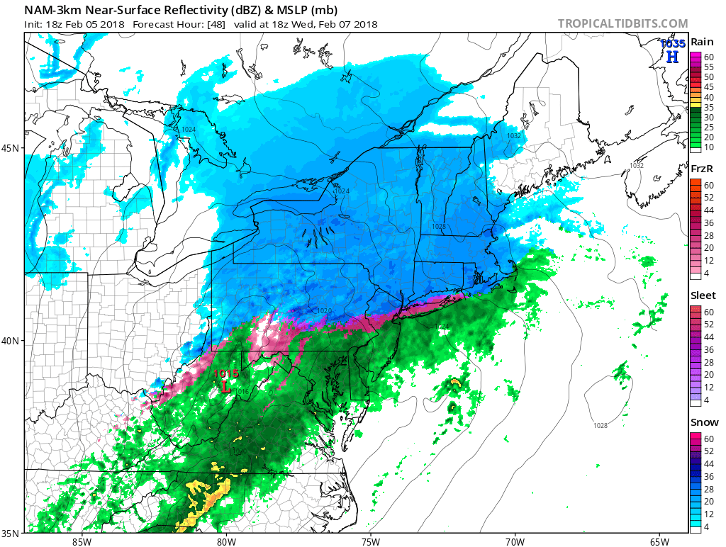
Move forward a few hours to 1 PM – we’ve got moderate snow over most of the state, but the mix line is rapidly approaching – won’t be too much longer until we see some sleet pinging on the coastline.
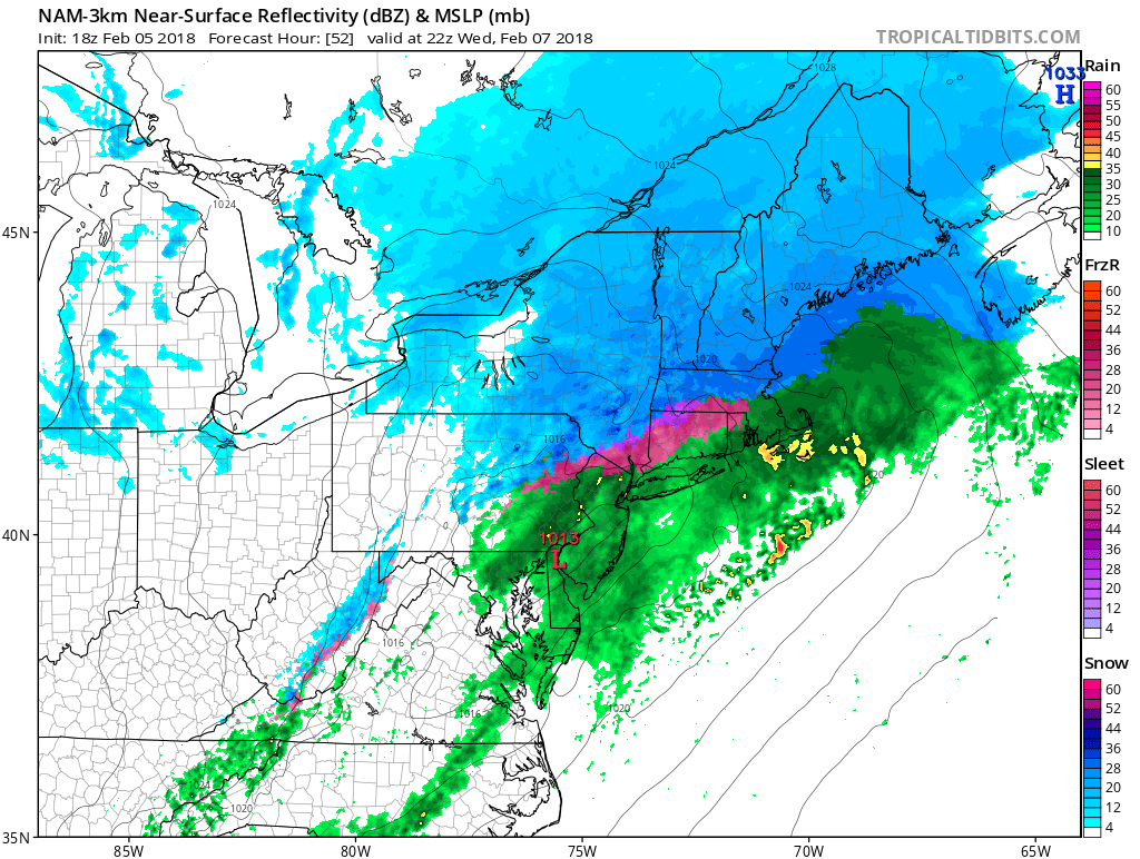
A few more hours forward brings us to 5 PM – the coastline has warmed enough that we’re mostly rain there, but inland it’s now a messy mix of sleet and freezing rain, with snow hanging on in the far northwest corner. Just perfect for your evening commute – don’t get fooled into thinking the day will be okay when you don't see snow in the morning because the evening commute on Wednesday is going to be messy.
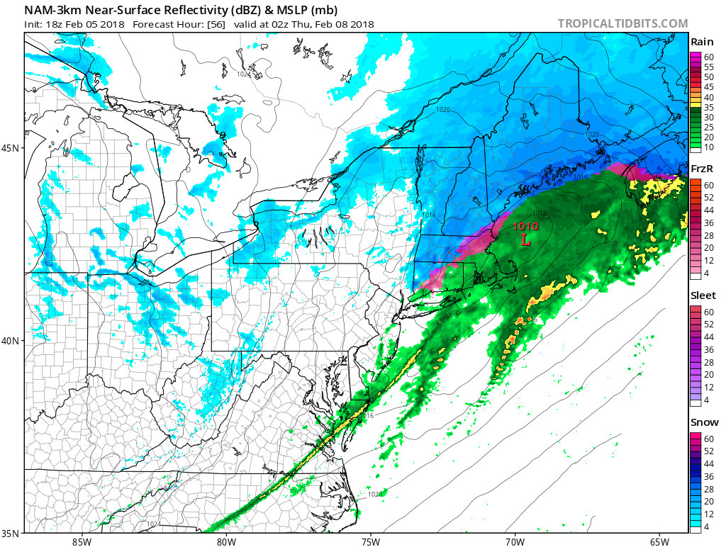
Finally we come to 9 PM – the storm is starting to pull away to our northeast, but as cold air rushes in behind the system we could see a changeover back to snow to end the event; the best chance for that will be in the northeast and northwest hills.
Forecast and Timing
Here’s our forecast snowmap for this event.
Here’s our forecast snowmap for this event.
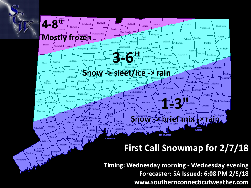
This system has a strong gulf connection and is bringing some good moisture with it, so QPF will be healthy; somewhere between half an inch and an inch is likely for most of the state. If all of that were snow, we’d be looking at a warning level event for the entire state, but as we just saw above we will lose quite a bit of that QPF to mixing and rain.
For the start of the event, we should see snow across most of the state for the first few hours, at a half an inch to an inch per hour we’re into the 1-3” range for the whole state by the early afternoon. While we’ll see southern areas quickly change to rain, northern areas should stay snow for at least a little while longer, boosting them into the 3-6” range, while in the far NW corner of the state the changeover will be delayed if it even occurs at all, so I’m going with 4-8” there to account for a bit of mixing at the end.
Icing will also be a factor, especially in the northern two zones. While the midlevel’s will likely warm above freezing, strong cold air damming at the surface will not give way easily and therefore a period of sleet and freezing rain is likely for much of the interior and possibly down the CT river valley towards New Haven as well. Some minor to moderate ice accretions are likely.
As far as timing goes, expect snow to start break out in SWCT towards the tail end of the morning commute, with snow across the whole state by late morning. The changeover to mixed precipitation should begin after lunchtime and last through most of the afternoon, with most of the state over to mixed precipitation or rain by the evening commute. Cold front passes through late in the evening and flips any remaining precipitation back to snow and the whole system is gone by midnight.
Impacts
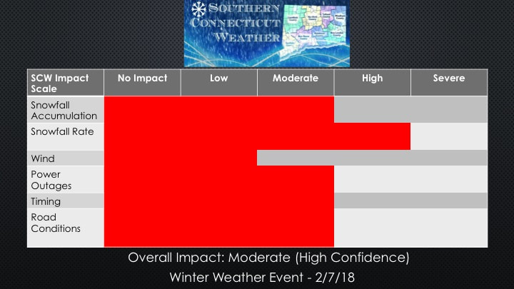
Here’s the SCW impact scale for this event. A Winter Storm Watch is in effect from the NWS for Litchfield and Hartford counties.
For the start of the event, we should see snow across most of the state for the first few hours, at a half an inch to an inch per hour we’re into the 1-3” range for the whole state by the early afternoon. While we’ll see southern areas quickly change to rain, northern areas should stay snow for at least a little while longer, boosting them into the 3-6” range, while in the far NW corner of the state the changeover will be delayed if it even occurs at all, so I’m going with 4-8” there to account for a bit of mixing at the end.
Icing will also be a factor, especially in the northern two zones. While the midlevel’s will likely warm above freezing, strong cold air damming at the surface will not give way easily and therefore a period of sleet and freezing rain is likely for much of the interior and possibly down the CT river valley towards New Haven as well. Some minor to moderate ice accretions are likely.
As far as timing goes, expect snow to start break out in SWCT towards the tail end of the morning commute, with snow across the whole state by late morning. The changeover to mixed precipitation should begin after lunchtime and last through most of the afternoon, with most of the state over to mixed precipitation or rain by the evening commute. Cold front passes through late in the evening and flips any remaining precipitation back to snow and the whole system is gone by midnight.
Impacts
Here’s the SCW impact scale for this event. A Winter Storm Watch is in effect from the NWS for Litchfield and Hartford counties.
I think we’ll see some school closings but also wouldn’t be surprised to see some districts try to push it and have at least a half day – not sure if that’s the best decision, but midday starts can be tricky – damned if you do and damned if you don’t type of situation.
Finally – it’s national Weatherperson’s Day today, so a shout out to all those in the field is in order! Thank you for all that you do to keep our profession on the leading edge of technology and accuracy while continually striving to serve the public in the best way possible.
We’ll be back tomorrow night with a final call, until then, ask us any questions you may have on our Facebook page and follow us on Twitter @SouthernCTWX. Thanks for reading SCW!
-SA
