Good evening from SCW.
While we’ve had some nice weather recently, that’s going to be pit on hold for a little while as a rainy pattern sets us up for several storms over the next week. While there will be some diamonds in the rough, the overall theme will be wet, but thankfully it doesn’t look like any late season snowstorms are in the cards.
Friday-Saturday
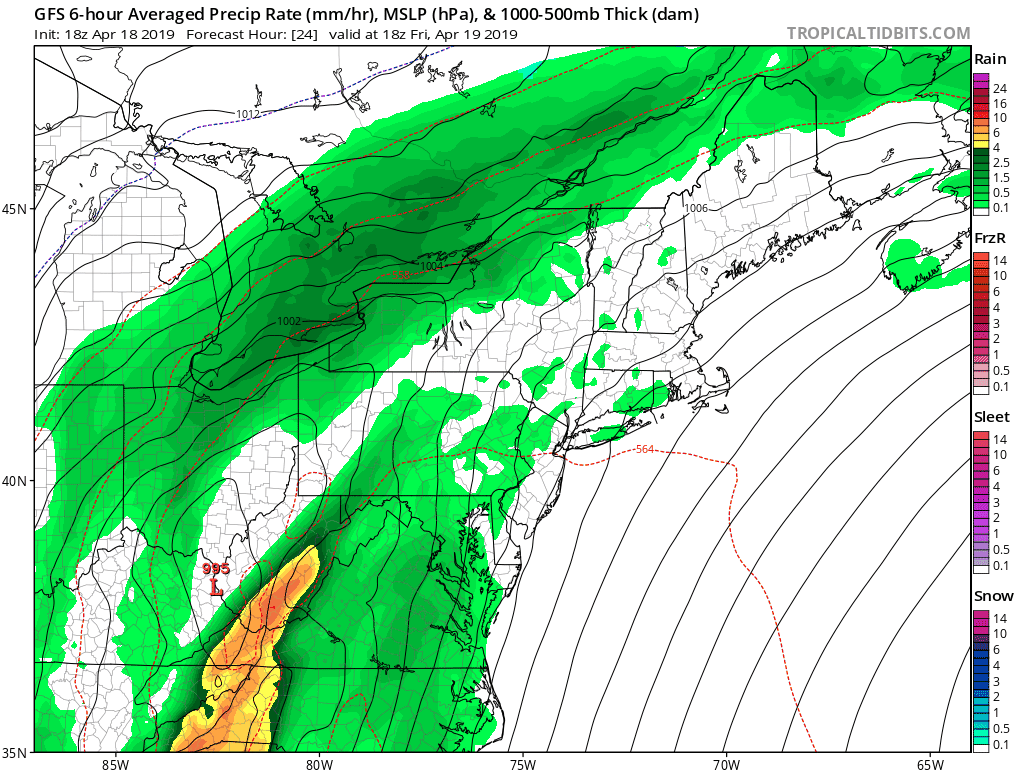
The first of several wet systems in the pipeline is currently elongated out along a warm front to our west and south; over the course of tomorrow it will slowly push east and bring some light rain to the region. While moisture levels will increase to near record levels during the day tomorrow, we will expect a chance for lighter rain throughout the day until better dynamics develop during the evening and the chance for heavier rain increases. Rain continues through Saturday as the warm front passes overhead and it is here where the best chance of some quick downpours will be found. Current high-res guidance favors western portions of the state right now for the most QPF, but we’re still a little ways out so expect some wobbles in the positioning of the warm front as we get closer. Rain moves out late Saturday, but some lingering showers could persist into the overnight hours.
Total QPF looks to be in the 1-1.5” range, but any areas that see persistent heavier precipitation will get noticeably more. Given the high levels of snowmelt to our north and the recent precipitation, rivers are quite full and so some minor flooding is to be expected, but nothing too significant should occur. More notable will be our first taste of elevated dewpoints this warm season as tropical moisture streams northward along the warm front. Overnight lows Friday night will only drop to the upper 50s to lower 60s, and with humidity near 100%, it’ll be the first “muggy” night of the season (although in July we’d probably think it’s pleasant ? ). Highs Friday and Saturday will be in the 60s, maybe lower 70s in some spots on Friday depending on how long it takes rain to move in.
Here's a look at the system on the GFS.
While we’ve had some nice weather recently, that’s going to be pit on hold for a little while as a rainy pattern sets us up for several storms over the next week. While there will be some diamonds in the rough, the overall theme will be wet, but thankfully it doesn’t look like any late season snowstorms are in the cards.
Friday-Saturday
The first of several wet systems in the pipeline is currently elongated out along a warm front to our west and south; over the course of tomorrow it will slowly push east and bring some light rain to the region. While moisture levels will increase to near record levels during the day tomorrow, we will expect a chance for lighter rain throughout the day until better dynamics develop during the evening and the chance for heavier rain increases. Rain continues through Saturday as the warm front passes overhead and it is here where the best chance of some quick downpours will be found. Current high-res guidance favors western portions of the state right now for the most QPF, but we’re still a little ways out so expect some wobbles in the positioning of the warm front as we get closer. Rain moves out late Saturday, but some lingering showers could persist into the overnight hours.
Total QPF looks to be in the 1-1.5” range, but any areas that see persistent heavier precipitation will get noticeably more. Given the high levels of snowmelt to our north and the recent precipitation, rivers are quite full and so some minor flooding is to be expected, but nothing too significant should occur. More notable will be our first taste of elevated dewpoints this warm season as tropical moisture streams northward along the warm front. Overnight lows Friday night will only drop to the upper 50s to lower 60s, and with humidity near 100%, it’ll be the first “muggy” night of the season (although in July we’d probably think it’s pleasant ? ). Highs Friday and Saturday will be in the 60s, maybe lower 70s in some spots on Friday depending on how long it takes rain to move in.
Here's a look at the system on the GFS.
Sunday-Tuesday
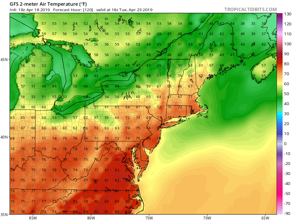
Weak cold front moves in Saturday night to cut off the heavier precipitation, but lingering showers could last into Sunday. Guidance shows another weak system moving in to start the workweek which could bring more rain Monday into Tuesday, although this one will likely be more scattered in nature. Given that there is little run to run consensus on what this looks like, will carry chance pops for showers through the period, but not expecting a total washout for all three days. What happens with temps will ultimately depend on how that system tracks, should we be on the warm side, widespread 70s are possible, whereas if we’re on the cool side we’ll likely rot in the 50s with rain. Will carry a compromise in the 60s for now, but stay tuned.
Here's a look at the forecast highs for Tuesday from the GFS. If we can hold off the rain it'll be quite nice, that said the wetter solutions are also the cooler ones so confidence in readings making it that high is quite low.
Wednesday-Thursday
Brief high pressure crosses the area between systems before yet another rainmaker lines up towards the end of the week. This one looks like an even weaker front at the moment on the models, but given how far out it is there’s still plenty of time for that to change. Will carry chance pops for Thursday for now. Highs on Wednesday look like 60s to maybe lower 70s along the coast, but cooling off for Thursday as the next front moves in.
The Dailies
Friday: A chance of showers in the morning, then showers likely in the afternoon. Highs in the upper 60s to lower 70s. Chance of precipitation is 80%.
Saturday: Rain. Highs in the mid 60s. Chance of precipitation is 100%.
Sunday: A chance of showers, otherwise, partly cloudy, with highs in the low to mid 60s. Chance of precipitation is 40.
Monday: A chance of showers, otherwise, partly cloudy, with highs in the upper 50s to mid 60s. Chance of precipitation is 40%
Tuesday: A chance of showers, otherwise, partly cloudy, with highs in the lower 60s to mid 60s. Chance of precipitation is 50%
Wednesday: Partly sunny, with highs in the upper 60s to lower 70s.
Thursday: A chance of showers, otherwise, partly cloudy, with highs in the mid to upper 60s. Chance of precipitation is 30%.
Overall a wet forecast, but after Saturday not a washout and I do think we’ll see the sun poke through at times even on those partly cloudy days. Have a great weekend and thank you for reading SCW!
-SA
