Forecasters Discussion for 4/4/18
Good evening from Southern Connecticut Weather!
Hope you all enjoyed the seasonal weather we had today since it looks like we are going to take a dive back into some colder weather this weekend! Models are predicting a stormy pattern for us over the next week, and dare I say it, the possibility of snow Friday and Saturday. The good thing is it isn’t anything too big to worry about, but I know how we all feel about seeing the word “snow” after the winter we just had. In this forecast we will talk about the two systems we are watching for this weekend, and how they will impact the state for this weekend.
Thursday
The upper level energy that brought us rain today tracks out to the Atlantic, and behind it a weak ridge builds in Thursday. This will bring sub-seasonal temperatures in the low 40s across the state, but at the same time keep the skies nice and sunny. Winds will start off strong and calm down by Thursday night, as an upper level shortwave approaches from the Great Lakes.
Friday
Our first system that moves through will be the shortwave energy, and with temperatures below freezing for the early part of the day, we will expect the precip to be snow at first. Given this will be very light snow, statewide little to no accumulation is expected. By late afternoon, the onshore flow associated with the low will warm the air, and a switch to light rain is expected. Overcast conditions Friday night will lead us into the system we have been watching for the weekend.
Saturday
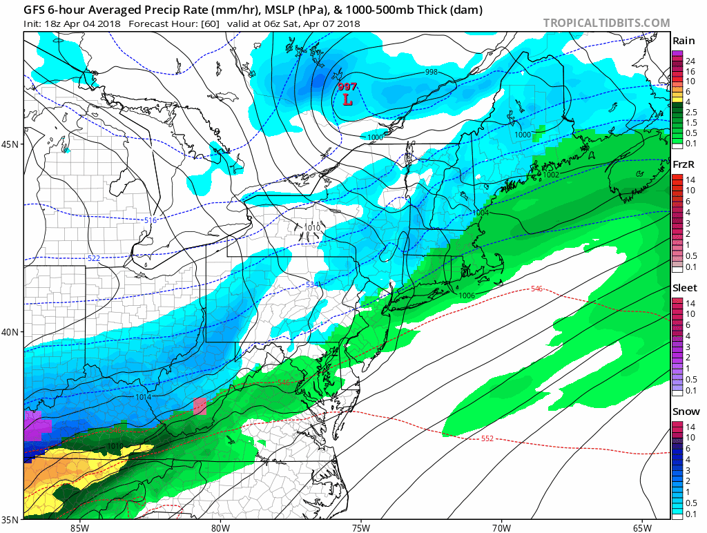
Models show a system developing over the Southeast US from the phasing of an upper level trough and weak energy over the Southeast. Consensus is that the precip will start Saturday morning as rain for most of the state before changing to snow, and end late Saturday night. Right now, the models can’t pinpoint the exact track of the precipitation shield, which would determine the intensity and amount of precipitation we will receive. Latest GFS and Euro models put the system further South than the NAM and Canadian models. Dry air to our north will play a factor in how far north the system will track, and also what type of precip we are to expect.
The current GFS run looks like this:
Good evening from Southern Connecticut Weather!
Hope you all enjoyed the seasonal weather we had today since it looks like we are going to take a dive back into some colder weather this weekend! Models are predicting a stormy pattern for us over the next week, and dare I say it, the possibility of snow Friday and Saturday. The good thing is it isn’t anything too big to worry about, but I know how we all feel about seeing the word “snow” after the winter we just had. In this forecast we will talk about the two systems we are watching for this weekend, and how they will impact the state for this weekend.
Thursday
The upper level energy that brought us rain today tracks out to the Atlantic, and behind it a weak ridge builds in Thursday. This will bring sub-seasonal temperatures in the low 40s across the state, but at the same time keep the skies nice and sunny. Winds will start off strong and calm down by Thursday night, as an upper level shortwave approaches from the Great Lakes.
Friday
Our first system that moves through will be the shortwave energy, and with temperatures below freezing for the early part of the day, we will expect the precip to be snow at first. Given this will be very light snow, statewide little to no accumulation is expected. By late afternoon, the onshore flow associated with the low will warm the air, and a switch to light rain is expected. Overcast conditions Friday night will lead us into the system we have been watching for the weekend.
Saturday
Models show a system developing over the Southeast US from the phasing of an upper level trough and weak energy over the Southeast. Consensus is that the precip will start Saturday morning as rain for most of the state before changing to snow, and end late Saturday night. Right now, the models can’t pinpoint the exact track of the precipitation shield, which would determine the intensity and amount of precipitation we will receive. Latest GFS and Euro models put the system further South than the NAM and Canadian models. Dry air to our north will play a factor in how far north the system will track, and also what type of precip we are to expect.
The current GFS run looks like this:
And the current NAM run looks like this:
Latest qpf forecasts show 0.1”-0.25” across the state. Atmospheric soundings suggest this will be a wet snow, and 10:1 ratio would be bullish for a storm this late in the season. Given the qpf and a snowfall ratio of about 7:1 or 8:1, this would put out about 1-2 inches of snow. The issues we have with this storm is that warm temperatures may linger over the surface, and given the time of year it is and the type of system, it doesn’t look too supportive of significant snowfall. That said, should a NAM like solution verify, we would see much more impactful totals, so we will continue to monitor this system and provide you updates as we learn more information about it.
Sunday-Monday
Weak high pressure moves in behind our system. A few breaks of sun as temperature look to climb into the 40s for both days.
Tuesday-Wednesday
Another shortwave from the Great Lakes moves through and this time will bring cold rain for most of the day Tuesday, with temperatures in the low 40s statewide.
The Dailies:
Thursday: Mostly sunny with highs in the low 40s.
Friday: Snow showers in the afternoon changing over to light rain by the evening. Highs in the upper 30s. Little to no accumulation expected.
Saturday: Rain in the morning changing over to snow by the afternoon, and ending by nighttime. Chance of precipitation is 60%. C-2” of wet snow possible.
Sunday: Mostly sunny, highs in the 40s.
Monday: Mostly cloudy, highs in the 40s.
Tuesday: Rain. Highs in the low 40s.
Wednesday: Rain ending early. Highs in the mid 40s.
Thank you for reading SCW!
- LD
