Good afternoon to you from Southern Connecticut Weather!
Interesting forecast this evening as we look at an area of low pressure moving up the eastern seaboard along the cold front that will arrive overnight, finally ending the heatwave that we’ve been experiencing for the past week. Guidance remains in good agreement on a narrow band of heavy rain developing just to the north of the low center along the front, but as is usual, small details in the placement of the system make a significant difference as to where this band of rain ultimately ends up. In addition, guidance signals the potential for a convective band of thunderstorms tomorrow morning, along with the ingredients for potential tornadoes.
Let’s start with the placement of the surface low. Models generally track the system just south of or directly over Long Island, with the band of heavier precipitation setting up just to the north of the low center on the boundary between the warm and cold sectors of the system. With high precipitable water values and a strong jet, wherever this band does set up will likely see quite a bit of rain, with values of >2” possible where the strongest downpours set up.
The question, of course, is where those downpours will set up. Let’s take a look at the guidance.
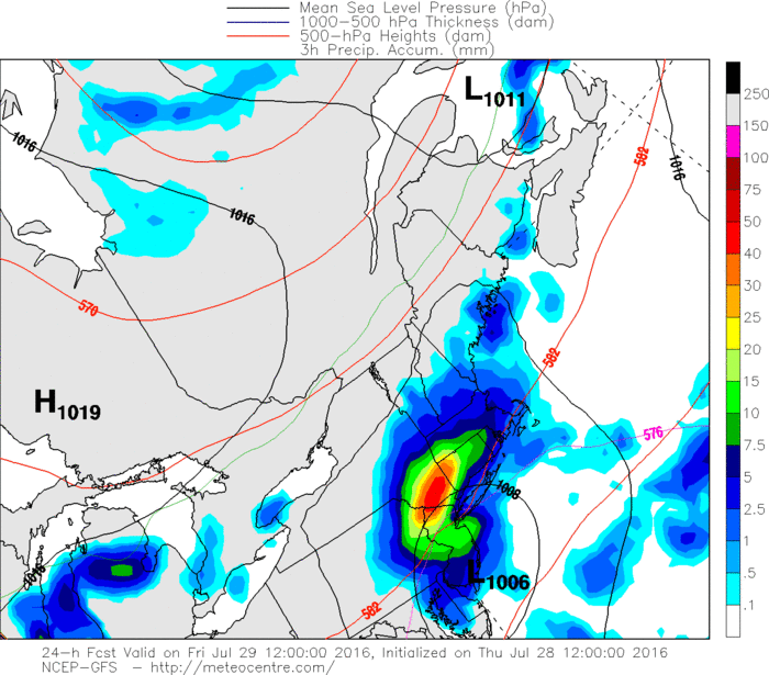
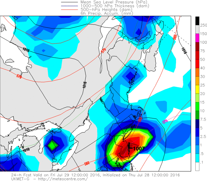
Above are images from the GFS and UKMET for 8 AM tomorrow morning. The difference in the low placement is clear; the slightly further south placement on the UKMET means that the heavier rains largely miss the area, while the GFS trains the heavier rains right over the state. The midday guidance generally shifted south a little bit from the overnight runs, and considering that most rain events this summer have shifted south at the last minute (leaving us out of them), I’m inclined to lean a bit more towards the southern solutions. However, I do expect some rain across the state, with the heaviest along the south coast and in the southwest corner, where some enhancement is likely and very heavy rates are possible. Keep in mind that should a solution closer to the GFS verify, tomorrow will be quite rainy for all in the state, so definitely don’t make any outdoor plans if you don’t want to get wet! The heaviest rains should be in the morning into early afternoon, with the system moving out later in the day leaving some scattered showers behind through the evening.
Now let’s take a look at the convective part of the system. Instability along the warm front advocates for a band of thunderstorms to set up just north of the system, likely over Long Island or the south coast of CT. My concern with these storms is that low-level shearing will be enhanced with such a strong warm front, which, combined with the instability present from the system, could lead to a possible tornado. While it is nowhere near likely, it is not at all out of the question. As such, SPC has placed the immediate coastline in a Marginal Risk for severe weather tomorrow. Any severe threat would be in the morning; from sunrise until noontime or so.
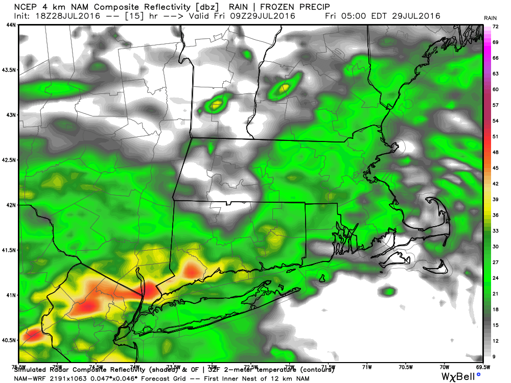
Here’s an example of what this may look like tomorrow morning, taken from the hi-res NAM model for 5 AM tomorrow. You can see the enhanced cells in southwest CT into Westchester and northern NJ.
Now let’s take a look at the convective part of the system. Instability along the warm front advocates for a band of thunderstorms to set up just north of the system, likely over Long Island or the south coast of CT. My concern with these storms is that low-level shearing will be enhanced with such a strong warm front, which, combined with the instability present from the system, could lead to a possible tornado. While it is nowhere near likely, it is not at all out of the question. As such, SPC has placed the immediate coastline in a Marginal Risk for severe weather tomorrow. Any severe threat would be in the morning; from sunrise until noontime or so.
Here’s an example of what this may look like tomorrow morning, taken from the hi-res NAM model for 5 AM tomorrow. You can see the enhanced cells in southwest CT into Westchester and northern NJ.
To sum it up; expect rain tomorrow morning through mid afternoon, with the best chance for heavy downpours and possible flooding in the southern portion of the state. Some thunderstorms are possible as well, especially along the coastline where there is an isolated chance of some severe weather. The NWS has issued Flash Flood Watches for the entire state.
Behind this system, Saturday looks to be a beautiful day to be outside, with temps in the mid 80s and nearly full sunshine. Showers and thunderstorms return from Saturday evening through Monday as another shortwave passes over the area. Mostly calm weather then follows to start off the workweek, although some typical afternoon storms will be possible.
Here are the dailies:
Friday: Rain, heavy at times, best chance for heavy rain in southern portions of the state. Some thunderstorms are also possible. Otherwise, cloudy, with highs in the low 80s. Chance of precipitation is 80%
Saturday: Mostly sunny, with highs in the mid 80s.
Sunday: A chance of showers and thunderstorms, otherwise, mostly cloudy, with highs in the upper 70s to lower 80s. Chance of precipitation is 50%.
Monday: A chance of showers and thunderstorms, otherwise, partly cloudy, with highs in the lower 80s. Chance of precipitation is 40%.
Tuesday: Mostly sunny, with highs in the low to mid 80s.
Wednesday: Mostly sunny, with highs in the low to mid 80s.
Thursday: Mostly sunny, with highs in the mid to upper 80s.
Stay dry tomorrow, have a wonderful weekend, and thank you for reading SCW!
-SA
