Good afternoon from Southern Connecticut Weather,
This week, we’ll be dealing with a bit of a roller coaster ride in terms of sensible weather. Today, we’re dealing with seasonably cool conditions with the potential of some light freezing rain in spots. Tomorrow we warm up for a bit, and by Thursday we are watching the growing potential for what I think is our first nor’easter of the season. This’ll be a brief post covering the next few days.
Today
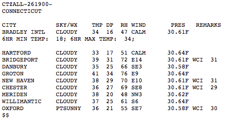
Temperatures are holding near freezing across much of northern Connecticut, and with precipitation approaching from the west, the National Weather Service has freezing rain advisories up for Litchfield and Hartford Counties from 3pm to 11pm in Hartford County and 1 to 10 in Litchfield. Looking at afternoon temperatures, I think this is a nonevent for most. However, it only takes a little bit of ice to cause significant problems, so use extra caution out on the roads. As temperatures warm more this afternoon, the freezing rain/drizzle threat diminishes.
This week, we’ll be dealing with a bit of a roller coaster ride in terms of sensible weather. Today, we’re dealing with seasonably cool conditions with the potential of some light freezing rain in spots. Tomorrow we warm up for a bit, and by Thursday we are watching the growing potential for what I think is our first nor’easter of the season. This’ll be a brief post covering the next few days.
Today
Temperatures are holding near freezing across much of northern Connecticut, and with precipitation approaching from the west, the National Weather Service has freezing rain advisories up for Litchfield and Hartford Counties from 3pm to 11pm in Hartford County and 1 to 10 in Litchfield. Looking at afternoon temperatures, I think this is a nonevent for most. However, it only takes a little bit of ice to cause significant problems, so use extra caution out on the roads. As temperatures warm more this afternoon, the freezing rain/drizzle threat diminishes.
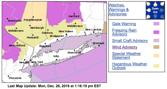
Current advisories and temperatures across Connecticut as of 1pm.
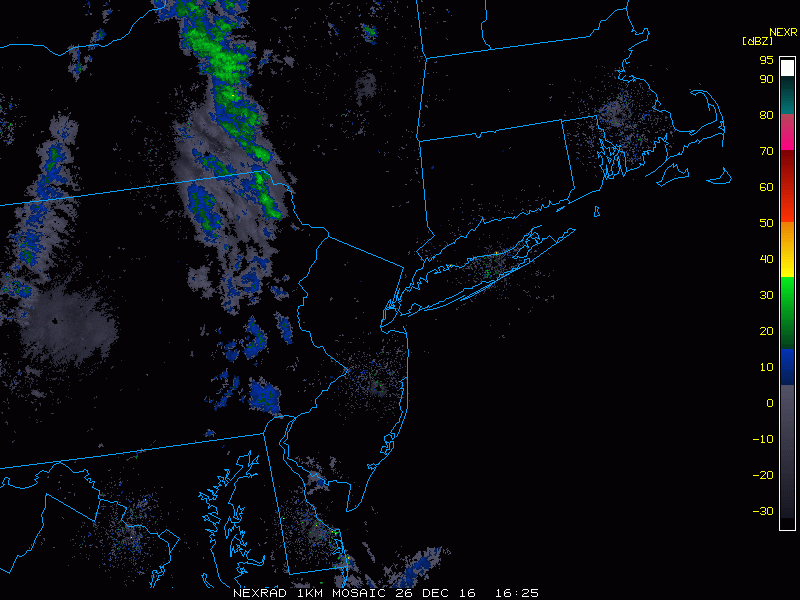
The latest radar image showing precipitation pushing toward the state. I expect off and on showers through the state during much of the day and evening, with freezing rain/drizzle in some of our coldest spots.
Wednesday should be a nice and (mostly) warm day, with temperatures pushing the 50s very early in the morning and dropping temperatures through the day as we get another shot of cooler weather moving in. This sets the stage for Thursday.
Thursday
So far this season, the pattern has been most conducive for cutters—storms that develop and cut to our west, bringing periods of mixed precipitation because of marginal airmasses in place that quickly turn to rain as the mid level and surface temperatures warm off a southerly wind.
When you hear the term nor’easter, you most likely think of “cold powder” snowstorms, with temperatures more than cold enough for snow all the way to the shore (except southeastern Connecticut, sorry folks), however, not all nor’easters are pure snowstorms, and the coming event looks to be the same at this time.
Although we’re talking about the Thursday timeframe, there is enough uncertainty to hold off on doing a map and going into great detail. Here is what we know right now:
The setup is fairly simple. An area of low pressure will traverse across Canada as a shortwave drops from the Great Lakes region and develops rapidly off the coast. The faster and further south the low develops the better for snow chances. In the last few model suites, the trend has been toward colder and more snow for our part of the world. That said, every model has a mix of rain and snow, as marginal temperatures and a lack of locked in cold (due to a lack of a high in eastern Canada) makes it hard for us to keep it cold enough for an all snow event. In addition, there are questions over the eventual track of the low, which has an impact on what we eventually end up with.
Thursday
So far this season, the pattern has been most conducive for cutters—storms that develop and cut to our west, bringing periods of mixed precipitation because of marginal airmasses in place that quickly turn to rain as the mid level and surface temperatures warm off a southerly wind.
When you hear the term nor’easter, you most likely think of “cold powder” snowstorms, with temperatures more than cold enough for snow all the way to the shore (except southeastern Connecticut, sorry folks), however, not all nor’easters are pure snowstorms, and the coming event looks to be the same at this time.
Although we’re talking about the Thursday timeframe, there is enough uncertainty to hold off on doing a map and going into great detail. Here is what we know right now:
- The chances have increased for the development of a nor’easter during the Thursday-early Friday timeframe.
- The lack of a deep cold source and blocking and potential track of this coastal storm make it unlikely for this to be an all snow event.
- Currently we expect a mix of rain and snow, with the potential for significant snowfall accumulations in the northern tier of Connecticut.
The setup is fairly simple. An area of low pressure will traverse across Canada as a shortwave drops from the Great Lakes region and develops rapidly off the coast. The faster and further south the low develops the better for snow chances. In the last few model suites, the trend has been toward colder and more snow for our part of the world. That said, every model has a mix of rain and snow, as marginal temperatures and a lack of locked in cold (due to a lack of a high in eastern Canada) makes it hard for us to keep it cold enough for an all snow event. In addition, there are questions over the eventual track of the low, which has an impact on what we eventually end up with.
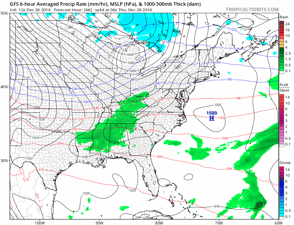
Latest GFS depiction, showing a rapidly intensifying low pressure of the New England coast, but with temperatures marginal and no cold locked in place, there isn't a mechanism to keep this an all snow event--at least based on the current depiction.
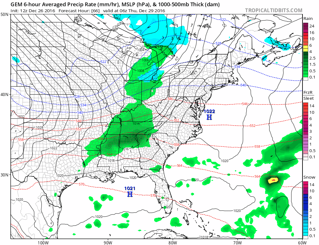
Here is the Canadian model depiction of the surface over the next few days. Similar to the GFS, but is a bit colder which results in more snowfall in northern Connecticut. Of course, this will change over the next few days so do not take this verbatim.
What you cannot see here is the European model, which has been trending colder tick by tick recently. To be clear, that doesn’t mean that a trend cannot reverse, but the euro trending colder is a red flag for the potential for a more impactful event away from the coast. Overall, I have moderate confidence in a moderate to significant precipitation event in Connecticut on Thursday, with low but growing confidence in accumulating snow in northern Connecticut. This will change as we get closer to the event, so stay tuned for additional updates.
Please like us on Facebook and follow us on Twitter @SouthernCTWX, share, and ask questions as always. Thank you for reading SCW.
-DB
Please like us on Facebook and follow us on Twitter @SouthernCTWX, share, and ask questions as always. Thank you for reading SCW.
-DB
