Good evening from Southern Connecticut Weather.
Hurricane Lee is one of the classic "long track" storms we haven't seen in quite some time. As a result, there has been an abundance of time for the hype machine on social media to rev up.
Let's take a fact-based look at Hurricane Lee, the potential scenarios, and possible impact on CT this coming weekend.
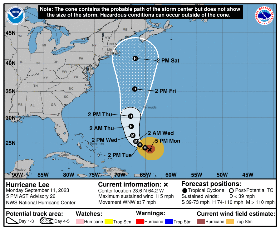
Above: the current National Hurricane Center (NHC) forecast track. The NHC track only goes out five days, and as you can see, the projected center line is not forecast to be over NYC, Boston, or any part of CT at 2pm on Saturday. This is consistent with the overwhelming majority of track guidance.
Where is Lee Now and What is the Short Term Forecast?
Hurricane Lee is currently a major hurricane well north of Puerto Rico, moving west-northwest at a slow 7 mph. Lee is expected to slow down even more, as it rounds the periphery of a ridge of high pressure over the Atlantic. It is rounding the ridge because a trough is causing a weakness that will allow for Lee to turn northward by late Wednesday or early Thursday.

Above: 18z GFS operational run out through hour 78, courtesy of Tropical Tidbits. Lee turns northwest and then northward in the next few days, west of Bermuda. This is a high confidence forecast, and I am using the operational of the GFS here because 1) it has a nearly identical depiction to other guidance and 2) it is a short term forecast.
Guidance begins to split in agreement after roughly passing the latitude of Bermuda.
A hurricane turning north this far east would almost always get swept out to sea by the trough (blue shading and lowering heights) over the eastern US. Normally, for a direct CT or southern New England landfall threat, a hurricane reaches the Bahamas before turning north.
However, in this instance the guidance also agrees that the original trough above moves out before sweeping Lee harmlessly out to sea. That allows for the Atlantic ridge to build back in to the north of Lee, effectively blocking that out to sea path.
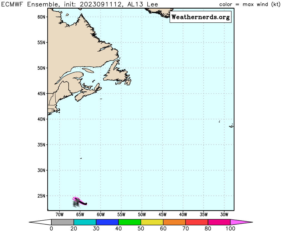
As that happens, a second trough sweeps in from the eastern US, which forces Lee to take an extended northward, or critical to New England, possible north-northwest heading before eventually getting shunted east. Below are the 12z EPS and GEFS (ensemble) runs. These images are courtesy of Weathernerds.com.
Guidance begins to split in agreement after roughly passing the latitude of Bermuda.
A hurricane turning north this far east would almost always get swept out to sea by the trough (blue shading and lowering heights) over the eastern US. Normally, for a direct CT or southern New England landfall threat, a hurricane reaches the Bahamas before turning north.
However, in this instance the guidance also agrees that the original trough above moves out before sweeping Lee harmlessly out to sea. That allows for the Atlantic ridge to build back in to the north of Lee, effectively blocking that out to sea path.
As that happens, a second trough sweeps in from the eastern US, which forces Lee to take an extended northward, or critical to New England, possible north-northwest heading before eventually getting shunted east. Below are the 12z EPS and GEFS (ensemble) runs. These images are courtesy of Weathernerds.com.
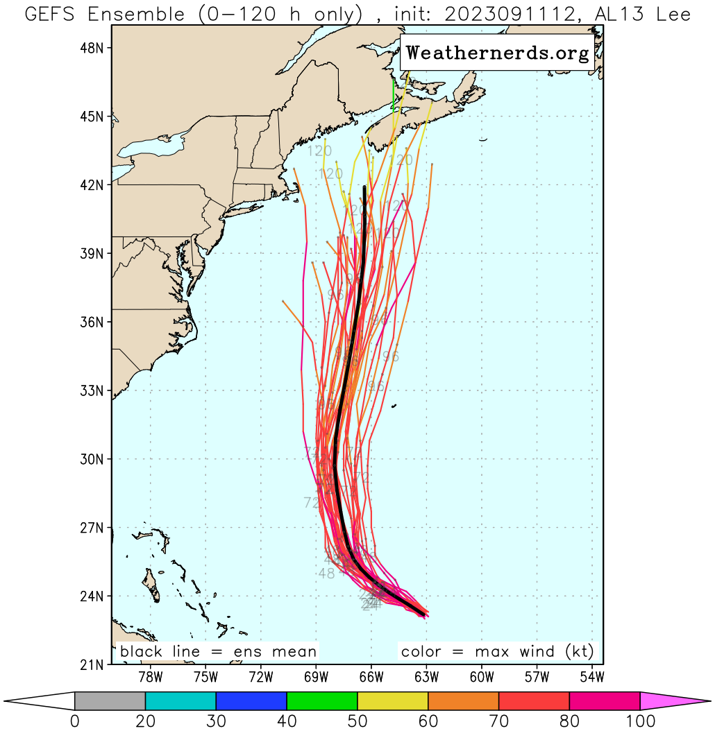
Remember that ensembles are individual runs that have environmental conditions tweaked and then aggregated to give a sense of model forecast spread. The top image is the GEFS run. The animation below it is the EPS, European ensembles.
Two things stand out.
First, the ensembles do not follow the operational runs you may have seen that bring Lee closer to eastern New England.
Second, the ensembles do not show a significant risk of a direct hit on CT from Lee.
It's important to remember that the center of a storm is not the only place where impacts happen. Lee is expected to expand quite dramatically and bring wind and rain well away from its center. However, an offshore track would significantly minimize the rain and wind hazards for CT.
What's Going to Happen From Here?
That's still unclear. We're only now reaching the point where we can start to narrow the goal posts. There is high confidence in a turn north, and high confidence in an extended northward heading. There is also high confidence that this will not be a major hurricane once it reaches New England's latitude. Why? Sea surface temperatures are expected to drop off dramatically, and this will happen as shear increases, dry air is possibly entrained into the system, and it begins merging with the incoming trough to become extratropical.
Lee will be larger, slower, and weaker, once it reaches New England's latitude. That doesn't mean weak storm, but it allows you to contextualize better.
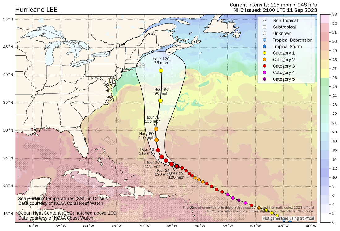
Above: the NHC track superimposed on the current sea surface temperature plot. Note how temperatures drop off rapidly once Lee gets north of the Gulf Stream in the Atlantic (north of where it says "Hour 96"). Image courtesy of Tomer Burg's phenomenal site.
It is still unclear whether we see a bend NNW toward New England, and a long enough motion on that heading to put CT at risk of significant impacts.
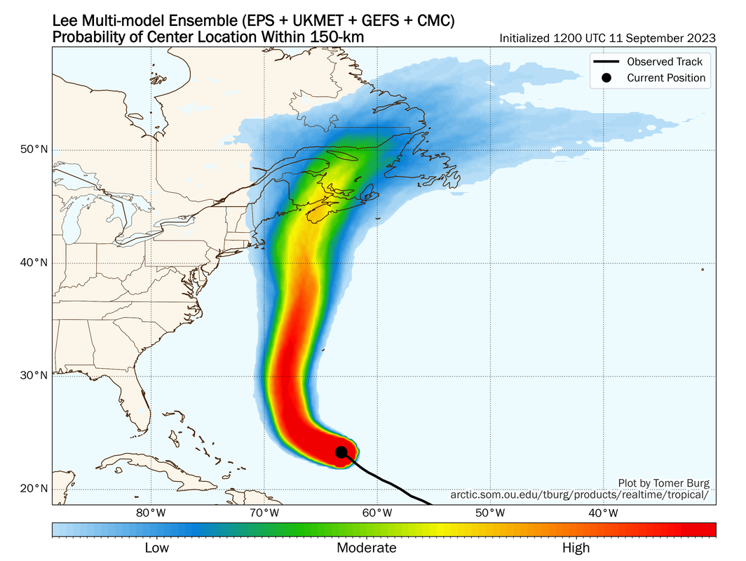
In collaborating with GP this evening, he noted that he could only find two hurricanes that made landfall in Maine (the higher risk zone should this keep north): Hurricane Edna in 1954 and Hurricane Gerda in 1969. This shows how rare this kind of track actually is. That's still reflected in the super ensemble, a collection of all the major ensembles, also found on Tomer's site.
It is still unclear whether we see a bend NNW toward New England, and a long enough motion on that heading to put CT at risk of significant impacts.
In collaborating with GP this evening, he noted that he could only find two hurricanes that made landfall in Maine (the higher risk zone should this keep north): Hurricane Edna in 1954 and Hurricane Gerda in 1969. This shows how rare this kind of track actually is. That's still reflected in the super ensemble, a collection of all the major ensembles, also found on Tomer's site.
Scenarios
With everything above, and my own analysis of the projected steering pattern, I divide up potential impacts in three scenarios.
Should I Worry?
At SCW, we preach Preparation over Panic. There is no reason to worry, and definitely no reason to panic, over the potential track of Lee. At this range, a lot can still change as we're narrowing the goal posts, because even 100 miles can make a difference in what our weather is. We won't know exact track for a few more days at least.
At this point, there are a couple of small but important steps that you can take to prepare in case this ends up more impactful. I've posted before and this advice is evergreen.
The Four Basics
1. Know Your Zone--given what I said above, it's unlikely this is a bad enough hit to require an evacuation, but know your evacuation zone in case you need to leave. In CT, that's most likely to be right at the coast, where flooding would occur. The majority of deaths caused by tropical systems are flood related--storm surge or inland flooding. You can find the evacuation maps here.
2. Make A Plan--this seems self-explanatory, but what would you do if you lost power? Needed to evacuate? Needed to get supplies? Check in on a loved one? Having a plan now will save you time and worry later.
3. Build An Emergency Kit--You don't need to make all your purchases at once, but if you wait until a day or two before a storm hits you will run into empty shelves for some items and potentially higher prices. This can be helpful even if there isn't a storm.
4. Stay Informed--Get your information from trusted sources. Don't panic or dismiss a threat just because of one model run or model cycle. Stay level headed and use quality information to make an informed decision.
Stay tuned as we continue to update this forecast in the coming days.
As always, please like, share, and interact with us on our social media--on Facebook to share our discussions, and follow us on Twitter @southernctwx to retweet our posts. Hit the buttons below to join.
Thank you for reading and trusting SCW.
-DB
With everything above, and my own analysis of the projected steering pattern, I divide up potential impacts in three scenarios.
-
Atlantic Canada Landfall (most likely Nova Scotia)--60%
- It is becoming increasingly likely that the second trough pulls Lee on an extended northward heading, and that Lee will not be able to fully escape, even if there is a last minute trend east which fits New England hurricane climatology.
- In this scenario, there are few impacts on CT. High surf and rip currents would be possible along with some minor coastal flooding, but there would likely be few if any rain showers or gusty winds--gusty enough to cause problems.
-
New England Landfall--30% (25% Eastern New England/5% Southern New England)
- Eastern New England--Cape Cod and Maine, are far more favored for a landfall or center scrape because the ensembles have not meaningfully put southern New England at risk even as they have generally shifted west until recent runs today.
- In this scenario, there are significant impacts. Obviously the southern New England scenario would be high impact, but in dealing with the more likely--a scrape of the Cape--we probably see rain and strong winds, especially in eastern CT, in addition to possible coastal flooding on Saturday.
-
Out to Sea--10%
- Respect still should be given to a sharper than anticipated eastward shift, but this looks increasingly unlikely.
Should I Worry?
At SCW, we preach Preparation over Panic. There is no reason to worry, and definitely no reason to panic, over the potential track of Lee. At this range, a lot can still change as we're narrowing the goal posts, because even 100 miles can make a difference in what our weather is. We won't know exact track for a few more days at least.
At this point, there are a couple of small but important steps that you can take to prepare in case this ends up more impactful. I've posted before and this advice is evergreen.
The Four Basics
1. Know Your Zone--given what I said above, it's unlikely this is a bad enough hit to require an evacuation, but know your evacuation zone in case you need to leave. In CT, that's most likely to be right at the coast, where flooding would occur. The majority of deaths caused by tropical systems are flood related--storm surge or inland flooding. You can find the evacuation maps here.
2. Make A Plan--this seems self-explanatory, but what would you do if you lost power? Needed to evacuate? Needed to get supplies? Check in on a loved one? Having a plan now will save you time and worry later.
3. Build An Emergency Kit--You don't need to make all your purchases at once, but if you wait until a day or two before a storm hits you will run into empty shelves for some items and potentially higher prices. This can be helpful even if there isn't a storm.
4. Stay Informed--Get your information from trusted sources. Don't panic or dismiss a threat just because of one model run or model cycle. Stay level headed and use quality information to make an informed decision.
Stay tuned as we continue to update this forecast in the coming days.
As always, please like, share, and interact with us on our social media--on Facebook to share our discussions, and follow us on Twitter @southernctwx to retweet our posts. Hit the buttons below to join.
Thank you for reading and trusting SCW.
-DB
