Good evening to you from Southern Connecticut Weather!
The past several weeks have been an incredibly boring time as far as this meteorologist is concerned. Days of missed storm systems, docile temperatures, and little precipitation leaves little to be discussed, and as such our presence on the airwaves has been less than consistent. However, just when we thought winter was over and we were preparing to wrap up the winter season and officially move to spring, the models have drawn us back in, showing a potential winter storm for late this weekend into early next week.
First, the rest of this week. The general theme of calm and warm continues throughout the rest of the week, with mostly sunny skies and comfortable temperatures. We will see a chance of some isolated thunderstorms both tomorrow and Friday, with strong winds and some small hail not out of the question should a severe storm or two develop. Otherwise, blustery conditions tomorrow and Friday give way to cooler and calmer on Saturday, but sunshine persists throughout the end of the week.
Attention then turns to a powerful system coming up the coastline that looks to hit the area late this weekend into early next week. Modeling is fairly consistent on the fact that there will be a system off the coastline in the period, however, it remains unclear how close to the coastline it will be. The deciding factors are twofold; first, an upper level ridge to the west of us that guides the storm across the country, and secondly, a 50/50 low to our northeast which will provide a block and, as modeled now, keep the storm from cutting to our west as so many systems have done this year. Where these features end up being placed will determine the path which the storm takes up the coastline, and the eventual impact to our area.
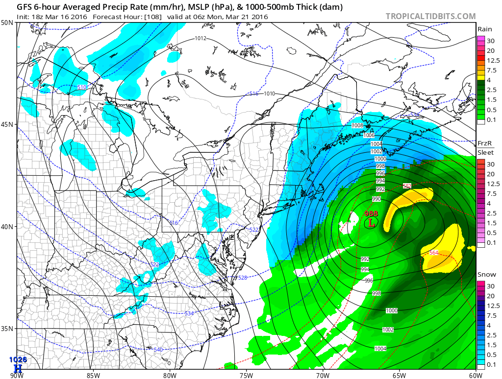
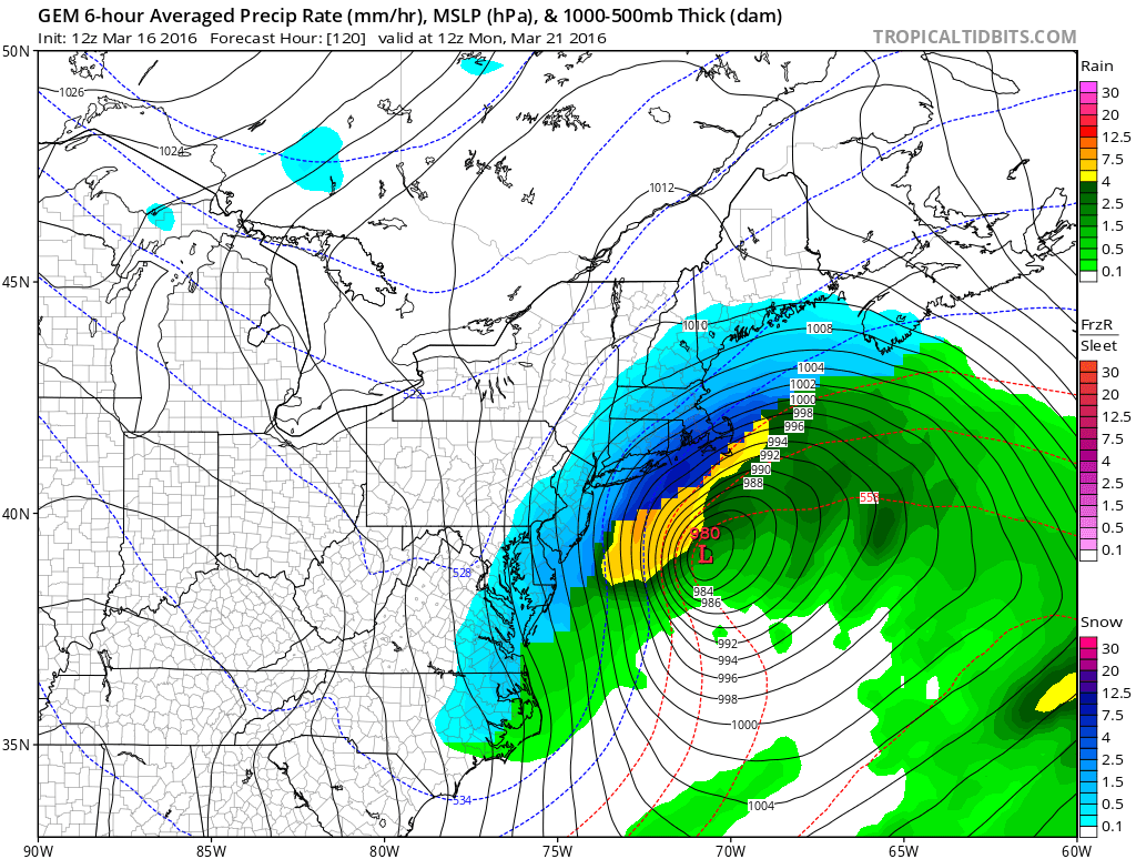
The modeling is split into three camps, as is often the case with coastal storms. The first, the GFS, passes the system outside of the 40/70 benchmark and as a result delivers a light event to the eastern portion of the state with little to nothing in the western portion of the state. The middle camp, consisting of the GGEM and Euro, brings the system right over the 40/70 benchmark, which results in a significant snowstorm across the state. And the final camp, consisting of the ensembles of the Euro, brings the system over Cape Cod, resulting in snow to rain for most of the state with the most significant snowfall being in the northwest corner of the state.
Which solution verifies remains up in the air for now, however, it should be noted that the seasonal trend this winter has been for systems to come further west as we approach verification, which lends a bit more support for some sort of hit, whether that is rain or snow is still to be determined. It’s also important to note that unlike our other phantom snow threats, this one has a much more favorable upper air setup, with the aforementioned 50/50 low and a –NAO providing blocking to our north and the ridge to our west being in a favorable position. The antecedent airmass will also be fresh and favorable for snow, meaning that a properly placed system will not have to contend with the boundary layer issues that often plague March snow chances.
For now, I’ll put a high chance of rain and snow in the forecast for Sunday afternoon through Monday morning, but stay tuned for future updates and refinements as we approach the crucial threshold of 72-96 hours when models begin to hone in on a more defined solution. Should this threat remain on guidance, much more information will be coming tomorrow with a first call map out on Friday night or Saturday morning. Until then, stay tuned…
Here's a look at the system on the GFS and the GGEM, showing the difference in the track of the storm and thus the difference in heavier precipitation placement.
The past several weeks have been an incredibly boring time as far as this meteorologist is concerned. Days of missed storm systems, docile temperatures, and little precipitation leaves little to be discussed, and as such our presence on the airwaves has been less than consistent. However, just when we thought winter was over and we were preparing to wrap up the winter season and officially move to spring, the models have drawn us back in, showing a potential winter storm for late this weekend into early next week.
First, the rest of this week. The general theme of calm and warm continues throughout the rest of the week, with mostly sunny skies and comfortable temperatures. We will see a chance of some isolated thunderstorms both tomorrow and Friday, with strong winds and some small hail not out of the question should a severe storm or two develop. Otherwise, blustery conditions tomorrow and Friday give way to cooler and calmer on Saturday, but sunshine persists throughout the end of the week.
Attention then turns to a powerful system coming up the coastline that looks to hit the area late this weekend into early next week. Modeling is fairly consistent on the fact that there will be a system off the coastline in the period, however, it remains unclear how close to the coastline it will be. The deciding factors are twofold; first, an upper level ridge to the west of us that guides the storm across the country, and secondly, a 50/50 low to our northeast which will provide a block and, as modeled now, keep the storm from cutting to our west as so many systems have done this year. Where these features end up being placed will determine the path which the storm takes up the coastline, and the eventual impact to our area.
The modeling is split into three camps, as is often the case with coastal storms. The first, the GFS, passes the system outside of the 40/70 benchmark and as a result delivers a light event to the eastern portion of the state with little to nothing in the western portion of the state. The middle camp, consisting of the GGEM and Euro, brings the system right over the 40/70 benchmark, which results in a significant snowstorm across the state. And the final camp, consisting of the ensembles of the Euro, brings the system over Cape Cod, resulting in snow to rain for most of the state with the most significant snowfall being in the northwest corner of the state.
Which solution verifies remains up in the air for now, however, it should be noted that the seasonal trend this winter has been for systems to come further west as we approach verification, which lends a bit more support for some sort of hit, whether that is rain or snow is still to be determined. It’s also important to note that unlike our other phantom snow threats, this one has a much more favorable upper air setup, with the aforementioned 50/50 low and a –NAO providing blocking to our north and the ridge to our west being in a favorable position. The antecedent airmass will also be fresh and favorable for snow, meaning that a properly placed system will not have to contend with the boundary layer issues that often plague March snow chances.
For now, I’ll put a high chance of rain and snow in the forecast for Sunday afternoon through Monday morning, but stay tuned for future updates and refinements as we approach the crucial threshold of 72-96 hours when models begin to hone in on a more defined solution. Should this threat remain on guidance, much more information will be coming tomorrow with a first call map out on Friday night or Saturday morning. Until then, stay tuned…
Here's a look at the system on the GFS and the GGEM, showing the difference in the track of the storm and thus the difference in heavier precipitation placement.
Behind this system, below normal temps persist throughout the end of the period. Here are the dailies:
Thursday: A chance of showers and thunderstorms, otherwise, partly sunny, with highs in the upper 50s. Chance of precipitation is 30%
Friday: A chance of showers and thunderstorms, otherwise, partly sunny, with highs in the lower 50s. Chance of precipitation is 20%
Saturday: Mostly sunny, with highs in the low to mid 40s.
Sunday: A chance of rain or snow in the afternoon, otherwise, mostly cloudy, with highs in the mid 30s. Chance of precipitation is 50%
Sunday night: Rain or snow likely, with lows in the upper 20s to lower 30s. Chance of precipitation is 70%
Monday: a chance of rain or snow in the morning, otherwise, mostly cloudy, with highs in the upper 30s. Chance of precipitation is 40%
Tuesday: Partly sunny, with highs in the mid 30s.
Stay tuned to SCW for all the latest information regarding the potential system! Much more to come tomorrow night if needed. –SA
