Good evening from Southern Connecticut Weather.
As expected, today was an active day with numerous flash flood reports across the state. Despite a tornado warning earlier in the day, all of the tornado warnings were in other states, and at least one tornado was confirmed in Massachusetts. Today, like the other rain events so far in July, was the direct result of an upper level pattern that has been remarkably persistent. Even after this latest heavy rain event, there's no real end in sight to the pattern. Let's dive in.
As expected, today was an active day with numerous flash flood reports across the state. Despite a tornado warning earlier in the day, all of the tornado warnings were in other states, and at least one tornado was confirmed in Massachusetts. Today, like the other rain events so far in July, was the direct result of an upper level pattern that has been remarkably persistent. Even after this latest heavy rain event, there's no real end in sight to the pattern. Let's dive in.
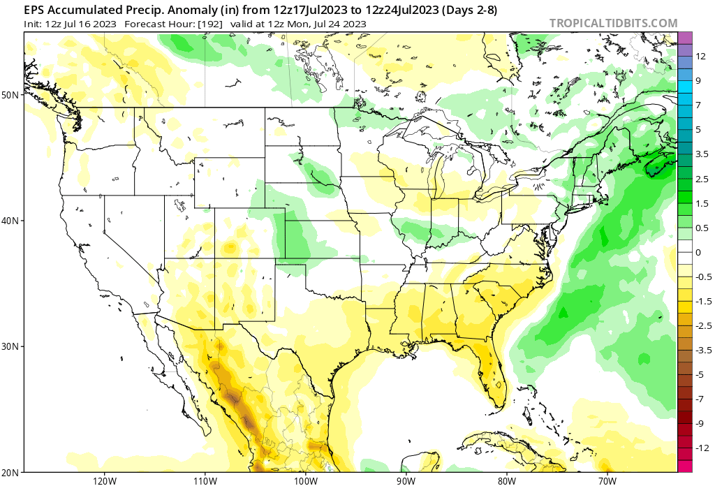
Above: a European Ensemble plot predicting another near to above normal precipitation week ahead for New England.
Monday
Tomorrow we're right back to sunny, hot, and humid conditions. It may actually be the warmest day of the week, with high temperatures inland in the upper 80s to low 90s. It should stay dry, however, in the wake of our latest rain event. We may see some drop in dew points after the boundary passes, but overall it's still humid. The GFS is actually a good example of this, with high dew points dropping in the afternoon only to rise again by evening. That's not much relief.
Tuesday
Tuesday brings our next chance for rain as another boundary/weak impulse moves into the region. It doesn't look like a washout, but we will see heightened chances of showers and thunderstorms during the afternoon and evening. Temperatures will be in the mid to upper 80s, with humidity levels rising.

Above: the latest high resolution NAM depicting storm chances on Tuesday. Most of the activity stays north, but we're far enough out to keep watching as the exact result will change.
Wednesday-Friday
The latter half of the week returns us to the unsettled pattern. The pattern has consisted of frequent impulses "cutting off" over the Great Lakes region, causing air flow to come in from the Atlantic and bring high humidity. It has also kept us from seeing high end air temperatures--the 95 degree days we can see in mid to late July--but it hasn't made much of a difference in sensible weather, as even yesterday we saw lower air temperatures and heat indices in the mid to upper 90s.
Wednesday and Thursday look mostly quiet. Wednesday should be sunny and warm while Thursday will have a chance of showers and storms typical of summer. Still plenty humid.
Friday is a day we're going to be watching a little closely, as another system is poised to develop and move to our north. That will once again put us in the warm sector, where bouts of heavy rain and storms are possible. It's still fairly far out, so it's something to casually watch for now.
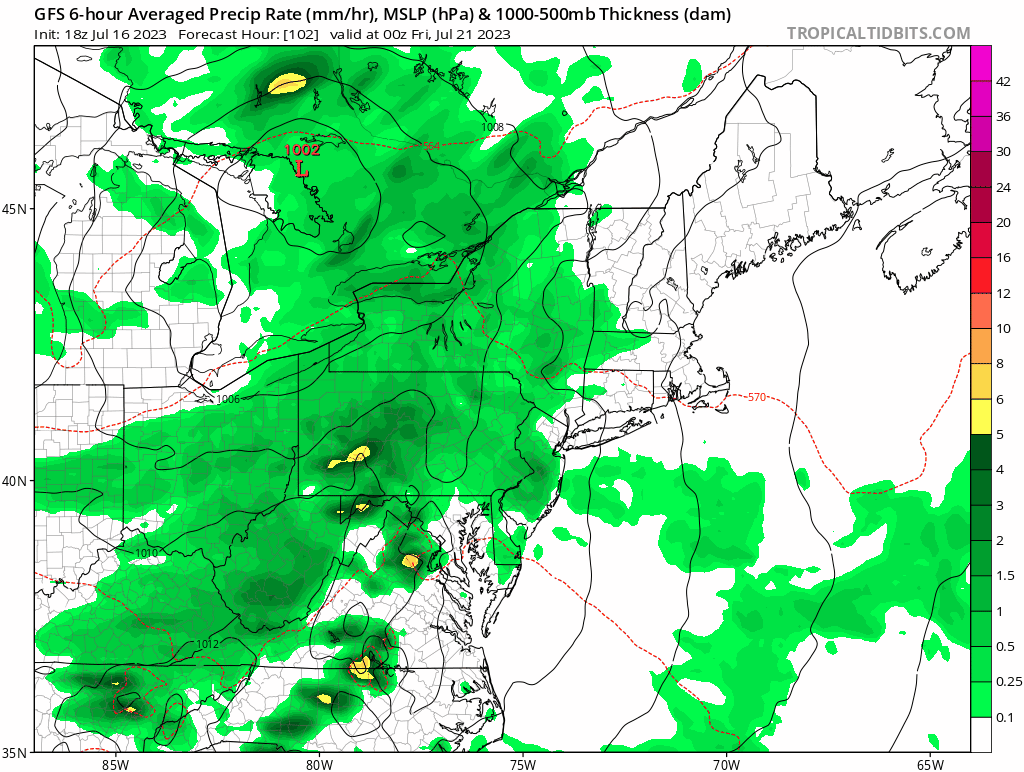
Above: the 18z GFS depiction of Friday. It is more robust that the Euro currently, but given the overall pattern, I lean toward a more impactful system than just showers on Friday.
Saturday-Sunday
The last few weekends have had a bunch of question on the weather, and the coming weekend looks no different. We know it'll be humid, but while the GFS has a quiet weekend in the wake of Friday's potential rain the Euro has a boundary on Saturday that gets tied up over the region that would bring lower temperatures and more rain. Not sure which to believe in yet, but again, given the overall pattern it may be good to introduce more rain odds Saturday in case the Friday rain the GFS is highlighting is slower to move in and out.
The Dailies
Monday: Mostly sunny, hot, and humid. Highs in the upper 80s to low 90s.
Tuesday: Partly sunny with rising humidity and a chance of showers/storms in the afternoon. Highs in the mid to upper 80s. Chance of rain 40%.
Wednesday: Mostly sunny. Highs in the mid to upper 80s.
Thursday: Partly sunny with a chance of showers/storms in the afternoon. Highs in the mid to upper 80s. Chance for rain 30%.
Friday: Mostly cloudy with rain and thunderstorms. Highs in the low to mid 80s. Chance of rain 60%.
Saturday: Partly sunny with a chance of rain and thunderstorms early. Highs in the low to mid 80s. Chance of rain 30%.
Sunday: Partly sunny. Highs in the low to mid 80s.
Finally, while the tropics have been quiet, things may start to heat up in the next few weeks as we start approaching the climatological peak of the season. As you may have heard, there is a lot of uncertainty on what will happen in the Atlantic basin, but as we've seen, it only takes one storm to make a bad season. It's never a bad time to examine your storm preparedness.
As always, please like, share, and interact with us on our social media--on Facebook to share our discussions, and follow us on Twitter @southernctwx to retweet our posts. Hit the buttons below to join.
Thank you for reading SCW.
-DB
