Today was one of the more beautiful days in recent memory across the area. There will still be beautiful days in the upcoming pattern, but the overall pattern will become more active and changeable across the area.
Tonight: With low relative humidites and dry soil, as well as clear skies and diminishing winds, radiational cooling should be able to take hold and temperatures should be able to fall rapidly after dark. Lows should range from the mid 30s to around 40, possibly warmer in the urbanized locations along the south coast.
Tomorrow: Although there will be abundant sunshine, temperatures will be quite a bit cooler than those of today, especially across the southern zones, where it was significantly warmer than the northern zones today. The air mass aloft tomorrow is significantly cooler than that of today. As a result, high temperatures will generally be in the lower 60s, though the Bridgeport and New Haven areas could see readings a few degrees warmer.
Tomorrow Night into Thursday: With calm winds tomorrow night, there will be a much larger difference in temperatures between areas that are known to radiate well and urban areas. Temperatures will range from near freezing in the typical colder spots to the mid 40s in the warmer locales. Thursday should be a beautiful day. Clouds may increase ahead of the next system later in the day, especially in the Southwest, but other than that, it should be a sunny and pleasant day, with high temperatures generally ranging from the upper 60s to around 70. With the flow becoming southerly, coastal locations will be cooler than inland areas. In fact, areas along the immediate southeast coast could be stuck in the low 60s, while the Connecticut River Valley could be into the mid 70s.
Longer Term: The overall longer term pattern will become more active and changeable. The first system in the long term will occur at the very beginning of the long term period. On Friday, a complex storm system will approach the region. Basically, this system will be comprised of a frontal system with various waves of low pressure moving along it. Although this forecast is fairly low-confidence, because we have frontal waves, and a lot can depend on the timing and exact location of the waves. But for now, the best consensus idea is for the first scattered showers to arrive in the Southwest well before dawn and around dawn in the Northeast. Rain should become more organized during the day, and may end during the later afternoon hours as a round of thunderstorms. In general, the end timing for now looks to be from mid-afternoon in the Southwest to around the end of rush hour in the Northeast. Temperatures on Friday should be fairly uniform with the clouds and precipitation- generally in the upper 60s.
On Saturday, skies clear and dew points lower again behind the system. A pleasant day, with high temperatures generally in the 60-65 degree range.
On Sunday, sunny but rather crisp for the time of year. Clouds may increase late in the day in the Southwestern zones ahead of the next system. High temperatures will generally stay in the upper 50s. Morning lows could again dip below freezing in the northern half of the state.
The next system, an overrunning rain storm, as the state stays in the cold sector, begins to affect the state on Monday. Current models are actually showing some rain rotating into the eastern areas first. Either way, the first showers should move into the state during the morning hours. This system will likely not move much, so rain could continue on and off all of the day on Tuesday, and perhaps (going beyond the long term) even into part of Wednesday. Since the state will likely remain in the cold sector, it will also likely be a chilly rain. High temperatures Monday and Tuesday will probably not reach 60 degrees.
Looking into the long range, as advertised above, the pattern will likely be active and changeable. This area often gets caught in the crosshairs between the warm air masses that move up across the Mid-Atlantic states and the cool, maritime air masses from Eastern New England and Eastern Canada. This is exactly what could be happening in the long range, as various frontal boundaries look to move around very near the state. This means that more often than not, rain may be falling, and there may be wide temperature swings from day to day.
Now, here is a look at the two upcoming weather systems in graphical format. First, let's take a look at the system slated to effect the state on Friday.
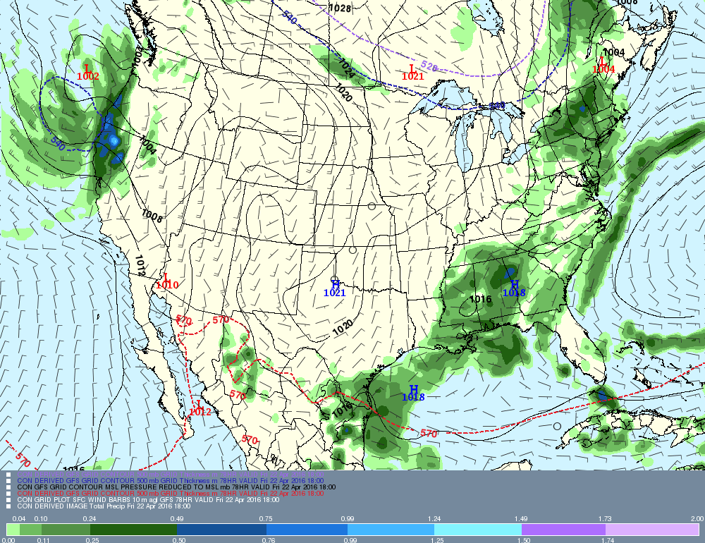
Here we can see that although the low pressure system is over Maine, the trailing cold front is stretching from Northwestern Connecticut down into Eastern Pennsylvania. A fairly significant area of rain over New York State, behind the cold front, (an anafrontal setup), is headed toward the state, especially the northern half of the state.
Now, let's look at the system that will be affecting the state Monday and Tuesday.
Now, let's look at the system that will be affecting the state Monday and Tuesday.
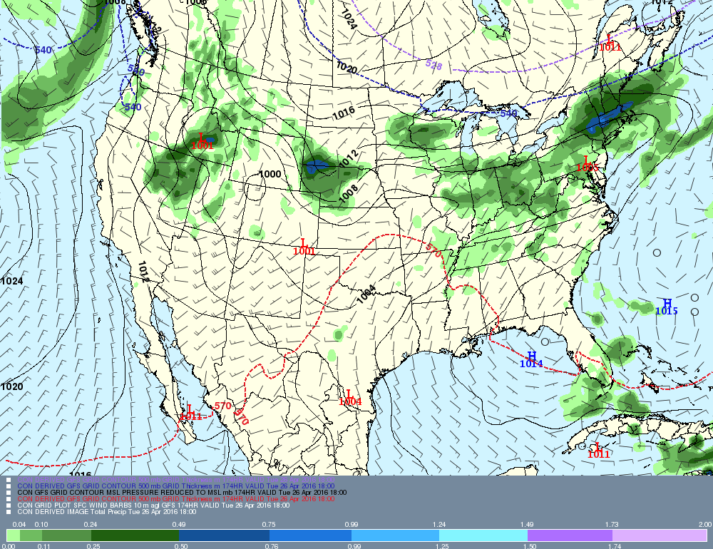
This map, valid midday Tuesday, shows low pressure near Philadelphia. The heaviest rain by then is to our north over Massachusetts. However, some rain remains across the state. Obviously, positions of individual features on day 7 is far from certain. A further north placement of the low would result in less steady precipitation, scattered thunderstorms, and warmer temperatures. A further south placement of the low would result in colder temperatures and steadier and heavier precipitation. Stay tuned!
That's all for now! Enjoy the rest of this beautiful day!
-GP!
That's all for now! Enjoy the rest of this beautiful day!
-GP!
