Most of the focus of this discussion will be on a potentially very large winter storm to affect the state, since there isn’t a whole lot of exciting weather happening before that time.
Tonight: Clear and cold. Since winds will stay up, we won’t see a huge temperature gradient. Temperatures should be in the teens throughout the state.
Tomorrow: Sunny and cold, but with diminishing winds. As high pressure gets closer to the state, winds will diminish. It will still be cold, however, with high temperatures ranging from the upper 20s to near 30.
Tomorrow Night and Wednesday: Basically seasonal without much happening. Temperatures will moderate a little, but still cold, with lows generally 15 to 20, and highs in the mid 30s.
Medium Range (before the storm): A clipper system will pass to our south Wednesday night. Any snow associated with this system should stay south of the region, but this system will still be of importance, since this is the energy that will phase with the low coming up out of the Gulf of Mexico that can produce our winter storm. Temperatures Wednesday night and Thursday will be cold and typical for mid-winter, but nothing too exciting. Low temperatures should be within a few degrees of 20 and highs should be in the low to mid 30s. The next piece in the evolution of the pattern will be a small, but significant enough, push of cold air behind the clipper system. It isn’t an overly strong cold front, but it should be just strong enough to bring sufficient cold air in to feed our storm. Temperatures will be a few degrees cooler Thursday night, from the low teens to around 20, with highs Friday in the low 30s.
Storm Discussion: A large and powerful storm system is expected to eject from the lower Mississippi Valley then move up the east coast, before stalling somewhere between the Delmarva and just off the coast of New Jersey. Depending on where that storm stalls could have significant impacts on the weather here in Connecticut.
What We Know: All model guidance is showing a large coastal low pressure system generating at least significant snowfall for the state. In fact, there is a good deal of guidance that brings an all-out, crippling blizzard to the state, especially to the south coast. This is likely to be a long duration event, as the storm stalls or just drifts slowly once it gets to near 40 degrees North latitude. This storm is also likely to produce very strong winds, and again, perhaps for a long duration. Another thing to put into perspective is that we will have astronomically high tides, due to coastal flooding, which would help exacerbate coastal flooding along the south coast.
What We Still Don’t Know: First of all, where will the heaviest bands with the storm set up? And as a related question, where will any dry slot(s) set up? Often, these are questions that cannot be answered until game time. Next, will the extreme solutions verify? Confidence is increasing, because all of “the big three” (not GM, Chrysler, and Ford), but the GFS, European model, and Canadian Model have been showing the big one for several runs in a row now. A bigger question borne out of the same question is how far north the extent of the biggest impacts will get? Right now, a lot of guidance is keying on the heaviest snowfall being somewhere in Pennsylvania. However, being that this storm is four days out, and a lot of those details don’t even get resolved until the storm is in-situ, it is best not even to speculate where the highest totals are going to be, or even what general totals will be, just that there is a potential for a multiple-impact, long-duration winter storm.
Impacts: Snowfall: Again, it is far too early to speculate on amounts, but confidence is high that the entire state should at the very least see a plowable snowfall. The biggest question here is the northward extent of the very heavy precipitation. At this time, the highest confidence is south of I-84.
Coastal Flooding: If this storm pans out as modeled, significant coastal flooding issues will be possible along the south coast at times of high tide, especially since we’re already astronomically high.
Wind: If the nor’easter becomes as big as operational guidance suggests, very strong winds would be probable, especially along the south coast. This could create wind damage and power outages.
Summing it all up: The bottom line is, the potential is high for a large and impactful winter storm to affect the state, beginning Friday night, and lasting through Sunday morning. Normally, I wouldn’t rate a potential so high for a Saturday event on a Monday, but when you have so much model agreement, it’s hard not to. However, as can be expected from 5 days out, there are uncertainties in small details that could have an impact on exact affects in Connecticut. Stay tuned to later updates from SCW for details!
Beyond the storm, and admittedly, I haven’t put much focus in the longer range tonight, clearing and near normal temperatures would be expected. A clipper system could bring a little light snow later Monday or Tuesday the 25th-26th. Some modeling is then showing another large storm ejecting from the Gulf of Mexico and then moving up the East Coast a couple days later. All in all, the long range pattern looks very active, with storm threats every few days and cold (enough) air available. I have a feeling this is not going to be the only snowstorm we’ll be talking about in the next few weeks!
Coming back to our current storm of interest, let's take a look at this system through some model maps.
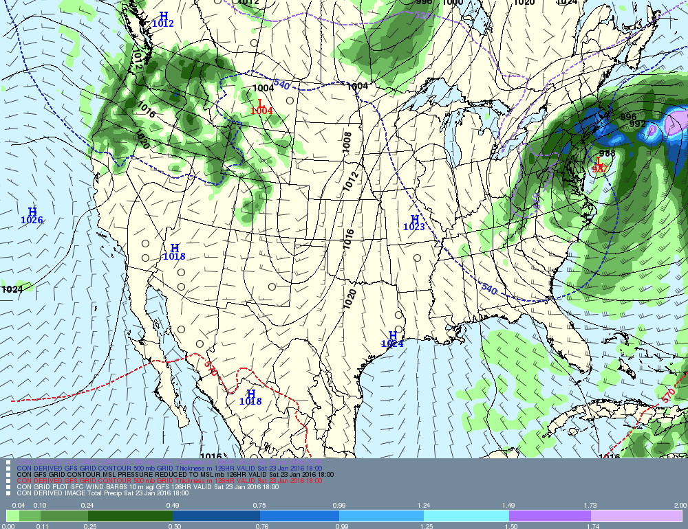
This image is the latest GFS guidance, which shows all the ingredients for a classic snowstorm: tight isobar packing, which would create strong winds, very heavy precipitation, and a slow-moving low pressure system.
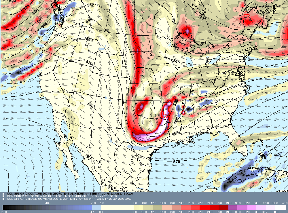
In this image, you can see the 500mb (18,000 feet) vorticity digging all the way into Texas, with the corresponding upper level low over the Ark-La-Tex region. Again, this is a classic feature on all of the biggest Northeastern United States snowstorms.
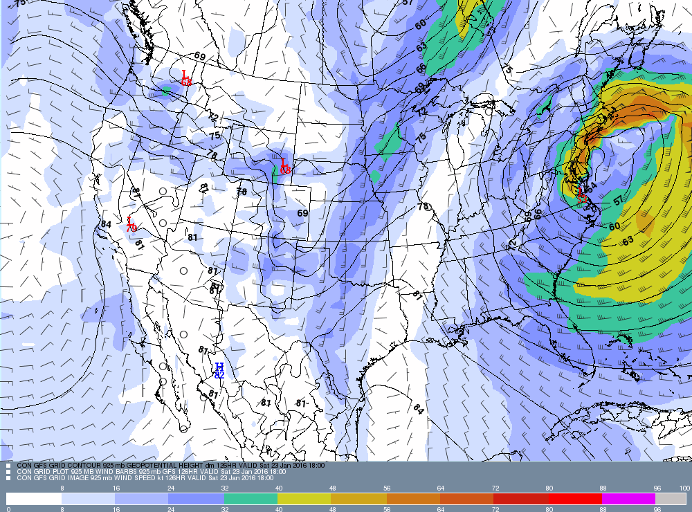
Finally, this map is winds just above the surface. Stronger snow bands, which could be accompanied by thunder and lightning, could bring these winds down to the surface. The orange colors would easily support gusts in the 60-70 MPH range. Look how close those colors get to the south coast!
-GP!
-GP!
