Disc: We will begin to see some threats of wintry wx over the next week, at least over the interior. The pattern may trend a bit more favorable right beyond this fcst pd.
Currently: Main show well offshore, but ULL still across New Eng. Any showers, however, should wrap up after sunset as diurnal instability wanes.
Tonight: We do have fresh CAA, and there will be some clear breaks. In addition, winds will diminish thru the night. Therefore, lows should be just under guidance, generally in the mid to upper 20s.
Tomorrow: Generally went close to guidance for much of the state. However, I feel the NW Hills may have some diurnal cumulus in the afternoon. So in that area, I went a bit under guidance. Generally expect highs around 40, except staying in the upper 30s in the NW HIlls.
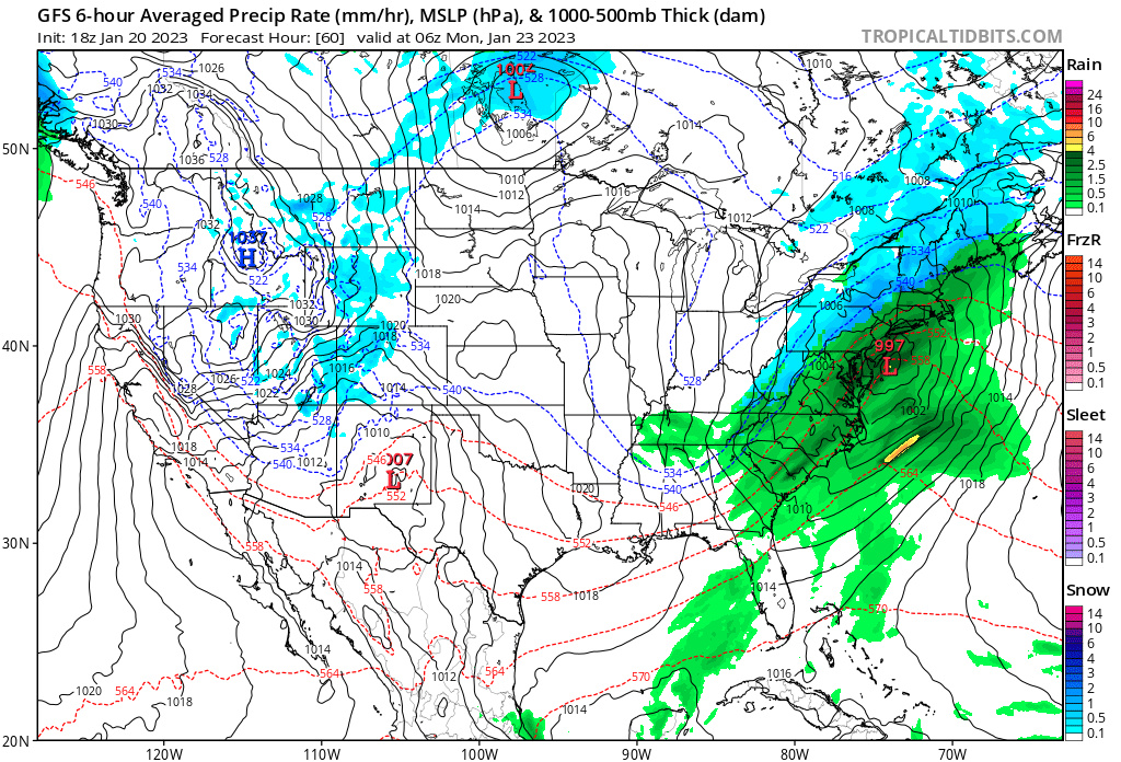
Tomorrow Night/Sun: Clouds increase in the 2nd half of tomorrow night, limiting radiational cooling chances. Pcpn arrives at least in the W half of the state before dark, so I will need to include it during the day pd on Sun. As for temps, went a bit under guidance (a deg or two) w/clouds and pcpn arriving most of the state, but a few more deg off guidance in the NW Hills. Terrain up there should not allow warm air to work in nearly as fast as temp guidance would suggest. I suspect we'll need a winter wx advisory generally N of 84 for 1-2" of snow (maybe a few 3 or 4 inch reports above 1000 feet), and then a pd of icing. NAM suggests winter storm warning possible there, w/advisory possible down to the Merritt, but it is a cold outlier and is being discounted at this time.
Long Term: We'll continue w/a pattern of fast-moving sys, an active Srn jet, and marginal cold air.
Mon: Pcpn ends most areas, except NE CT by dawn. Up there, we may need to watch temps, as it could still be fzra. Otherwise, clearing. Temps a bit tricky. We have fresh CAA (albeit Pac origin), and there prob will be a little snowcover N of 84. Therefore, I went just a deg or so below guidance most zones, but a few more deg under guidance for the 84N crew. So highs generally low 40s, but upper 30s up north. Winds could gust to 40 MPH at times, so it will feel chilly.
Tue: High pressure drfits offshore, so I could see temps turning out a deg or three warmer than what guidance has. We should also have a good deal of sun, so I could see most places reaching the mid 40s. It could still be a bit breezy, bit not as windy as Mon. In addition, and this gives credence to the idea of warmer temps, winds will turn W or SW instead of the NW winds of Mon.
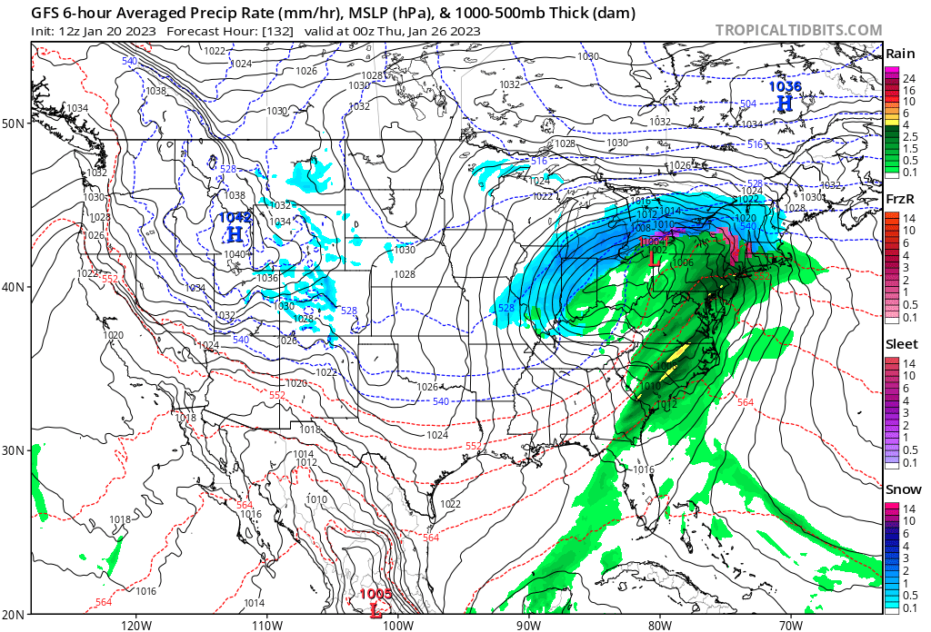
Wed: Next storm moves into the area. This storm could have more of a front-end burst of snow and/or sleet, and it could have at least an hr or two worth of it all the way to the coast, so we may need to watch. However, it also appears to warm quicker at the sfc, so freezing rain should be less of a concern. This one should be more of a snow/sleet then straight to rain mode, which would be easier to predict in that sense. Temps are tricky. Guidance may actually be too cool, but high temps may occur overnight Wed night/Thu AM. So I went under guidance by a few deg to reflect daytime highs. As mentioned, cold air damming does not seem to be an issue as the high pressure up north is more fleeting this time. In fact, by later in the day, winds could be screaming 40-45 MPH gusts out of the S. If that happens, it may actually be warmer N of the Merritt than S, at least for a few hrs.
Thu: We probably clear out all areas except the far NE, by dawn, once again. Guidance seems too cold, w/lingering sfc warmth early in the morn, so I went above guidance by a couple deg. I have mid to upper 40s for highs for now. It could very well be one of those days where the high temp occurs late in the morn after a few hours of sun. Winds could be gusting to 40-45 MPH, making it feel chillier than the actual temps.
Fri: For temps, I went very close to guidance, as we have competing factors- cold air advection behind the departing storm, and weak warm air advection ahead of the next clipper system. Winds diminish, but it stays relatively breezy. High temps generally in the mid to upper 30s.
It should be noted that the clipper that goes by Fri night could leave a light coating of snow, w/Arctic air headed in behind that.
In the long range, it appears there will be more cold air to tap, as the polar jet finally gets involved. It does not look like a perfect pattern, but if you like snow and cold, it is better than what we have had this month so far (though almost anything would be better).
I'll include two images today; the first image is the Sunday night system, the second is the Wed system. The Wed system being stronger helps scour out any cold air faster, but there may be a bit better cold air to start, so we'll have to balance the two.
Currently: Main show well offshore, but ULL still across New Eng. Any showers, however, should wrap up after sunset as diurnal instability wanes.
Tonight: We do have fresh CAA, and there will be some clear breaks. In addition, winds will diminish thru the night. Therefore, lows should be just under guidance, generally in the mid to upper 20s.
Tomorrow: Generally went close to guidance for much of the state. However, I feel the NW Hills may have some diurnal cumulus in the afternoon. So in that area, I went a bit under guidance. Generally expect highs around 40, except staying in the upper 30s in the NW HIlls.
Tomorrow Night/Sun: Clouds increase in the 2nd half of tomorrow night, limiting radiational cooling chances. Pcpn arrives at least in the W half of the state before dark, so I will need to include it during the day pd on Sun. As for temps, went a bit under guidance (a deg or two) w/clouds and pcpn arriving most of the state, but a few more deg off guidance in the NW Hills. Terrain up there should not allow warm air to work in nearly as fast as temp guidance would suggest. I suspect we'll need a winter wx advisory generally N of 84 for 1-2" of snow (maybe a few 3 or 4 inch reports above 1000 feet), and then a pd of icing. NAM suggests winter storm warning possible there, w/advisory possible down to the Merritt, but it is a cold outlier and is being discounted at this time.
Long Term: We'll continue w/a pattern of fast-moving sys, an active Srn jet, and marginal cold air.
Mon: Pcpn ends most areas, except NE CT by dawn. Up there, we may need to watch temps, as it could still be fzra. Otherwise, clearing. Temps a bit tricky. We have fresh CAA (albeit Pac origin), and there prob will be a little snowcover N of 84. Therefore, I went just a deg or so below guidance most zones, but a few more deg under guidance for the 84N crew. So highs generally low 40s, but upper 30s up north. Winds could gust to 40 MPH at times, so it will feel chilly.
Tue: High pressure drfits offshore, so I could see temps turning out a deg or three warmer than what guidance has. We should also have a good deal of sun, so I could see most places reaching the mid 40s. It could still be a bit breezy, bit not as windy as Mon. In addition, and this gives credence to the idea of warmer temps, winds will turn W or SW instead of the NW winds of Mon.
Wed: Next storm moves into the area. This storm could have more of a front-end burst of snow and/or sleet, and it could have at least an hr or two worth of it all the way to the coast, so we may need to watch. However, it also appears to warm quicker at the sfc, so freezing rain should be less of a concern. This one should be more of a snow/sleet then straight to rain mode, which would be easier to predict in that sense. Temps are tricky. Guidance may actually be too cool, but high temps may occur overnight Wed night/Thu AM. So I went under guidance by a few deg to reflect daytime highs. As mentioned, cold air damming does not seem to be an issue as the high pressure up north is more fleeting this time. In fact, by later in the day, winds could be screaming 40-45 MPH gusts out of the S. If that happens, it may actually be warmer N of the Merritt than S, at least for a few hrs.
Thu: We probably clear out all areas except the far NE, by dawn, once again. Guidance seems too cold, w/lingering sfc warmth early in the morn, so I went above guidance by a couple deg. I have mid to upper 40s for highs for now. It could very well be one of those days where the high temp occurs late in the morn after a few hours of sun. Winds could be gusting to 40-45 MPH, making it feel chillier than the actual temps.
Fri: For temps, I went very close to guidance, as we have competing factors- cold air advection behind the departing storm, and weak warm air advection ahead of the next clipper system. Winds diminish, but it stays relatively breezy. High temps generally in the mid to upper 30s.
It should be noted that the clipper that goes by Fri night could leave a light coating of snow, w/Arctic air headed in behind that.
In the long range, it appears there will be more cold air to tap, as the polar jet finally gets involved. It does not look like a perfect pattern, but if you like snow and cold, it is better than what we have had this month so far (though almost anything would be better).
I'll include two images today; the first image is the Sunday night system, the second is the Wed system. The Wed system being stronger helps scour out any cold air faster, but there may be a bit better cold air to start, so we'll have to balance the two.
That's all for now, see you next week!
-GP!
-GP!
