Disc: It is looking more and more like CT snow lovers may have to wait until the winter of 2020-21 to see a widespread large event (meaning widespread 6"+ throughout the state). We still have the end of Feb, all of Mar, and even early Apr, but as the days tick by and the pattern does not change, it gets one day closer until the end of winter. And with each passing day, temp normals rise and chances of snow diminish.
Currently: High pressure over Srn PA will keep fair wx over the state for the next few days. A sprawling storm system across the Gulf Coast states will slide ENE, due to the high pressure being so far S, and will not affect the area.
Tonight: Will need to monitor cloud deck from Srn storm across the S coast. This could keep temps higher there and limit radiational cooling. Otherwise, a chilly night. I'll stay fairly close to guidance tonight, but go a bit cooler here and there. It's a bit of a risk, esp along the S coast, but most guidance has the cloud deck thinning out by midnight, allowing at least half a night's worth of radiational cooling. I don't really see a reason to deviate.
Tomorrow: Sunny and a cold winter's day. Guidance looks pretty good. With full sun and near neutral advection, I'll side toward the warmer GFS guidance. High temperatures should generally be within a few degrees of 30, but 30-35 is possible along the I 91 corridor.
Tomorrow night/ Sat: As high pressure moves offshore, return flow sets up, allowing warmer air to funnel into the region. The NAM and GFS guidance are worlds apart, with the GFS much warmer. I'll side toward the GFS guidance, given good downsloping and full sun. However, I will subtract a degree or two, maybe more than that along the S coast. Localized sea breezes should set up, which should make for temp uniformity. Look for highs in the 40 to 45 degree range.
Long Term (Sun and beyond): The main period of interest in the long-term period will be Tuesday to Thursday. This period centers around a two-part storm system. But until we get there, Sunday should be a beautiful sunny day, Guidance looks reasonable, I may tweak it upward a degree or two in spots with full sun and again a downslope component to the wind. Highs should get close to 50 degrees, except maybe elevated spots N of I 84 staying in the mid 40s.
Clouds will increase on Monday, but no precip is expected. In fact, most precip should hold off until Tuesday morning. It's not entirely impossible for some sprinkles/drizzle very late Mon night, but either way Mon daytime is nice. Temp guidance looks spot on given the time of year and 850 mb temps, so I see no reason to be too cute and make modifications that are not necessary. Expect highs near 50 degrees, except into the low 50s along I 91.
On Tuesday, expect a rainy day. This first part of the storm is not really much of a concern for frozen precip anywhere, as it tracks well west of the area. Rain should fall pretty much all day Tuesday, with the heaviest rain centered around late in the day. My only concern with the fcst for this day is high temps. As is usual this time of year, when a relatively weak low tracks well to the west, the warm front does not just blast thru, despite what models insist. Therefore, I'll go a good 3-6 degrees below guidance and keep highs in the mid to upper 40s.
There should be a decent break on Wednesday. At this point, I think the majority, if not the whole day, on Wednesday, should be dry. However, there won't be much sun. as clouds from the departing system and clouds from the incoming system combine to keep it generally cloudy. The GFS guidance does not seem to realize it will be cloudy, so I'll shave a good 5 degrees off its' printout. Therefore, expect highs near 50 degrees.
Finally, the next storm system affects the area later Wednesday into Thursday, with the heaviest precipitation falling before dawn Thursday. Guidance has waffled around with this system, with some guidance hinting at a chance to some snow. Given the pattern this year, I prefer to lean on the rainier side of things, with the best chances for snow being N of I 84. I'll shave a couple degrees off the GFS guidance, but even doing this yields highs in the 40 to 45 degree range. Colder weather should move into the area the following weekend.
Looking into the long range, I don't see any major changes to the overall long range pattern. Temps may not be quite as warm, relative to normal. heading into March, but normals are much higher. I also do not see any sustained (more than 3 day) cold weather, either. Overall, the pattern does look stormier than normal, but this overall pattern would favor mainly rain events.
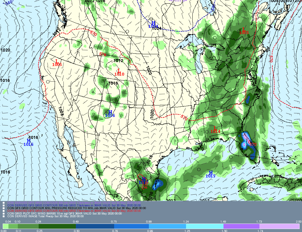
Now, let's look at a few graphical examples of systems slated to affect the area this week. I'll show next week's "duo", since there really isn't anything happening until then. On this image, valid midday Tuesday, you can see rain overspreading the state. A weak low into Pittsburgh probably won't allow the warm front to make it through, which is why I went lower than guidance on temperatures.
Currently: High pressure over Srn PA will keep fair wx over the state for the next few days. A sprawling storm system across the Gulf Coast states will slide ENE, due to the high pressure being so far S, and will not affect the area.
Tonight: Will need to monitor cloud deck from Srn storm across the S coast. This could keep temps higher there and limit radiational cooling. Otherwise, a chilly night. I'll stay fairly close to guidance tonight, but go a bit cooler here and there. It's a bit of a risk, esp along the S coast, but most guidance has the cloud deck thinning out by midnight, allowing at least half a night's worth of radiational cooling. I don't really see a reason to deviate.
Tomorrow: Sunny and a cold winter's day. Guidance looks pretty good. With full sun and near neutral advection, I'll side toward the warmer GFS guidance. High temperatures should generally be within a few degrees of 30, but 30-35 is possible along the I 91 corridor.
Tomorrow night/ Sat: As high pressure moves offshore, return flow sets up, allowing warmer air to funnel into the region. The NAM and GFS guidance are worlds apart, with the GFS much warmer. I'll side toward the GFS guidance, given good downsloping and full sun. However, I will subtract a degree or two, maybe more than that along the S coast. Localized sea breezes should set up, which should make for temp uniformity. Look for highs in the 40 to 45 degree range.
Long Term (Sun and beyond): The main period of interest in the long-term period will be Tuesday to Thursday. This period centers around a two-part storm system. But until we get there, Sunday should be a beautiful sunny day, Guidance looks reasonable, I may tweak it upward a degree or two in spots with full sun and again a downslope component to the wind. Highs should get close to 50 degrees, except maybe elevated spots N of I 84 staying in the mid 40s.
Clouds will increase on Monday, but no precip is expected. In fact, most precip should hold off until Tuesday morning. It's not entirely impossible for some sprinkles/drizzle very late Mon night, but either way Mon daytime is nice. Temp guidance looks spot on given the time of year and 850 mb temps, so I see no reason to be too cute and make modifications that are not necessary. Expect highs near 50 degrees, except into the low 50s along I 91.
On Tuesday, expect a rainy day. This first part of the storm is not really much of a concern for frozen precip anywhere, as it tracks well west of the area. Rain should fall pretty much all day Tuesday, with the heaviest rain centered around late in the day. My only concern with the fcst for this day is high temps. As is usual this time of year, when a relatively weak low tracks well to the west, the warm front does not just blast thru, despite what models insist. Therefore, I'll go a good 3-6 degrees below guidance and keep highs in the mid to upper 40s.
There should be a decent break on Wednesday. At this point, I think the majority, if not the whole day, on Wednesday, should be dry. However, there won't be much sun. as clouds from the departing system and clouds from the incoming system combine to keep it generally cloudy. The GFS guidance does not seem to realize it will be cloudy, so I'll shave a good 5 degrees off its' printout. Therefore, expect highs near 50 degrees.
Finally, the next storm system affects the area later Wednesday into Thursday, with the heaviest precipitation falling before dawn Thursday. Guidance has waffled around with this system, with some guidance hinting at a chance to some snow. Given the pattern this year, I prefer to lean on the rainier side of things, with the best chances for snow being N of I 84. I'll shave a couple degrees off the GFS guidance, but even doing this yields highs in the 40 to 45 degree range. Colder weather should move into the area the following weekend.
Looking into the long range, I don't see any major changes to the overall long range pattern. Temps may not be quite as warm, relative to normal. heading into March, but normals are much higher. I also do not see any sustained (more than 3 day) cold weather, either. Overall, the pattern does look stormier than normal, but this overall pattern would favor mainly rain events.
Now, let's look at a few graphical examples of systems slated to affect the area this week. I'll show next week's "duo", since there really isn't anything happening until then. On this image, valid midday Tuesday, you can see rain overspreading the state. A weak low into Pittsburgh probably won't allow the warm front to make it through, which is why I went lower than guidance on temperatures.
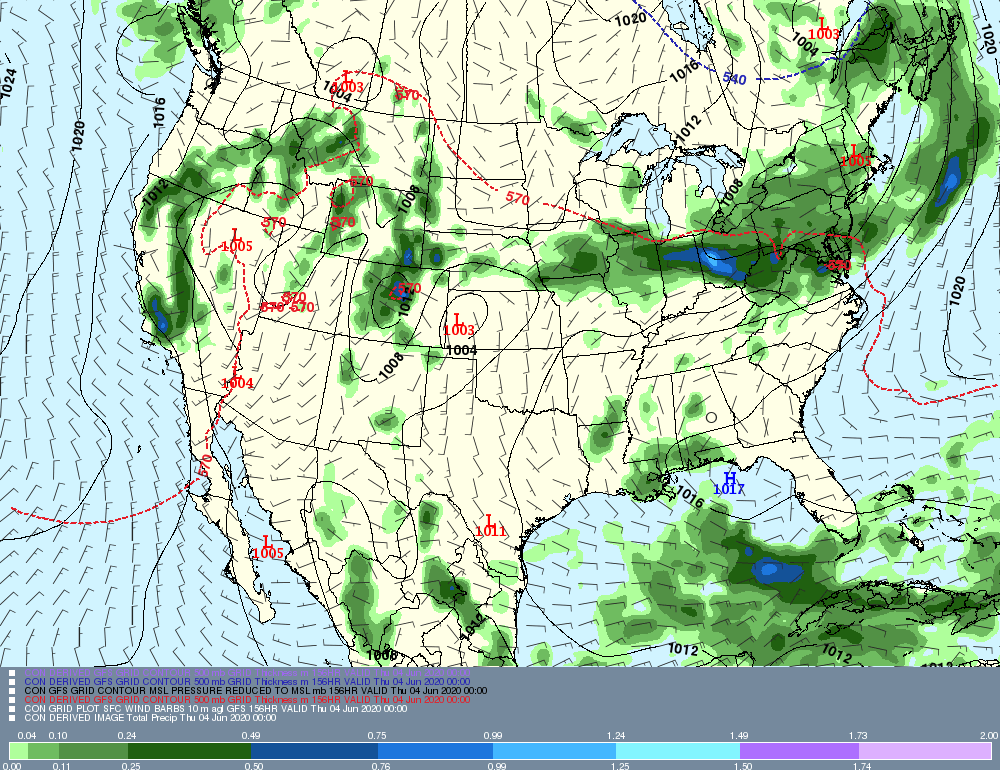
Finally we'll take a look at the second system in the "duo", slated for later Wednesday into early Thursday. Taken literally, this map would be heavy rain and high winds, and maybe just a hint of snow for the north country, but being that it's so far out, we'll take that with a grain of salt.
Anyway, that's all for now! I'll see you next week with potentially some interesting climate statistics regarding this winter.
-GP!
-GP!
