Good evening from Southern Connecticut Weather.
I have a confession to make: I'm nervous.
I'm not really nervous about the forecast itself. After an historic lack of winter thus far, it looks like we will see that period finally try to turn around. But it has to get here.
It should.
The guidance has more or less stabilized, and it's time to make a final call. This will be a shorter discussion than our first call, but the grading will come from this forecast. Let's dive in.
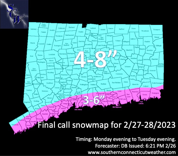
Above: our final call map for Monday-Tuesday. As I alluded to earlier, we have left most of the state in the 4-8" zone, and expect highest totals in the NW and western portion of the state. For the shoreline, with the trend toward colder temperatures during the peak of the storm holding through the day, we have increased the expected snow totals there from 2-4" to 3-6". For this zone, most will likely see total accumulations of 4-6", but we introduced a 3" floor for the immediate shoreline areas that may see lower ratios early Tuesday morning.
The Forecast
Timing
Again, most of Monday looks fine for travel. We expect to see snow develop from west to east, and the guidance has coalesced around a later start time. As a result, we now anticipate snow to begin between 6-10pm. This should leave the evening commute dry for virtually all of CT.
The heaviest snow occurs during the overnight hours, especially the early Tuesday timeframe. Snow will continue through Tuesday morning, and perhaps into the afternoon. However, we expect the bulk of the snow to fall by about 7-8am on Tuesday, and as temperatures warm during the day, accumulation won't be as efficient, especially in southern CT.
Snow Accumulation
There is high confidence in a widespread 4-8 inches of snow. The highest accumulation is likely to be in western Connecticut, especially the NW hills where a winter storm watch is in effect. For the shoreline zone, we took the numbers up and expect most to end up with 4-6". We added the 3" floor because the immediate shoreline is always at risk of slightly lower totals if ratios are lower. I doubt it happens, but I don't want to kick myself afterward in case it does.
As I said last night, in the CT River Valley we always watch for dry slotting. Some guidance shows this. I'm watching NE CT too in case there is less precip squeezed out up there, but we do still expect a widespread 4-8".

Above: the 18z GFS depiction of the storm. It's all snow, for all of CT, on the frames that matter.
Impacts
We expect a moderate impact event. Roads will be messy late Monday through Tuesday morning, but will gradually get better during the day Tuesday. The timing makes it more likely that we see widespread cancellations on Tuesday.
With the continued cold trend, we may see higher ratio snow early Tuesday morning, which results in more fluffy snow. Along the shore, however, temperatures closer to freezing may mean some heavier (read: pasty) snow on Tuesday. We don't expect significant power outages and we don't expect particularly strong winds.
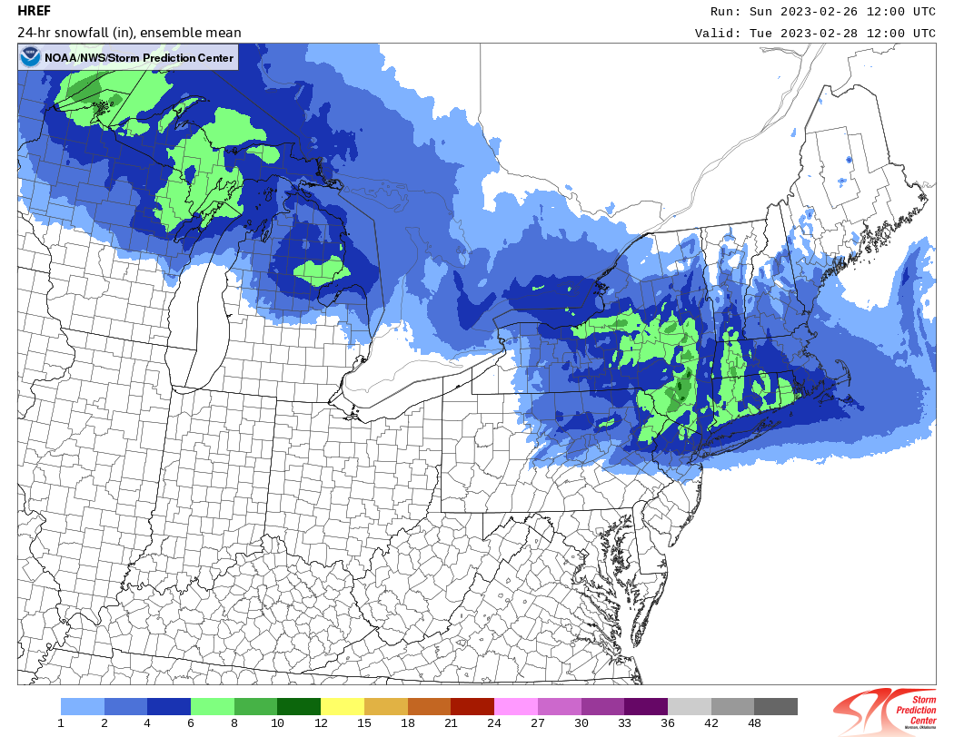
Above: A quite bullish HREF mean for the storm, showing most getting 6-8". We're lower than this, but it increases confidence in our general forecast of a widespread 4-8".
Overall
Overall, this has become a pretty straightforward forecast. We see snow begin in the state from west to east between 6-10pm on Monday, with the heaviest snow falling early Tuesday morning. Snow may linger into Tuesday afternoon, and we anticipate widespread cancellations for a broad 4-8" of snow inland and 3-6" in far southern CT, where most see 4-6".
Moderate impact overall, and then we turn our attention to the end of the work week...
As always, please like, share, and interact with us on our social media--on Facebook to share our discussions, and follow us on Twitter @southernctwx to retweet our posts. Hit the buttons below to join.
Thank you for reading SCW.
-DB
