Good evening from Southern Connecticut Weather.
It's time to make a call, but I really don't want to.
It seems as if we have been following this one for a long time, with a long way to go. Unfortunately, we continue to see a complex and highly sensitive forecast as we get close to the start of the storm.
With winter storm watches now covering most of the state, here is our first call snow map.
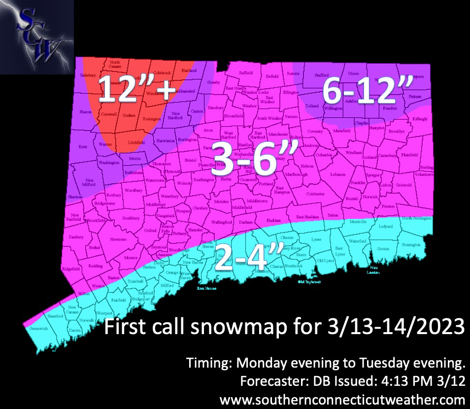
Above: Our first call snow map. We expect that the bulk of snow falls on Tuesday after rain begins later on Monday. Our shoreline zone is at 2-4" because of the high uncertainty over how the system consolidates. Our middle zone has 3-6", and we expect more snow the further north and elevated you are. We have a 6-12" zone for part of eastern CT, Litchfield County, and far northern Fairfield County. The "jackpot" zone is the elevated portion of northern Litchfield County, where snow totals over 1 foot are possible.
I already know how this goes. Some will look at this accumulation map and say
"what major storm!"
"hype"!
If you watched my video discussion you know how explosive a setup this is. Read a little further to understand why we still think this is a major storm with changes possible.
I already know how this goes. Some will look at this accumulation map and say
"what major storm!"
"hype"!
If you watched my video discussion you know how explosive a setup this is. Read a little further to understand why we still think this is a major storm with changes possible.

Above: the latest GFS 500mb depiction of the storm. It's a beautiful depiction for a major storm...but...there's a slight imperfection that throws the entire surface and thus sensible weather into chaos. Can you spot the imperfection?
The Overall Setup
The synoptic evolution is actually pretty straightforward, and it hasn't changed much since yesterday. The powerful storm from the upper Midwest is moving toward the east, and is expected to phase (combine) with the southern stream of the jet.
A coastal low will form from the southern jet off the southeast coast tomorrow, and as it moves northeast it will begin to intensify. When the storm from the upper Midwest (northern stream of the jet) begins to phase, the intensification of the low will become explosive. This, combined with blocking well to our north, will cause the storm to effectively stall and loop near Cape Cod before pulling away on Wednesday.
Here's where it gets complicated, however. How quickly do we see the phasing happen and the coastal low consolidate? The models have waffled all over the place with this, and continue to be split on the eventual outcome. The imperfection is evident in the GFS loop above through the Tuesday time frame, where we see two areas of vorticity. This results in the low pressure lobe I've described previously, which dramatically reduces snowfall potential as it brings warmer air to the state on Tuesday.
On the other side of this is the NAM from earlier today. As you will see below, the phasing happens sooner, which keeps the cold in the state and brings a widespread major snowstorm to the state. A small change with a big difference at the surface.

The Forecast
Timing--High Confidence
We think this is a long duration event, even though Monday is mostly rain. We will see the coastal storm begin to develop tomorrow. It'll be well to the south and normally we wouldn't see precipitation, but we will see what resembles an inverted trough appear as the northern stream energy works toward the region. Temperatures will be too warm for snow anywhere early on. Expect rain showers to develop over the state late tomorrow afternoon. We do not expect any travel issues.
With cooling, snow is expected to break out in the elevated parts of Litchfield County between 6-9pm. The rain/snow line will collapse south and east overnight, particularly between 12am Tuesday and 7am.
This is where it gets tricky. What happens next? If there is no low pressure lobe over CT, the entire state likely stays snow during the day. If there is a lobe over the state, it's going to be a struggle. For now, I take the middle ground. While I don't expect an all out torch in CT on Tuesday, I lean toward a less than perfect phase that keeps the surface a little too warm for some. By Tuesday afternoon we are likely snow statewide with the exception of the coastline where rain is more likely. Tuesday evening should have all of CT as snow, and snow departs very early Wednesday morning, before 5am.
Snow Accumulation--Low Confidence
After moving toward a higher snowfall event yesterday, the midday and later guidance has slid backward in large part because of the low pressure lobe. I don't fully believe it, otherwise we'd go with a Coating to two inches along the shoreline, but it is enough to have us lean more conservative overall.
There is high confidence in our 12+ zone. If you are located in this area, expect a high end snow event. This is a big dog for you.
There is moderate confidence in our 6-12 zone. We think elevation helps significantly in flipping you to snow earlier on Tuesday, and staying snow even if the low pressure lobe or some variation of it makes an appearance. Honestly, there's room to take this zone up, but because there's significant uncertainty on how much low level warmth moves into the state Tuesday, we keep a 6" floor and 12" ceiling, for now.
There is low confidence in our 3-6" zone. This zone really feels the impact of the potential low pressure lobe. If we keep that away, the zone would stay colder and I believe easily accumulate more snow. However, given marginal temperatures and the latest trend of the guidance, we are holding tight on going with bigger numbers. We choose to set a low floor and reevaluate for our final call.
There is moderate confidence in the 2-4" zone. Why is there higher confidence here than the 3-6" zone? It's the shoreline. Regardless of the low pressure lobe potential, the temperatures are warmest here and this zone is last to flip to snow. To be sure, there could be less if the lobe appears, but because we aren't fully endorsing that idea, yet, we keep a higher floor than what could easily be a Coating-2" zone.
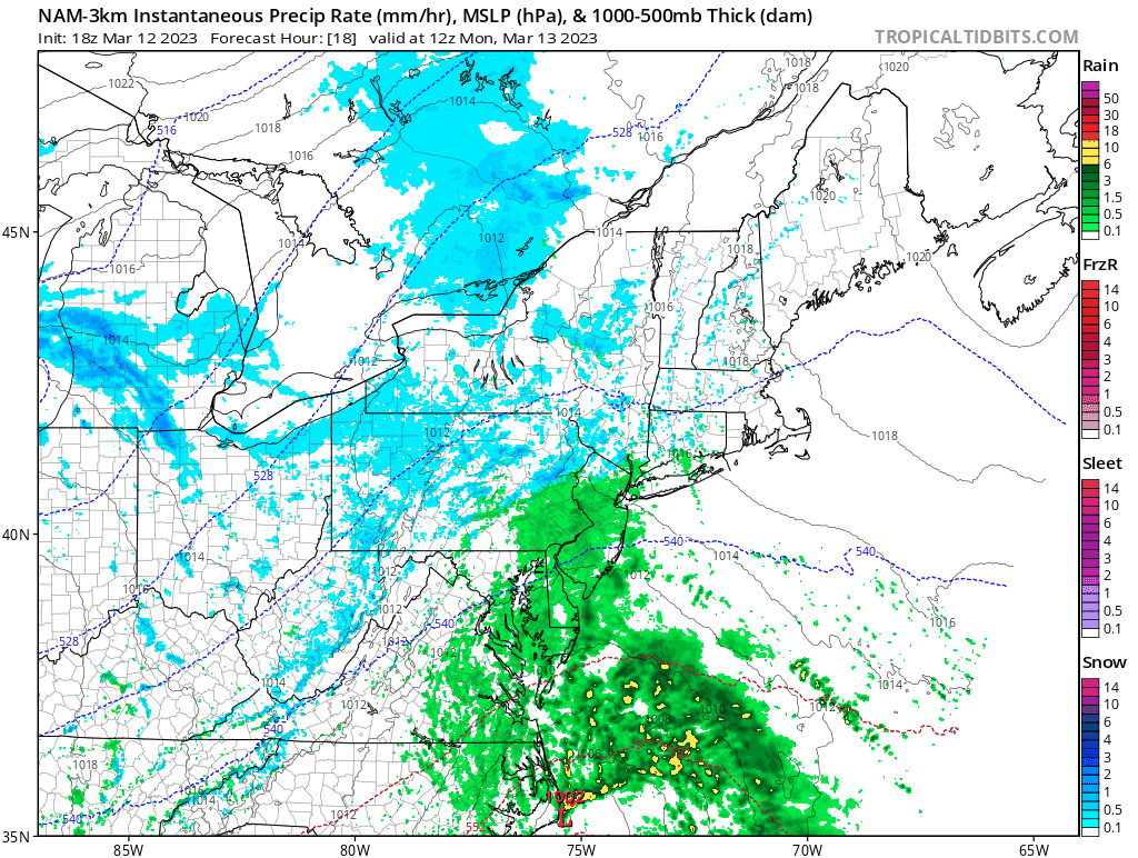
You can easily see the split in guidance. Below is the 18z GFS, which looks good at 500mb but is a strung out mess at the surface.
Timing--High Confidence
We think this is a long duration event, even though Monday is mostly rain. We will see the coastal storm begin to develop tomorrow. It'll be well to the south and normally we wouldn't see precipitation, but we will see what resembles an inverted trough appear as the northern stream energy works toward the region. Temperatures will be too warm for snow anywhere early on. Expect rain showers to develop over the state late tomorrow afternoon. We do not expect any travel issues.
With cooling, snow is expected to break out in the elevated parts of Litchfield County between 6-9pm. The rain/snow line will collapse south and east overnight, particularly between 12am Tuesday and 7am.
This is where it gets tricky. What happens next? If there is no low pressure lobe over CT, the entire state likely stays snow during the day. If there is a lobe over the state, it's going to be a struggle. For now, I take the middle ground. While I don't expect an all out torch in CT on Tuesday, I lean toward a less than perfect phase that keeps the surface a little too warm for some. By Tuesday afternoon we are likely snow statewide with the exception of the coastline where rain is more likely. Tuesday evening should have all of CT as snow, and snow departs very early Wednesday morning, before 5am.
Snow Accumulation--Low Confidence
After moving toward a higher snowfall event yesterday, the midday and later guidance has slid backward in large part because of the low pressure lobe. I don't fully believe it, otherwise we'd go with a Coating to two inches along the shoreline, but it is enough to have us lean more conservative overall.
There is high confidence in our 12+ zone. If you are located in this area, expect a high end snow event. This is a big dog for you.
There is moderate confidence in our 6-12 zone. We think elevation helps significantly in flipping you to snow earlier on Tuesday, and staying snow even if the low pressure lobe or some variation of it makes an appearance. Honestly, there's room to take this zone up, but because there's significant uncertainty on how much low level warmth moves into the state Tuesday, we keep a 6" floor and 12" ceiling, for now.
There is low confidence in our 3-6" zone. This zone really feels the impact of the potential low pressure lobe. If we keep that away, the zone would stay colder and I believe easily accumulate more snow. However, given marginal temperatures and the latest trend of the guidance, we are holding tight on going with bigger numbers. We choose to set a low floor and reevaluate for our final call.
There is moderate confidence in the 2-4" zone. Why is there higher confidence here than the 3-6" zone? It's the shoreline. Regardless of the low pressure lobe potential, the temperatures are warmest here and this zone is last to flip to snow. To be sure, there could be less if the lobe appears, but because we aren't fully endorsing that idea, yet, we keep a higher floor than what could easily be a Coating-2" zone.
You can easily see the split in guidance. Below is the 18z GFS, which looks good at 500mb but is a strung out mess at the surface.

Below the GFS is the 18z high resolution NAM, which is more effectively phased at 500mb and results in a major statewide snowstorm.
Wind--Moderate Confidence
How does a snowfall map like the one above end up being a high impact event? Wind and snow type. While there will be times where snow is likely to be lighter and fluffier, most of the snow is expected to be heavy and wet.
This kind of paste is always an issue, and is a hallmark of March snowstorms. However, even in the absence of a big high pressure to the north (which could have easily made this an historic blizzard) the rapid intensification of the low is likely to bring strong winds.
We anticipate maximum wind gusts between 35-45mph inland, and between 40-50mph along the shoreline. Highest gusts would be in eastern and SE CT. The winds are strongest in CT on Tuesday as the storm rapidly intensifies to our east.
Power Outages--Moderate Confidence
The wind forecast leads us to the power outage forecast. Many of you already received a text from Eversource about the storm, so you know this is one to pay attention to. The combination of strong winds and heavy wet snow means that scattered power outages are possible for most of the state. In our 12+ zone and 6-12 zone, we have particular concern that we see scattered to widespread outages.
Folks need to keep in mind that 12-18 inches of powder is far less impactful than 4-8+ inches of paste. The load on trees and power lines is a legitimate concern, even in areas expected to see less snow. The impact only goes up as the snow forecast increases, if it increases.
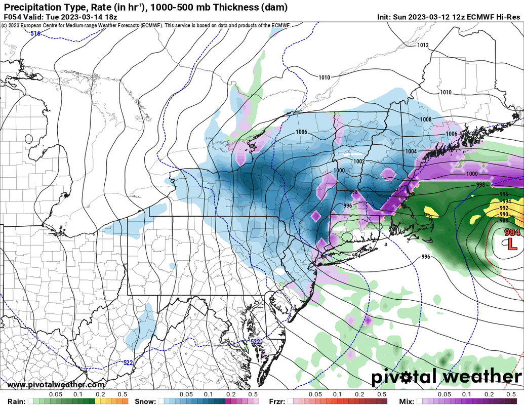
Above: the 18z Euro, which has quickly become more bearish on snowfall in our 2-4 and 3-6 zones due to the low pressure lobe. This is just a single frame, the rain/snow line collapses after this passes, if it even materializes.
Overall Impact--Moderate Confidence
Overall, we envision a moderate to high impact event, with moderate impact in the 2-4 and 3-6 zones and high impact in 6-12 and 12+ zones. Based on the current forecast, we would see widespread cancellations statewide on Tuesday.
I cannot emphasize enough how big a red flag there is with this low pressure lobe that I've talked about ad nauseam this evening. It will have a dramatic impact on the overall outcome of this one. This is one of the most difficult forecasts I've written in over a decade of forecasting. I expect changes in the final forecast, but I honestly can't tell you if they will result in a higher or lower impact.
As always, please like, share, and interact with us on our social media--on Facebook to share our discussions, and follow us on Twitter @southernctwx to retweet our posts. Hit the buttons below to join.
Thank you for reading SCW.
-DB
