Good evening from Southern Connecticut Weather.
Today was about as humid as it gets in New England, with some Connecticut stations with dew points in the upper 70s. In fact, the 5pm New Haven observation had a temperature of 86 with a dew point of 77, leading to a heat index of 97!
It has been a wet July, with all of CT well above normal for July to date and with northern CT at or above 300% of normal rainfall for the month. The oppressive humidity--the moisture in the air, sets the stage for what is looking like an active day again tomorrow.
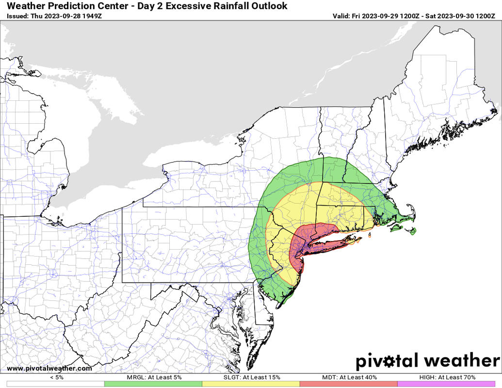
Above: the Weather Prediction Center (WPC) outlook for tomorrow. Most of New England is under a moderate risk. To be clear, this is very different from the SPC severe thunderstorm outlook, where a moderate risk is a really big deal, but with a WPC moderate risk there is still a 40% chance of flash flooding within 25 miles of a given point. Image courtesy of Pivotal Weather.
First, this is not the same setup as we saw this past week in Vermont. A combination of long duration rainfall and elevation-related enhancement led to the catastrophic flooding there.
That said, we have a serious risk of flash flooding on Sunday, especially in the places that have seen the most rainfall recently. In addition, the setup here lends itself to a severe thunderstorm risk, most notably, an elevated risk of a tornado. Let's go into more detail.
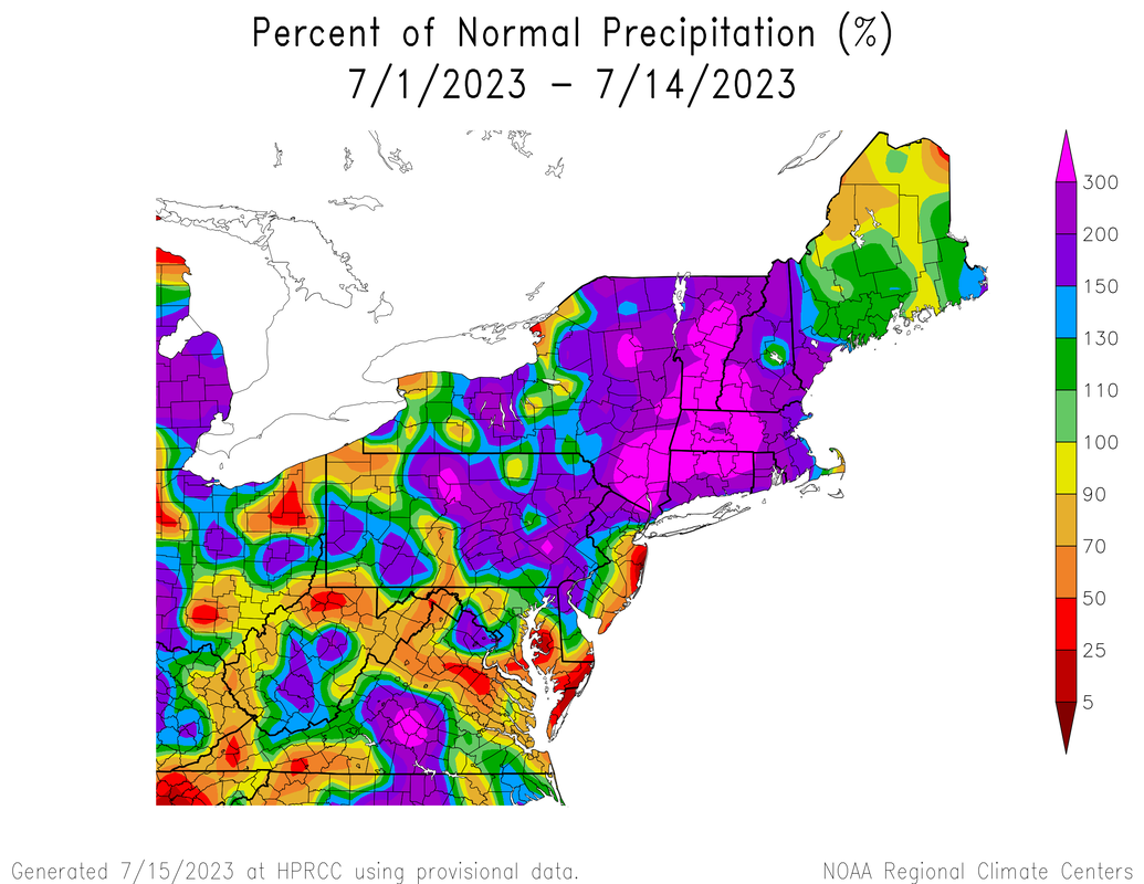
Above: An NRCC plot of the departure from normal for the first half of July. Northern CT through Mass and much of Vermont is 300% or above normal rainfall for the month.
Overview
All of CT is under a Flood Watch, and the CT River under a continued flood warning as the Sunday setup is a classic heavy rainfall signal.
The obscene moisture we have in the air is the first ingredient. Tomorrow we will see even more which as the NWS notes is near the highest we tend to see in the region climatologically speaking. In addition, we will have a slow moving front and strengthening jet that will act as a forcing mechanism, causing showers and storms to develop and push east toward the region.
Flash Flooding Potential & Timing
We expect showers and storms to begin developing in earnest between 4-8am, especially in western CT. Over the course of the day and likely into the evening/nighttime hours we will see rain, heavy at times, with embedded thunderstorms possible. It probably won't rain over your house the entire period as you would see with a coastal storm, but when it does rain, it could be very heavy. The WPC has noted that some areas could get rainfall with rates up to 2" an hour. That would likely cause flash flooding given how saturated our soils are. It'd also increase the risk of rivers and streams to rise quickly.
Overall, we anticipate general rainfall totals between 1-3 inches of rain, but the big caveat is that some areas are almost certainly likely to see higher totals, if not substantially higher totals, based on how many times they get hit with the heaviest convective rains and for how long.
Normally, a standalone 1-3" rainfall isn't worth a discussion of this length, but given the rain we've seen and the potential for higher totals, it's a big enough deal to write about it. This is a shorter duration event thankfully, with the rain expected to end statewide by midnight. The most widespread and heavy rain is likely tomorrow morning into the early afternoon.

Above: 18z high resolution NAM depiction of the rain tomorrow between 4am Sunday and 2am Monday. This will not be exact, but notice how it has very heavy rain and storms over the state, especially mid morning into early afternoon, followed by another possible period in the afternoon. Where these specific cells of heaviest rain will set up is impossible to pin down with precision.
Severe Thunderstorm Potential
The SPC has put CT in a marginal risk of severe weather tomorrow, but that doesn't tell the whole story.
In addition to the marginal risk, the SPC has put much of CT under a 2% risk of a tornado. Looking at the setup, it makes sense. We will have heightened shear in the atmosphere as the front approaches. This is significant, as it will allow for more organized storms. That does two things: first, it allows for showers/storms to most efficiently produce rainfall, hence the flash flood threat. The second thing it does is provide a window for strong thunderstorms to rotate.
As a result, this is something to watch closely tomorrow morning and afternoon. This is more of a conditional threat, meaning that if we don't get another ingredient to reach critical mass, there is no real threat. Tomorrow, we will be looking for instability. We can probably get some strong to severe storms even without a lot of instability, but if we're able to get breaks in the rain and clouds tomorrow to allow for more instability that enhances the risk for strong winds and a potential tornado. This is a little inside baseball, but we also see higher levels of helicity (low level spin) and lower LCLs that could make some thunderstorms surface based, even if briefly.
The rainfall is the biggest threat, but we will be watching for any quick spin up potential tomorrow any time during the morning and afternoon.
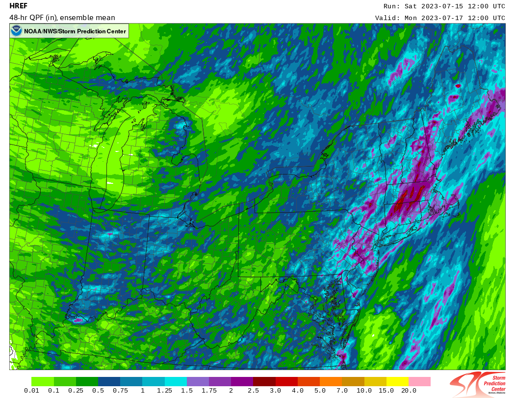
Above: the SPC HREF Ensemble, showing the mean 48 hour precipitation for this event. It's quite robust, showing the general 1-2" rainfall but even 2.5-3+ inches as a mean in northern CT. That is something to pay attention to.
Overall
This is the latest in a series of systems that will bring heavy rain to the state. The challenge is that with each successive rain event we increase the chance of flash flooding, and that's the case here.
Areas that see training of cells or extremely heavy rainfall will be at highest risk, and that could be anywhere in the state, though NW CT and northern CT are most likely to get the heaviest rainfall. In addition we have a low, but not zero chance of storms that acquire enough rotation for a quick tornado. This is particularly true if we see higher instability build late tomorrow morning into the afternoon.
It is a day to keep the eye to the sky and radar, and stay away from any flooded roads if you are out.
As always, please like, share, and interact with us on our social media--on Facebook to share our discussions, and follow us on Twitter @southernctwx to retweet our posts. Hit the buttons below to join.
Thank you for reading SCW.
-DB
