Good evening from Southern Connecticut Weather…
Happy November! The clocks are back an hour and with Thanksgiving a few weeks away a lot of us are already looking ahead to real fall weather.
Today wasn’t the best of days, with clouds lingering all day and a few showers lingering along the coast. Tomorrow isn’t much better, with a cold front moving through late in the day and evening that should bring more showers. After that however, things turn sunny, dry, and seasonable, with the chance of the first real cold shot by the weekend.
Monday
As I mentioned, tomorrow should be relatively similar to today, with clouds early and warmer than normal temperatures. However, by the afternoon and evening we should see a period of showers as a cold front pushes through and settles to the south of the region. That will knock down our temperatures for the rest of the week, as a different pattern takes over that allows for more seasonable conditions.

Tuesday-Thursday
The middle of the week looks tranquil. As the cold front passes on Monday, high pressure settles in, bringing dry and seasonable conditions. It looks like we will see highs in the low to mid 50s across the state with lows getting down into the 30s even near the shore.
The middle of the week looks tranquil. As the cold front passes on Monday, high pressure settles in, bringing dry and seasonable conditions. It looks like we will see highs in the low to mid 50s across the state with lows getting down into the 30s even near the shore.
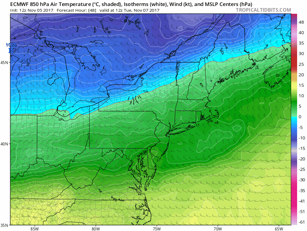
Euro 850 temperatures. These are not surface temperatures, but are a nice illustration of the push toward more seasonable surface temperatures…and below normal by the weekend…
Friday-Sunday
As you could see above, a strong push of cold looks poised to reach the region by Friday. On Friday, a cold front will move through the state. It currently looks like a dry front. However, in the wake of the front we should see our first legitimate cold shot of the season.
It is going to feel like late fall, with temperatures potentially struggling out of the 30s inland by Saturday. Sunday could be a bit warmer, but by then we are watching a system potentially develop and move in from the west late Sunday or on Monday. It is something to watch for our next chance at precipitation. Right now, the cold shot looks quick. We'll have to watch and see if the cold shot becomes more of cool shot (meaning warmer than currently expected temperatures) by the end of the week.
The Dailies
Monday: Mostly cloudy with showers by afternoon. Highs in the low to mid 60s. Chance of rain 80%.
Tuesday: Clearing early with dry conditions. Highs in the low to mid 50s.
Wednesday: Partly cloudy. Highs in the low to mid 50s.
Thursday: Mostly sunny. Highs in the low to mid 50s.
Friday: Partly cloudy and slightly cooler. Highs in the upper 40s to low 50s. Lows in the low to mid 30s.
Saturday: Mostly sunny, breezy, and chilly. Highs in the upper 30s to low 40s. Lows in the mid to upper 20s.
Sunday: Increasing clouds. Chance of showers or rain/snow showers in northwest hills late. Highs in the low to mid 40s. Lows in the 40s at the shore and mid 30s inland. Chance of precipitation 20%.
As always, please like, share, and interact with us on our social media--on Facebook to share our discussions, and follow us on Twitter @southernctwx to retweet our posts. Hit the buttons below to join.
Our winter forecast is coming soon! Stay tuned.
- DB
